Nubbery Moss

Downs, Moorland in Dumfriesshire

Scotland

Nubbery Moss

Between  Blue Cairn and Greygill Head A gentle broad ridge with a contrast between grass on one side of the fence and dyke and heather on the eastern side. The heather soon gives way to Sitka spruce.
Between Blue Cairn and Greygill Head Credit: Richard Webb

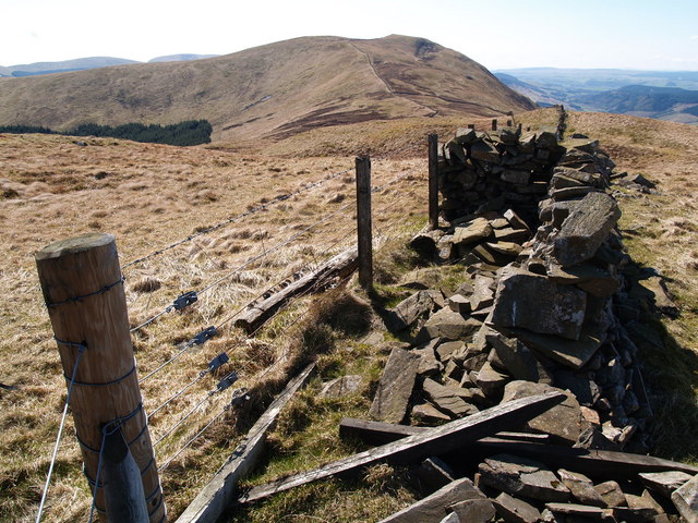
Nubbery Moss is a captivating expanse of downs and moorland located in Dumfriesshire, Scotland. Spanning over a vast area, this stunning natural landscape offers a diverse range of features that attract visitors from far and wide.

The moss boasts a unique blend of rolling downs and wild moorland, creating a picturesque setting that is a haven for nature enthusiasts and outdoor adventurers. The downs, with their gently sloping hills, are blanketed in lush, green grasses and dotted with colorful wildflowers during the warmer months. This creates a delightful sight for those who enjoy leisurely walks or picnics in serene surroundings.

The moorland, on the other hand, provides a more rugged and untamed experience. Its vast expanses of heather and gorse create a magnificent purple carpet that stretches as far as the eye can see. This untamed landscape is home to a variety of wildlife, including rare bird species such as the golden eagle and the peregrine falcon. Visitors may also encounter red deer, foxes, and other creatures as they explore the moss.

Nubbery Moss offers a network of well-maintained trails, allowing visitors to explore the area at their own pace. Additionally, there are designated viewpoints strategically placed throughout the moss, providing breathtaking panoramic views of the surrounding countryside.

Whether it's the tranquility of the downs or the rugged beauty of the moorland, Nubbery Moss offers a captivating experience for nature lovers. Its diverse landscapes, abundant wildlife, and scenic trails make it a must-visit destination for those seeking to immerse themselves in the natural beauty of Dumfriesshire.

If you have any feedback on the listing, please let us know in the comments section below.

Nubbery Moss Images

Images are sourced within 2km of 55.383959/-3.4070242 or Grid Reference NT1010. Thanks to Geograph Open Source API. All images are credited.

Between  Blue Cairn and Greygill Head A gentle broad ridge with a contrast between grass on one side of the fence and dyke and heather on the eastern side. The heather soon gives way to Sitka spruce.
Between Blue Cairn and Greygill Head
A gentle broad ridge with a contrast between grass on one side of the fence and dyke and heather on the eastern side. The heather soon gives way to Sitka spruce.
Quarry below Blue Cairn Beyond the grassed over quarry, Swatte Fell emerges from the clag.
Quarry below Blue Cairn
Beyond the grassed over quarry, Swatte Fell emerges from the clag.
Forestry, Birnock Water A 1980s  and therefore still uniform forestry plantation upstream of Moffat.  It is getting less common seeing a big block without felled areas now, as big plantations fell out of favour in the mid 1980s. They are being planted again though, very much back in favour.
Forestry, Birnock Water
A 1980s and therefore still uniform forestry plantation upstream of Moffat. It is getting less common seeing a big block without felled areas now, as big plantations fell out of favour in the mid 1980s. They are being planted again though, very much back in favour.
The road in the Birnock Water forest A wet dark afternoon with a bit of a feel of Winter about it.
The road in the Birnock Water forest
A wet dark afternoon with a bit of a feel of Winter about it.
Lower slopes of Swatte Fell On the lower slopes of the Donald Swatte Fell above Upper Coomb Craig looking across to Under Saddle Yolk and Saddle Yolk. The Corbett of White Coomb is at left of picture. A glorious autumn day.
Lower slopes of Swatte Fell
On the lower slopes of the Donald Swatte Fell above Upper Coomb Craig looking across to Under Saddle Yolk and Saddle Yolk. The Corbett of White Coomb is at left of picture. A glorious autumn day.
The new path descends towards the Auchencat Burn Just beyond the deer fence, a landslide has blocked the old path to the Spa. This new route continues much higher up the hillside before descending nearer to the Spa.
The new path descends towards the Auchencat Burn
Just beyond the deer fence, a landslide has blocked the old path to the Spa. This new route continues much higher up the hillside before descending nearer to the Spa.
The deep cleft of the Spa Well Burn In this cleft lies Hartfell Spa.
The deep cleft of the Spa Well Burn
In this cleft lies Hartfell Spa.
Disused fanks by the Auchencat Burn
Snowdrift remnant on Well Rig Sheep on top of the slope gives some idea of scale
Snowdrift remnant on Well Rig
Sheep on top of the slope gives some idea of scale
Swatte Fell from the air A snow covered Swatte Fell, just north of Moffat, viewed from a Glasgow bound flight from Luton. The long finger of Roundstonefoot plantation can be seen on the right.
Swatte Fell from the air
A snow covered Swatte Fell, just north of Moffat, viewed from a Glasgow bound flight from Luton. The long finger of Roundstonefoot plantation can be seen on the right.
Swatte Fell from the air A snow covered Swatte Fell, just north of Moffat, viewed from a Glasgow bound flight from Luton. The long finger of Roundstonefoot plantation can be seen in the lower right corner.
Swatte Fell from the air
A snow covered Swatte Fell, just north of Moffat, viewed from a Glasgow bound flight from Luton. The long finger of Roundstonefoot plantation can be seen in the lower right corner.
Looking towards my ski tracks between Newton Fell and Hartfell Spa
Hart Fell Exposures along the Spa Well Burn show up well.
Hart Fell
Exposures along the Spa Well Burn show up well.
Nether Coomb Craig (summit) The summit cairn on Nether Coomb Craig.
Nether Coomb Craig (summit)
The summit cairn on Nether Coomb Craig.
Nether Coomb Craig The summit cairn on Nether Coomb Craig.
Nether Coomb Craig
The summit cairn on Nether Coomb Craig.
Summit of Swatte Fell Small cairn on an area of peat hags marks the summit of the hill.
Summit of Swatte Fell
Small cairn on an area of peat hags marks the summit of the hill.
Fence junction on Swatte Fell Most of the flat summit area of the hill is covered in peat hags.
Fence junction on Swatte Fell
Most of the flat summit area of the hill is covered in peat hags.
Blue Cairn Gentle moorland on the east side of Swatte Fell. Quite a contrast to much of the hill which can be extremely steep.
Blue Cairn
Gentle moorland on the east side of Swatte Fell. Quite a contrast to much of the hill which can be extremely steep.
Show me another place!

Nubbery Moss is located at Grid Ref: NT1010 (Lat: 55.383959, Lng: -3.4070242)

Unitary Authority: Dumfries and Galloway

Police Authority: Dumfries and Galloway

What 3 Words

///riding.hiked.befitting. Near Moffat, Dumfries & Galloway

Nearby Locations

Nubbery Moss Blue Cairn

Related Wikis

Have you been to Nubbery Moss?

Leave your review of Nubbery Moss below (or comments, questions and feedback).