Grange Park

Downs, Moorland in Devon Teignbridge

England

Grange Park

Bishopsteignton Bishopsteignton is a large village on the north bank of the Teign Estuary, 1-2 miles west of Teignmouth - viewed here from the south above Ringmore.
Bishopsteignton Credit: Colin Smith

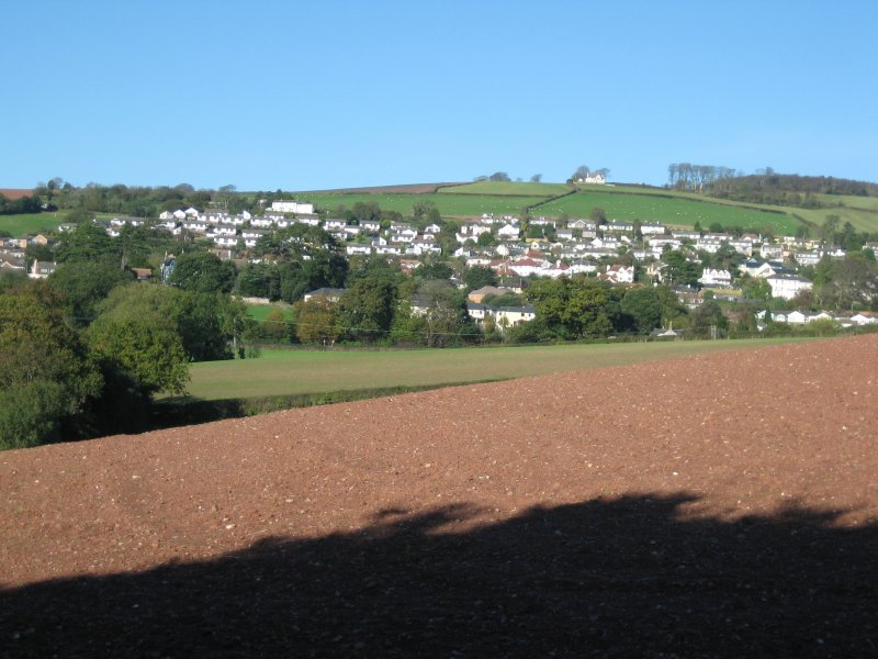
Grange Park is a picturesque area located in Devon, England, known for its stunning landscape and natural beauty. It is situated on the outskirts of the town of Tiverton and covers a vast expanse of downs and moorland, making it a haven for outdoor enthusiasts and nature lovers.

The park offers a diverse range of habitats, including rolling hills, open grasslands, and heathland, which provide a home to a variety of flora and fauna. Visitors can expect to see an array of wildflowers, such as heather and gorse, as well as native bird species like skylarks and buzzards. The park also boasts several walking trails, allowing visitors to explore the area's natural wonders and enjoy breathtaking views of the surrounding countryside.

In addition to its natural attractions, Grange Park is also home to a number of historical sites and landmarks. The park is dotted with ancient burial mounds and stone circles, providing a glimpse into the area's rich history. There are also remnants of old settlements, including ruins of farmhouses and medieval buildings, which add to the park's cultural significance.

Grange Park offers a peaceful and tranquil setting, making it an ideal destination for those seeking a respite from the hustle and bustle of city life. Whether you are looking to immerse yourself in nature, discover the area's history, or simply relax amidst stunning surroundings, Grange Park is sure to captivate and inspire visitors of all ages.

If you have any feedback on the listing, please let us know in the comments section below.

Grange Park Images

Images are sourced within 2km of 50.553657/-3.5535512 or Grid Reference SX9073. Thanks to Geograph Open Source API. All images are credited.

Bishopsteignton Bishopsteignton is a large village on the north bank of the Teign Estuary, 1-2 miles west of Teignmouth - viewed here from the south above Ringmore.
Bishopsteignton
Bishopsteignton is a large village on the north bank of the Teign Estuary, 1-2 miles west of Teignmouth - viewed here from the south above Ringmore.
Combeteignhead : River Teign Looking across the River Teign estuary.
Combeteignhead : River Teign
Looking across the River Teign estuary.
Combeteignhead : Coombe Cellars Inn Looking towards a pub on the banks of the River Teign.
Combeteignhead : Coombe Cellars Inn
Looking towards a pub on the banks of the River Teign.
Combeteignhead : Coombe Cellars Inn As of 2016 it is owned by Mitchells & Butlers.
Combeteignhead : Coombe Cellars Inn
As of 2016 it is owned by Mitchells & Butlers.
Combeteignhead : Coombe Cellars Inn As of 2016 it is owned by Mitchells & Butlers.
Combeteignhead : Coombe Cellars Inn
As of 2016 it is owned by Mitchells & Butlers.
Combeteignhead : River Teign Looking across the river estuary.
Combeteignhead : River Teign
Looking across the river estuary.
Combeteignhead : River Teign Looking across the River Teign estuary.
Combeteignhead : River Teign
Looking across the River Teign estuary.
Combeteignhead : Hearn Field Benches on Hearn Field.
Combeteignhead : Hearn Field
Benches on Hearn Field.
Combeteignhead : Herne Field Pavilion Looking towards Herne Field Pavilion.
Combeteignhead : Herne Field Pavilion
Looking towards Herne Field Pavilion.
Combeteignhead : River Teign Looking along the banks of the River Teign.
Combeteignhead : River Teign
Looking along the banks of the River Teign.
Combeteignhead : River Teign Along the banks of the River Teign.
Combeteignhead : River Teign
Along the banks of the River Teign.
Combeteignhead : River Teign Swan A swan in River Teign.
Combeteignhead : River Teign Swan
A swan in River Teign.
Combeteignhead : Tidelands Looking towards Tidelands.
Combeteignhead : Tidelands
Looking towards Tidelands.
Combeteignhead : Coombe Cellars Inn Coombe Cellars Inn on the River Teign.
Combeteignhead : Coombe Cellars Inn
Coombe Cellars Inn on the River Teign.
Combeteignhead : River Teign Walking along the banks of the River Teign.
Combeteignhead : River Teign
Walking along the banks of the River Teign.
Combeteignhead : River Teign Looking across the river at the estuary.
Combeteignhead : River Teign
Looking across the river at the estuary.
Combeteignhead : River Teign A man and his dog look out across the water (althoug his dog has eyes on the photographer).
Combeteignhead : River Teign
A man and his dog look out across the water (althoug his dog has eyes on the photographer).
Combeteignhead : River Teign Looking towards Arch Brook Hill.
Combeteignhead : River Teign
Looking towards Arch Brook Hill.
Show me another place!

Grange Park is located at Grid Ref: SX9073 (Lat: 50.553657, Lng: -3.5535512)

Administrative County: Devon

District: Teignbridge

Police Authority: Devon and Cornwall

What 3 Words

///feast.buzzing.sized. Near Bishopsteignton, Devon

Related Wikis

Ashwell, Devon

Ashwell is a village in Devon, England.

Bishopsteignton

Bishopsteignton is a village and civil parish in South Devon, England, between Newton Abbot and Teignmouth, close to the Teign Estuary. The village is...

Coombe Cellars

Coombe Cellars Inn is a public house on the south bank of the estuary of the River Teign in south Devon, England. It is in the parish of Haccombe with...
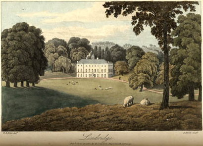
Lindridge House

Lindridge House was a large 17th-century mansion (with 20th-century alterations), one of the finest in the south-west situated about 1 mile south of Ideford...

Nearby Amenities

Located within 500m of 50.553657,-3.5535512
Colway
Place: locality
Lat/Long: 50.5574206/-3.5572082
Turning Circle
Lat/Long: 50.5535627/-3.5500725
Clanage
Place: locality
Lat/Long: 50.5556036/-3.5493479
Forder Cross
Place: locality
Source: digitalglobeOS_OpenData_StreetView
Lat/Long: 50.5498438/-3.5566847
Post Box
Brand: Royal Mail
Brand Wikidata: Q638098
Brand Wikipedia: en:Royal Mail
Collection Times: Mo-Fr 09:00; Sa 07:00; Su off
Drive Through: no
Operator: Royal Mail
Operator Wikidata: Q638098
Post Box Design: type_b
Post Box Mounting: stone_wall
Post Box Type: wall
Ref: TQ14 38D
Royal Cypher: GVIR
Royal Cypher Wikidata: Q33102169
Source: survey;streetlevel imagery;aerial imagery;local knowledge
Lat/Long: 50.5529826/-3.5484472
Generator Method: photovoltaic
Generator Output Electricity: yes
Generator Source: solar
Generator Type: solar_photovoltaic_panel
Location: roof
Power: generator
Lat/Long: 50.552348/-3.5492588
Generator Method: photovoltaic
Generator Output Electricity: yes
Generator Source: solar
Generator Type: solar_photovoltaic_panel
Location: roof
Power: generator
Lat/Long: 50.5525549/-3.547068
Generator Method: photovoltaic
Generator Output Electricity: yes
Generator Source: solar
Generator Type: solar_photovoltaic_panel
Location: roof
Power: generator
Lat/Long: 50.5510347/-3.5538528
Generator Method: photovoltaic
Generator Output Electricity: yes
Generator Source: solar
Generator Type: solar_photovoltaic_panel
Location: roof
Power: generator
Lat/Long: 50.5537321/-3.5528158
Generator Method: photovoltaic
Generator Output Electricity: yes
Generator Source: solar
Generator Type: solar_photovoltaic_panel
Location: roof
Power: generator
Lat/Long: 50.5540064/-3.5512797
Generator Method: photovoltaic
Generator Output Electricity: yes
Generator Source: solar
Generator Type: solar_photovoltaic_panel
Location: roof
Power: generator
Lat/Long: 50.5544955/-3.5510762
Generator Method: photovoltaic
Generator Output Electricity: yes
Generator Source: solar
Generator Type: solar_photovoltaic_panel
Location: roof
Power: generator
Lat/Long: 50.5543336/-3.5500445
Generator Method: photovoltaic
Generator Output Electricity: yes
Generator Source: solar
Generator Type: solar_photovoltaic_panel
Location: roof
Power: generator
Lat/Long: 50.5548418/-3.5510426
Generator Method: photovoltaic
Generator Output Electricity: yes
Generator Source: solar
Generator Type: solar_photovoltaic_panel
Location: roof
Power: generator
Lat/Long: 50.555106/-3.5502958
Generator Method: photovoltaic
Generator Output Electricity: yes
Generator Source: solar
Generator Type: solar_photovoltaic_panel
Location: roof
Power: generator
Lat/Long: 50.5542988/-3.5491066
Generator Method: photovoltaic
Generator Output Electricity: yes
Generator Source: solar
Generator Type: solar_photovoltaic_panel
Location: roof
Power: generator
Lat/Long: 50.554292/-3.5493349
Generator Method: photovoltaic
Generator Output Electricity: yes
Generator Source: solar
Generator Type: solar_photovoltaic_panel
Location: roof
Power: generator
Lat/Long: 50.5540975/-3.5480838
Generator Method: photovoltaic
Generator Output Electricity: yes
Generator Source: solar
Generator Type: solar_photovoltaic_panel
Location: roof
Power: generator
Lat/Long: 50.5543201/-3.547567
Generator Method: photovoltaic
Generator Output Electricity: yes
Generator Source: solar
Generator Type: solar_photovoltaic_panel
Location: roof
Power: generator
Lat/Long: 50.555635/-3.5472626
Generator Method: photovoltaic
Generator Output Electricity: yes
Generator Source: solar
Generator Type: solar_photovoltaic_panel
Location: roof
Power: generator
Lat/Long: 50.5520095/-3.5492465
Generator Method: photovoltaic
Generator Output Electricity: yes
Generator Source: solar
Generator Type: solar_photovoltaic_panel
Location: roof
Power: generator
Lat/Long: 50.555149/-3.547605
Generator Method: photovoltaic
Generator Output Electricity: yes
Generator Source: solar
Generator Type: solar_photovoltaic_panel
Location: roof
Power: generator
Lat/Long: 50.5528778/-3.5525724
Generator Method: photovoltaic
Generator Output Electricity: yes
Generator Source: solar
Generator Type: solar_photovoltaic_panel
Location: roof
Power: generator
Lat/Long: 50.5546775/-3.5477034
Generator Method: photovoltaic
Generator Output Electricity: yes
Generator Source: solar
Generator Type: solar_photovoltaic_panel
Location: roof
Power: generator
Lat/Long: 50.5538398/-3.5487823
Generator Method: photovoltaic
Generator Output Electricity: yes
Generator Source: solar
Generator Type: solar_photovoltaic_panel
Location: roof
Power: generator
Lat/Long: 50.5511966/-3.5514551
Generator Method: photovoltaic
Generator Output Electricity: yes
Generator Source: solar
Generator Type: solar_photovoltaic_panel
Location: roof
Power: generator
Lat/Long: 50.5547606/-3.5475988
Post Box
Brand: Royal Mail
Brand Wikidata: Q638098
Brand Wikipedia: en:Royal Mail
Collection Times: Mo-Fr 09:00; Sa 07:00; Su off
Drive Through: no
Operator: Royal Mail
Operator Wikidata: Q638098
Post Box Mounting: lamp_post
Post Box Type: lamp
Ref: TQ14 55D
Royal Cypher: EIIR
Royal Cypher Wikidata: Q33102113
Source: survey;streetlevel imagery;aerial imagery;local knowledge
Lat/Long: 50.5536254/-3.5525653
The data included in this document is from www.openstreetmap.org. The data is made available under ODbL.

Have you been to Grange Park?

Leave your review of Grange Park below (or comments, questions and feedback).