Deheufryn Gorse

Downs, Moorland in Denbighshire

Wales

Deheufryn Gorse

Fields near the A548
Fields near the A548 Credit: David Medcalf

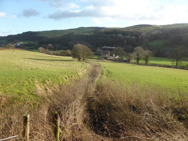
Deheufryn Gorse is a vast expanse of gorse-covered land situated in Denbighshire, Wales. It is nestled within the picturesque countryside, offering breathtaking views of the surrounding hills and valleys. The area is primarily characterized by its rugged terrain, consisting of downs and moorland.

Covering an extensive area, Deheufryn Gorse is home to a diverse range of flora and fauna. The gorse, a spiny evergreen shrub, dominates the landscape with its vibrant yellow flowers, especially during the spring and summer months. This creates a striking contrast against the backdrop of the greenery and heather.

The downs in Deheufryn Gorse are gently rolling hills that provide an ideal habitat for a variety of bird species, including skylarks and meadow pipits. The moorland, on the other hand, is characterized by open expanses of heather, bracken, and grasses, which attract a multitude of insects and small mammals.

The area is a haven for outdoor enthusiasts and nature lovers, offering numerous walking trails and paths for exploration. Visitors can enjoy leisurely strolls while immersing themselves in the tranquility of the natural surroundings. The breathtaking views from the higher points of the downs offer a sense of serenity and solitude.

Deheufryn Gorse is an important conservation area, as it provides a sanctuary for many rare and endangered species. The management of the land focuses on preserving and enhancing the natural habitat, ensuring the long-term sustainability of the area.

Overall, Deheufryn Gorse in Denbighshire is a remarkable landscape that showcases the beauty of the Welsh countryside. With its diverse flora and fauna, it offers a unique and enriching experience for all who visit.

If you have any feedback on the listing, please let us know in the comments section below.

Deheufryn Gorse Images

Images are sourced within 2km of 53.225943/-3.6894016 or Grid Reference SH8771. Thanks to Geograph Open Source API. All images are credited.

Fields near the A548
Empty feeding trough
Feed store at Bodgynwch
Afon Elwy
Afon Elwy
The River Elwy The River Elwy is a tributary of the River Clwyd. The source of the river is sometimes said to be on the northern flank of Moel Seisiog, south-east of Llanrwst. However the river is only actually called the Elwy at the village of Llangernyw, where three rivers, Afon Cledwen, Afon Collen and Afon Gallen, meet to form the Elwy. After flowing eastwards through Llanfair Talhaearn and then Bontnewydd, the river turns northwards again and flows through St. Asaph. It joins the River Clwyd about half way between St. Asaph and Rhuddlan.
The River Elwy
The River Elwy is a tributary of the River Clwyd. The source of the river is sometimes said to be on the northern flank of Moel Seisiog, south-east of Llanrwst. However the river is only actually called the Elwy at the village of Llangernyw, where three rivers, Afon Cledwen, Afon Collen and Afon Gallen, meet to form the Elwy. After flowing eastwards through Llanfair Talhaearn and then Bontnewydd, the river turns northwards again and flows through St. Asaph. It joins the River Clwyd about half way between St. Asaph and Rhuddlan.
Fields at Tan-y-Graig The farm road runs along a wooded bank above pasture.
Fields at Tan-y-Graig
The farm road runs along a wooded bank above pasture.
Cottage and hill A lone cottage and sheds perched on the hillside near to Llanfair TH
Cottage and hill
A lone cottage and sheds perched on the hillside near to Llanfair TH
Tollgate Cottage West of Llanfair Talhaiarn on the A548
Tollgate Cottage
West of Llanfair Talhaiarn on the A548
Gell fields
Gell fields
The A548 near Pentre Isaf
Bryn-yr-Aur For Sale
Above the byway to Pant-y-clyd Taken from the western slopes of Moelfre Uchaf, the byway to Pant-y-clyd lies inconveniently on the other side of the fence seen lower left of the photograph (inconvenient only for the photographer seeking the shortest and most legal way back to the road to the south). The byway crosses and climbs out of the valley ahead, to traverse the slopes on the right of the photo. The valley itself drops away to Glyn Bâch and down to a small reservoir hidden in the woodland, from which there had earlier come an unaccountably loud sound of machinery. The fields on the horizon occupy the northeastern slopes of Mynydd Branar.
Above the byway to Pant-y-clyd
Taken from the western slopes of Moelfre Uchaf, the byway to Pant-y-clyd lies inconveniently on the other side of the fence seen lower left of the photograph (inconvenient only for the photographer seeking the shortest and most legal way back to the road to the south). The byway crosses and climbs out of the valley ahead, to traverse the slopes on the right of the photo. The valley itself drops away to Glyn Bâch and down to a small reservoir hidden in the woodland, from which there had earlier come an unaccountably loud sound of machinery. The fields on the horizon occupy the northeastern slopes of Mynydd Branar.
View towards Glyn Bach Looking over upland sheep pasture towards the wooded glyn.
View towards Glyn Bach
Looking over upland sheep pasture towards the wooded glyn.
Track to Cil-llidiart A deceptively respectable track, nominally "open to all traffic" but which degrades very quickly and would be impassible in winter.
Track to Cil-llidiart
A deceptively respectable track, nominally "open to all traffic" but which degrades very quickly and would be impassible in winter.
Ancient wall and hedge Following the old track to Cil-llidiart, where ancient walls have fallen and become overgrown, while the hedge has become a row of sporadic, mature hawthorn trees.
Ancient wall and hedge
Following the old track to Cil-llidiart, where ancient walls have fallen and become overgrown, while the hedge has become a row of sporadic, mature hawthorn trees.
Pasture view Looking over the remains of a roadside wall and outgrown hedge towards Mynydd Glyn-Lws.
Pasture view
Looking over the remains of a roadside wall and outgrown hedge towards Mynydd Glyn-Lws.
Moelfre Uchaf Lower slopes of Moelfre Uchaf leading down to the valley.
Moelfre Uchaf
Lower slopes of Moelfre Uchaf leading down to the valley.
Farm pond A small pond on the farmland in the hills near Mynydd Brana
Farm pond
A small pond on the farmland in the hills near Mynydd Brana
Show me another place!

Deheufryn Gorse is located at Grid Ref: SH8771 (Lat: 53.225943, Lng: -3.6894016)

Unitary Authority: Conwy

Police Authority: North Wales

What 3 Words

///agents.truly.shadowing. Near Llysfaen, Conwy

Related Wikis

St John's Church, Trofarth

St John's Church, Trofarth, is a redundant church standing in an isolated position in Conwy County Borough, Wales (grid reference SH857718). It was designated...

Moelfre Uchaf

Moelfre Uchaf is a hill in the borough of Conwy, North Wales, 5 miles (8.0 km) south-east of Colwyn Bay and 1.5 mi (2.4 km) south-west of Betws-yn-Rhos...

Llyn Ty'n y Llyn

Llyn Ty'n y Llyn is a Site of Special Scientific Interest in the preserved county of Clwyd, north Wales. == See also == List of Sites of Special Scientific...

Coed Coch

Coed Coch, in Dolwen, Conwy, Wales, is a large 19th-century mansion in the neoclassical style, designed by the architect Henry Hakewill. The building...

Nearby Amenities

Located within 500m of 53.225943,-3.6894016
Power: tower
Lat/Long: 53.2247691/-3.6874456
Power: tower
Lat/Long: 53.2248322/-3.682575
Power: tower
Lat/Long: 53.2247061/-3.6957521
Power: tower
Lat/Long: 53.2247286/-3.6921136
Direction: 190
Generator Method: photovoltaic
Generator Output Electricity: yes
Generator Solar Modules: 16
Generator Source: solar
Generator Type: solar_photovoltaic_panel
Location: roof
Power: generator
Lat/Long: 53.2255677/-3.695624
The data included in this document is from www.openstreetmap.org. The data is made available under ODbL.

Have you been to Deheufryn Gorse?

Leave your review of Deheufryn Gorse below (or comments, questions and feedback).