Gearraidhean an Tairneanaich

Downs, Moorland in Ross-shire

Scotland

Gearraidhean an Tairneanaich

Moorland south of Cnoc an t-Sid Mor This area has been fenced, dug and planted with young native trees.
Moorland south of Cnoc an t-Sid Mor Credit: Dorothy Carse

Gearraidhean an Tairneanaich, located in Ross-shire, Scotland, is a region known for its stunning downs and moorlands. Spanning over a vast expanse of approximately 200 square kilometers, this area offers breathtaking landscapes and a diverse range of flora and fauna.

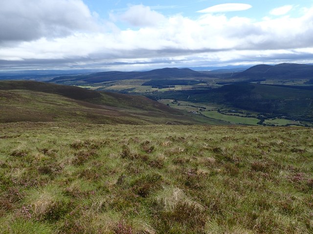
The downs of Gearraidhean an Tairneanaich are characterized by their gently rolling hills and expansive grasslands. These downs provide a picturesque backdrop, with their vibrant green hues that change with the seasons. The area is dotted with small lochs, adding to its natural beauty.

The moorlands in Gearraidhean an Tairneanaich are a sight to behold. They are characterized by their vast expanses of heather, creating a carpet of purple hues during the summer months. This habitat is home to a variety of bird species, including the iconic red grouse, which is native to the Scottish moorlands.

The region is also known for its rich history and heritage. Ruins of ancient settlements can be found scattered across the downs and moorlands, providing a glimpse into the area's past. Visitors can explore these historic sites and learn about the people who once inhabited this land.

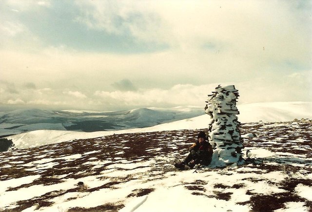
Outdoor enthusiasts are drawn to Gearraidhean an Tairneanaich for its excellent opportunities for hiking, birdwatching, and photography. The network of trails offers stunning panoramic views of the downs and moorlands, making it a haven for nature lovers and photographers alike.

In conclusion, Gearraidhean an Tairneanaich in Ross-shire is a captivating region renowned for its downs and moorlands. Its breathtaking landscapes, rich history, and abundant wildlife make it a must-visit destination for those seeking to immerse themselves in the beauty of Scotland's natural wonders.

If you have any feedback on the listing, please let us know in the comments section below.

Gearraidhean an Tairneanaich Images

Images are sourced within 2km of 57.769443/-4.3507843 or Grid Reference NH6077. Thanks to Geograph Open Source API. All images are credited.

Moorland south of Cnoc an t-Sid Mor This area has been fenced, dug and planted with young native trees.
Moorland south of Cnoc an t-Sid Mor
This area has been fenced, dug and planted with young native trees.
Above Cor Tollie Rough heather, just out in flower, and tussocky grass between Beinn Tharsuinn and Cnoc an t-Sidhein Mor.
Above Cor Tollie
Rough heather, just out in flower, and tussocky grass between Beinn Tharsuinn and Cnoc an t-Sidhein Mor.
Rocks on NW Slopes of Cnoc a' Mhadaidh Short heather just in flower made for very pleasant walking. Carn Chuinneag in the distance.
Rocks on NW Slopes of Cnoc a' Mhadaidh
Short heather just in flower made for very pleasant walking. Carn Chuinneag in the distance.
Cairn on Cnoc an t-Sidhein Mor Cairn was built cleverly on a rock. The long ridge is visible behind.
Cairn on Cnoc an t-Sidhein Mor
Cairn was built cleverly on a rock. The long ridge is visible behind.
SW Slopes of Cnoc a' Mhadaidh Rough grass and heather slopes, leading down into Strath Rusdale.
SW Slopes of Cnoc a' Mhadaidh
Rough grass and heather slopes, leading down into Strath Rusdale.
Heather slope on Torr Leathann Torr Leathann is a subsidiary top of Beinn Tharsuinn; this slope is on its rounded north-eastern ridge. The wind turbines on the distant hills are those of the Beinn Tharsuinn Wind Farm.
Heather slope on Torr Leathann
Torr Leathann is a subsidiary top of Beinn Tharsuinn; this slope is on its rounded north-eastern ridge. The wind turbines on the distant hills are those of the Beinn Tharsuinn Wind Farm.
Snow in peat hagg on Beinn Tharsuinn Residual snow in a peat hagg close to the summit of Beinn Tharsuinn. Torr Leathann is the hill beyond the col.
Snow in peat hagg on Beinn Tharsuinn
Residual snow in a peat hagg close to the summit of Beinn Tharsuinn. Torr Leathann is the hill beyond the col.
Col between Beinn Tharsuinn and Torr Leathann Torr Leathann is the mountain beyond the col; Beinn Tharsuinn lies higher, behind the camera position.
Col between Beinn Tharsuinn and Torr Leathann
Torr Leathann is the mountain beyond the col; Beinn Tharsuinn lies higher, behind the camera position.
Beinn Tharsuinn: Cnoc an t-Sidhean Mòr The flat top of Cnoc an t-Sidhean Mòr, with a view towards the higher part of Beinn Tharsuinn.
Beinn Tharsuinn: Cnoc an t-Sidhean Mòr
The flat top of Cnoc an t-Sidhean Mòr, with a view towards the higher part of Beinn Tharsuinn.
Beinn Tharsuinn: Cnoc an t-Sidhean Mòr The northern end of a long summit plateau. There is little peat here, but as soon as there is any shelter, the ground gets boggy.
Beinn Tharsuinn: Cnoc an t-Sidhean Mòr
The northern end of a long summit plateau. There is little peat here, but as soon as there is any shelter, the ground gets boggy.
Beinn Tarsuinn: Col below  Cnoc an t-Sidhean Mòr Very boggy col with the drier Cnoc an t-Sidhean Mòr in the background.
Beinn Tarsuinn: Col below Cnoc an t-Sidhean Mòr
Very boggy col with the drier Cnoc an t-Sidhean Mòr in the background.
Summit cairn on Cnoc an t-Sidhein Mor Unusual cairn on top of Glacial boulder with Beinn Tharsuinn in background
Summit cairn on Cnoc an t-Sidhein Mor
Unusual cairn on top of Glacial boulder with Beinn Tharsuinn in background
Col  on Cnoc an t-Sidhein Mor Boggy head waters of the burn on top of the col.
Col on Cnoc an t-Sidhein Mor
Boggy head waters of the burn on top of the col.
Sheltering from the wind on Beinn Tharsuinn
Snow filled peat hag on the flank of Beinn Tharsuinn Here a peat hag has provided protection from the wind thereby ensuring the survival of snow after it has melted on the surrounding slopes.
Snow filled peat hag on the flank of Beinn Tharsuinn
Here a peat hag has provided protection from the wind thereby ensuring the survival of snow after it has melted on the surrounding slopes.
Summit cairn, Torr Leathann
Summit of Torr Leathann
Summit of Beinn Tharsuinn
Show me another place!

Gearraidhean an Tairneanaich is located at Grid Ref: NH6077 (Lat: 57.769443, Lng: -4.3507843)

Unitary Authority: Highland

Police Authority: Highlands and Islands

What 3 Words

///heap.dragons.reinvest. Near Alness, Highland

Related Wikis

Strathrusdale

Strathrusdale (Brittonic or Scottish Gaelic/Old Norse Hybrid: Strath Rùsdail, Strath, [Brittonic/Gaelic] small valley, of Rusdale, rus, Norse for [male...

Ardross, Highland

Ardross (Scottish Gaelic: Àird Rois, high-point of [Easter] Ross) is a rural area in the Highland region of Scotland, 30 miles (48 km) north of the nearest...

Strathy, Ardross

Strathy (Scottish Gaelic: An t-Srathaidh, "small strath") is a strath in the Highlands of Scotland, forming the Northern part of the area known as Ardross...

B9176 road

The B9176 also known as the "Struie" is a 15-mile-long (24 km) road from Alness to Bonar Bridge. in the Scottish Highlands. This road is the main road...

Have you been to Gearraidhean an Tairneanaich?

Leave your review of Gearraidhean an Tairneanaich below (or comments, questions and feedback).