Dundreggan Forest

Downs, Moorland in Inverness-shire

Scotland

Dundreggan Forest

Summit of Carn Mhic an Toisich The summit of this hill is marked by a stone cairn. At 678m, it is listed as a Graham and a Marilyn.

The moorland below has several small lochs, including Loch nan Eun, Loch Liath and Loch ma Stac. Corrimony wind farm is visible in the distance.
Summit of Carn Mhic an Toisich Credit: Craig Wallace

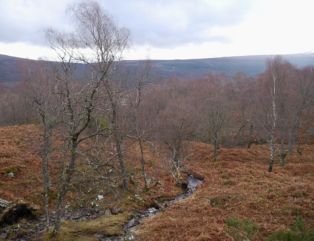
Dundreggan Forest is a captivating natural wonder nestled in the heart of Inverness-shire, Scotland. Situated on the eastern slopes of the Glen Moriston valley, this expansive forest spans over 10,000 acres of diverse landscapes, including downs and moorland.

The forest boasts an abundance of native tree species, including Scots pine, birch, rowan, and juniper, which create a lush, green canopy that stretches as far as the eye can see. These trees provide a habitat for a wide range of wildlife, such as red deer, pine martens, and a variety of bird species, making Dundreggan Forest a haven for nature enthusiasts and photographers alike.

The downs of Dundreggan Forest offer breathtaking panoramic views of the surrounding countryside, with rolling hills and open grasslands as far as the eye can see. This vast expanse of open space provides opportunities for hiking, picnicking, and enjoying the tranquility of the Scottish Highlands.

The moorland areas within Dundreggan Forest are characterized by their unique vegetation, including heather, cotton grass, and bog moss. These wetland ecosystems host a plethora of rare plant species, adding to the rich biodiversity of the area. It also provides a critical habitat for various bird species, such as curlew and golden plover, which thrive in this unique environment.

Managed by the conservation charity Trees for Life, Dundreggan Forest is not only a picturesque destination but also a place of active ecological restoration. Through tree planting, deer management, and habitat restoration projects, the forest is being nurtured back to its former glory, ensuring its sustainability for future generations to enjoy.

If you have any feedback on the listing, please let us know in the comments section below.

Dundreggan Forest Images

Images are sourced within 2km of 57.210463/-4.7862544 or Grid Reference NH3116. Thanks to Geograph Open Source API. All images are credited.

Summit of Carn Mhic an Toisich The summit of this hill is marked by a stone cairn. At 678m, it is listed as a Graham and a Marilyn.

The moorland below has several small lochs, including Loch nan Eun, Loch Liath and Loch ma Stac. Corrimony wind farm is visible in the distance.
Summit of Carn Mhic an Toisich
The summit of this hill is marked by a stone cairn. At 678m, it is listed as a Graham and a Marilyn. The moorland below has several small lochs, including Loch nan Eun, Loch Liath and Loch ma Stac. Corrimony wind farm is visible in the distance.
Slopes of An Suidhe and Carn Mhic an Toisich Looking along the side of this ridge.
Most of the area is moorland, with plenty of heather, grass and bog cotton. The ground was all rather dry today.
Slopes of An Suidhe and Carn Mhic an Toisich
Looking along the side of this ridge. Most of the area is moorland, with plenty of heather, grass and bog cotton. The ground was all rather dry today.
Tributary of the Allt Iarairidh This burn flows down through heather moorland, on the lower slopes of Carn Mhic an Toisich and Carn Dubh. The burn is rather rocky with some small pools, not much water flowing down today.
Tributary of the Allt Iarairidh
This burn flows down through heather moorland, on the lower slopes of Carn Mhic an Toisich and Carn Dubh. The burn is rather rocky with some small pools, not much water flowing down today.
Birch woodland, on the slopes of Binnilidh Bheag A small stream running through woodland on the hills above Dundreggan. Much of this woodland is birch trees, along with some aspen, Scots pine, juniper and plenty of bracken.
Birch woodland, on the slopes of Binnilidh Bheag
A small stream running through woodland on the hills above Dundreggan. Much of this woodland is birch trees, along with some aspen, Scots pine, juniper and plenty of bracken.
Wood ants, Dundreggan A close look at an ants nest. The nest is a mound covered by pine needles, twigs and moss, with plenty of ants busy crawling around. There are quite a few ant nests in the woodland around Dundreggan.

These are probably Northern wood ant (Formica lugubris) or Scottish wood ant (Formica aquilonia) - both species occur in pine forest around the highlands.
Wood ants, Dundreggan
A close look at an ants nest. The nest is a mound covered by pine needles, twigs and moss, with plenty of ants busy crawling around. There are quite a few ant nests in the woodland around Dundreggan. These are probably Northern wood ant (Formica lugubris) or Scottish wood ant (Formica aquilonia) - both species occur in pine forest around the highlands.
Allt Ruadh planting area, Dundreggan This area has been fenced to reduce grazing by deer, and thousands of trees have been planted within. With an information board next to the gate, and a photopost on the right.
Allt Ruadh planting area, Dundreggan
This area has been fenced to reduce grazing by deer, and thousands of trees have been planted within. With an information board next to the gate, and a photopost on the right.
Allt Ruadh planting area, Dundreggan A view from the photopost, looking through the fence.
Allt Ruadh planting area, Dundreggan
A view from the photopost, looking through the fence.
Woodland, Dundreggan A view from the photopost.
Mixed woodland, including Scots pine, birch, juniper and bracken. A track heading down the hill.
Woodland, Dundreggan
A view from the photopost. Mixed woodland, including Scots pine, birch, juniper and bracken. A track heading down the hill.
Pool, Dundreggan A small pool on moorland above Dundreggan, with a few juniper bushes. A view across Glen Moriston.
Pool, Dundreggan
A small pool on moorland above Dundreggan, with a few juniper bushes. A view across Glen Moriston.
Slopes of Binnilidh Mhòr Rough heather and grass, with a few scattered trees.
Slopes of Binnilidh Mhòr
Rough heather and grass, with a few scattered trees.
Slopes of Binnilidh Mhòr Rough heather and grass, with a few scattered trees.
Slopes of Binnilidh Mhòr
Rough heather and grass, with a few scattered trees.
On Binnilidh Mhòr Looking towards the main summit. Rough moorland, with a few rocky outcrops.
On Binnilidh Mhòr
Looking towards the main summit. Rough moorland, with a few rocky outcrops.
View of Bhlaraidh Wind Farm A view from Binnilidh Mhòr, looking across the valley of the Allt Iarairaidh.
View of Bhlaraidh Wind Farm
A view from Binnilidh Mhòr, looking across the valley of the Allt Iarairaidh.
Woodland, Dundreggan A view from the same photopost, a few months later. <a href="https://www.geograph.org.uk/photo/7466789">NH3215 : Woodland, Dundreggan</a>
Now more leaves on the trees, and plenty of bracken growing.
Woodland, Dundreggan
A view from the same photopost, a few months later. NH3215 : Woodland, Dundreggan Now more leaves on the trees, and plenty of bracken growing.
Woodland path, Dundreggan Heading up the hill, past some large birch trees and plenty of bracken.
Woodland path, Dundreggan
Heading up the hill, past some large birch trees and plenty of bracken.
Carn Mhic an Toisich The summit with a turfed over cairn. There is no sign of wear from visitors, this is not a popular hill. The view includes Loch Liath (left) and Loch Ness (right)
Carn Mhic an Toisich
The summit with a turfed over cairn. There is no sign of wear from visitors, this is not a popular hill. The view includes Loch Liath (left) and Loch Ness (right)
Southern slopes of Carn Mhic an Toisich View down moorland slopes and across Glen Morriston to the power station construction site east of Meall Dubh.
Southern slopes of Carn Mhic an Toisich
View down moorland slopes and across Glen Morriston to the power station construction site east of Meall Dubh.
Col between Carn Mhic an Toisich and Carn na Caorach A boggy area of moorland with Carn na Caorach in the background.
Col between Carn Mhic an Toisich and Carn na Caorach
A boggy area of moorland with Carn na Caorach in the background.
Show me another place!

Dundreggan Forest is located at Grid Ref: NH3116 (Lat: 57.210463, Lng: -4.7862544)

Unitary Authority: Highland

Police Authority: Highlands and Islands

What 3 Words

///hill.tadpole.stream. Near Cannich, Highland

Related Wikis

Loch a' Bhainne

Loch a' Bhainne is a small, upland freshwater loch approximately 2 miles (3.2 km) north of the east end of Loch Garry and 3.5 miles (5.6 km) north-west...

Glenmoriston

Glenmoriston or Glen Moriston (Scottish Gaelic: Gleann Moireasdan) is a river glen in the Scottish Highlands, that runs from Loch Ness, at the village...

Dalchreichart

Dalchreichart (Scottish Gaelic: Dul Chreachaird) is a small hamlet in Glen Moriston, Inverness-shire, in the Highland council area of Scotland. It lies...

Achlain

Achlain is a house in Glenmoriston in the Highland council area of Scotland. It is about 15 km west of Invermoriston, next to the A887 road and the River...

Nearby Amenities

Located within 500m of 57.210463,-4.7862544
Carnis Mhor
Natural: peak
Lat/Long: 57.2104422/-4.7851854
Dundreggan Forest
Natural: wood
Lat/Long: 57.2091/-4.7851317
The data included in this document is from www.openstreetmap.org. The data is made available under ODbL.

Have you been to Dundreggan Forest?

Leave your review of Dundreggan Forest below (or comments, questions and feedback).