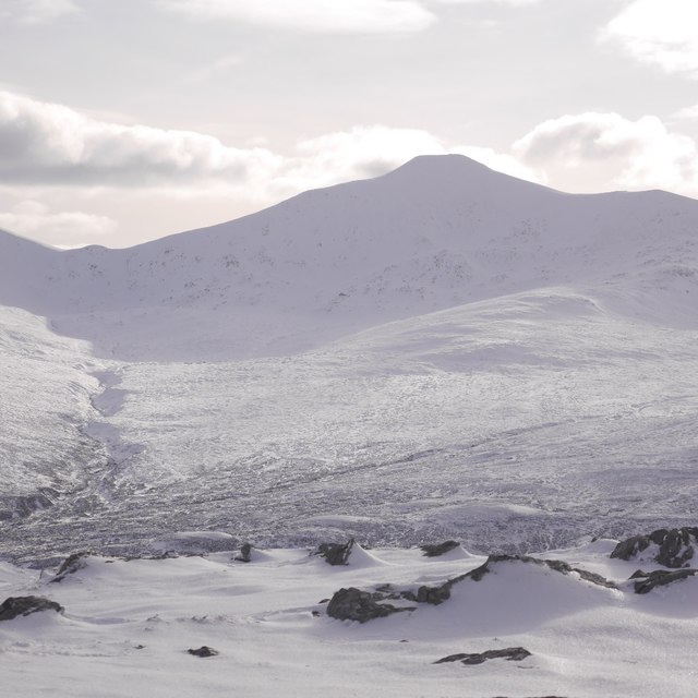
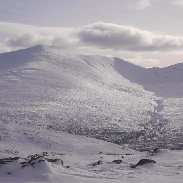
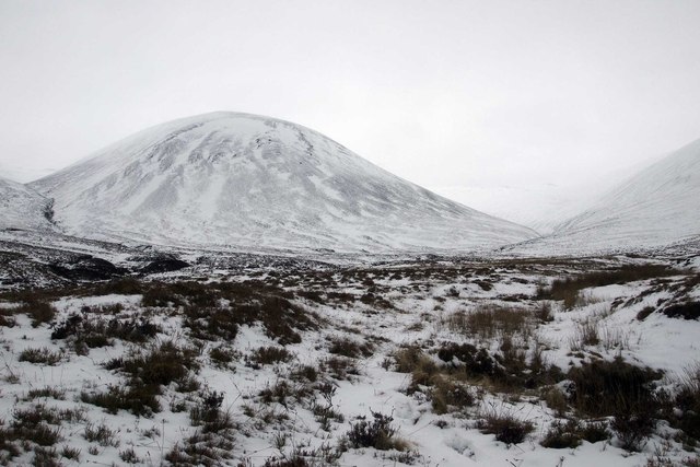
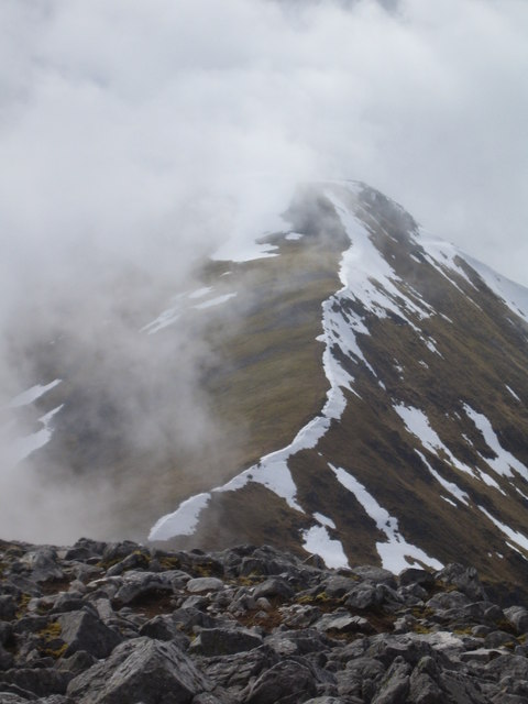
Sliabhach

Downs, Moorland in Inverness-shire

Scotland

Sliabhach

Sgùrr a' Choire Ghlais The highest of the hills around Glen Orrin, seen across the glen from Beinn Mheadhoin.
Sgùrr a' Choire Ghlais Credit: Richard Webb

The requested URL returned error: 429 Too Many Requests

If you have any feedback on the listing, please let us know in the comments section below.

Sliabhach Images

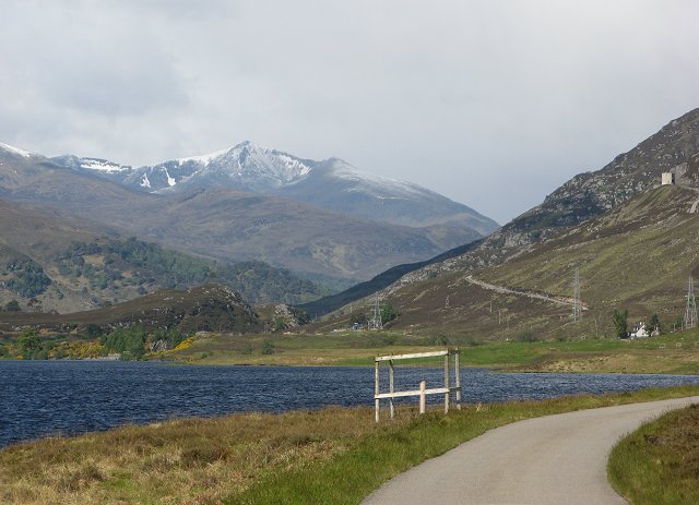
Images are sourced within 2km of 57.445103/-4.872961 or Grid Reference NH2743. Thanks to Geograph Open Source API. All images are credited.

Sgùrr a' Choire Ghlais The highest of the hills around Glen Orrin, seen across the glen from Beinn Mheadhoin.
Sgùrr a' Choire Ghlais
The highest of the hills around Glen Orrin, seen across the glen from Beinn Mheadhoin.
Glen Orrin hills, Bealach Sneachda Two of the big hills at the head of Glen Orrin and the Bealach Sneachda between them seen across the glen from Beinn Mheadhoin.  Carn nan Gobhar (left) and Sgùrr a' Choire Ghlais (right).
Glen Orrin hills, Bealach Sneachda
Two of the big hills at the head of Glen Orrin and the Bealach Sneachda between them seen across the glen from Beinn Mheadhoin. Carn nan Gobhar (left) and Sgùrr a' Choire Ghlais (right).
Coire an Each on Carn nan Gobhar A corrie on the northeast side of Carn nan Gobhar, Glen Orrin.   Carn na Gobhar is one of a string of high summits between Glen Orrin and Glen Strathfarrar on the Ross and Cromarty/Inverness-shire march.
Coire an Each on Carn nan Gobhar
A corrie on the northeast side of Carn nan Gobhar, Glen Orrin. Carn na Gobhar is one of a string of high summits between Glen Orrin and Glen Strathfarrar on the Ross and Cromarty/Inverness-shire march.
Carn nan Gobhar One of the high summits between Glen Strathfarrar and Glen Orrin.  View across Glen Orrin from Beinn Mheadhoin.
Carn nan Gobhar
One of the high summits between Glen Strathfarrar and Glen Orrin. View across Glen Orrin from Beinn Mheadhoin.
Sgurr a' Choire Ghlais Coming off the grassy slopes of Carn nan Gobhar, heading for Sgurr a' Choire Ghlais.
Sgurr a' Choire Ghlais
Coming off the grassy slopes of Carn nan Gobhar, heading for Sgurr a' Choire Ghlais.
Coire Mhuillidh looking at An Socach An Socach of Carn nan Gobhar, Strathfarrar, seen from Coire Mhuillidh floor.
Coire Mhuillidh looking at An Socach
An Socach of Carn nan Gobhar, Strathfarrar, seen from Coire Mhuillidh floor.
Carn nan Gobhar summit cairn Sgurr a' Choire Ghlais, Creag Ghorm a' Bhealaich and Sgurr Fhuar-thuill from this 992m summit, one of the four Strathfarrar Munros.
Carn nan Gobhar summit cairn
Sgurr a' Choire Ghlais, Creag Ghorm a' Bhealaich and Sgurr Fhuar-thuill from this 992m summit, one of the four Strathfarrar Munros.
Summit cairn, Sgurr na Ruaidhe, Strathfarrar Westwards to Sgurr a' Choire Ghlais. It's interesting to see that the snow cover here in June '86 is comparable to that in April '07 shown in <a href="https://www.geograph.org.uk/photo/432810">NH2842 : Sgurr na Ruaidhe - Summit Cairn</a>.
Summit cairn, Sgurr na Ruaidhe, Strathfarrar
Westwards to Sgurr a' Choire Ghlais. It's interesting to see that the snow cover here in June '86 is comparable to that in April '07 shown in NH2842 : Sgurr na Ruaidhe - Summit Cairn.
Not Quite the Summit Little stone shelter a few hundred metres from the summit of Sgurr na Ruaidhe north of Glen Strathfarrar. In the centre is Sgurr a' Choire Ghlais the highest summit of the 4 Strathfarrar Munros.
Not Quite the Summit
Little stone shelter a few hundred metres from the summit of Sgurr na Ruaidhe north of Glen Strathfarrar. In the centre is Sgurr a' Choire Ghlais the highest summit of the 4 Strathfarrar Munros.
Sgurr a' Choire Ghlais Sgurr a' Choire Ghlais seen from just above the Bealach Sneachda, with the last peak of the day Sgurr Fhuar-thuill also seen to the right - a grand day on the Farrar 4.
Sgurr a' Choire Ghlais
Sgurr a' Choire Ghlais seen from just above the Bealach Sneachda, with the last peak of the day Sgurr Fhuar-thuill also seen to the right - a grand day on the Farrar 4.
Trig Point on Summit of Sgurr a Choire Glais Taken from the cairn at the N end of the summit plateau the trig point is just left of centre standing amidst snow.  The lump to the right is another cairn.
Trig Point on Summit of Sgurr a Choire Glais
Taken from the cairn at the N end of the summit plateau the trig point is just left of centre standing amidst snow. The lump to the right is another cairn.
Stony summit of Carn nan Gobhar
Tundra-like Summit plateau of Sgurr na Ruaidhe Amidst the rocks and short grass this ptarmigan is fantastically camouflaged.
Tundra-like Summit plateau of Sgurr na Ruaidhe
Amidst the rocks and short grass this ptarmigan is fantastically camouflaged.
The North East Ridge of Sgurr a Choire Ghlais The very top of the ridge is in the next grid square, but most of this graceful sweep is in <a href="https://www.geograph.org.uk/gridref/NH2643">NH2643</a>.
The North East Ridge of Sgurr a Choire Ghlais
The very top of the ridge is in the next grid square, but most of this graceful sweep is in NH2643.
North ridge of Sgurr na Ruaidhe Sgurr na Ruaidhe is a moss covered hill with gentle contours. It is nearly always climbed from the Glen Strathfarrar in the south, but the Stathconon Estate's bridges make an approach from Strathconon perfectly feasible (at time of writing, the bridges may not always be intact), and this gets around the vehicle access issues on the Strathfarrar road. 
Taken in sleet and strong winds. I was not adequately clothed for the conditions and had by now decided to return to Glen Orrin as soon as I had reached the summit, rather than explore the tops to the east as planned.
North ridge of Sgurr na Ruaidhe
Sgurr na Ruaidhe is a moss covered hill with gentle contours. It is nearly always climbed from the Glen Strathfarrar in the south, but the Stathconon Estate's bridges make an approach from Strathconon perfectly feasible (at time of writing, the bridges may not always be intact), and this gets around the vehicle access issues on the Strathfarrar road. Taken in sleet and strong winds. I was not adequately clothed for the conditions and had by now decided to return to Glen Orrin as soon as I had reached the summit, rather than explore the tops to the east as planned.
Bealach nam Botaichean and Carn nan Gobhar Pass between Carn nan Gobhar (the background hill) and Sgurr na Ruaidhe  at the head of Coire na Sleaghaich.
These hills are normally done as a ridge walk over six summits from the south, the northern ridges running to Glen Orrin being quite long.

Both Carn nan Gobhar and Sgurr Ruaidhe are mossy hills with thin soils.

There is a misprint on the 1:50 000 map. "Shabhach" should read Sliabhach.
Bealach nam Botaichean and Carn nan Gobhar
Pass between Carn nan Gobhar (the background hill) and Sgurr na Ruaidhe at the head of Coire na Sleaghaich. These hills are normally done as a ridge walk over six summits from the south, the northern ridges running to Glen Orrin being quite long. Both Carn nan Gobhar and Sgurr Ruaidhe are mossy hills with thin soils. There is a misprint on the 1:50 000 map. "Shabhach" should read Sliabhach.
Summit, Sgurr na Ruaidhe The cairn on what is remarkably unworn ground for a 3000' summit. Sgurr na Ruaidhe has little soil on its high ground, and is covered in moss. 

That was far enough south for today, it's a long way back to Strathconon, and I was feeling dangerously cold.  There was a handy wind shelter below the cairn for taking bearings and eating in.
Summit, Sgurr na Ruaidhe
The cairn on what is remarkably unworn ground for a 3000' summit. Sgurr na Ruaidhe has little soil on its high ground, and is covered in moss. That was far enough south for today, it's a long way back to Strathconon, and I was feeling dangerously cold. There was a handy wind shelter below the cairn for taking bearings and eating in.
Sgurr na Ruaidhe: more tundra The northeast part of the summit plateau of Sgurr na Ruaidhe. Miles of fast going on mossy ground.  I was moving fast, trying to get down out of the wind and rain. Clear spells kept passing, but by the time I got the camera out, the cloud was back.

Looking towards the partially hidden 913m Aonach na Reise.
Sgurr na Ruaidhe: more tundra
The northeast part of the summit plateau of Sgurr na Ruaidhe. Miles of fast going on mossy ground. I was moving fast, trying to get down out of the wind and rain. Clear spells kept passing, but by the time I got the camera out, the cloud was back. Looking towards the partially hidden 913m Aonach na Reise.
Show me another place!

Sliabhach is located at Grid Ref: NH2743 (Lat: 57.445103, Lng: -4.872961)

Unitary Authority: Highland

Police Authority: Highlands and Islands

What 3 Words

///panther.caveman.glossed. Near Cannich, Highland

Nearby Locations

Carn nan Gobhar Sliabhach

Related Wikis

Càrn nan Gobhar (Strathfarrar)

Càrn nan Gobhar is a mountain rising to 992 metres (3,255 ft) in the Northwest Highlands of Scotland. It lies north of Glen Strathfarrar and south of Glen...

Sgùrr a' Choire Ghlais

Sgurr a' Choire Ghlais is a mountain in the North-west Highlands of Scotland. It lies between Glen Strathfarrar and Glen Orrin and it is an excellent viewpoint...

Glen Strathfarrar

Glen Strathfarrar (Scottish Gaelic: Srath Farair) is a glen in the Highland region of Scotland, near Loch Ness. The Glen is part of the Affric-Beauly hydro...

Loch Beannacharan

Loch Beannacharan is a freshwater loch in Glen Strathfarrar, situated roughly 9.5 kilometres (5.9 mi) west of the village of Struy. The loch sits on the...

Have you been to Sliabhach?

Leave your review of Sliabhach below (or comments, questions and feedback).