The Moss

Downs, Moorland in Argyllshire

Scotland

The Moss

The River Bà above Bà Bridge The mountains of the southern Blackmount form the backdrop, with Stob a' Choire Odhair on the left.
The River Bà above Bà Bridge Credit: Nigel Brown

The Moss in Argyllshire, Scotland, is a vast expanse of downs and moorland that offers a diverse landscape with its unique features. Spanning over a considerable area, it is located in the heart of Argyllshire and is a popular destination for nature enthusiasts and outdoor adventurers alike.

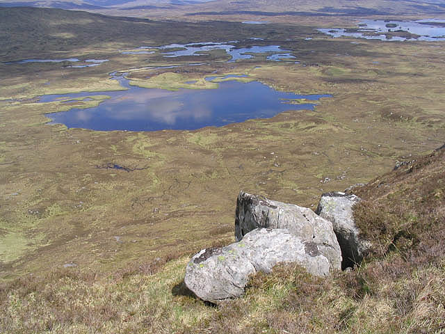
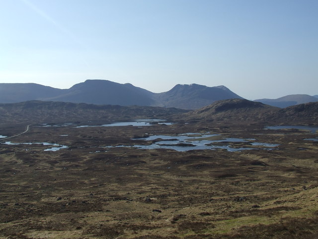
The Moss is characterized by its undulating downs, covered in a thick carpet of vibrant green mosses, hence its name. These mosses create a soft and cushiony terrain, making it a pleasant experience for hikers and walkers. The landscape is dotted with wildflowers, adding bursts of color to the scenery.

The moorland section of The Moss is a sight to behold, with its vast expanses of heather and gorse. In late summer, the moorland erupts in a riot of purples and yellows as the heather and gorse bloom, creating a breathtaking spectacle. The moorland is home to a variety of wildlife, including red deer, rabbits, and various bird species, making it a haven for nature lovers and birdwatchers.

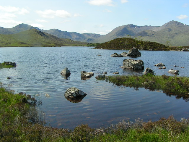
The Moss offers numerous walking trails, providing visitors with the opportunity to explore the diverse flora and fauna. The terrain is generally easy to navigate, making it accessible for all ages and fitness levels. From rolling hills to serene lochs, The Moss offers captivating views at every turn.

Overall, The Moss in Argyllshire is a haven of natural beauty and tranquility, attracting visitors from far and wide who seek to immerse themselves in the stunning Scottish countryside. Whether it's a leisurely stroll or an adventurous hike, The Moss offers a captivating experience for all who venture into its scenic embrace.

If you have any feedback on the listing, please let us know in the comments section below.

The Moss Images

Images are sourced within 2km of 56.588237/-4.8087045 or Grid Reference NN2747. Thanks to Geograph Open Source API. All images are credited.

The River Bà above Bà Bridge The mountains of the southern Blackmount form the backdrop, with Stob a' Choire Odhair on the left.
The River Bà above Bà Bridge
The mountains of the southern Blackmount form the backdrop, with Stob a' Choire Odhair on the left.
The Moss, south of Bà Bridge Typical rough and fairly damp moorland. Beinn Achaladair is the mountain on the skyline on the left, with Beinn an Dòthaidh to its right.
The Moss, south of Bà Bridge
Typical rough and fairly damp moorland. Beinn Achaladair is the mountain on the skyline on the left, with Beinn an Dòthaidh to its right.
Clach Leathad and Meall a' Bhuiridh Viewed from West Highland Way just south of Ba Bridge.  The crags of Creag an Fhirich are prominent in this view.
Clach Leathad and Meall a' Bhuiridh
Viewed from West Highland Way just south of Ba Bridge. The crags of Creag an Fhirich are prominent in this view.
Bridge, Allt Creagan nam Meann The bridges are substantial on this track as this was once the motor road to Fort William from Glasgow. Now it is the very popular West Highland Way (and walk this stretch on a good day, you will find out why it is popular). The road closed in the 1930s.

This is also the course of Caulfeild's Military Road over the Blackmount between Kingshouse and Inveroran.
Bridge, Allt Creagan nam Meann
The bridges are substantial on this track as this was once the motor road to Fort William from Glasgow. Now it is the very popular West Highland Way (and walk this stretch on a good day, you will find out why it is popular). The road closed in the 1930s. This is also the course of Caulfeild's Military Road over the Blackmount between Kingshouse and Inveroran.
Bà basin, Black Mount Lochans on Rannoch Moor (Lochan Mhic Pheadair Ruaidh and neighbours) on the route of the old road to Glencoe. The West Highland Way and the earlier Caulfeild military road use this route as well.
Bà basin, Black Mount
Lochans on Rannoch Moor (Lochan Mhic Pheadair Ruaidh and neighbours) on the route of the old road to Glencoe. The West Highland Way and the earlier Caulfeild military road use this route as well.
Bà Cottage A ruin beside the Allt Creagan nam Meann, once a house just off the main road. A landmark on the West Highland Way as it runs along the western edge of Rannoch Moor.
Bà Cottage
A ruin beside the Allt Creagan nam Meann, once a house just off the main road. A landmark on the West Highland Way as it runs along the western edge of Rannoch Moor.
Rannoch Moor View from the hillside above Bà Cottage towards Glen Orchy and Beinn Dorain and neighbours.
Rannoch Moor
View from the hillside above Bà Cottage towards Glen Orchy and Beinn Dorain and neighbours.
Wood near Bà Bridge One of several woods which would once have been landmarks for travellers on the road to Glencoe but now somewhat remote with the rerouting of the road. The River Bà  is one of the furthest flung headwaters of the Tay.
Wood near Bà Bridge
One of several woods which would once have been landmarks for travellers on the road to Glencoe but now somewhat remote with the rerouting of the road. The River Bà is one of the furthest flung headwaters of the Tay.
Woodland, Bà Bridge A plantation beside the old road to Glencoe.
Woodland, Bà Bridge
A plantation beside the old road to Glencoe.
Tussock grass on Rannoch Moor Areas of this grass can be seen amongst heather and bogs on the moor.
Tussock grass on Rannoch Moor
Areas of this grass can be seen amongst heather and bogs on the moor.
River Ba Meandering through bogs on Rannoch Moor.
River Ba
Meandering through bogs on Rannoch Moor.
Lochan Mhic Pheadair Ruaidhe Not a name likely to be instantly recognised, but walkers on the West Highland Way will know it as the shallow lochan passed between Inveroran and Glencoe.
Lochan Mhic Pheadair Ruaidhe
Not a name likely to be instantly recognised, but walkers on the West Highland Way will know it as the shallow lochan passed between Inveroran and Glencoe.
River Ba from Ba Bridge Walking the West Highland Way in 2014.  Crossing the Black Mount between Inveroran and Kinlochleven on a dry but overcast day.
River Ba from Ba Bridge
Walking the West Highland Way in 2014. Crossing the Black Mount between Inveroran and Kinlochleven on a dry but overcast day.
Mountains, Black Mount
Stob a’ Choire Odhair
Passing the Black Mount on the West Highland Way
Creag an Fhiarich
Creag an Fhiarich
West Highland Way north of Victoria Bridge A small lochan by the path.
West Highland Way north of Victoria Bridge
A small lochan by the path.
Show me another place!

The Moss is located at Grid Ref: NN2747 (Lat: 56.588237, Lng: -4.8087045)

Unitary Authority: Highland

Police Authority: Highlands and Islands

What 3 Words

///attaching.grudge.albatross. Near Tyndrum, Stirling

Nearby Locations

The Moss

Related Wikis

Loch Buidhe (Rannoch Moor)

Loch Buidhe is a fresh water loch on Rannoch Moor, Argyll and Bute within Highland council area, Scotland.It is situated about 9 km (6 mi) north of Bridge...

Stob a' Choire Odhair

Stob a' Choire Odhair is a Scottish mountain situated eight kilometres north west of Bridge of Orchy on the border of the Argyll and Bute and Highland...

Lochan na Stainge

Lochan na Stainge is a fresh water loch on Rannoch Moor, Argyll and Bute within Highland council area, Scotland. == References ==

Lochan na h-Achlaise

Lochan na h-Achlaise in Scottish Loch of the Armpit, is an irregular shaped, somewhat triangular or heart shaped, freshwater loch on Rannoch Moor, Argyll...

Meall a' Bhùiridh

Meall a' Bhùiridh (IPA:[ˈmauɫ̪ˈaˈvuːɾʲɪʝ]) is a mountain on the edge of Rannoch Moor in the Highlands of Scotland. It lies near the top of Glen Coe and...

Creise

Creise (Scottish Gaelic: A' Chrèise) is a mountain summit in the Black Mount range, in the Scottish Highlands. It overlooks the northern end of Glen Etive...

Black Mount

Black Mount (also Blackmount) is a mountain range located in Argyll and Bute, Scotland. It is situated between Glen Orchy and Glen Coe. Its four Munros...

Glencoe Ski area

Glencoe Mountain Resort (previously known as The White Corries Ski Centre) is a ski area that operates on the mountain Meall a' Bhuiridh in some of the...

Have you been to The Moss?

Leave your review of The Moss below (or comments, questions and feedback).