Beinn na Moine

Downs, Moorland in Inverness-shire

Scotland

Beinn na Moine

Ford on the Forse Burn Ford where the Orbost forest road crosses the Forse Burn. The road stops immediately after the ford and becomes a footpath.
Ford on the Forse Burn Credit: John Allan

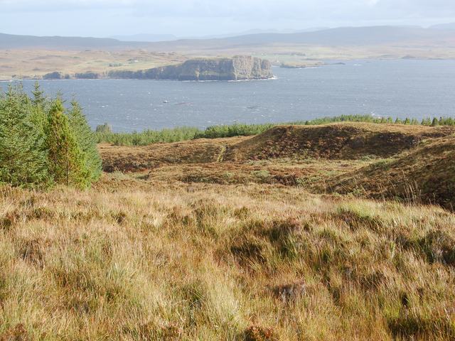
Beinn na Moine is a mountain located in Inverness-shire, Scotland. It is part of the Monadhliath mountain range and stands at a height of 875 meters (2,871 feet). The name "Beinn na Moine" translates to "Mountain of the Peat Moss" in English, reflecting the rugged and wild landscape that characterizes this area.

The mountain is known for its vast expanses of moorland, covered in heather, grasses, and peat bogs. The terrain is rocky and undulating, with steep slopes and craggy outcrops adding to the dramatic scenery. Beinn na Moine is a popular destination for hikers and outdoor enthusiasts, offering challenging terrain and stunning panoramic views of the surrounding countryside.

The area is also home to a variety of wildlife, including red deer, grouse, and birds of prey. The remote and untamed nature of Beinn na Moine makes it a haven for nature lovers and those seeking solitude in the Scottish Highlands.

Overall, Beinn na Moine is a rugged and picturesque mountain in Inverness-shire, offering a true taste of the wild beauty of the Scottish countryside.

If you have any feedback on the listing, please let us know in the comments section below.

Beinn na Moine Images

Images are sourced within 2km of 57.363817/-6.5710464 or Grid Reference NG2539. Thanks to Geograph Open Source API. All images are credited.

Ford on the Forse Burn Ford where the Orbost forest road crosses the Forse Burn. The road stops immediately after the ford and becomes a footpath.
Ford on the Forse Burn
Ford where the Orbost forest road crosses the Forse Burn. The road stops immediately after the ford and becomes a footpath.
Wall on Cnoc na Pairce A very well built dry stone wall that has survived being in the midst of a forestry plantation and has survived the felling too. Probably built as a boundary of the original Orbost House estate.
Wall on Cnoc na Pairce
A very well built dry stone wall that has survived being in the midst of a forestry plantation and has survived the felling too. Probably built as a boundary of the original Orbost House estate.
North slopes of Beinn na Moine With a view in the background across Loch Bracadale to the cliffs at Meall Greepa.
North slopes of Beinn na Moine
With a view in the background across Loch Bracadale to the cliffs at Meall Greepa.
Orbost Forest The main forest road through the community owned Orbost Forest. The flat topped hill in the distance is Beinn na Boineid.
Orbost Forest
The main forest road through the community owned Orbost Forest. The flat topped hill in the distance is Beinn na Boineid.
Loch Bracadale, Red & Black Cuillin viewed from eastern cairn on Beinn Bhac-ghlais
Forestry road, Orbost Forest Large parts of the forest have been cleared, which opens up spectacular views over Loch Bracadale.
Here, Harlosh Island is central in the picture, and Tarner Island is to its left, both lit by the winter sun. 
The distant Cuillin form an impressive backdrop.
Forestry road, Orbost Forest
Large parts of the forest have been cleared, which opens up spectacular views over Loch Bracadale. Here, Harlosh Island is central in the picture, and Tarner Island is to its left, both lit by the winter sun. The distant Cuillin form an impressive backdrop.
View over the forestry road The road runs through Orbost Forest, parts of which has been felled revealing spectacular views over Loch Bracadale.
Here, the headland in the foreground is Geodha na h-Aibhne, while the Island of Rum is clear on the horizon.
View over the forestry road
The road runs through Orbost Forest, parts of which has been felled revealing spectacular views over Loch Bracadale. Here, the headland in the foreground is Geodha na h-Aibhne, while the Island of Rum is clear on the horizon.
Orbost Forest Looking north up the forestry road from a felled part of the forest.
Wind has damaged many of the trees on the edge of the plantation.
Orbost Forest
Looking north up the forestry road from a felled part of the forest. Wind has damaged many of the trees on the edge of the plantation.
Orbost Forest Large areas of the forest have been cleared.
The water is Loch Bharcasaig, and the headland is Meall Greepa.
Orbost Forest
Large areas of the forest have been cleared. The water is Loch Bharcasaig, and the headland is Meall Greepa.
Forse Burn gorge The burn has cut a sheer-sided gorge at this point.
Forse Burn gorge
The burn has cut a sheer-sided gorge at this point.
You lookin' at me? There is something about the quizzical body language of this sheep that appeals to me. 
Maybe it has never before watched a Geograph photographer scramble thirty feet up snow covered rocks to get a picture over the top of a deer fence...

The sheep is standing at the side of the Forse Burn at the lower end of a gorge.
You lookin' at me?
There is something about the quizzical body language of this sheep that appeals to me. Maybe it has never before watched a Geograph photographer scramble thirty feet up snow covered rocks to get a picture over the top of a deer fence... The sheep is standing at the side of the Forse Burn at the lower end of a gorge.
Forest clear fell This part of Orbost Forest was cleared several years ago.
The view looks north north-east up the forestry road. Beyond, the headland of Meall Greepa stands between Loch Bharcasaig (left) and Loch Vatten.
Forest clear fell
This part of Orbost Forest was cleared several years ago. The view looks north north-east up the forestry road. Beyond, the headland of Meall Greepa stands between Loch Bharcasaig (left) and Loch Vatten.
Spectacular sky over Beinn Bhac-ghlais From above the path through Orbost Forest.
Spectacular sky over Beinn Bhac-ghlais
From above the path through Orbost Forest.
Orbost Forest On the slopes of Beinn na Boineid.
Orbost Forest
On the slopes of Beinn na Boineid.
Orbost Forest In spite of the OS map showing this area to be entirely forest, here on the northern slopes of Beinn na Moine, only patches of trees have been planted.
The lighter coloured area on the left has been cleared.
The water beyond is Loch Bharcasaig, and the headland on the right is Meall Greepa.
Orbost Forest
In spite of the OS map showing this area to be entirely forest, here on the northern slopes of Beinn na Moine, only patches of trees have been planted. The lighter coloured area on the left has been cleared. The water beyond is Loch Bharcasaig, and the headland on the right is Meall Greepa.
No forest here In spite of being marked on the OS map as forest, this part of the slopes of Beinn na Moine has flourishing heather, but no trees.
The headland centrally in the picture is Meall Greepa, with Loch Bharcasaig to the left and Loch Vatten to the right.
No forest here
In spite of being marked on the OS map as forest, this part of the slopes of Beinn na Moine has flourishing heather, but no trees. The headland centrally in the picture is Meall Greepa, with Loch Bharcasaig to the left and Loch Vatten to the right.
Flourishing heather A dense growth of heather on the northern slopes of Beinn na Moire, which the OS map shows to be forest...
The vertical line on the distant hillside is a drystone wall, photographed by John Allan - <a href="https://www.geograph.org.uk/photo/245313">NG2441 : Wall on Cnoc na Pairce</a> .
Flourishing heather
A dense growth of heather on the northern slopes of Beinn na Moire, which the OS map shows to be forest... The vertical line on the distant hillside is a drystone wall, photographed by John Allan - NG2441 : Wall on Cnoc na Pairce .
Substantial stump A larger than usual stump of this tree remains among the clear fell in Orbost Forest.
Snow covered peaks of the Red Cuillin peep over the forest beyond.
Substantial stump
A larger than usual stump of this tree remains among the clear fell in Orbost Forest. Snow covered peaks of the Red Cuillin peep over the forest beyond.
Show me another place!

Beinn na Moine is located at Grid Ref: NG2539 (Lat: 57.363817, Lng: -6.5710464)

Unitary Authority: Highland

Police Authority: Highlands and Islands

What 3 Words

///solving.heap.variances. Near Dunvegan, Highland

Related Wikis

Harlosh Island

Harlosh Island is one of four islands to be found in Skye's Loch Bracadale. Harlosh Island is one mile (1.5 kilometres) from the coast of the Duirinish...

Healabhal Bheag

Healabhal Bheag is a hill located on the Duirinish peninsula of the Isle of Skye in the Inner Hebrides, Scotland. It is also known as MacLeod's Table South...
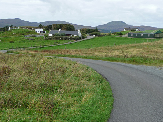
Harlosh

Harlosh (Scottish Gaelic: Heàrrlois) is a settlement on the island of Skye off the west coast of Scotland. The settlement is on a peninsula of the same...
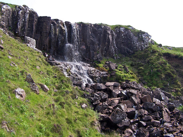
Eas Mòr, Durinish

Eas Mòr is a waterfall on the Duirinish peninsula of the island of Skye in Scotland. It lies on the Allt Mhicheil, a tributary of the Dibidal River below...

Nearby Amenities

Located within 500m of 57.363817,-6.5710464
Source: PGS
Lat/Long: 57.3599806/-6.5673252
Source: PGS
Lat/Long: 57.3601834/-6.5669788
Created By: dmgroom_coastlines
Source: PGS
Lat/Long: 57.36059/-6.56624
Created By: dmgroom_coastlines
Source: PGS
Lat/Long: 57.36072/-6.56599
Source: PGS
Lat/Long: 57.3605387/-6.5656152
Created By: dmgroom_coastlines
Source: PGS
Lat/Long: 57.36347/-6.56273
Beinn na Moine
Ele: 182
Natural: peak
Lat/Long: 57.3630094/-6.5699607
Rebel's Wood
Place: locality
Lat/Long: 57.3614067/-6.5756527
The data included in this document is from www.openstreetmap.org. The data is made available under ODbL.

Have you been to Beinn na Moine?

Leave your review of Beinn na Moine below (or comments, questions and feedback).