Hillborough Cliff

Cliff, Slope in Kent Canterbury

England

Hillborough Cliff

Hillborough buildings [1] The church of St Mary the Virgin in Reculver Lane was built in 1878. Constructed, as a Gothic Revival church in the Early English style, of knapped flint with limestone dressings under a tile roof. The south doorway is a 13th century one reused from the ancient church at Reculver as are a few stones at the junction of the nave and chancel. Listed, grade II, with details at: <span class="nowrap"><a title="https://historicengland.org.uk/listing/the-list/list-entry/1318906" rel="nofollow ugc noopener" href="https://historicengland.org.uk/listing/the-list/list-entry/1318906">Link</a><img style="margin-left:2px;" alt="External link" title="External link - shift click to open in new window" src="https://s1.geograph.org.uk/img/external.png" width="10" height="10"/></span>
Hillborough is a suburb of the town of Herne Bay, a seaside town on the Thames Estuary, some 6 miles north of Canterbury and about 4 miles east of Whitstable. It neighbours the ancient villages of Herne and Reculver.
Hillborough buildings [1] Credit: Michael Dibb

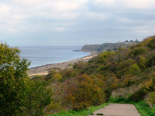
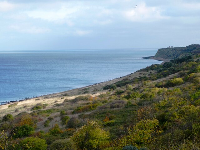
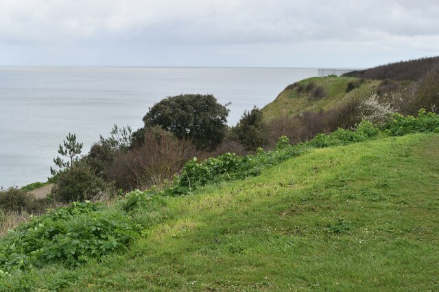
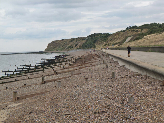
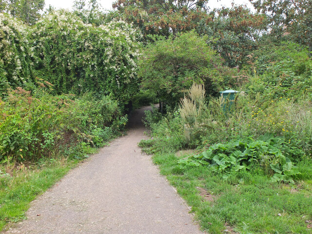
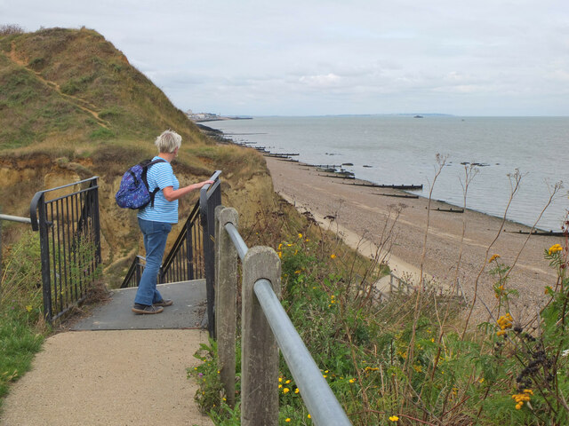
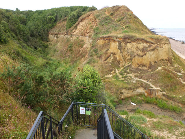
Hillborough Cliff is a prominent geological feature located in the county of Kent, England. Situated on the southeastern coast of the country, it forms part of the larger White Cliffs of Dover, a stretch of towering chalk cliffs that overlook the English Channel. Hillborough Cliff is specifically positioned near the village of St. Margaret's-at-Cliffe.

Rising to a height of approximately 100 meters (330 feet) above sea level, the cliff offers breathtaking panoramic views of the surrounding landscape and the vast expanse of the English Channel. It is renowned for its striking white appearance, attributed to the high chalk content in its composition. The chalk itself is formed from the remains of microscopic marine organisms that lived in the ancient oceans millions of years ago.

The cliff face of Hillborough Cliff is relatively steep, with a slope angle of around 70 degrees. This steepness, combined with the softness of the chalk, has led to a continuous process of erosion over time. Visitors to the site can witness the ongoing effects of this erosion, with occasional rockfalls and landslides shaping the cliff's contours. As a result, caution is advised when approaching the edge, and designated viewing areas are recommended for a safe experience.

Hillborough Cliff is not only a natural wonder but also holds historical significance. During World War II, it served as a strategic lookout point for the British armed forces, providing an advantageous vantage to spot and defend against potential enemy invasions.

Overall, Hillborough Cliff is a magnificent geological formation, offering both natural beauty and historical interest to those fortunate enough to visit.

If you have any feedback on the listing, please let us know in the comments section below.

Hillborough Cliff Images

Images are sourced within 2km of 51.374004/1.1648426 or Grid Reference TR2068. Thanks to Geograph Open Source API. All images are credited.

Hillborough buildings [1] The church of St Mary the Virgin in Reculver Lane was built in 1878. Constructed, as a Gothic Revival church in the Early English style, of knapped flint with limestone dressings under a tile roof. The south doorway is a 13th century one reused from the ancient church at Reculver as are a few stones at the junction of the nave and chancel. Listed, grade II, with details at: <span class="nowrap"><a title="https://historicengland.org.uk/listing/the-list/list-entry/1318906" rel="nofollow ugc noopener" href="https://historicengland.org.uk/listing/the-list/list-entry/1318906">Link</a><img style="margin-left:2px;" alt="External link" title="External link - shift click to open in new window" src="https://s1.geograph.org.uk/img/external.png" width="10" height="10"/></span>
Hillborough is a suburb of the town of Herne Bay, a seaside town on the Thames Estuary, some 6 miles north of Canterbury and about 4 miles east of Whitstable. It neighbours the ancient villages of Herne and Reculver.
Hillborough buildings [1]
The church of St Mary the Virgin in Reculver Lane was built in 1878. Constructed, as a Gothic Revival church in the Early English style, of knapped flint with limestone dressings under a tile roof. The south doorway is a 13th century one reused from the ancient church at Reculver as are a few stones at the junction of the nave and chancel. Listed, grade II, with details at: LinkExternal link Hillborough is a suburb of the town of Herne Bay, a seaside town on the Thames Estuary, some 6 miles north of Canterbury and about 4 miles east of Whitstable. It neighbours the ancient villages of Herne and Reculver.
War memorial The Reculver war memorial is in the churchyard of the church of St Mary. Erected in 1919, it is a stone remembrance of rough-hewn granite. Listed, grade II, with details at: <span class="nowrap"><a title="https://historicengland.org.uk/listing/the-list/list-entry/1393473" rel="nofollow ugc noopener" href="https://historicengland.org.uk/listing/the-list/list-entry/1393473">Link</a><img style="margin-left:2px;" alt="External link" title="External link - shift click to open in new window" src="https://s1.geograph.org.uk/img/external.png" width="10" height="10"/></span>
Hillborough is a suburb of the town of Herne Bay, a seaside town on the Thames Estuary, some 6 miles north of Canterbury and about 4 miles east of Whitstable. It neighbours the ancient villages of Herne and Reculver.
War memorial
The Reculver war memorial is in the churchyard of the church of St Mary. Erected in 1919, it is a stone remembrance of rough-hewn granite. Listed, grade II, with details at: LinkExternal link Hillborough is a suburb of the town of Herne Bay, a seaside town on the Thames Estuary, some 6 miles north of Canterbury and about 4 miles east of Whitstable. It neighbours the ancient villages of Herne and Reculver.
Hillborough buildings [2] Part of the churchyard.
The church of St Mary the Virgin in Reculver Lane was built in 1878. Constructed, as a Gothic Revival church in the Early English style, of knapped flint with limestone dressings under a tile roof. The south doorway is a 13th century one reused from the ancient church at Reculver as are a few stones at the junction of the nave and chancel. Listed, grade II, with details at: <span class="nowrap"><a title="https://historicengland.org.uk/listing/the-list/list-entry/1318906" rel="nofollow ugc noopener" href="https://historicengland.org.uk/listing/the-list/list-entry/1318906">Link</a><img style="margin-left:2px;" alt="External link" title="External link - shift click to open in new window" src="https://s1.geograph.org.uk/img/external.png" width="10" height="10"/></span>
Hillborough is a suburb of the town of Herne Bay, a seaside town on the Thames Estuary, some 6 miles north of Canterbury and about 4 miles east of Whitstable. It neighbours the ancient villages of Herne and Reculver.
Hillborough buildings [2]
Part of the churchyard. The church of St Mary the Virgin in Reculver Lane was built in 1878. Constructed, as a Gothic Revival church in the Early English style, of knapped flint with limestone dressings under a tile roof. The south doorway is a 13th century one reused from the ancient church at Reculver as are a few stones at the junction of the nave and chancel. Listed, grade II, with details at: LinkExternal link Hillborough is a suburb of the town of Herne Bay, a seaside town on the Thames Estuary, some 6 miles north of Canterbury and about 4 miles east of Whitstable. It neighbours the ancient villages of Herne and Reculver.
Hillborough buildings [3] The Reculver Church of England Primary School in Reculver Lane.
Hillborough is a suburb of the town of Herne Bay, a seaside town on the Thames Estuary, some 6 miles north of Canterbury and about 4 miles east of Whitstable. It neighbours the ancient villages of Herne and Reculver.
Hillborough buildings [3]
The Reculver Church of England Primary School in Reculver Lane. Hillborough is a suburb of the town of Herne Bay, a seaside town on the Thames Estuary, some 6 miles north of Canterbury and about 4 miles east of Whitstable. It neighbours the ancient villages of Herne and Reculver.
Hillborough buildings [4] St Mary's Cottage is, probably, 17th century. Now partly stuccoed and partly pebbledashed, all under a thatch roof. Listed, grade II, with details at: <span class="nowrap"><a title="https://historicengland.org.uk/listing/the-list/list-entry/1336864" rel="nofollow ugc noopener" href="https://historicengland.org.uk/listing/the-list/list-entry/1336864">Link</a><img style="margin-left:2px;" alt="External link" title="External link - shift click to open in new window" src="https://s1.geograph.org.uk/img/external.png" width="10" height="10"/></span>
Hillborough is a suburb of the town of Herne Bay, a seaside town on the Thames Estuary, some 6 miles north of Canterbury and about 4 miles east of Whitstable. It neighbours the ancient villages of Herne and Reculver.
Hillborough buildings [4]
St Mary's Cottage is, probably, 17th century. Now partly stuccoed and partly pebbledashed, all under a thatch roof. Listed, grade II, with details at: LinkExternal link Hillborough is a suburb of the town of Herne Bay, a seaside town on the Thames Estuary, some 6 miles north of Canterbury and about 4 miles east of Whitstable. It neighbours the ancient villages of Herne and Reculver.
Hillborough buildings [5] Forge House, Reculver Lane, is an 18th century building. Constructed of rendered brick under a tile roof. There is a modern extension on the right. Listed, grade II, with details at: <span class="nowrap"><a title="https://historicengland.org.uk/listing/the-list/list-entry/1084988" rel="nofollow ugc noopener" href="https://historicengland.org.uk/listing/the-list/list-entry/1084988">Link</a><img style="margin-left:2px;" alt="External link" title="External link - shift click to open in new window" src="https://s1.geograph.org.uk/img/external.png" width="10" height="10"/></span>
Hillborough is a suburb of the town of Herne Bay, a seaside town on the Thames Estuary, some 6 miles north of Canterbury and about 4 miles east of Whitstable. It neighbours the ancient villages of Herne and Reculver.
Hillborough buildings [5]
Forge House, Reculver Lane, is an 18th century building. Constructed of rendered brick under a tile roof. There is a modern extension on the right. Listed, grade II, with details at: LinkExternal link Hillborough is a suburb of the town of Herne Bay, a seaside town on the Thames Estuary, some 6 miles north of Canterbury and about 4 miles east of Whitstable. It neighbours the ancient villages of Herne and Reculver.
227, Reculver Road In May 2019, the location was a <a href="https://www.geograph.org.uk/photo/6178362">TR2068 : Building site, 227, Reculver Road</a>.
227, Reculver Road
In May 2019, the location was a TR2068 : Building site, 227, Reculver Road.
208, Reculver Road Planning permission has been approved by Canterbury City Council under application number CA/21/02321 for a “detached dwelling with associated external works following demolition of existing bungalow”. 

The view shows the bungalow during demolition.
208, Reculver Road
Planning permission has been approved by Canterbury City Council under application number CA/21/02321 for a “detached dwelling with associated external works following demolition of existing bungalow”. The view shows the bungalow during demolition.
Coast north of Bishopsboiurne Herne Bay Viewed from Ocean View and looking towards Reculver.
Coast north of Bishopsboiurne Herne Bay
Viewed from Ocean View and looking towards Reculver.
Coast north of Bishopsboiurne Herne Bay Looking eastwards towards Reculver.
Coast north of Bishopsboiurne Herne Bay
Looking eastwards towards Reculver.
Coast below Ocean View Car Park
Shingle beach, Herne Bay Wooden groynes to keep in check mass transport of the shingle by wave action.
Shingle beach, Herne Bay
Wooden groynes to keep in check mass transport of the shingle by wave action.
Junction for the path to Reculver The Oyster Bay Trail heads up the slope to cross the Bishopstone Glen, also known as the Oldhaven Gap, a gap between two sand cliffs. Drainage work has helped to stabilise the slope of London Clay (information from the nearby board).
Junction for the path to Reculver
The Oyster Bay Trail heads up the slope to cross the Bishopstone Glen, also known as the Oldhaven Gap, a gap between two sand cliffs. Drainage work has helped to stabilise the slope of London Clay (information from the nearby board).
Path in Bishopstone Glen, Herne Bay The coastal path swings inland around the short valley of Bishopstone Glen, formed by a gap between two sand cliffs.
Path in Bishopstone Glen, Herne Bay
The coastal path swings inland around the short valley of Bishopstone Glen, formed by a gap between two sand cliffs.
Path above Bishopstone Glen, Herne Bay The railings fence off the steep bank of the stream below.
Path above Bishopstone Glen, Herne Bay
The railings fence off the steep bank of the stream below.
Wooden sculpture, Bishopstone Glen Formerly the path here crossed through 'Fairy Woods' where local resident James Robinson had turned the bottom of his garden into an attraction with fairy houses, gnomes and crazy paving (from the information board on the coastal path).
Wooden sculpture, Bishopstone Glen
Formerly the path here crossed through 'Fairy Woods' where local resident James Robinson had turned the bottom of his garden into an attraction with fairy houses, gnomes and crazy paving (from the information board on the coastal path).
Top of the 100 steps, Bishopstone Glen, Herne Bay Steps up from the eastern side of the glen, a gap formed between two sand cliffs.
Top of the 100 steps, Bishopstone Glen, Herne Bay
Steps up from the eastern side of the glen, a gap formed between two sand cliffs.
Bishopstone Glen, Herne Bay A short steep-sided valley between two sand cliffs. The cliffs are sandstone with London Clay on top, in which fossils up to 60 million years old have been found (from the information board by the coastal path).
Bishopstone Glen, Herne Bay
A short steep-sided valley between two sand cliffs. The cliffs are sandstone with London Clay on top, in which fossils up to 60 million years old have been found (from the information board by the coastal path).
Show me another place!

Hillborough Cliff is located at Grid Ref: TR2068 (Lat: 51.374004, Lng: 1.1648426)

Administrative County: Kent

District: Canterbury

Police Authority: Kent

What 3 Words

///insert.awake.mental. Near Herne Bay, Kent

Related Wikis

Beltinge

Beltinge is a low cliff-top suburb of Herne Bay in Kent, England. It forms the easternmost part of the urban area of Herne Bay and is just west of the...

Bishopstone Cliffs

Bishopstone Cliffs is a 67.4-hectare (167-acre) Local Nature Reserve in Reculver on the eastern outskirts of Herne Bay, Kent. It is owned and managed...

Hillborough

Hillborough is an area of eastern Herne Bay in Kent, England. The population is included in the Reculver ward of Herne Bay. == External links == Media...

Church of St Mary the Virgin, Reculver

The Church of St Mary the Virgin, Reculver, is an Anglican church on Reculver Lane in the village of Hillborough, in the parish of Reculver, in north-eastern...

Related Videos

Beltinge & Reculver Towers, a Walking History Tour Guide Using Postcards Kent UK

Beltinge & Reculver Towers, Kent, UK, A walking history tour guide of Beltinge & Reculver Towers using old postcards.

Walking For MacMillan.

Walking, hiking, wild swimming, kayaking, outdoor pursuits and JUST LIVING in Kent.

Chausson 711 Travel Line

This 2020 Chausson 711 Travel Line is a great choice for couples or small families who want a modern, practical, and luxurious ...

Nearby Amenities

Located within 500m of 51.374004,1.1648426
Parking
Lat/Long: 51.3725773/1.1611343
Turning Circle
Lat/Long: 51.3724459/1.1693291
Turning Circle
Wantsum Close
Lit: yes
Maxspeed: 30 mph
Surface: block_paving
Turning Circle: hammer
Lat/Long: 51.372555/1.1681905
Post Box
Brand: Royal Mail
Brand Wikidata: Q638098
Brand Wikipedia: en:Royal Mail
Collection Times: Mo-Fr 09:00; Sa 07:00
Operator: Royal Mail
Operator Wikidata: Q638098
Post Box Mounting: metal_post
Post Box Type: lamp
Postal Code: CT6
Ref: CT6 286
Royal Cypher: EIIR
Royal Cypher Wikidata: Q33102113
Source: survey
Lat/Long: 51.3719115/1.1711008
Telephone
Booth: K6
Covered: booth
Payment Coins: yes
Payment Credit Cards: yes
Payment Debit Cards: yes
Phone: +44 1227 373268
Lat/Long: 51.3732962/1.1695788
Noexit: yes
Lat/Long: 51.3712158/1.1674251
Turning Circle
Lat/Long: 51.372003/1.1659184
Post Box
Brand: Royal Mail
Brand Wikidata: Q638098
Brand Wikipedia: en:Royal Mail
Collection Times: Mo-Fr 09:00; Sa 07:00
Operator: Royal Mail
Operator Wikidata: Q638098
Post Box Mounting: brick_pillar
Post Box Type: wall
Ref: CT6 174
Royal Cypher: GR
Royal Cypher Wikidata: Q33102273
Lat/Long: 51.370549/1.1616166
Bus Stop
Gainsborough Drive
Naptan AtcoCode: 2400A041440A
Naptan Bearing: SE
Naptan CommonName: Gainsborough Drive
Naptan Indicator: adj
Naptan Landmark: Gainsborough Drive
Naptan NaptanCode: kntdtdjw
Naptan PlusbusZoneRef: HRNEBAY
Naptan Street: Reculver Road
Naptan Verified: no
Public Transport: platform
Ref: kntdtdjw
Source: naptan_import
Source Date: 2008-06-02T16:03:00
Lat/Long: 51.3707181/1.1616699
Bus Stop
Bishopstone Lane
Naptan AtcoCode: 2400A041450A
Naptan Bearing: E
Naptan CommonName: Bishopstone Lane
Naptan Indicator: adj
Naptan Landmark: Bishopstone Lane
Naptan NaptanCode: kntdtdma
Naptan PlusbusZoneRef: HRNEBAY
Naptan Street: Reculver Road
Naptan Verified: no
Public Transport: platform
Ref: kntdtdma
Source: naptan_import
Source Date: 2013-11-25T14:43:00
Lat/Long: 51.3699882/1.1680431
Bus Stop
Bishopstone Lane
Naptan AtcoCode: 2400A041480A
Naptan Bearing: W
Naptan CommonName: Bishopstone Lane
Naptan Indicator: opp
Naptan Landmark: Bishopstone Lane
Naptan NaptanCode: kntdtdmj
Naptan PlusbusZoneRef: HRNEBAY
Naptan Street: Reculver Road
Naptan Verified: no
Public Transport: platform
Ref: kntdtdmj
Source: naptan_import
Source Date: 2018-08-20T12:56:00
Lat/Long: 51.3700138/1.1670964
Bus Stop
Gainsborough Drive
Naptan AtcoCode: 2400A041490A
Naptan Bearing: NW
Naptan CommonName: Gainsborough Drive
Naptan Indicator: opp
Naptan Landmark: Gainsborough Drive
Naptan NaptanCode: kntdtdmp
Naptan PlusbusZoneRef: HRNEBAY
Naptan Street: Reculver Road
Naptan Verified: no
Public Transport: platform
Ref: kntdtdmp
Source: naptan_import
Source Date: 2018-08-20T12:53:00
Lat/Long: 51.3704839/1.1616825
Turning Circle
Lat/Long: 51.3711142/1.166412
Bicycle Parking
Bicycle Parking: stands
Capacity: 8
Covered: no
Cyclestreets Id: 26770
Note: Wooden sheffield stands
Lat/Long: 51.3737983/1.1672573
Bishopstone
Place: suburb
Source: OS_OpenData_StreetView
Lat/Long: 51.3734918/1.1714337
Barrier: kissing_gate
Bicycle: yes
Foot: yes
Lat/Long: 51.372123/1.1661629
Traffic Calming: island
Lat/Long: 51.3703083/1.1664212
Bench
Lat/Long: 51.3744487/1.170031
Bench
Reculver Towers Bench
Backrest: no
Material: wood
Lat/Long: 51.3738185/1.1668042
Information: board
Tourism: information
Lat/Long: 51.3737262/1.1672386
Bench
Lat/Long: 51.374216/1.1681542
Entrance: main
Lat/Long: 51.3736713/1.1666378
Generator Method: photovoltaic
Generator Output Electricity: yes
Generator Solar Modules: 6
Generator Source: solar
Generator Type: solar_photovoltaic_panel
Power: generator
Lat/Long: 51.3734584/1.1697133
Generator Method: photovoltaic
Generator Output Electricity: yes
Generator Source: solar
Generator Type: solar_photovoltaic_panel
Location: roof
Power: generator
Lat/Long: 51.3720315/1.1662325
Generator Method: photovoltaic
Generator Orientation: 157
Generator Output Electricity: yes
Generator Source: solar
Generator Type: solar_photovoltaic_panel
Location: roof
Power: generator
Lat/Long: 51.3722927/1.1614072
Generator Method: photovoltaic
Generator Orientation: 155
Generator Output Electricity: yes
Generator Source: solar
Generator Type: solar_photovoltaic_panel
Location: roof
Power: generator
Lat/Long: 51.3724602/1.1620697
Generator Method: photovoltaic
Generator Output Electricity: yes
Generator Source: solar
Generator Type: solar_photovoltaic_panel
Location: roof
Power: generator
Lat/Long: 51.3716062/1.1654171
Generator Method: photovoltaic
Generator Output Electricity: yes
Generator Source: solar
Generator Type: solar_photovoltaic_panel
Location: roof
Power: generator
Lat/Long: 51.3714371/1.1685607
Generator Method: photovoltaic
Generator Orientation: 244
Generator Output Electricity: yes
Generator Source: solar
Generator Type: solar_photovoltaic_panel
Location: roof
Power: generator
Lat/Long: 51.3713224/1.161017
Bishopstone Glen
Tourism: viewpoint
Lat/Long: 51.3745041/1.1693385
Man Made: beacon
Lat/Long: 51.3726885/1.1611593
Leisure: picnic_table
Material: wood
Lat/Long: 51.3727674/1.1613334
Leisure: picnic_table
Material: wood
Lat/Long: 51.3727443/1.1612902
Board Type: nature
Information: board
Tourism: information
Lat/Long: 51.3727827/1.1611624
Bench: yes
Leisure: picnic_table
Lit: no
Material: wood
Lat/Long: 51.3726886/1.1671371
Bench: yes
Leisure: picnic_table
Lit: no
Material: wood
Lat/Long: 51.3726425/1.167121
Generator Method: photovoltaic
Generator Output Electricity: yes
Generator Solar Modules: 2
Generator Source: solar
Generator Type: solar_photovoltaic_panel
Location: roof
Power: generator
Lat/Long: 51.3709457/1.162637
Generator Method: photovoltaic
Generator Output Electricity: yes
Generator Solar Modules: 2
Generator Source: solar
Generator Type: solar_photovoltaic_panel
Location: roof
Power: generator
Lat/Long: 51.3709532/1.1626625
Generator Method: photovoltaic
Generator Output Electricity: yes
Generator Solar Modules: 2
Generator Source: solar
Generator Type: solar_photovoltaic_panel
Location: roof
Power: generator
Lat/Long: 51.3709817/1.1626746
Generator Method: photovoltaic
Generator Output Electricity: yes
Generator Solar Modules: 2
Generator Source: solar
Generator Type: solar_photovoltaic_panel
Location: roof
Power: generator
Lat/Long: 51.3709591/1.1625941
Generator Method: photovoltaic
Generator Output Electricity: yes
Generator Source: solar
Generator Type: solar_photovoltaic_panel
Location: roof
Power: generator
Lat/Long: 51.3735033/1.1647654
Generator Method: photovoltaic
Generator Output Electricity: yes
Generator Source: solar
Generator Type: solar_photovoltaic_panel
Location: roof
Power: generator
Lat/Long: 51.3734263/1.1646956
Generator Method: photovoltaic
Generator Output Electricity: yes
Generator Source: solar
Generator Type: solar_photovoltaic_panel
Location: roof
Power: generator
Lat/Long: 51.372281/1.1614877
Generator Method: photovoltaic
Generator Output Electricity: yes
Generator Source: solar
Generator Type: solar_photovoltaic_panel
Location: roof
Power: generator
Lat/Long: 51.3719286/1.1599226
Generator Method: photovoltaic
Generator Output Electricity: yes
Generator Source: solar
Generator Type: solar_photovoltaic_panel
Location: roof
Power: generator
Lat/Long: 51.3718892/1.158603
Generator Method: photovoltaic
Generator Output Electricity: yes
Generator Source: solar
Generator Type: solar_photovoltaic_panel
Location: roof
Power: generator
Lat/Long: 51.3721722/1.1585212
Generator Method: photovoltaic
Generator Output Electricity: yes
Generator Source: solar
Generator Type: solar_photovoltaic_panel
Location: roof
Power: generator
Lat/Long: 51.3722032/1.1586379
Generator Method: photovoltaic
Generator Output Electricity: yes
Generator Source: solar
Generator Type: solar_photovoltaic_panel
Location: roof
Power: generator
Lat/Long: 51.3709733/1.159527
Generator Method: photovoltaic
Generator Output Electricity: yes
Generator Source: solar
Generator Type: solar_photovoltaic_panel
Location: roof
Power: generator
Lat/Long: 51.3710068/1.1595431
Generator Method: photovoltaic
Generator Output Electricity: yes
Generator Source: solar
Generator Type: solar_photovoltaic_panel
Location: roof
Power: generator
Lat/Long: 51.3706284/1.1604081
Generator Method: photovoltaic
Generator Output Electricity: yes
Generator Source: solar
Generator Type: solar_photovoltaic_panel
Location: roof
Power: generator
Lat/Long: 51.3706309/1.1604846
Generator Method: photovoltaic
Generator Output Electricity: yes
Generator Solar Modules: 9
Generator Source: solar
Generator Type: solar_photovoltaic_panel
Location: roof
Power: generator
Lat/Long: 51.3716715/1.1697704
Generator Method: photovoltaic
Generator Output Electricity: yes
Generator Solar Modules: 4
Generator Source: solar
Generator Type: solar_photovoltaic_panel
Location: roof
Power: generator
Lat/Long: 51.3716468/1.1698327
Generator Method: photovoltaic
Generator Output Electricity: yes
Generator Solar Modules: 10
Generator Source: solar
Generator Type: solar_photovoltaic_panel
Location: roof
Power: generator
Lat/Long: 51.3720667/1.1704731
Generator Method: photovoltaic
Generator Output Electricity: yes
Generator Solar Modules: 6
Generator Source: solar
Generator Type: solar_photovoltaic_panel
Location: roof
Power: generator
Lat/Long: 51.3720776/1.1705838
Generator Method: photovoltaic
Generator Output Electricity: yes
Generator Solar Modules: 6
Generator Source: solar
Generator Type: solar_photovoltaic_panel
Location: roof
Power: generator
Lat/Long: 51.3718633/1.1707011
Noexit: yes
Lat/Long: 51.3721318/1.1664504
Traffic Calming: island
Lat/Long: 51.3701839/1.1663773
Noexit: yes
Lat/Long: 51.3717498/1.1669125
Generator Method: photovoltaic
Generator Output Electricity: yes
Generator Source: solar
Generator Type: solar_photovoltaic_panel
Location: roof
Power: generator
Lat/Long: 51.3724598/1.1703678
Generator Method: photovoltaic
Generator Output Electricity: yes
Generator Source: solar
Generator Type: solar_photovoltaic_panel
Location: roof
Power: generator
Lat/Long: 51.3724254/1.1703041
The data included in this document is from www.openstreetmap.org. The data is made available under ODbL.

Have you been to Hillborough Cliff?

Leave your review of Hillborough Cliff below (or comments, questions and feedback).