Bidein Boidheach

Cliff, Slope in Inverness-shire

Scotland

Bidein Boidheach

Loch Caol na Cora-bheinne Some of the Skye mountains framed by the hillsides at the western arm of this U-shaped lochan below Cora-bheinn.
Loch Caol na Cora-bheinne Credit: Jim Barton

Bidein Boidheach, located in Inverness-shire, Scotland, is an awe-inspiring cliff and slope formation that attracts visitors from around the world. This natural wonder is situated in the northwestern part of the country, near the village of Torridon, and is a prominent feature of the Torridon Hills.

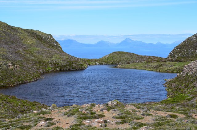
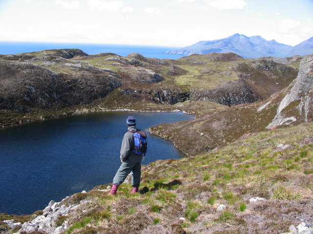
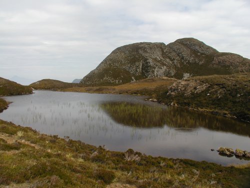
Bidein Boidheach, which translates to "Beautiful Peak" in Gaelic, is known for its stunning geological features. It is part of the Torridonian sandstone formation, which dates back billions of years. The cliff stands at an impressive height of approximately 3,232 feet (985 meters) and offers breathtaking panoramic views of the surrounding landscape.

The slope of Bidein Boidheach is characterized by its steepness and ruggedness. The rock face is weathered and craggy, displaying the effects of erosion over time. The slope is covered in a variety of vegetation, including heather, mosses, and grasses, adding to its scenic beauty.

Hiking enthusiasts and nature lovers are drawn to Bidein Boidheach for its challenging yet rewarding trails. The ascent to the summit is known to be demanding, requiring a good level of fitness and experience in mountain climbing. However, those who reach the top are rewarded with unforgettable views of the Scottish Highlands, including the nearby Loch Torridon and the surrounding peaks.

Due to its remote location, access to Bidein Boidheach can be limited, and it is advisable to consult local guides or experienced climbers before attempting the climb. Nonetheless, this majestic cliff and slope provide an unforgettable experience for those seeking adventure and natural beauty in the heart of Inverness-shire.

If you have any feedback on the listing, please let us know in the comments section below.

Bidein Boidheach Images

Images are sourced within 2km of 56.899216/-6.2057089 or Grid Reference NM4486. Thanks to Geograph Open Source API. All images are credited.

Loch Caol na Cora-bheinne Some of the Skye mountains framed by the hillsides at the western arm of this U-shaped lochan below Cora-bheinn.
Loch Caol na Cora-bheinne
Some of the Skye mountains framed by the hillsides at the western arm of this U-shaped lochan below Cora-bheinn.
Cora-bheinn One of the summits on the moorland NW of An Sgurr; this has a 350m spot height.
Cora-bheinn
One of the summits on the moorland NW of An Sgurr; this has a 350m spot height.
Eastern arm of Loch Caol na Cora-bheinne The eastern arm of this U-shaped lochan with An Sgurr in the background.
Eastern arm of Loch Caol na Cora-bheinne
The eastern arm of this U-shaped lochan with An Sgurr in the background.
Boulder field by Loch Caol na Cora-bheinne The traverse of the loch shore includes this short stretch of boulders below the rock face.
Boulder field by Loch Caol na Cora-bheinne
The traverse of the loch shore includes this short stretch of boulders below the rock face.
Loch nam Bàn Mòra from the ridge of An Sgùrr, Eigg The Isle of Rum dominates the horizon.
Loch nam Bàn Mòra from the ridge of An Sgùrr, Eigg
The Isle of Rum dominates the horizon.
Grulin Iochdrach Ruins of the township at Grulin Iochdrach. 14 families were cleared from Grulin in 1853 to make way for sheep. Most emigrated to Nova Scotia.
Grulin Iochdrach
Ruins of the township at Grulin Iochdrach. 14 families were cleared from Grulin in 1853 to make way for sheep. Most emigrated to Nova Scotia.
Lochan Nighean beneath An Sgurr
Beinn Tighe In the wild and lovely hills of south Eigg, this is Loch Beinn Tighe with Beinn Tighe (probably meaning "Mountain with a house upon it") behind.
Beinn Tighe
In the wild and lovely hills of south Eigg, this is Loch Beinn Tighe with Beinn Tighe (probably meaning "Mountain with a house upon it") behind.
Pebbly bay on the south west corner of Eigg Remote spot - plenty of driftwood and debris
Pebbly bay on the south west corner of Eigg
Remote spot - plenty of driftwood and debris
High cliffs on the west coast of Eigg
South coast of Eigg The old track leads to a deserted crofting settlement with lazy beds still visible even in fairly inaccessible places.
South coast of Eigg
The old track leads to a deserted crofting settlement with lazy beds still visible even in fairly inaccessible places.
Columnar jointing on southern Eigg Columnar jointing in pitchstone lavas between the Sgurr of Eigg and Beinn Tighe, looking very like man-made drystone walls
Columnar jointing on southern Eigg
Columnar jointing in pitchstone lavas between the Sgurr of Eigg and Beinn Tighe, looking very like man-made drystone walls
Close up of columnar jointing Columnar jointing in lavas on Isle of Eigg. Similar to features found nearby on the Sgurr of Eigg and probably the same rock type.
Close up of columnar jointing
Columnar jointing in lavas on Isle of Eigg. Similar to features found nearby on the Sgurr of Eigg and probably the same rock type.
Sgeir Sgaothaig, Isle of Eigg This skerry if often awash. Formed from basalt.
Sgeir Sgaothaig, Isle of Eigg
This skerry if often awash. Formed from basalt.
Crumbling basalt sea cliff below Beinn Tighe The cliff sports a large cave surrounded by a loose basalt cliff face. There are also many caves at sea level.
Crumbling basalt sea cliff below Beinn Tighe
The cliff sports a large cave surrounded by a loose basalt cliff face. There are also many caves at sea level.
Sea cliffs below Beinn Tighe The basalt cliffs below Beinn Tighe are very loose. Many caves can be found at sealevel due to wave action.
Sea cliffs below Beinn Tighe
The basalt cliffs below Beinn Tighe are very loose. Many caves can be found at sealevel due to wave action.
Basalt sea cliff below Sliabh Beinn Tighe This buttress of a sea cliff is riven with caves as a result of wave action.
Basalt sea cliff below Sliabh Beinn Tighe
This buttress of a sea cliff is riven with caves as a result of wave action.
Rum sunset from Eigg cliff top Flat calm ocean with no sea breeze = midge heaven.
Rum sunset from Eigg cliff top
Flat calm ocean with no sea breeze = midge heaven.
Show me another place!

Bidein Boidheach is located at Grid Ref: NM4486 (Lat: 56.899216, Lng: -6.2057089)

Unitary Authority: Highland

Police Authority: Highlands and Islands

What 3 Words

///treaty.third.lavished. Near Arisaig, Highland

Related Wikis

Eigg

Eigg ( eg; Scottish Gaelic: Eige; Scots: Eigg) is one of the Small Isles in the Scottish Inner Hebrides. It lies to the south of the Isle of Skye and to...

An Sgùrr (Eigg)

An Sgùrr is the highest hill on the Inner Hebridean island of Eigg, Lochaber, Highland, Scotland. It was formed 58.72 ± 0.07 million years ago; the result...

Cleadale

Cleadale (Scottish Gaelic: Clèadail) is a settlement on the north west side of the island of Eigg, in the Small Isles of Scotland and is in the council...

Galmisdale

Galmisdale is the main port of the island of Eigg, one of the Small Isles of the Inner Hebrides. It is in the Scottish council area of Highland. ��2�...

Nearby Amenities

Located within 500m of 56.899216,-6.2057089
Source: PGS
Lat/Long: 56.8948827/-6.206758
Source: PGS
Lat/Long: 56.8950986/-6.2066967
Source: PGS
Lat/Long: 56.8954306/-6.2066613
Source: PGS
Lat/Long: 56.895941/-6.2066895
Source: PGS
Lat/Long: 56.8960853/-6.206757
Source: PGS
Lat/Long: 56.8963489/-6.2069213
Source: PGS
Lat/Long: 56.8965406/-6.2069982
Source: PGS
Lat/Long: 56.8967104/-6.2070203
Source: PGS
Lat/Long: 56.8969478/-6.2069736
Source: PGS
Lat/Long: 56.897063/-6.2071187
Source: PGS
Lat/Long: 56.8970188/-6.2070445
Source: PGS
Lat/Long: 56.8970904/-6.2071985
Source: PGS
Lat/Long: 56.8971438/-6.2074157
Source: PGS
Lat/Long: 56.8971874/-6.2075202
Source: PGS
Lat/Long: 56.8972479/-6.2075923
Source: PGS
Lat/Long: 56.8973232/-6.2076237
Source: PGS
Lat/Long: 56.8973786/-6.2076178
Source: PGS
Lat/Long: 56.8974176/-6.2075882
Source: PGS
Lat/Long: 56.8974741/-6.2073398
Source: PGS
Lat/Long: 56.8974516/-6.207407
Source: PGS
Lat/Long: 56.897604/-6.2072355
Source: PGS
Lat/Long: 56.8975241/-6.2072799
Source: PGS
Lat/Long: 56.8974364/-6.207544
Source: PGS
Lat/Long: 56.8981158/-6.2071076
Source: PGS
Lat/Long: 56.8991253/-6.2069509
Source: PGS
Lat/Long: 56.8989792/-6.206958
Source: PGS
Lat/Long: 56.8985735/-6.2070444
Source: PGS
Lat/Long: 56.8992268/-6.2069858
Source: PGS
Lat/Long: 56.8992926/-6.2070602
Source: PGS
Lat/Long: 56.8997185/-6.2069173
Source: PGS
Lat/Long: 56.8999127/-6.2062343
Source: PGS
Lat/Long: 56.9012727/-6.2061001
Source: PGS
Lat/Long: 56.902148/-6.2073326
Source: PGS
Lat/Long: 56.9021883/-6.2075889
Source: PGS
Lat/Long: 56.9025478/-6.2080449
Source: PGS
Lat/Long: 56.9023265/-6.2078494
Source: PGS
Lat/Long: 56.902658/-6.2081767
Source: PGS
Lat/Long: 56.9027373/-6.2083181
Source: PGS
Lat/Long: 56.9029094/-6.208702
Source: PGS
Lat/Long: 56.9029974/-6.2087918
Source: PGS
Lat/Long: 56.9032188/-6.2089024
Source: PGS
Lat/Long: 56.9033286/-6.2089095
Source: PGS
Lat/Long: 56.9031105/-6.2088647
The data included in this document is from www.openstreetmap.org. The data is made available under ODbL.

Have you been to Bidein Boidheach?

Leave your review of Bidein Boidheach below (or comments, questions and feedback).