Boswednack Cliff

Cliff, Slope in Cornwall

England

Boswednack Cliff

Coastal views near Zennor in the fading light
Coastal views near Zennor in the fading light Credit: thejackrustles

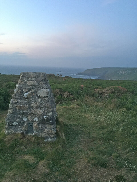
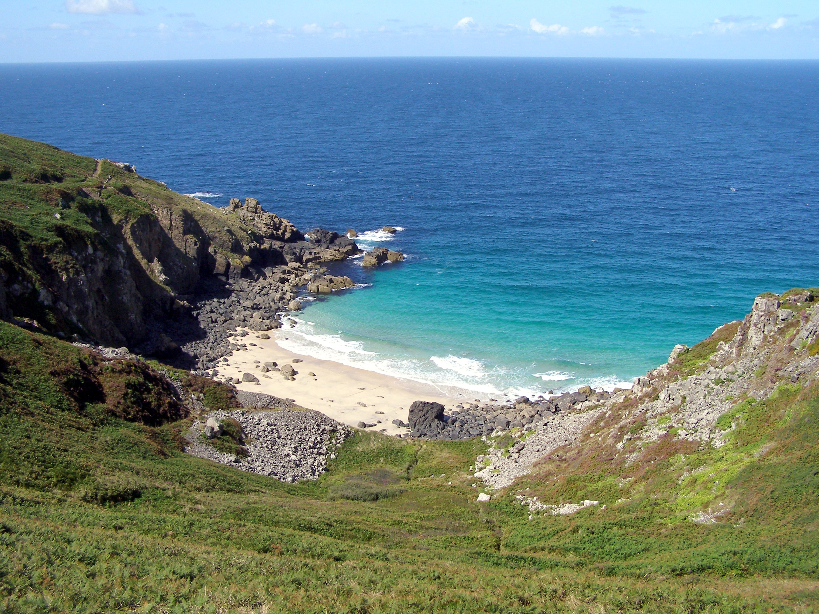
Boswednack Cliff is a prominent cliff located in Cornwall, England. Situated on the rugged coastline of the Land's End Peninsula, this cliff offers breathtaking views of the Atlantic Ocean. It is part of an area known for its dramatic landscape and scenic beauty.

Standing at an impressive height of approximately 50 meters, Boswednack Cliff boasts steep slopes and jagged rock formations. Its geological composition consists mainly of granite, which has been shaped by centuries of erosion and weathering. This has resulted in the creation of numerous caves and crevices along the cliff face.

The cliff is surrounded by lush vegetation, including grasses, shrubs, and wildflowers. During spring and summer, the area becomes a haven for nesting seabirds, such as gulls and fulmars. Visitors can often spot these birds perched on the cliff ledges or soaring above the crashing waves.

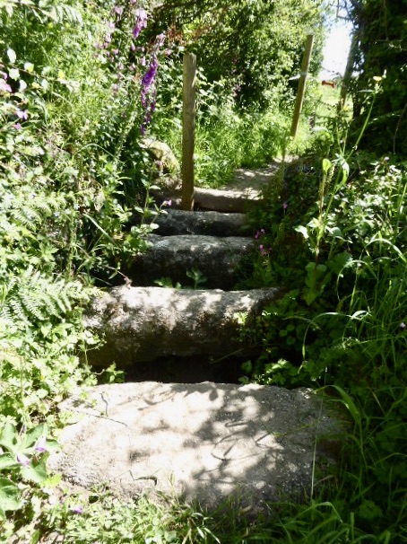
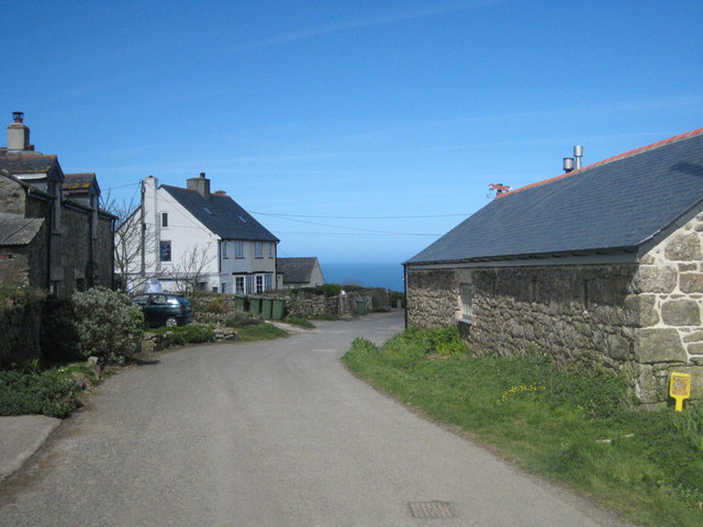
Access to Boswednack Cliff is possible through a network of footpaths and trails that wind their way along the coastline. These paths offer a chance to explore the surrounding area and discover hidden coves, sandy beaches, and other geological wonders.

The cliff provides an ideal vantage point for watching the powerful swells of the Atlantic Ocean and witnessing dramatic sunsets. It is a popular spot for photographers, hikers, and nature enthusiasts who seek a peaceful retreat in the midst of Cornwall's natural beauty.

Visitors are advised to exercise caution when near the cliff edge due to its steepness and unpredictable weather conditions. Protective barriers and warning signs are in place to ensure the safety of visitors.

If you have any feedback on the listing, please let us know in the comments section below.

Boswednack Cliff Images

Images are sourced within 2km of 50.191131/-5.5881141 or Grid Reference SW4338. Thanks to Geograph Open Source API. All images are credited.

Coastal views near Zennor in the fading light
Footpath to Zennor Head
Zennor Cliff Trig Point Flush Bracket S8143
Porthmeor Cove from the South West Coast Path
Stone Stile SW4237a Boundary from field into Bosigran farm buildings, on Bosigran farm land north of B3306, west of Porthmeor stream. Public footpath 120/15/1 and 120/14/3 Gold. Circa early C19. Dressed granite moorstone and granite rubble. Stepped cattle stile adjoining rubble-faced hedge. Parish: Zennor
HER Number: DCO11754  Grade II listed No. 1144347
Stone Stile SW4237a
Boundary from field into Bosigran farm buildings, on Bosigran farm land north of B3306, west of Porthmeor stream. Public footpath 120/15/1 and 120/14/3 Gold. Circa early C19. Dressed granite moorstone and granite rubble. Stepped cattle stile adjoining rubble-faced hedge. Parish: Zennor HER Number: DCO11754 Grade II listed No. 1144347
Stone Stile SW4237a Boundary from field into Bosigran farm buildings, on Bosigran farm land north of B3306, west of Porthmeor stream. Public footpath 120/15/1 and 120/14/3 Gold. Dressed granite moorstone and granite rubble. Stepped cattle stile adjoining rubble-faced hedge.
Parish: Zennor
HER Number: DCO11754  Grade II listed No. 1144347
Stone Stile SW4237a
Boundary from field into Bosigran farm buildings, on Bosigran farm land north of B3306, west of Porthmeor stream. Public footpath 120/15/1 and 120/14/3 Gold. Dressed granite moorstone and granite rubble. Stepped cattle stile adjoining rubble-faced hedge. Parish: Zennor HER Number: DCO11754 Grade II listed No. 1144347
Stone Stile SW4237b Three stone steps. At eastern end of enclosed track at Bosigran/Lower Porthmeor tin working site. The stile leads south from the enclosed lane, at right angles to a second stile which is on the main path running east. Path number 120/14 gold.
Parish: Zennor
HER Number: DCO11914  Grade II listed 1137458 ‘Aqueduct and Stiles’
Stone Stile SW4237b
Three stone steps. At eastern end of enclosed track at Bosigran/Lower Porthmeor tin working site. The stile leads south from the enclosed lane, at right angles to a second stile which is on the main path running east. Path number 120/14 gold. Parish: Zennor HER Number: DCO11914 Grade II listed 1137458 ‘Aqueduct and Stiles’
Stone Stile SW4237c Cattle stile with three large steps. Public footpath 120/14/3 gold & 120/14/2 silver from: Bosigran to: Lower Porthmeor. 
Parish: Zennor
HER Number: DCO11914  Grade II listed 1137458 ‘Aqueduct and Stiles’
Stone Stile SW4237c
Cattle stile with three large steps. Public footpath 120/14/3 gold & 120/14/2 silver from: Bosigran to: Lower Porthmeor. Parish: Zennor HER Number: DCO11914 Grade II listed 1137458 ‘Aqueduct and Stiles’
Stone Stile SW4237c Cattle stile with three large steps. Public footpath 120/14/3 gold & 120/14/2 silver from Bosigran to Lower Porthmeor. 
Parish: Zennor
HER Number: DCO11914  Grade II listed 1137458 ‘Aqueduct and Stiles’
Stone Stile SW4237c
Cattle stile with three large steps. Public footpath 120/14/3 gold & 120/14/2 silver from Bosigran to Lower Porthmeor. Parish: Zennor HER Number: DCO11914 Grade II listed 1137458 ‘Aqueduct and Stiles’
Stone Stile SW4237d Cattle stile with three large steps each side. At western end of enclosed track at Bosigran/Lower Porthmeor tin working site. Public footpath 120/14/3 gold 
Parish: Zennor
HER Number: DCO11914  Grade II listed 1137458 ‘Aqueduct and Stiles’
Stone Stile SW4237d
Cattle stile with three large steps each side. At western end of enclosed track at Bosigran/Lower Porthmeor tin working site. Public footpath 120/14/3 gold Parish: Zennor HER Number: DCO11914 Grade II listed 1137458 ‘Aqueduct and Stiles’
Footpath looking west near Captain's House in Portmeor
Stone Stile Sw4337a Zennor A cattle stile with two steps each side situated at the commencement of a footpath heading off the B3306. There is a small stream here. Public footpath 120/9/1 B3306 to Treen.
Stone Stile Sw4337a Zennor
A cattle stile with two steps each side situated at the commencement of a footpath heading off the B3306. There is a small stream here. Public footpath 120/9/1 B3306 to Treen.
Stone Stile SW4337a Zennor Cattle stile with two steps each side, situated at the commencement of a footpath heading off the B3306. There is a small stream here. Looking west, the yellow-painted Gurnard's Head inn can be seen, approximately a quarter of a mile away at Treen. Public footpath 120/9/1 B3306 to Treen
Stone Stile SW4337a Zennor
Cattle stile with two steps each side, situated at the commencement of a footpath heading off the B3306. There is a small stream here. Looking west, the yellow-painted Gurnard's Head inn can be seen, approximately a quarter of a mile away at Treen. Public footpath 120/9/1 B3306 to Treen
Stone Stile SW4438a One of several stiles on a footpath across fields in a westerly direction to Poniou. 
A simple coffen-type stile of granite slabs.
Public footpath 120/6/1 gold Trewey to Poniou.
Stone Stile SW4438a
One of several stiles on a footpath across fields in a westerly direction to Poniou. A simple coffen-type stile of granite slabs. Public footpath 120/6/1 gold Trewey to Poniou.
Stone Stile SW4438c One of several stiles on a footpath across fields in a westerly direction to Poniou. 
A coffen-type, which seems to be quite common in the area. As with other stiles, electric fencing could be in use here so take care.
Public footpath 120/6/1 gold Trewey to Poniou.
Stone Stile SW4438c
One of several stiles on a footpath across fields in a westerly direction to Poniou. A coffen-type, which seems to be quite common in the area. As with other stiles, electric fencing could be in use here so take care. Public footpath 120/6/1 gold Trewey to Poniou.
Stone Stile SW4438d One of several stiles on a footpath across fields in a westerly direction to Poniou. 
A coffen-type Situated by a metal gate, this is a small stile which at the time of recording could have done with digging out, as some of the cross-stones were buried in the grass.
Public footpath 120/7/1 gold Trewey to Poniou.
Stone Stile SW4438d
One of several stiles on a footpath across fields in a westerly direction to Poniou. A coffen-type Situated by a metal gate, this is a small stile which at the time of recording could have done with digging out, as some of the cross-stones were buried in the grass. Public footpath 120/7/1 gold Trewey to Poniou.
Stone Stile SW4438e One of several stiles on a footpath across fields in a westerly direction to Poniou.  The path exits onto a drive serving Carnelloe Farm to the right and Poniou to the left.
A coffen-type with five large steps. The stile has a pole structure on the field (east) side, with a hook and loop handle for passing through the electric fence.
Public footpath 120/7/1 gold Trewey to Poniou.
Stone Stile SW4438e
One of several stiles on a footpath across fields in a westerly direction to Poniou. The path exits onto a drive serving Carnelloe Farm to the right and Poniou to the left. A coffen-type with five large steps. The stile has a pole structure on the field (east) side, with a hook and loop handle for passing through the electric fence. Public footpath 120/7/1 gold Trewey to Poniou.
Show me another place!

Boswednack Cliff is located at Grid Ref: SW4338 (Lat: 50.191131, Lng: -5.5881141)

Unitary Authority: Cornwall

Police Authority: Devon and Cornwall

What 3 Words

///competing.sleeps.strongman. Near St Ives, Cornwall

Related Wikis

Veor Cove

Veor Cove (grid reference SW444388) is a beach in Cornwall, UK. It is about 1 mile northwest of the village of Zennor, and immediately to the west of Pendour...

Treen Cove

Treen Cove (grid reference SW435383) is a tidal beach on the north coast of the Penwith peninsula, Cornwall, England, UK. It is about half a mile northwest...

Treen, Zennor

Treen (Cornish: Tredhin) is a hamlet in the parish of Zennor, on the north coast of the Penwith peninsula in Cornwall, England, United Kingdom. It lies...

Poniou

Poniou or Ponjou is a hamlet west of Zennor in west Cornwall, England. The name is from Cornish "ponjow" meaning "bridges". == References ==

Nearby Amenities

Located within 500m of 50.191131,-5.5881141
Source: Bing
Lat/Long: 50.1908639/-5.5854381
Source: Bing
Lat/Long: 50.1895262/-5.5902602
Ford: yes
Lat/Long: 50.1883243/-5.5905735
Source: Bing
Lat/Long: 50.1890255/-5.5937254
Source: Bing
Lat/Long: 50.1893501/-5.5927303
Source: Bing
Lat/Long: 50.1894213/-5.5927129
Source: Bing
Lat/Long: 50.1894471/-5.5927585
Source: Bing
Lat/Long: 50.1894935/-5.5927572
Source: Bing
Lat/Long: 50.1895167/-5.592788
Source: Bing
Lat/Long: 50.1894738/-5.5929235
Source: Bing
Lat/Long: 50.1894703/-5.5929744
Source: Bing
Lat/Long: 50.189454/-5.5930683
Source: Bing
Lat/Long: 50.1895261/-5.5929355
Source: Bing
Lat/Long: 50.189533/-5.5930455
Source: Bing
Lat/Long: 50.1895321/-5.5931354
Source: Bing
Lat/Long: 50.1895296/-5.5931769
Source: Bing
Lat/Long: 50.1895476/-5.593248
Source: Bing
Lat/Long: 50.1895905/-5.5932547
Source: Bing
Lat/Long: 50.1896025/-5.5932896
Source: Bing
Lat/Long: 50.18963/-5.5933017
Source: Bing
Lat/Long: 50.1896687/-5.5933821
Source: Bing
Lat/Long: 50.1896558/-5.5934183
Source: Bing
Lat/Long: 50.1896094/-5.5935377
Source: Bing
Lat/Long: 50.1895708/-5.5935283
Source: Bing
Lat/Long: 50.1895287/-5.593476
Source: Bing
Lat/Long: 50.1895339/-5.593425
Source: Bing
Lat/Long: 50.1894531/-5.5934197
Source: Bing
Lat/Long: 50.1894308/-5.5933955
Source: Bing
Lat/Long: 50.1894222/-5.5933043
Source: Bing
Lat/Long: 50.1894016/-5.5932091
Source: Bing
Lat/Long: 50.1893802/-5.5932011
Source: Bing
Lat/Long: 50.1893201/-5.5932507
Source: Bing
Lat/Long: 50.1893106/-5.5932896
Source: Bing
Lat/Long: 50.1892677/-5.5933231
Source: Bing
Lat/Long: 50.1892454/-5.5933929
Source: Bing
Lat/Long: 50.1892282/-5.5935082
Source: Bing
Lat/Long: 50.1892127/-5.5935457
Source: Bing
Lat/Long: 50.1891887/-5.5935726
Source: Bing
Lat/Long: 50.1890564/-5.5936557
Source: Bing
Lat/Long: 50.1890358/-5.5936825
Source: Bing
Lat/Long: 50.1890376/-5.5937657
Source: Bing
Lat/Long: 50.1890238/-5.5938488
Source: Bing
Lat/Long: 50.1889998/-5.5938622
Source: Bing
Lat/Long: 50.1889689/-5.5938596
Source: Bing
Lat/Long: 50.1889277/-5.5939132
Source: Bing
Lat/Long: 50.1889277/-5.5940017
Source: Bing
Lat/Long: 50.188962/-5.5940661
Source: Bing
Lat/Long: 50.1889568/-5.5941036
Source: Bing
Lat/Long: 50.1889311/-5.594117
Source: Bing
Lat/Long: 50.1888761/-5.5941036
The data included in this document is from www.openstreetmap.org. The data is made available under ODbL.

Have you been to Boswednack Cliff?

Leave your review of Boswednack Cliff below (or comments, questions and feedback).