Leathercoat Point
Coastal Feature, Headland, Point in Kent Dover
England
Leathercoat Point
Leathercoat Point is a prominent coastal feature located in Kent, England. It is a headland that juts out into the English Channel, forming a distinctive point that offers stunning views of the surrounding coastline.
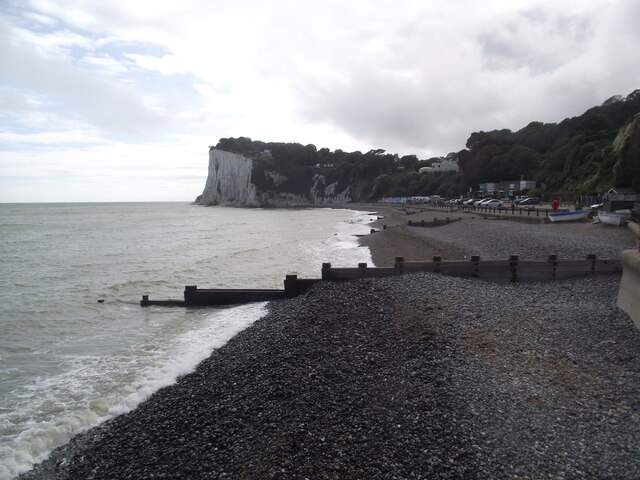
Situated near the town of Folkestone, Leathercoat Point is a popular destination for locals and tourists alike. Its unique geological features make it an interesting site for nature enthusiasts and geologists. The headland is primarily composed of chalk cliffs, which are characteristic of the region's geology.
The point itself is named after a local legend that claims a smuggler known as Leathercoat used to hide his illicit goods in the caves and crevices of the headland. While the caves are now inaccessible due to erosion and safety concerns, the name has stuck and become a part of the area's folklore.
Visitors to Leathercoat Point can enjoy breathtaking views of the surrounding coastline, with panoramic vistas of the English Channel and the nearby White Cliffs of Dover. The area is also known for its diverse wildlife, including seabirds such as gulls and cormorants that nest in the cliffs.
Leathercoat Point is easily accessible, with a public footpath leading to the headland from the nearby village. The site is a popular spot for walking, picnicking, and photography, as well as a starting point for coastal hikes. It offers a unique glimpse into the natural beauty and rich history of the Kent coastline.
If you have any feedback on the listing, please let us know in the comments section below.
Leathercoat Point Images
Images are sourced within 2km of 51.157258/1.3939773 or Grid Reference TR3745. Thanks to Geograph Open Source API. All images are credited.
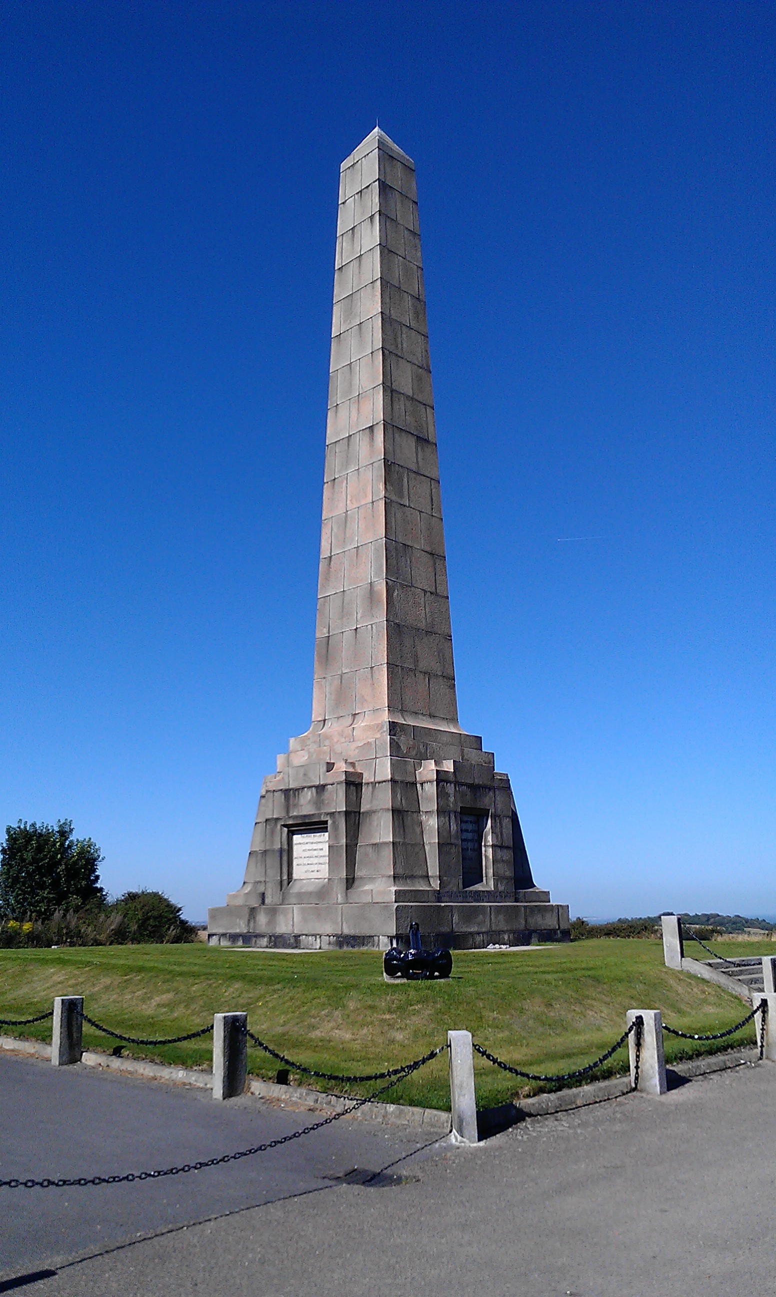
![A walk from St Margaretâs at Cliffe to Kingsdown and return [1] This monument at Leathercoat Point was erected in 1921 as a memorial to the Dover Patrol in WWI. There are identical monuments in France and in New York. Constructed of ashlar blocks, about 80 feet high. Listed, grade II*, with details at: historicengland.org.uk/listing/the-list/list-entry/1070067
Starting from the Dover Patrol Monument, the walk follows the long distance Saxon Shore Way along the top of the cliffs before descending to the bay at Kingsdown. Heading inland there is an ascent of Wood Hill before various rights of way run across fields to the wonderfully named Otty Bottom, then on to Free Down and a return to the starting point. A little more than 5 miles.](https://s0.geograph.org.uk/geophotos/07/08/49/7084960_5fb94790.jpg)
![A walk from St Margaretâs at Cliffe to Kingsdown and return [2] The path heads north along the cliff tops. From here to Kingsdown the path is part of three long distance paths. The England Coast Path, the Saxon Shore Way and the White Cliffs Country Trail.
Starting from the Dover Patrol Monument, the walk follows the long distance Saxon Shore Way along the top of the cliffs before descending to the bay at Kingsdown. Heading inland there is an ascent of Wood Hill before various rights of way run across fields to the wonderfully named Otty Bottom, then on to Free Down and a return to the starting point. A little more than 5 miles.](https://s1.geograph.org.uk/geophotos/07/08/49/7084961_ffab8a6a.jpg)
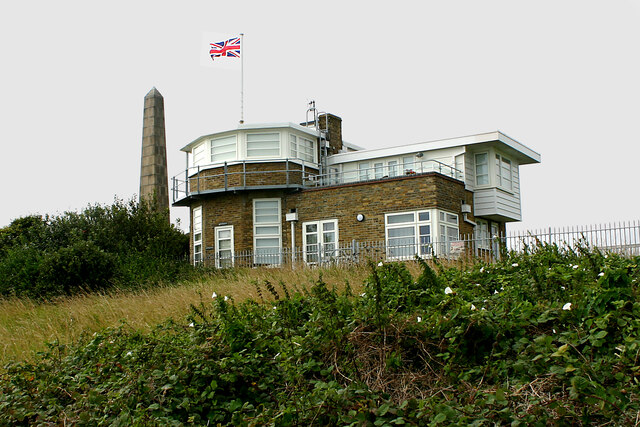
![A walk from St Margaretâs at Cliffe to Kingsdown and return [3] This building appears to be a coastal lookout. On the OS map it is marked as a tearoom.
Starting from the Dover Patrol Monument, the walk follows the long distance Saxon Shore Way along the top of the cliffs before descending to the bay at Kingsdown. Heading inland there is an ascent of Wood Hill before various rights of way run across fields to the wonderfully named Otty Bottom, then on to Free Down and a return to the starting point. A little more than 5 miles.](https://s3.geograph.org.uk/geophotos/07/08/49/7084963_3f47163f.jpg)
![A walk from St Margaretâs at Cliffe to Kingsdown and return [4] North along the cliff top.
Starting from the Dover Patrol Monument, the walk follows the long distance Saxon Shore Way along the top of the cliffs before descending to the bay at Kingsdown. Heading inland there is an ascent of Wood Hill before various rights of way run across fields to the wonderfully named Otty Bottom, then on to Free Down and a return to the starting point. A little more than 5 miles.](https://s0.geograph.org.uk/geophotos/07/08/49/7084964_33d23893.jpg)
![A walk from St Margaretâs at Cliffe to Kingsdown and return [5] Looking north from the path and the first glimpse of white chalk.
Starting from the Dover Patrol Monument, the walk follows the long distance Saxon Shore Way along the top of the cliffs before descending to the bay at Kingsdown. Heading inland there is an ascent of Wood Hill before various rights of way run across fields to the wonderfully named Otty Bottom, then on to Free Down and a return to the starting point. A little more than 5 miles.](https://s1.geograph.org.uk/geophotos/07/08/49/7084965_f29314bb.jpg)
![A walk from St Margaretâs at Cliffe to Kingsdown and return [6] The path continues to head north along the cliff tops. From here to Kingsdown the path is part of three long distance paths. The England Coast Path, the Saxon Shore Way and the White Cliffs Country Trail.
Starting from the Dover Patrol Monument, the walk follows the long distance Saxon Shore Way along the top of the cliffs before descending to the bay at Kingsdown. Heading inland there is an ascent of Wood Hill before various rights of way run across fields to the wonderfully named Otty Bottom, then on to Free Down and a return to the starting point. A little more than 5 miles.](https://s2.geograph.org.uk/geophotos/07/08/49/7084966_a91838df.jpg)
![A walk from St Margaretâs at Cliffe to Kingsdown and return [7] A view back along the path with the Dover Patrol Monument prominent.
Starting from the Dover Patrol Monument, the walk follows the long distance Saxon Shore Way along the top of the cliffs before descending to the bay at Kingsdown. Heading inland there is an ascent of Wood Hill before various rights of way run across fields to the wonderfully named Otty Bottom, then on to Free Down and a return to the starting point. A little more than 5 miles.](https://s3.geograph.org.uk/geophotos/07/08/49/7084967_1b69f27a.jpg)
![A walk from St Margaretâs at Cliffe to Kingsdown and return [8] From the cliff top path, this path branches off and leads to St Margaret's Free Down.
Starting from the Dover Patrol Monument, the walk follows the long distance Saxon Shore Way along the top of the cliffs before descending to the bay at Kingsdown. Heading inland there is an ascent of Wood Hill before various rights of way run across fields to the wonderfully named Otty Bottom, then on to Free Down and a return to the starting point. A little more than 5 miles.](https://s2.geograph.org.uk/geophotos/07/08/49/7084970_96d30c90.jpg)
![A walk from St Margaretâs at Cliffe to Kingsdown and return [9] The path passes through the gate and offers glimpses of the white cliffs in the distance.
Starting from the Dover Patrol Monument, the walk follows the long distance Saxon Shore Way along the top of the cliffs before descending to the bay at Kingsdown. Heading inland there is an ascent of Wood Hill before various rights of way run across fields to the wonderfully named Otty Bottom, then on to Free Down and a return to the starting point. A little more than 5 miles.](https://s0.geograph.org.uk/geophotos/07/08/49/7084972_abb1dccf.jpg)
![A walk from St Margaretâs at Cliffe to Kingsdown and return [10] Seen from the path is this schooner.
Starting from the Dover Patrol Monument, the walk follows the long distance Saxon Shore Way along the top of the cliffs before descending to the bay at Kingsdown. Heading inland there is an ascent of Wood Hill before various rights of way run across fields to the wonderfully named Otty Bottom, then on to Free Down and a return to the starting point. A little more than 5 miles.](https://s1.geograph.org.uk/geophotos/07/08/49/7084973_923d3e8d.jpg)
![A walk from St Margaretâs at Cliffe to Kingsdown and return [11] The path continues north along the cliff top with the odd glimpse of the white chalk.
Starting from the Dover Patrol Monument, the walk follows the long distance Saxon Shore Way along the top of the cliffs before descending to the bay at Kingsdown. Heading inland there is an ascent of Wood Hill before various rights of way run across fields to the wonderfully named Otty Bottom, then on to Free Down and a return to the starting point. A little more than 5 miles.](https://s2.geograph.org.uk/geophotos/07/08/49/7084974_f6d65af9.jpg)
![A walk from St Margaretâs at Cliffe to Kingsdown and return [12] A view out to sea and a bench for the weary walker.
Starting from the Dover Patrol Monument, the walk follows the long distance Saxon Shore Way along the top of the cliffs before descending to the bay at Kingsdown. Heading inland there is an ascent of Wood Hill before various rights of way run across fields to the wonderfully named Otty Bottom, then on to Free Down and a return to the starting point. A little more than 5 miles.](https://s0.geograph.org.uk/geophotos/07/08/56/7085628_40520eae.jpg)
![A walk from St Margaretâs at Cliffe to Kingsdown and return [13] The path continues to head north along the cliff tops.
Starting from the Dover Patrol Monument, the walk follows the long distance Saxon Shore Way along the top of the cliffs before descending to the bay at Kingsdown. Heading inland there is an ascent of Wood Hill before various rights of way run across fields to the wonderfully named Otty Bottom, then on to Free Down and a return to the starting point. A little more than 5 miles.](https://s1.geograph.org.uk/geophotos/07/08/56/7085629_faaf63b6.jpg)
![A walk from St Margaretâs at Cliffe to Kingsdown and return [14] Little Green is a house with a view. Seen from the path.
Starting from the Dover Patrol Monument, the walk follows the long distance Saxon Shore Way along the top of the cliffs before descending to the bay at Kingsdown. Heading inland there is an ascent of Wood Hill before various rights of way run across fields to the wonderfully named Otty Bottom, then on to Free Down and a return to the starting point. A little more than 5 miles.](https://s2.geograph.org.uk/geophotos/07/08/56/7085630_bc548c3c.jpg)
![A walk from St Margaretâs at Cliffe to Kingsdown and return [15] A view south along the path on the top of the cliffs.
Starting from the Dover Patrol Monument, the walk follows the long distance Saxon Shore Way along the top of the cliffs before descending to the bay at Kingsdown. Heading inland there is an ascent of Wood Hill before various rights of way run across fields to the wonderfully named Otty Bottom, then on to Free Down and a return to the starting point. A little more than 5 miles.](https://s1.geograph.org.uk/geophotos/07/08/56/7085633_f676272a.jpg)
Leathercoat Point is located at Grid Ref: TR3745 (Lat: 51.157258, Lng: 1.3939773)
Administrative County: Kent
District: Dover
Police Authority: Kent
What 3 Words
///ambitions.report.cultivation. Near Dover, Kent
Nearby Locations
Related Wikis

Leathercoat Point
Leathercoat Point is a landform in St Margaret's at Cliffe, Kent. The Dover Patrol Monument is located here. == References ==
Dover Patrol
The Dover Patrol and later known as the Dover Patrol Force was a Royal Navy command of the First World War, notable for its involvement in the Zeebrugge...

St Margaret's at Cliffe
St. Margaret's at Cliffe is a three-part village situated just off the coast road between Deal and Dover in Kent, England. The centre of the village is...

Dover to Kingsdown Cliffs
Dover to Kingsdown Cliffs is a 207.7-hectare (513-acre) biological and geological Site of Special Scientific Interest which runs along the Kent coast between...
Nearby Amenities
Located within 500m of 51.157258,1.3939773Have you been to Leathercoat Point?
Leave your review of Leathercoat Point below (or comments, questions and feedback).