Knock Point
Coastal Feature, Headland, Point in Kent Canterbury
England
Knock Point
![Reculver Towers and Roman Fort [1] This millennium cross was carved from Portland Stone. The design is based on the original Reculver Cross, fragments of which survive in Canterbury Cathedral.
Reculver is a village and coastal resort some 3 miles east of Herne Bay in Kent. The village is known for the ruins of a church and for being the site of a Roman fort. During the Middle Ages Reculver was a thriving township with a weekly market and a yearly fair. The village declined, due to coastal erosion and to the Wantsum Channel silting up, and was abandoned in the late 18th century. There was a revival of tourism in the 20th century and there are now two large caravan parks.](https://s3.geograph.org.uk/geophotos/07/05/83/7058379_c97f81df.jpg)
Knock Point is a prominent coastal feature located in Kent, England. Situated on the southeastern coast, it is characterized as a headland or point extending out into the English Channel. The point is part of the larger coastline that stretches from the town of Deal to the village of Kingsdown.
Rising to an elevation of approximately 30 meters above sea level, Knock Point offers stunning panoramic views of the surrounding area. Its strategic position allows visitors to observe the vast expanse of the English Channel, with the French coast visible on clear days. The point is also a popular spot for birdwatching, as it provides an ideal vantage point to observe various seabirds and migratory species.
The geology of Knock Point is mainly composed of chalk cliffs, a characteristic feature of the area. These cliffs, known as the White Cliffs of Dover, are famous for their striking white appearance and have become an iconic symbol of the English coastline. The chalk cliffs also serve as a natural defense against erosion, protecting the land from the powerful forces of the sea.
Knock Point is easily accessible by foot, with a well-maintained coastal path leading to the point from nearby towns. The area surrounding the point is also a designated Site of Special Scientific Interest (SSSI), recognizing its importance for wildlife conservation and geological significance.
Overall, Knock Point in Kent offers visitors a unique opportunity to experience the natural beauty of the English coastline while providing a glimpse into the area's geological and ecological diversity.
If you have any feedback on the listing, please let us know in the comments section below.
Knock Point Images
Images are sourced within 2km of 51.3784/1.2229394 or Grid Reference TR2469. Thanks to Geograph Open Source API. All images are credited.
![Reculver Towers and Roman Fort [2] An information board by English Heritage who manage the site. The site is a Scheduled Ancient Monument with much detail at: <span class="nowrap"><a title="https://historicengland.org.uk/listing/the-list/list-entry/1018784" rel="nofollow ugc noopener" href="https://historicengland.org.uk/listing/the-list/list-entry/1018784">Link</a><img style="margin-left:2px;" alt="External link" title="External link - shift click to open in new window" src="https://s1.geograph.org.uk/img/external.png" width="10" height="10"/></span>
Reculver is a village and coastal resort some 3 miles east of Herne Bay in Kent. The village is known for the ruins of a church and for being the site of a Roman fort. During the Middle Ages Reculver was a thriving township with a weekly market and a yearly fair. The village declined, due to coastal erosion and to the Wantsum Channel silting up, and was abandoned in the late 18th century. There was a revival of tourism in the 20th century and there are now two large caravan parks.](https://s0.geograph.org.uk/geophotos/07/05/83/7058380_0847194f.jpg)
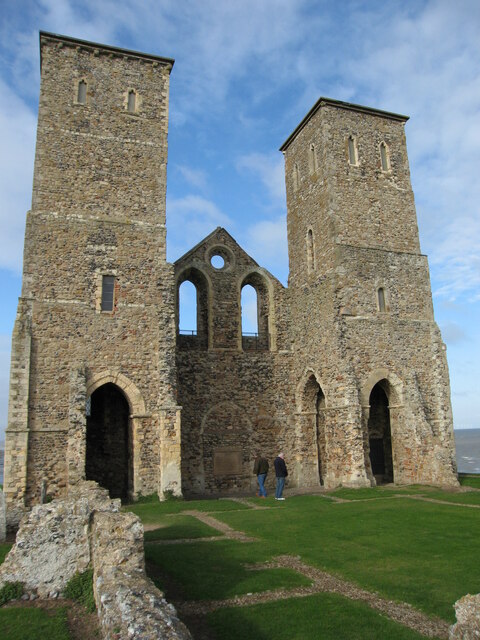
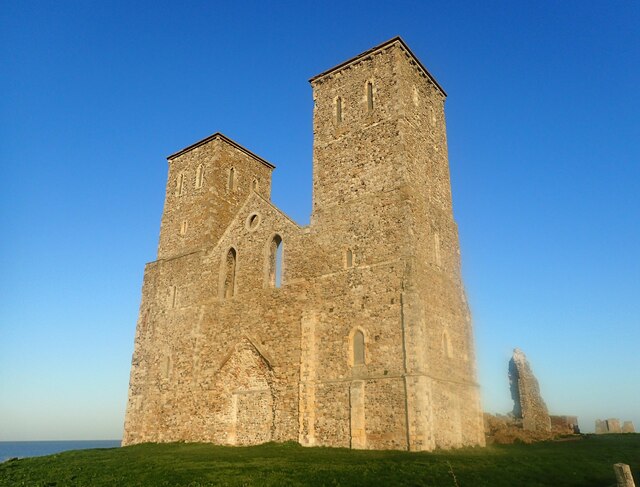
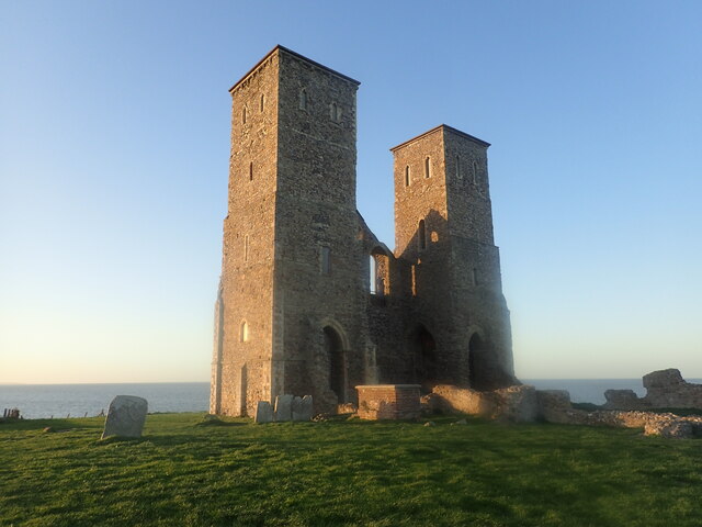
![Reculver Towers and Roman Fort [3] The church of St Mary was founded in 669, it was sited near the centre of the Roman fort, and was built with material from demolished Roman buildings. Greatly expanded in later centuries, the towers were added in the 12th century and there were additions and alteration in the 15th century. Coastal erosion led to the church being demolished in 1809. The remains of the church were purchased by Trinity House as the towers were an important landmark for shipping. The site is a Scheduled Ancient Monument with much detail at: <span class="nowrap"><a title="https://historicengland.org.uk/listing/the-list/list-entry/1018784" rel="nofollow ugc noopener" href="https://historicengland.org.uk/listing/the-list/list-entry/1018784">Link</a><img style="margin-left:2px;" alt="External link" title="External link - shift click to open in new window" src="https://s1.geograph.org.uk/img/external.png" width="10" height="10"/></span>
Reculver is a village and coastal resort some 3 miles east of Herne Bay in Kent. The village is known for the ruins of a church and for being the site of a Roman fort. During the Middle Ages Reculver was a thriving township with a weekly market and a yearly fair. The village declined, due to coastal erosion and to the Wantsum Channel silting up, and was abandoned in the late 18th century. There was a revival of tourism in the 20th century and there are now two large caravan parks.](https://s1.geograph.org.uk/geophotos/07/05/83/7058381_811c1f0f.jpg)
![Reculver Towers and Roman Fort [4] The church of St Mary was founded in 669, it was sited near the centre of the Roman fort, and was built with material from demolished Roman buildings. Greatly expanded in later centuries, the towers were added in the 12th century and there were additions and alteration in the 15th century. Coastal erosion led to the church being demolished in 1809. The remains of the church were purchased by Trinity House as the towers were an important landmark for shipping. The site is a Scheduled Ancient Monument with much detail at: <span class="nowrap"><a title="https://historicengland.org.uk/listing/the-list/list-entry/1018784" rel="nofollow ugc noopener" href="https://historicengland.org.uk/listing/the-list/list-entry/1018784">Link</a><img style="margin-left:2px;" alt="External link" title="External link - shift click to open in new window" src="https://s1.geograph.org.uk/img/external.png" width="10" height="10"/></span>
Reculver is a village and coastal resort some 3 miles east of Herne Bay in Kent. The village is known for the ruins of a church and for being the site of a Roman fort. During the Middle Ages Reculver was a thriving township with a weekly market and a yearly fair. The village declined, due to coastal erosion and to the Wantsum Channel silting up, and was abandoned in the late 18th century. There was a revival of tourism in the 20th century and there are now two large caravan parks.](https://s2.geograph.org.uk/geophotos/07/05/83/7058382_9522f557.jpg)
![Reculver Towers and Roman Fort [5] From near the ruins of the church is this view across the interior of the fort.
Reculver once occupied a strategic location at the northwestern end of the Wantsum Channel, a sea lane that separated the Isle of Thanet and the Kent mainland. The Romans built a small fort in 43 AD, and, late in the 2nd century, built a larger fort, called Regulbium, which later became one of the chain of Saxon Shore forts. Much of the fort has been lost to coastal erosion. The site is a Scheduled Ancient Monument with much detail at: <span class="nowrap"><a title="https://historicengland.org.uk/listing/the-list/list-entry/1018784" rel="nofollow ugc noopener" href="https://historicengland.org.uk/listing/the-list/list-entry/1018784">Link</a><img style="margin-left:2px;" alt="External link" title="External link - shift click to open in new window" src="https://s1.geograph.org.uk/img/external.png" width="10" height="10"/></span>
Reculver is a village and coastal resort some 3 miles east of Herne Bay in Kent. The village is known for the ruins of a church and for being the site of a Roman fort. During the Middle Ages Reculver was a thriving township with a weekly market and a yearly fair. The village declined, due to coastal erosion and to the Wantsum Channel silting up, and was abandoned in the late 18th century. There was a revival of tourism in the 20th century and there are now two large caravan parks.](https://s3.geograph.org.uk/geophotos/07/05/83/7058383_ce2ee88b.jpg)
![Reculver Towers and Roman Fort [6] An information board about the change to the landscape due to the silting up of the Wantsum Channel.
Reculver once occupied a strategic location at the northwestern end of the Wantsum Channel, a sea lane that separated the Isle of Thanet and the Kent mainland. The Romans built a small fort in 43 AD, and, late in the 2nd century, built a larger fort, called Regulbium, which later became one of the chain of Saxon Shore forts. Much of the fort has been lost to coastal erosion. The site is a Scheduled Ancient Monument with much detail at: <span class="nowrap"><a title="https://historicengland.org.uk/listing/the-list/list-entry/1018784" rel="nofollow ugc noopener" href="https://historicengland.org.uk/listing/the-list/list-entry/1018784">Link</a><img style="margin-left:2px;" alt="External link" title="External link - shift click to open in new window" src="https://s1.geograph.org.uk/img/external.png" width="10" height="10"/></span>
Reculver is a village and coastal resort some 3 miles east of Herne Bay in Kent. The village is known for the ruins of a church and for being the site of a Roman fort. During the Middle Ages Reculver was a thriving township with a weekly market and a yearly fair. The village declined, due to coastal erosion and to the Wantsum Channel silting up, and was abandoned in the late 18th century. There was a revival of tourism in the 20th century and there are now two large caravan parks.](https://s0.geograph.org.uk/geophotos/07/05/83/7058384_66093fbe.jpg)
![Reculver Towers and Roman Fort [7] An information board about the east gate of the fort.
Reculver once occupied a strategic location at the northwestern end of the Wantsum Channel, a sea lane that separated the Isle of Thanet and the Kent mainland. The Romans built a small fort in 43 AD, and, late in the 2nd century, built a larger fort, called Regulbium, which later became one of the chain of Saxon Shore forts. Much of the fort has been lost to coastal erosion. The site is a Scheduled Ancient Monument with much detail at: <span class="nowrap"><a title="https://historicengland.org.uk/listing/the-list/list-entry/1018784" rel="nofollow ugc noopener" href="https://historicengland.org.uk/listing/the-list/list-entry/1018784">Link</a><img style="margin-left:2px;" alt="External link" title="External link - shift click to open in new window" src="https://s1.geograph.org.uk/img/external.png" width="10" height="10"/></span>
Reculver is a village and coastal resort some 3 miles east of Herne Bay in Kent. The village is known for the ruins of a church and for being the site of a Roman fort. During the Middle Ages Reculver was a thriving township with a weekly market and a yearly fair. The village declined, due to coastal erosion and to the Wantsum Channel silting up, and was abandoned in the late 18th century. There was a revival of tourism in the 20th century and there are now two large caravan parks.](https://s1.geograph.org.uk/geophotos/07/05/83/7058385_a7211b4b.jpg)
![Reculver Towers and Roman Fort [8] The remains of the east gate of the fort.
Reculver once occupied a strategic location at the northwestern end of the Wantsum Channel, a sea lane that separated the Isle of Thanet and the Kent mainland. The Romans built a small fort in 43 AD, and, late in the 2nd century, built a larger fort, called Regulbium, which later became one of the chain of Saxon Shore forts. Much of the fort has been lost to coastal erosion. The site is a Scheduled Ancient Monument with much detail at: <span class="nowrap"><a title="https://historicengland.org.uk/listing/the-list/list-entry/1018784" rel="nofollow ugc noopener" href="https://historicengland.org.uk/listing/the-list/list-entry/1018784">Link</a><img style="margin-left:2px;" alt="External link" title="External link - shift click to open in new window" src="https://s1.geograph.org.uk/img/external.png" width="10" height="10"/></span>
Reculver is a village and coastal resort some 3 miles east of Herne Bay in Kent. The village is known for the ruins of a church and for being the site of a Roman fort. During the Middle Ages Reculver was a thriving township with a weekly market and a yearly fair. The village declined, due to coastal erosion and to the Wantsum Channel silting up, and was abandoned in the late 18th century. There was a revival of tourism in the 20th century and there are now two large caravan parks.](https://s2.geograph.org.uk/geophotos/07/05/83/7058386_12b23c14.jpg)
![Reculver Towers and Roman Fort [9] The remains of the guardhouse at the east gate of the fort.
Reculver once occupied a strategic location at the northwestern end of the Wantsum Channel, a sea lane that separated the Isle of Thanet and the Kent mainland. The Romans built a small fort in 43 AD, and, late in the 2nd century, built a larger fort, called Regulbium, which later became one of the chain of Saxon Shore forts. Much of the fort has been lost to coastal erosion. The site is a Scheduled Ancient Monument with much detail at: <span class="nowrap"><a title="https://historicengland.org.uk/listing/the-list/list-entry/1018784" rel="nofollow ugc noopener" href="https://historicengland.org.uk/listing/the-list/list-entry/1018784">Link</a><img style="margin-left:2px;" alt="External link" title="External link - shift click to open in new window" src="https://s1.geograph.org.uk/img/external.png" width="10" height="10"/></span>
Reculver is a village and coastal resort some 3 miles east of Herne Bay in Kent. The village is known for the ruins of a church and for being the site of a Roman fort. During the Middle Ages Reculver was a thriving township with a weekly market and a yearly fair. The village declined, due to coastal erosion and to the Wantsum Channel silting up, and was abandoned in the late 18th century. There was a revival of tourism in the 20th century and there are now two large caravan parks.](https://s3.geograph.org.uk/geophotos/07/05/83/7058387_e5a863d2.jpg)
![Reculver Towers and Roman Fort [10] Two odd, isolated buildings in a field to the east of the fort. Purpose unknown.
Reculver is a village and coastal resort some 3 miles east of Herne Bay in Kent. The village is known for the ruins of a church and for being the site of a Roman fort. During the Middle Ages Reculver was a thriving township with a weekly market and a yearly fair. The village declined, due to coastal erosion and to the Wantsum Channel silting up, and was abandoned in the late 18th century. There was a revival of tourism in the 20th century and there are now two large caravan parks.](https://s1.geograph.org.uk/geophotos/07/05/83/7058389_d375796f.jpg)
![Reculver Towers and Roman Fort [11] The church of St Mary was founded in 669, it was sited near the centre of the Roman fort, and was built with material from demolished Roman buildings. Greatly expanded in later centuries, the towers were added in the 12th century and there were additions and alteration in the 15th century. Coastal erosion led to the church being demolished in 1809. The remains of the church were purchased by Trinity House as the towers were an important landmark for shipping. The site is a Scheduled Ancient Monument with much detail at: <span class="nowrap"><a title="https://historicengland.org.uk/listing/the-list/list-entry/1018784" rel="nofollow ugc noopener" href="https://historicengland.org.uk/listing/the-list/list-entry/1018784">Link</a><img style="margin-left:2px;" alt="External link" title="External link - shift click to open in new window" src="https://s1.geograph.org.uk/img/external.png" width="10" height="10"/></span>
Reculver is a village and coastal resort some 3 miles east of Herne Bay in Kent. The village is known for the ruins of a church and for being the site of a Roman fort. During the Middle Ages Reculver was a thriving township with a weekly market and a yearly fair. The village declined, due to coastal erosion and to the Wantsum Channel silting up, and was abandoned in the late 18th century. There was a revival of tourism in the 20th century and there are now two large caravan parks.](https://s3.geograph.org.uk/geophotos/07/05/83/7058391_14dd80e0.jpg)
![Reculver Towers and Roman Fort [12] Looking east along the coast from the ruins of the church.
Reculver is a village and coastal resort some 3 miles east of Herne Bay in Kent. The village is known for the ruins of a church and for being the site of a Roman fort. During the Middle Ages Reculver was a thriving township with a weekly market and a yearly fair. The village declined, due to coastal erosion and to the Wantsum Channel silting up, and was abandoned in the late 18th century. There was a revival of tourism in the 20th century and there are now two large caravan parks.](https://s1.geograph.org.uk/geophotos/07/05/83/7058393_a9342aff.jpg)
![Reculver Towers and Roman Fort [14] Looking west along the coast from the ruins of the church.
Reculver is a village and coastal resort some 3 miles east of Herne Bay in Kent. The village is known for the ruins of a church and for being the site of a Roman fort. During the Middle Ages Reculver was a thriving township with a weekly market and a yearly fair. The village declined, due to coastal erosion and to the Wantsum Channel silting up, and was abandoned in the late 18th century. There was a revival of tourism in the 20th century and there are now two large caravan parks.](https://s0.geograph.org.uk/geophotos/07/05/83/7058396_d8d972d5.jpg)
![Reculver Towers and Roman Fort [15] A plaque in the ruins of the church.
The church of St Mary was founded in 669, it was sited near the centre of the Roman fort, and was built with material from demolished Roman buildings. Greatly expanded in later centuries, the towers were added in the 12th century and there were additions and alteration in the 15th century. Coastal erosion led to the church being demolished in 1809. The remains of the church were purchased by Trinity House as the towers were an important landmark for shipping. The site is a Scheduled Ancient Monument with much detail at: <span class="nowrap"><a title="https://historicengland.org.uk/listing/the-list/list-entry/1018784" rel="nofollow ugc noopener" href="https://historicengland.org.uk/listing/the-list/list-entry/1018784">Link</a><img style="margin-left:2px;" alt="External link" title="External link - shift click to open in new window" src="https://s1.geograph.org.uk/img/external.png" width="10" height="10"/></span>
Reculver is a village and coastal resort some 3 miles east of Herne Bay in Kent. The village is known for the ruins of a church and for being the site of a Roman fort. During the Middle Ages Reculver was a thriving township with a weekly market and a yearly fair. The village declined, due to coastal erosion and to the Wantsum Channel silting up, and was abandoned in the late 18th century. There was a revival of tourism in the 20th century and there are now two large caravan parks.](https://s3.geograph.org.uk/geophotos/07/05/83/7058399_4eb505f8.jpg)
![Reculver Towers and Roman Fort [16] The church of St Mary was founded in 669, it was sited near the centre of the Roman fort, and was built with material from demolished Roman buildings. Greatly expanded in later centuries, the towers were added in the 12th century and there were additions and alteration in the 15th century. Coastal erosion led to the church being demolished in 1809. The remains of the church were purchased by Trinity House as the towers were an important landmark for shipping. The site is a Scheduled Ancient Monument with much detail at: <span class="nowrap"><a title="https://historicengland.org.uk/listing/the-list/list-entry/1018784" rel="nofollow ugc noopener" href="https://historicengland.org.uk/listing/the-list/list-entry/1018784">Link</a><img style="margin-left:2px;" alt="External link" title="External link - shift click to open in new window" src="https://s1.geograph.org.uk/img/external.png" width="10" height="10"/></span>
Reculver is a village and coastal resort some 3 miles east of Herne Bay in Kent. The village is known for the ruins of a church and for being the site of a Roman fort. During the Middle Ages Reculver was a thriving township with a weekly market and a yearly fair. The village declined, due to coastal erosion and to the Wantsum Channel silting up, and was abandoned in the late 18th century. There was a revival of tourism in the 20th century and there are now two large caravan parks.](https://s1.geograph.org.uk/geophotos/07/05/84/7058401_c43ee88d.jpg)
Knock Point is located at Grid Ref: TR2469 (Lat: 51.3784, Lng: 1.2229394)
Administrative County: Kent
District: Canterbury
Police Authority: Kent
What 3 Words
///fidelity.dissolves.ghost. Near Birchington-on-Sea, Kent
Nearby Locations
Related Wikis

River Wantsum
The River Wantsum is a tributary of the River Stour, in Kent, England. Formerly, the River Wantsum and the River Stour together formed the Wantsum Channel...

Wantsum Channel
The Wantsum Channel was a strait separating the Isle of Thanet from the north-eastern extremity of the English county of Kent and connecting the English...

Regulbium
Regulbium was the name of an ancient Roman fort of the Saxon Shore in the vicinity of the modern English resort of Reculver in Kent. Its name derives from...

St Mary's Church, Reculver
St Mary's Church, Reculver, was founded in the 7th century as either a minster or a monastery on the site of a Roman fort at Reculver, which was then at...
Nearby Amenities
Located within 500m of 51.3784,1.2229394Have you been to Knock Point?
Leave your review of Knock Point below (or comments, questions and feedback).