Rock Point

Coastal Feature, Headland, Point in Lancashire Barrow-in-Furness

England

Rock Point

Duddon Sands
Duddon Sands Credit: Neil Theasby

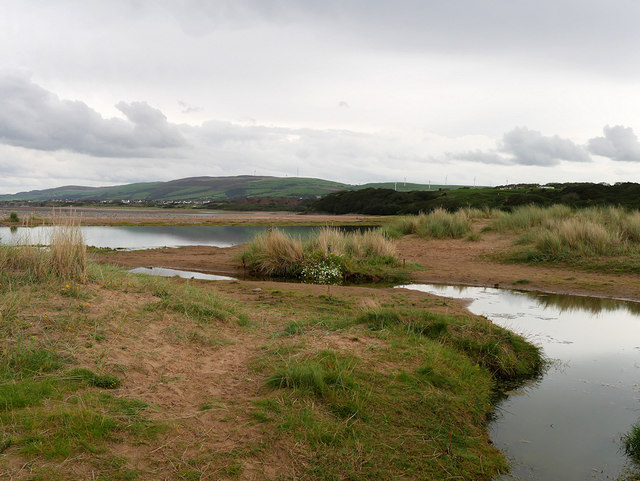
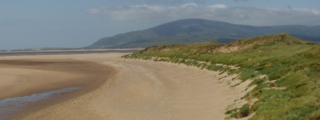
Rock Point is a prominent headland located along the coast of Lancashire, England. Situated on the western side of the county, specifically in the Borough of Wyre, Rock Point is a captivating coastal feature that attracts locals and tourists alike.

Rising majestically above the Irish Sea, Rock Point offers breathtaking panoramic views of the surrounding landscape. The headland is characterized by its rugged cliffs, which are composed of various types of sedimentary rock, giving the area its name. The cliffs showcase intricate layers of shale, sandstone, and limestone, providing geologists with valuable insights into the area's geological history.

The headland's unique geography has made it a popular destination for outdoor enthusiasts. Hiking trails wind their way through the surrounding countryside, offering visitors the opportunity to explore the area's natural beauty. Additionally, Rock Point is an excellent spot for birdwatching, as it serves as a resting place for numerous seabirds during migration seasons.

Rock Point is also known for its historical significance. The headland boasts remnants of ancient fortifications, including a 19th-century Martello tower, which was built to defend against potential invasions. These historical landmarks add to the charm and allure of the area, attracting history enthusiasts and curious visitors.

In conclusion, Rock Point is a captivating and historically significant headland located along the Lancashire coast. With its stunning cliffs, diverse geology, and rich history, it continues to be a popular destination for nature lovers and history enthusiasts alike.

If you have any feedback on the listing, please let us know in the comments section below.

Rock Point Images

Images are sourced within 2km of 54.166008/-3.2045497 or Grid Reference SD2175. Thanks to Geograph Open Source API. All images are credited.

Duddon Sands
Duddon Sands
Sandscale Haws A National Trust property incorporating beach and dunes, here showing the inland side of the dune belt.
Sandscale Haws
A National Trust property incorporating beach and dunes, here showing the inland side of the dune belt.
Duddon Sands and Black Combe Looking from Sandscale Haws across the mouth of the Duddon estuary to the Millom peninsula and Black Combe <a href="https://www.geograph.org.uk/gridref/SD1385">SD1385</a> the southernmost peak of the Lake District.
Duddon Sands and Black Combe
Looking from Sandscale Haws across the mouth of the Duddon estuary to the Millom peninsula and Black Combe SD1385 the southernmost peak of the Lake District.
Boardwalk to the beach On the Sandscale Haws National Trust property. Dead ahead across the Duddon estuary is Black Combe <a href="https://www.geograph.org.uk/gridref/SD1385">SD1385</a> the southernmost peak of the Lake District.
Boardwalk to the beach
On the Sandscale Haws National Trust property. Dead ahead across the Duddon estuary is Black Combe SD1385 the southernmost peak of the Lake District.
Memorial bench at Sandscale Haws Bench dedicated to Vicky Cooney, a National Trust ranger. The car park for the NT property can be seen beyond.
Memorial bench at Sandscale Haws
Bench dedicated to Vicky Cooney, a National Trust ranger. The car park for the NT property can be seen beyond.
Sandscale Haws Nature Reserve Sandscale Haws is a national nature reserve on the Duddon Estuary, part of the Duddon Estuary Site of Special Scientific Interest, providing high tide roosts for waders and wildfowl. It is managed by the National Trust. 

A significant area for Natterjack Toads, Sandscale Haws supports one quarter of the national population of the rare amphibian, which is only found at a few other sites in the UK. There are also migratory bird populations of international importance, including Pintail, Red Knot and Common Redshank. Over 20,000 wintering waterfowl can be seen regularly. All the dune grasslands at Sandscale Haws support a rich flora including the very rare Dune Helleborine.
Sandscale Haws Nature Reserve
Sandscale Haws is a national nature reserve on the Duddon Estuary, part of the Duddon Estuary Site of Special Scientific Interest, providing high tide roosts for waders and wildfowl. It is managed by the National Trust. A significant area for Natterjack Toads, Sandscale Haws supports one quarter of the national population of the rare amphibian, which is only found at a few other sites in the UK. There are also migratory bird populations of international importance, including Pintail, Red Knot and Common Redshank. Over 20,000 wintering waterfowl can be seen regularly. All the dune grasslands at Sandscale Haws support a rich flora including the very rare Dune Helleborine.
Sandscale Haws Sandscale Haws is a national nature reserve on the Duddon Estuary, part of the Duddon Estuary Site of Special Scientific Interest, providing high tide roosts for waders and wildfowl. It is managed by the National Trust. 

A significant area for Natterjack Toads, Sandscale Haws supports one quarter of the national population of the rare amphibian, which is only found at a few other sites in the UK. There are also migratory bird populations of international importance, including Pintail, Red Knot and Common Redshank. Over 20,000 wintering waterfowl can be seen regularly. All the dune grasslands at Sandscale Haws support a rich flora including the very rare Dune Helleborine.
Sandscale Haws
Sandscale Haws is a national nature reserve on the Duddon Estuary, part of the Duddon Estuary Site of Special Scientific Interest, providing high tide roosts for waders and wildfowl. It is managed by the National Trust. A significant area for Natterjack Toads, Sandscale Haws supports one quarter of the national population of the rare amphibian, which is only found at a few other sites in the UK. There are also migratory bird populations of international importance, including Pintail, Red Knot and Common Redshank. Over 20,000 wintering waterfowl can be seen regularly. All the dune grasslands at Sandscale Haws support a rich flora including the very rare Dune Helleborine.
Sandscale Haws, Roanhead Beach Sandscale Haws is a national nature reserve on the Duddon Estuary, part of the Duddon Estuary Site of Special Scientific Interest, providing high tide roosts for waders and wildfowl. It is managed by the National Trust. 

A significant area for Natterjack Toads, Sandscale Haws supports one quarter of the national population of the rare amphibian, which is only found at a few other sites in the UK. There are also migratory bird populations of international importance, including Pintail, Red Knot and Common Redshank. Over 20,000 wintering waterfowl can be seen regularly. All the dune grasslands at Sandscale Haws support a rich flora including the very rare Dune Helleborine.
Sandscale Haws, Roanhead Beach
Sandscale Haws is a national nature reserve on the Duddon Estuary, part of the Duddon Estuary Site of Special Scientific Interest, providing high tide roosts for waders and wildfowl. It is managed by the National Trust. A significant area for Natterjack Toads, Sandscale Haws supports one quarter of the national population of the rare amphibian, which is only found at a few other sites in the UK. There are also migratory bird populations of international importance, including Pintail, Red Knot and Common Redshank. Over 20,000 wintering waterfowl can be seen regularly. All the dune grasslands at Sandscale Haws support a rich flora including the very rare Dune Helleborine.
Sandscale Haws, Duddon Sands Sandscale Haws is a national nature reserve on the Duddon Estuary, part of the Duddon Estuary Site of Special Scientific Interest, providing high tide roosts for waders and wildfowl. It is managed by the National Trust. 

A significant area for Natterjack Toads, Sandscale Haws supports one quarter of the national population of the rare amphibian, which is only found at a few other sites in the UK. There are also migratory bird populations of international importance, including Pintail, Red Knot and Common Redshank. Over 20,000 wintering waterfowl can be seen regularly. All the dune grasslands at Sandscale Haws support a rich flora including the very rare Dune Helleborine.
Sandscale Haws, Duddon Sands
Sandscale Haws is a national nature reserve on the Duddon Estuary, part of the Duddon Estuary Site of Special Scientific Interest, providing high tide roosts for waders and wildfowl. It is managed by the National Trust. A significant area for Natterjack Toads, Sandscale Haws supports one quarter of the national population of the rare amphibian, which is only found at a few other sites in the UK. There are also migratory bird populations of international importance, including Pintail, Red Knot and Common Redshank. Over 20,000 wintering waterfowl can be seen regularly. All the dune grasslands at Sandscale Haws support a rich flora including the very rare Dune Helleborine.
Duddon Sands, Roanhead Beach Sandscale Haws is a national nature reserve on the Duddon Estuary, part of the Duddon Estuary Site of Special Scientific Interest, providing high tide roosts for waders and wildfowl. It is managed by the National Trust. 

A significant area for Natterjack Toads, Sandscale Haws supports one quarter of the national population of the rare amphibian, which is only found at a few other sites in the UK. There are also migratory bird populations of international importance, including Pintail, Red Knot and Common Redshank. Over 20,000 wintering waterfowl can be seen regularly. All the dune grasslands at Sandscale Haws support a rich flora including the very rare Dune Helleborine.
Duddon Sands, Roanhead Beach
Sandscale Haws is a national nature reserve on the Duddon Estuary, part of the Duddon Estuary Site of Special Scientific Interest, providing high tide roosts for waders and wildfowl. It is managed by the National Trust. A significant area for Natterjack Toads, Sandscale Haws supports one quarter of the national population of the rare amphibian, which is only found at a few other sites in the UK. There are also migratory bird populations of international importance, including Pintail, Red Knot and Common Redshank. Over 20,000 wintering waterfowl can be seen regularly. All the dune grasslands at Sandscale Haws support a rich flora including the very rare Dune Helleborine.
Duddon Estuary, Sandscale Haws Sandscale Haws is a national nature reserve on the Duddon Estuary, part of the Duddon Estuary Site of Special Scientific Interest, providing high tide roosts for waders and wildfowl. It is managed by the National Trust. 

A significant area for Natterjack Toads, Sandscale Haws supports one quarter of the national population of the rare amphibian, which is only found at a few other sites in the UK. There are also migratory bird populations of international importance, including Pintail, Red Knot and Common Redshank. Over 20,000 wintering waterfowl can be seen regularly. All the dune grasslands at Sandscale Haws support a rich flora including the very rare Dune Helleborine.
Duddon Estuary, Sandscale Haws
Sandscale Haws is a national nature reserve on the Duddon Estuary, part of the Duddon Estuary Site of Special Scientific Interest, providing high tide roosts for waders and wildfowl. It is managed by the National Trust. A significant area for Natterjack Toads, Sandscale Haws supports one quarter of the national population of the rare amphibian, which is only found at a few other sites in the UK. There are also migratory bird populations of international importance, including Pintail, Red Knot and Common Redshank. Over 20,000 wintering waterfowl can be seen regularly. All the dune grasslands at Sandscale Haws support a rich flora including the very rare Dune Helleborine.
Boardwalk at Sandscale Haws Sandscale Haws is a national nature reserve on the Duddon Estuary, part of the Duddon Estuary Site of Special Scientific Interest, providing high tide roosts for waders and wildfowl. It is managed by the National Trust. 

A significant area for Natterjack Toads, Sandscale Haws supports one quarter of the national population of the rare amphibian, which is only found at a few other sites in the UK. There are also migratory bird populations of international importance, including Pintail, Red Knot and Common Redshank. Over 20,000 wintering waterfowl can be seen regularly. All the dune grasslands at Sandscale Haws support a rich flora including the very rare Dune Helleborine.
Boardwalk at Sandscale Haws
Sandscale Haws is a national nature reserve on the Duddon Estuary, part of the Duddon Estuary Site of Special Scientific Interest, providing high tide roosts for waders and wildfowl. It is managed by the National Trust. A significant area for Natterjack Toads, Sandscale Haws supports one quarter of the national population of the rare amphibian, which is only found at a few other sites in the UK. There are also migratory bird populations of international importance, including Pintail, Red Knot and Common Redshank. Over 20,000 wintering waterfowl can be seen regularly. All the dune grasslands at Sandscale Haws support a rich flora including the very rare Dune Helleborine.
Sandscale Haws, a Lakeland View In addition to the flora and fauna, the walks at Sandscale Haws also provide some spectacular views over the Duddon Estuary, towards the Lake District fells. There is an interpretation board near the car park, to help visitors to identify the different peaks.
Sandscale Haws, a Lakeland View
In addition to the flora and fauna, the walks at Sandscale Haws also provide some spectacular views over the Duddon Estuary, towards the Lake District fells. There is an interpretation board near the car park, to help visitors to identify the different peaks.
Sculpture At Roanhead Beach Carpark This area is also a nature reserve for the Natterjack Toad!
Sculpture At Roanhead Beach Carpark
This area is also a nature reserve for the Natterjack Toad!
Sunlit Mudflats Looking west towards a hazy setting sun
Sunlit Mudflats
Looking west towards a hazy setting sun
Roanhead Sands from the dunes Black Combe is seen in the distance over the Duddon Estuary
Roanhead Sands from the dunes
Black Combe is seen in the distance over the Duddon Estuary
Dunes near Sandscale Haws This small area of sand dunes between the National Trust car park and the beach is protected from walkers by barriers. The distant windfarm (centre left) is on Hare Slack Hill (<a href="https://www.geograph.org.uk/gridref/SD2377">SD2377</a>)
Dunes near Sandscale Haws
This small area of sand dunes between the National Trust car park and the beach is protected from walkers by barriers. The distant windfarm (centre left) is on Hare Slack Hill (SD2377)
Duddon Sands near Sandscale Haws At the high water mark on Duddon Sands. The windfarm (right) is on Hare Slack Hill (<a href="https://www.geograph.org.uk/gridref/SD2377">SD2377</a>); the hill (centre) is the ridge of Bank House Moor
Duddon Sands near Sandscale Haws
At the high water mark on Duddon Sands. The windfarm (right) is on Hare Slack Hill (SD2377); the hill (centre) is the ridge of Bank House Moor
Show me another place!

Rock Point is located at Grid Ref: SD2175 (Lat: 54.166008, Lng: -3.2045497)

Administrative County: Cumbria

District: Barrow-in-Furness

Police Authority: Cumbria

What 3 Words

///swelling.passports.curtains. Near Dalton in Furness, Cumbria

Related Wikis

Dowdales School

Dowdales School which was founded 1928, is a community, comprehensive school in Dalton-in-Furness, Cumbria for anyone, in the age range 11–16. There are...

Dalton Castle, Cumbria

Dalton Castle is a grade I listed 14th-century peel tower situated in Dalton-in-Furness, Cumbria, England, and in the ownership of the National Trust....

St Mary's Church, Dalton-in-Furness

St Mary's Church is in the town of Dalton-in-Furness, Cumbria, England. It is an active Anglican parish church in the deanery of Furness, the archdeaconry...

Dalton-in-Furness

Dalton-in-Furness is a town and former civil parish, now in the parish of Dalton Town with Newton, in the Westmorland and Furness district, in the ceremonial...

Dalton North

Dalton North is a ward of the British town Dalton-in-Furness, within the Borough of Barrow-in-Furness. With 6,599 people residing in Dalton North in 2001...

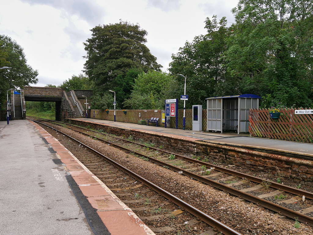
Dalton railway station

Dalton is a railway station on the Furness Line, which runs between Barrow-in-Furness and Lancaster. The station, situated 5 miles (8 km) north-east of...

South Lakes Safari Zoo

South Lakes Safari Zoo (formerly South Lakes Wild Animal Park) is a 51-acre (21 ha) zoo established in 1994 by David Gill, and located in Cumbria, England...

Roanhead

Roanhead (sometimes spelled Ronhead) refers to the limestone outcrop of Roanhead Crag in Cumbria and the farmland behind it, but in recent years the term...

Nearby Amenities

Located within 500m of 54.166008,-3.2045497
Barrier: cattle_grid
Lat/Long: 54.1683867/-3.2018601
Barrier: cattle_grid
Lat/Long: 54.1624122/-3.200373
Railway: level_crossing
Lat/Long: 54.1681834/-3.2024284
Generator Method: wind_turbine
Generator Source: wind
Power: generator
Lat/Long: 54.1657094/-3.2064881
Railway: level_crossing
Lat/Long: 54.1681919/-3.2024735
Power: pole
Lat/Long: 54.1623324/-3.2062283
Power: pole
Lat/Long: 54.1617862/-3.2058409
Power: pole
Lat/Long: 54.161762/-3.2058145
Power: pole
Lat/Long: 54.164128/-3.1976606
Power: pole
Lat/Long: 54.1646213/-3.1981872
Power: pole
Lat/Long: 54.1651308/-3.1987515
Power: pole
Lat/Long: 54.1655918/-3.199243
Power: pole
Lat/Long: 54.1663156/-3.200058
Power: pole
Lat/Long: 54.1666885/-3.2004517
Power: pole
Lat/Long: 54.1680039/-3.2017006
Power: pole
Lat/Long: 54.1682123/-3.2013971
Power: pole
Lat/Long: 54.1685118/-3.2009959
Power: pole
Lat/Long: 54.1688304/-3.2005897
The data included in this document is from www.openstreetmap.org. The data is made available under ODbL.

Have you been to Rock Point?

Leave your review of Rock Point below (or comments, questions and feedback).