Àird Chaol

Landscape Feature in Ross-shire

Scotland

Àird Chaol

Rocks on Druim Raois Outcropping rock and boulders litter the moorland below Mealaisbhal.
Rocks on Druim Raois Credit: Alan Reid

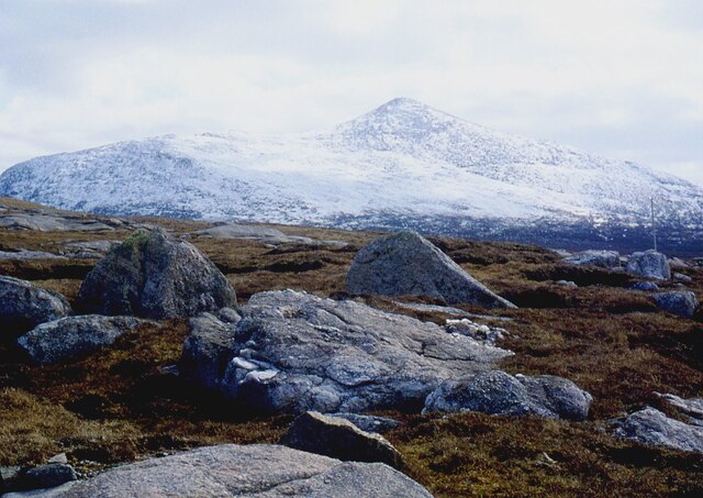
Àird Chaol is a picturesque landscape feature located in Ross-shire, Scotland. Situated on the west coast of Scotland, it is known for its stunning natural beauty and breathtaking views of the surrounding area. The name Àird Chaol translates to "narrow headland" in Gaelic, which perfectly describes the physical topography of this area.

The landscape of Àird Chaol is characterized by rugged cliffs, rolling hills, and pristine beaches. The headland itself juts out into the sea, creating a dramatic and striking feature that is beloved by locals and visitors alike. The coastline is dotted with small coves and hidden bays, providing ample opportunities for exploration and discovery.

The area is also known for its diverse wildlife. Seabirds such as gannets, puffins, and cormorants can be seen nesting on the cliffs, while seals and dolphins can often be spotted in the surrounding waters. The flora of Àird Chaol is equally impressive, with heather-covered hillsides and wildflowers adding vibrant splashes of color to the landscape.

In addition to its natural beauty, Àird Chaol has a rich history. The ruins of an ancient castle can be found perched on the cliffs, serving as a reminder of the area's past. The castle is said to have been built in the 13th century and has since become a popular tourist attraction.

Overall, Àird Chaol is a captivating and picturesque landscape feature that offers a unique combination of natural beauty, wildlife, and historical significance. It is a must-visit destination for nature lovers and history enthusiasts alike.

If you have any feedback on the listing, please let us know in the comments section below.

Àird Chaol Images

Images are sourced within 2km of 58.154264/-7.0503351 or Grid Reference NB0329. Thanks to Geograph Open Source API. All images are credited.

Rocks on Druim Raois Outcropping rock and boulders litter the moorland below Mealaisbhal.
Rocks on Druim Raois
Outcropping rock and boulders litter the moorland below Mealaisbhal.
A pretty lochan This is Lochan Mealabhat, two thirds of which is in this square. It is a pleasing geograph photo, because it clearly shows what you can see on the map: I'm standing on a little tongue of land that sticks out into the lochan, the tongue is in the square, and I'm looking across to a similar tongue.
A pretty lochan
This is Lochan Mealabhat, two thirds of which is in this square. It is a pleasing geograph photo, because it clearly shows what you can see on the map: I'm standing on a little tongue of land that sticks out into the lochan, the tongue is in the square, and I'm looking across to a similar tongue.
Loch Mòr na Clibhe A view across Loch Mòr na Clibhe from the track before it goes round Loch Reonasgail.
Loch Mòr na Clibhe
A view across Loch Mòr na Clibhe from the track before it goes round Loch Reonasgail.
Terrain At Edge of Track Distant view from track towards Tarain and Tahaval in cloud,
Terrain At Edge of Track
Distant view from track towards Tarain and Tahaval in cloud,
Boulder Beside Estate Track A large boulder at the edge of the estate track with a view towards Tarain and Tahaval.
Boulder Beside Estate Track
A large boulder at the edge of the estate track with a view towards Tarain and Tahaval.
New track past Loch Raonasgail
Wooden sculpture of a Lewis Knight Chess Piece at the Abhainn Dearg Distillery car park
Island in Loch mor na Clibhe
Erratic Boulder Taken in the valley, the shoulder of Brinneabhal 213m is to the right of the picture. 
Unlike rivers or streams glaciers have virtually unlimited force which explains this large boulder left behind by a melting glacier. Such boulders are known as erratics.
Erratic Boulder
Taken in the valley, the shoulder of Brinneabhal 213m is to the right of the picture. Unlike rivers or streams glaciers have virtually unlimited force which explains this large boulder left behind by a melting glacier. Such boulders are known as erratics.
Track leading into West Lewis hills Looking southwards on the long track which leads from the Timsgearraidh - Breanais road south of Carnais into the West Lewis hills. [scanned photograph]
Track leading into West Lewis hills
Looking southwards on the long track which leads from the Timsgearraidh - Breanais road south of Carnais into the West Lewis hills. [scanned photograph]
Suaineabhal and moorland around Abhainn Caslabhat Looking roughly eastwards from a position in the north of the square over moorland around the little valley of Abhainn Caslabhat towards the hill Suaineabhal.
Suaineabhal and moorland around Abhainn Caslabhat
Looking roughly eastwards from a position in the north of the square over moorland around the little valley of Abhainn Caslabhat towards the hill Suaineabhal.
Heading up towards Gleann Raonsdail On the track up Gleann Raonsdail
Heading up towards Gleann Raonsdail
On the track up Gleann Raonsdail
An unnamed loch below Flodrasgairbhe Mor
Ruin on the moor between Flodrasgairbhe Mor and Lleite Leathann
Looking up "Valley of the Rocks" Valley of the Rocks doesn't have a formal Gaelic name I am aware of.  The rocks at the head of the valley are huge.
Looking up "Valley of the Rocks"
Valley of the Rocks doesn't have a formal Gaelic name I am aware of. The rocks at the head of the valley are huge.
Loch nan Faorbh from Brinneabhal
Druim Lochan nan Learga Moorland to the south of the estate track that leads to Loch Reonasgail. This view southwards takes in the hill of Brinneabhal [213m in sunshine], with the northern spur of Mealaisbhal [Mula mac Sgiathain, 480m] beyond.
Druim Lochan nan Learga
Moorland to the south of the estate track that leads to Loch Reonasgail. This view southwards takes in the hill of Brinneabhal [213m in sunshine], with the northern spur of Mealaisbhal [Mula mac Sgiathain, 480m] beyond.
Estate track to Loch Reonasgail This well surfaced and graded track passes through a corner of this square for around 150m [according to the 1:25000 map]. The track leads south into wild country, passing Loch Reonasgail and eventually over the Bealach Raonasgail to reach the shore of Loch Cheann Chuisil.
Estate track to Loch Reonasgail
This well surfaced and graded track passes through a corner of this square for around 150m [according to the 1:25000 map]. The track leads south into wild country, passing Loch Reonasgail and eventually over the Bealach Raonasgail to reach the shore of Loch Cheann Chuisil.
Show me another place!

Àird Chaol is located at Grid Ref: NB0329 (Lat: 58.154264, Lng: -7.0503351)

Unitary Authority: Na h-Eileanan an Iar

Police Authority: Highlands and Islands

What 3 Words

///unto.nitrate.walls. Near Carloway, Na h-Eileanan Siar

Related Wikis

Gasker

Gasker is a small uninhabited islet in the Outer Hebrides of Scotland, 8 kilometres (4+1⁄2 nautical miles) southwest of Scarp, off the west coast of Harris...

Abhainn Dearg distillery

Abhainn Dearg distillery ( AV-in JAIRG) or Red River distillery is a Scotch whisky distillery in Uig, on the west coast of the Isle of Lewis in the Outer...

Ardroil

Ardroil (Scottish Gaelic: Eadar Dhà Fhadhail) is a village on the Isle of Lewis in the Outer Hebrides, Scotland. Ardroil is within the parish of Uig....

Uig, Lewis

Uig (Scottish Gaelic: Ùig [uːkʲ]), also known as Sgìr' Ùig, is a civil parish and community in the west of the Isle of Lewis in the Outer Hebrides, Scotland...

Have you been to Àird Chaol?

Leave your review of Àird Chaol below (or comments, questions and feedback).