Loch Brinneabhal
Lake, Pool, Pond, Freshwater Marsh in Ross-shire
Scotland
Loch Brinneabhal
Loch Brinneabhal, located in Ross-shire, Scotland, is a picturesque freshwater loch nestled within the breathtaking landscape of the Scottish Highlands. Surrounded by rolling hills and lush vegetation, this natural gem offers a tranquil and serene setting for visitors to immerse themselves in the beauty of the Scottish countryside.
The loch itself is relatively small, with a surface area of approximately 20 hectares. Its crystal-clear waters are sourced from nearby streams and underground springs, ensuring a constant flow of fresh, clean water. Loch Brinneabhal is known for its calm and still surface, making it a perfect spot for various water activities such as canoeing, kayaking, and fishing.
The surrounding area of Loch Brinneabhal is characterized by its rich biodiversity. The loch is home to a variety of freshwater fish species, including trout and pike, making it a popular destination for anglers. The surrounding marshes and wetlands provide a habitat for a diverse range of bird species, attracting birdwatching enthusiasts from far and wide.
Nature enthusiasts will also appreciate the wealth of flora and fauna that can be found around Loch Brinneabhal. The surrounding hills are covered in heather, creating a colorful tapestry of purples and greens during the summer months. Visitors may also spot deer, otters, and other wildlife as they explore the area.
Overall, Loch Brinneabhal offers a tranquil and unspoiled natural environment for visitors to enjoy. Whether it's fishing, birdwatching, or simply taking in the stunning scenery, Loch Brinneabhal is a hidden gem in the Scottish Highlands that shouldn't be missed.
If you have any feedback on the listing, please let us know in the comments section below.
Loch Brinneabhal Images
Images are sourced within 2km of 58.153931/-7.0494368 or Grid Reference NB0329. Thanks to Geograph Open Source API. All images are credited.


![Track leading into West Lewis hills Looking southwards on the long track which leads from the Timsgearraidh - Breanais road south of Carnais into the West Lewis hills. [scanned photograph]](https://s0.geograph.org.uk/photos/72/49/724920_fdf9cc37.jpg)


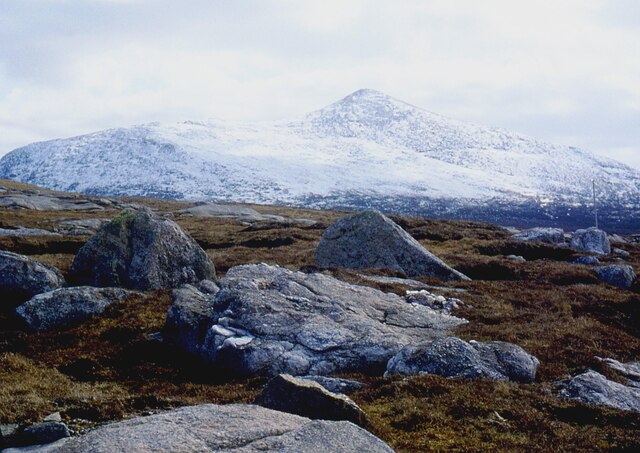
![Druim Lochan nan Learga Moorland to the south of the estate track that leads to Loch Reonasgail. This view southwards takes in the hill of Brinneabhal [213m in sunshine], with the northern spur of Mealaisbhal [Mula mac Sgiathain, 480m] beyond.](https://s0.geograph.org.uk/geophotos/01/45/91/1459172_634a34aa.jpg)
![Estate track to Loch Reonasgail This well surfaced and graded track passes through a corner of this square for around 150m [according to the 1:25000 map]. The track leads south into wild country, passing Loch Reonasgail and eventually over the Bealach Raonasgail to reach the shore of Loch Cheann Chuisil.](https://s1.geograph.org.uk/geophotos/01/45/91/1459181_01eddca9.jpg)
Loch Brinneabhal is located at Grid Ref: NB0329 (Lat: 58.153931, Lng: -7.0494368)
Unitary Authority: Na h-Eileanan an Iar
Police Authority: Highlands and Islands
What 3 Words
///charcoal.evolves.elevates. Near Carloway, Na h-Eileanan Siar
Related Wikis

Gasker
Gasker is a small uninhabited islet in the Outer Hebrides of Scotland, 8 kilometres (4+1⁄2 nautical miles) southwest of Scarp, off the west coast of Harris...

Abhainn Dearg distillery
Abhainn Dearg distillery ( AV-in JAIRG) or Red River distillery is a Scotch whisky distillery in Uig, on the west coast of the Isle of Lewis in the Outer...

Ardroil
Ardroil (Scottish Gaelic: Eadar Dhà Fhadhail) is a village on the Isle of Lewis in the Outer Hebrides, Scotland. Ardroil is within the parish of Uig....

Uig, Lewis
Uig (Scottish Gaelic: Ùig [uːkʲ]), also known as Sgìr' Ùig, is a civil parish and community in the west of the Isle of Lewis in the Outer Hebrides, Scotland...

Stac Dhòmhnaill Chaim
Stac Dhòmnuill Chaim, or Stac Dhòmhnaill Chaim, or Stac Domhnuill Chaim, is a fortified promontory located near Mangursta (or Mangersta, Scottish Gaelic...

Timsgarry
Timsgarry (Scottish Gaelic: Tuimisgearraidh) is a village on the Isle of Lewis, in the Outer Hebrides, Scotland. Timsgarry is home to the Baile na Cille...

Brenish
Brenish (Scottish Gaelic: Brèinis) is a small village situated on the west coast of the Isle of Lewis, which is part of the Outer Hebrides of Scotland...
Camas Uig
Camas Uig (Uig Bay) is a bay on the west coast of the Isle of Lewis, in the Outer Hebrides of Scotland. The Lewis Chessmen were discovered in the dunes...
Nearby Amenities
Located within 500m of 58.153931,-7.0494368Have you been to Loch Brinneabhal?
Leave your review of Loch Brinneabhal below (or comments, questions and feedback).