Badger

Settlement in Shropshire

England

Badger

Bridleway to Beckbury, Shropshire This is the bridleway from Higford. The Seven Stars public house is about 250 metres ahead at the end of the hedged lane. Real ale! Good food!
Bridleway to Beckbury, Shropshire Credit: Roger Kidd

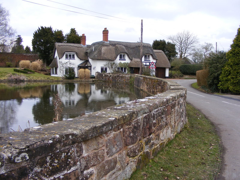
Badger is a small village located in the county of Shropshire, England. Situated about 6 miles northwest of the town of Bridgnorth, it is set amidst picturesque countryside and offers a peaceful and idyllic setting for residents and visitors alike. The village falls within the civil parish of Worfield and is part of the Shropshire Council area.

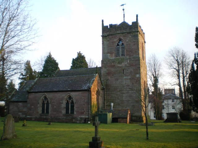
The origins of Badger can be traced back to medieval times, and it is mentioned in the Domesday Book of 1086. The village is characterized by its charming traditional architecture, with many historic buildings still standing. The centerpiece of Badger is its beautiful 12th-century church, dedicated to St. Giles, which is a Grade I listed building and serves as a focal point for the community.

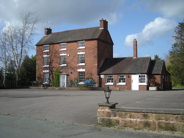
Despite its small size, Badger has a close-knit and friendly community. It offers a range of amenities to cater to the needs of its residents, including a village hall, a local pub, and a primary school. The village is surrounded by stunning natural beauty, with rolling hills, fields, and woodlands providing opportunities for outdoor activities such as walking, cycling, and horse riding.

For those seeking a taste of history and culture, Badger is conveniently located near several notable attractions. The historic market town of Bridgnorth, with its ancient castle and Severn Valley Railway, is within easy reach. Additionally, the beautiful Ironbridge Gorge, a UNESCO World Heritage site showcasing the birthplace of the Industrial Revolution, is just a short drive away.

Overall, Badger offers a charming and tranquil retreat for those looking to immerse themselves in the beauty of rural Shropshire while still being within easy reach of nearby towns and attractions.

If you have any feedback on the listing, please let us know in the comments section below.

Badger Images

Images are sourced within 2km of 52.592743/-2.34431 or Grid Reference SO7699. Thanks to Geograph Open Source API. All images are credited.

Bridleway to Beckbury, Shropshire This is the bridleway from Higford. The Seven Stars public house is about 250 metres ahead at the end of the hedged lane. Real ale! Good food!
Bridleway to Beckbury, Shropshire
This is the bridleway from Higford. The Seven Stars public house is about 250 metres ahead at the end of the hedged lane. Real ale! Good food!
Bridleway to Beckbury, Shropshire This is the bridleway (formerly) from Higford, also known as Higford Lane despite being an unsurfaced wide track. The Seven Stars public house is about five hundred metres ahead. Real ale! Good food! A footpath descends through the woodland on the left towards the River Worfe. The footpaths and bridleways in this area are very well maintained and waymarked.
Bridleway to Beckbury, Shropshire
This is the bridleway (formerly) from Higford, also known as Higford Lane despite being an unsurfaced wide track. The Seven Stars public house is about five hundred metres ahead. Real ale! Good food! A footpath descends through the woodland on the left towards the River Worfe. The footpaths and bridleways in this area are very well maintained and waymarked.
Footpath through the trees near Beckbury, Shropshire This footpath leads to another along the edge of the River Worfe floodplain. The footpaths and bridleways in this area are very well maintained and waymarked.
Footpath through the trees near Beckbury, Shropshire
This footpath leads to another along the edge of the River Worfe floodplain. The footpaths and bridleways in this area are very well maintained and waymarked.
Bridleway through farmland near Beckbury, Shropshire This is the bridleway (formerly) from Higford. It is also known as Higford Lane. The Seven Stars public house is about three hundred metres ahead. Real ale! Good food! The footpaths and bridleways in this area are very well maintained and waymarked.
Bridleway through farmland near Beckbury, Shropshire
This is the bridleway (formerly) from Higford. It is also known as Higford Lane. The Seven Stars public house is about three hundred metres ahead. Real ale! Good food! The footpaths and bridleways in this area are very well maintained and waymarked.
Bridleway to Beckbury, Shropshire This is the bridleway from Higford, with a potato field on the left. The Seven Stars public house is about three  hundred metres ahead. Real ale! Good food! The footpaths and bridleways in this area are very well maintained and waymarked.
Bridleway to Beckbury, Shropshire
This is the bridleway from Higford, with a potato field on the left. The Seven Stars public house is about three hundred metres ahead. Real ale! Good food! The footpaths and bridleways in this area are very well maintained and waymarked.
River Worfe south-west of Beckbury, Shropshire Other images of the River Worfe, which flows into the Severn north of Bridgnorth, can be seen here.
<a title="https://www.geograph.org.uk/gallery/tributaries_of_the_river_severn_7213" href="https://www.geograph.org.uk/gallery/tributaries_of_the_river_severn_7213">Link</a>
River Worfe south-west of Beckbury, Shropshire
Other images of the River Worfe, which flows into the Severn north of Bridgnorth, can be seen here. Link
Farmland near Beckbury, Shropshire The bridleway used to lead between Higford and Beckbury, by the Seven Stars public house (recommended). Potatoes grow on the left, the right being under grass, presumably for hay rather than grazing, or it would be fenced off.
Farmland near Beckbury, Shropshire
The bridleway used to lead between Higford and Beckbury, by the Seven Stars public house (recommended). Potatoes grow on the left, the right being under grass, presumably for hay rather than grazing, or it would be fenced off.
Rock outcrop south-west of Beckbury, Shropshire A public footpath from Madeley Road to Higford follows a course just above the flood plain of the River Worfe. Permo-Triassic (New Red) sandstone is extensive in the Midlands and crops out here by the river.
Rock outcrop south-west of Beckbury, Shropshire
A public footpath from Madeley Road to Higford follows a course just above the flood plain of the River Worfe. Permo-Triassic (New Red) sandstone is extensive in the Midlands and crops out here by the river.
Woodland footpath to Beckbury, Shropshire This public footpath links Higford with Madeley Road west of the Seven Stars public house in Beckbury. It leads through woodland by the River Worfe, with some raised decking by boggy areas. The footpaths and bridleways in this area are very well maintained and waymarked.
Woodland footpath to Beckbury, Shropshire
This public footpath links Higford with Madeley Road west of the Seven Stars public house in Beckbury. It leads through woodland by the River Worfe, with some raised decking by boggy areas. The footpaths and bridleways in this area are very well maintained and waymarked.
Footpath through woods to Beckbury, Shropshire This public footpath links Higford with Madeley Road west of the Seven Stars public house in Beckbury. It leads through woodland by the River Worfe, with some raised decking by boggy areas. The footpaths and bridleways in this area are very well maintained and waymarked.
Footpath through woods to Beckbury, Shropshire
This public footpath links Higford with Madeley Road west of the Seven Stars public house in Beckbury. It leads through woodland by the River Worfe, with some raised decking by boggy areas. The footpaths and bridleways in this area are very well maintained and waymarked.
River Worfe south-west of Beckbury, Shropshire The river meanders quite a bit, north of here. Access to the river banks is difficult after heavy rain, and because of undergrowth in summer. The footpath nearby is raised on decking at two points, to avoid boggy areas.
<a href="https://www.geograph.org.uk/photo/2316615">SJ7501 : Board walk by the River Worfe near Beckbury, Shropshire</a>
<a href="https://www.geograph.org.uk/photo/1781363">SJ7601 : Walkway on the footpath beside the stream, Beckbury</a>

Other images of the River Worfe, which flows into the Severn north of Bridgnorth, can be seen here.
<a title="https://www.geograph.org.uk/gallery/tributaries_of_the_river_severn_7213" href="https://www.geograph.org.uk/gallery/tributaries_of_the_river_severn_7213">Link</a>
River Worfe south-west of Beckbury, Shropshire
The river meanders quite a bit, north of here. Access to the river banks is difficult after heavy rain, and because of undergrowth in summer. The footpath nearby is raised on decking at two points, to avoid boggy areas. SJ7501 : Board walk by the River Worfe near Beckbury, Shropshire SJ7601 : Walkway on the footpath beside the stream, Beckbury Other images of the River Worfe, which flows into the Severn north of Bridgnorth, can be seen here. Link
River Worfe south-west of Beckbury, Shropshire Access to the river banks is difficult after heavy rain, and because of undergrowth in summer. The footpath nearby to the left is raised on decking at two points, to avoid boggy areas.
<a href="https://www.geograph.org.uk/photo/2316615">SJ7501 : Board walk by the River Worfe near Beckbury, Shropshire</a>
<a href="https://www.geograph.org.uk/photo/1781363">SJ7601 : Walkway on the footpath beside the stream, Beckbury</a>

Other images of the River Worfe, which flows into the Severn north of Bridgnorth, can be seen here.
<a title="https://www.geograph.org.uk/gallery/tributaries_of_the_river_severn_7213" href="https://www.geograph.org.uk/gallery/tributaries_of_the_river_severn_7213">Link</a>
River Worfe south-west of Beckbury, Shropshire
Access to the river banks is difficult after heavy rain, and because of undergrowth in summer. The footpath nearby to the left is raised on decking at two points, to avoid boggy areas. SJ7501 : Board walk by the River Worfe near Beckbury, Shropshire SJ7601 : Walkway on the footpath beside the stream, Beckbury Other images of the River Worfe, which flows into the Severn north of Bridgnorth, can be seen here. Link
Board walk by the River Worfe near Beckbury, Shropshire The riverside public footpath from Higford towards Beckbury can be particularly marshy here, so a raised board walk with rail has been provided to assist walkers. The footpaths and bridleways in this area are very well maintained and waymarked.
Board walk by the River Worfe near Beckbury, Shropshire
The riverside public footpath from Higford towards Beckbury can be particularly marshy here, so a raised board walk with rail has been provided to assist walkers. The footpaths and bridleways in this area are very well maintained and waymarked.
Woodland footpath to Beckbury, Shropshire This path from Higford towards Beckbury leads close by the River Worfe (off to the left). One section which can be boggy has two boardwalks with sturdy handrails to assist walkers. Another has something similar at the water's edge.
<a href="https://www.geograph.org.uk/photo/2316615">SJ7501 : Board walk by the River Worfe near Beckbury, Shropshire</a>
<a href="https://www.geograph.org.uk/photo/1781363">SJ7601 : Walkway on the footpath beside the stream, Beckbury</a>
The footpaths and bridleways in this area are very well maintained and waymarked.
Woodland footpath to Beckbury, Shropshire
This path from Higford towards Beckbury leads close by the River Worfe (off to the left). One section which can be boggy has two boardwalks with sturdy handrails to assist walkers. Another has something similar at the water's edge. SJ7501 : Board walk by the River Worfe near Beckbury, Shropshire SJ7601 : Walkway on the footpath beside the stream, Beckbury The footpaths and bridleways in this area are very well maintained and waymarked.
Riverside footpath to Higford, Shropshire This path from near Beckbury to Higford leads close by the River Worfe (off to the right). One section which can be boggy has two boardwalks with sturdy handrails to assist walkers. Another has something similar at the water's edge.
Riverside footpath to Higford, Shropshire
This path from near Beckbury to Higford leads close by the River Worfe (off to the right). One section which can be boggy has two boardwalks with sturdy handrails to assist walkers. Another has something similar at the water's edge.
Show me another place!

Badger is located at Grid Ref: SO7699 (Lat: 52.592743, Lng: -2.34431)

Unitary Authority: Shropshire

Police Authority: West Mercia

What 3 Words

///gifted.checked.loopholes. Near Ryton, Shropshire

Related Wikis

Badger, Shropshire

Badger is a village and civil parish in Shropshire, England, about six miles north-east of Bridgnorth. The parish had a population of 134 according to...

Ackleton

Ackleton is a village in the English county of Shropshire. It is in the civil parish of Worfield. Situated some seven miles (11 kilometers) from the market...

Beckbury

Beckbury is a village and civil parish in Shropshire, England. Beckbury had a population of 327 according to the 2001 census, increasing to 340 at the...

Burnhill Green

Burnhill Green is a small hamlet near Pattingham, situated in Staffordshire, England, in the former parish of Patshull. The hamlet is on the edge of the...

Ryton, Shropshire

Ryton is a village and civil parish in Shropshire, England, in the district of Bridgnorth. It lies about one mile north north west of Beckbury. The civil...

St Mary's Church, Patshull

St Mary's Church, Patshull, is a redundant Anglican church in the parish of Pattingham and Patshull, Staffordshire, England, and is situated near Patshull...

Caynton Caves

The Caynton Caves are a series of man-made underground chambers in the grounds of Caynton Hall, near Beckbury, Shropshire, England. Their original purpose...

A442 road

The A442 is a main road which passes through the counties of Worcestershire and Shropshire, in the West Midlands region of England. == Route == From Droitwich...

Related Videos

Shropshire Walk In Winter | Waterfall & Nature Sounds [ASMR]

Shropshire is home to many beautiful places to visit! Here I visit an outstanding icy waterfall. The sounds of nature in this video are ...

Is This Shropshire's BEST Waterfall? Exploring The Badger Dingle!

What a beautiful place! I already want to go back and explore more of The Badger Dingle! Is This Shropshire's BEST Waterfall?

Exploring Badger dingle / Shropshires little gem /canon 80d

A trip to Badger dingle..Badger is a village and civil parish in Shropshire, England, about six miles north-east of Bridgnorth.

RAF Cosford area June 23

Our circular walk was by the RAF Cosford Air Show on the day, the local area is stunning for walks! The RAF Cosford Air Show is ...

Nearby Amenities

Located within 500m of 52.592743,-2.34431
Badger
Created By: Potlatch 0.10f
Place: village
Wikidata: Q3811347
Lat/Long: 52.5922665/-2.3433539
Telephone
Defibrillator
Booth: K6
Colour: red
Defibrillator Location: inside red phone box in Badger
Emergency: defibrillator
Man Made: telephone_box
Lat/Long: 52.5921981/-2.3417093
Post Box
Post Box Type: lamp
Lat/Long: 52.592177/-2.3417066
Give Way
Direction: forward
Lat/Long: 52.592776/-2.3442646
The data included in this document is from www.openstreetmap.org. The data is made available under ODbL.

Have you been to Badger?

Leave your review of Badger below (or comments, questions and feedback).