Copwood Pool

Lake, Pool, Pond, Freshwater Marsh in Sussex Wealden

England

Copwood Pool

Owlsbury Poultry Farm
Owlsbury Poultry Farm Credit: N Chadwick

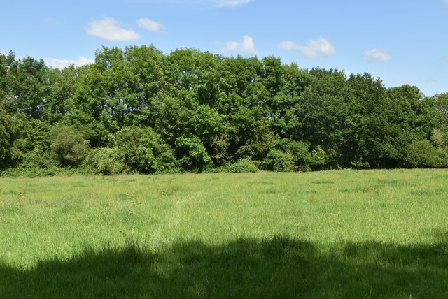
Copwood Pool is a picturesque freshwater body located in Sussex, England. Spanning across an estimated area of 5 acres, it is a serene and tranquil destination for nature enthusiasts and wildlife lovers alike. This natural water feature is often classified as a combination of a lake, pool, pond, and freshwater marsh due to its unique characteristics.

Nestled amidst lush greenery, Copwood Pool boasts crystal-clear waters that reflect the surrounding landscape, creating a stunning visual spectacle. The pool is fed by a combination of natural springs and rainfall, ensuring a constant flow of freshwater throughout the year. The water depth varies across different sections of the pool, ranging from shallow areas suitable for wading to deeper sections that attract diving birds.

The pool's ecosystem is teeming with diverse flora and fauna, making it a haven for wildlife. Water lilies, reeds, and rushes adorn the pool's edges, providing a habitat for various aquatic plant species. These plants not only enhance the pool's aesthetic appeal but also serve as a vital food source for numerous animal species.

Copwood Pool is home to an array of aquatic creatures, including fish, frogs, and newts. It also attracts a wide variety of bird species, such as ducks, herons, and kingfishers, which use the pool for feeding and nesting purposes. The surrounding marshland adds to the pool's biodiversity, attracting dragonflies, butterflies, and other insects.

With its idyllic setting and abundant wildlife, Copwood Pool offers visitors the opportunity to immerse themselves in nature's beauty. Whether it is observing the vibrant birdlife, capturing the reflections on the water's surface, or simply enjoying a peaceful stroll along the pool's edge, this natural gem in Sussex is a must-visit destination for nature enthusiasts and those seeking tranquility.

If you have any feedback on the listing, please let us know in the comments section below.

Copwood Pool Images

Images are sourced within 2km of 50.97433/0.077829537 or Grid Reference TQ4521. Thanks to Geograph Open Source API. All images are credited.

Owlsbury Poultry Farm
Owlsbury Cottages
Owlsbury Cottages
Cattle grazing
Cattle grazing
Owlsbury Cottages
Owlsbury Cottages
Owlsbury Wood
Owlsbury Wood
Owlsbury Wood
Owlsbury Wood
Footpath across field
Dismantled railway line The Wealden line ran from Tunbridge Wells to Lewes via Uckfield. The line was built in between 1846 & 1858. Most of the line has now closed to regular services. Lewes to Uckfield closed in 1969, Tunbridge Wells to Eridge closed in 1985. Eidge to Uckfield remains open as part of the Oxted line <a title="https://www.geograph.org.uk/snippet/4332" href="https://www.geograph.org.uk/snippet/4332">Link</a> . The Spa Valley Railway has re-opened the section between Tunbridge Wells West and Groombridge as a preservation line. Isfield station has been re-opened as the Lavender line.
Wikipedia: <span class="nowrap"><a title="http://en.wikipedia.org/wiki/Wealden_Line" rel="nofollow ugc noopener" href="http://en.wikipedia.org/wiki/Wealden_Line">Link</a><img style="margin-left:2px;" alt="External link" title="External link - shift click to open in new window" src="https://s1.geograph.org.uk/img/external.png" width="10" height="10"/></span>
Dismantled railway line
The Wealden line ran from Tunbridge Wells to Lewes via Uckfield. The line was built in between 1846 & 1858. Most of the line has now closed to regular services. Lewes to Uckfield closed in 1969, Tunbridge Wells to Eridge closed in 1985. Eidge to Uckfield remains open as part of the Oxted line Link . The Spa Valley Railway has re-opened the section between Tunbridge Wells West and Groombridge as a preservation line. Isfield station has been re-opened as the Lavender line. Wikipedia: LinkExternal link
Owlsbury Farm
Owlsbury Farm
Dismantled railway line The Wealden line ran from Tunbridge Wells to Lewes via Uckfield. The line was built in between 1846 & 1858. Most of the line has now closed to regular services. Lewes to Uckfield closed in 1969, Tunbridge Wells to Eridge closed in 1985. Eidge to Uckfield remains open as part of the Oxted line <a title="https://www.geograph.org.uk/snippet/4332" href="https://www.geograph.org.uk/snippet/4332">Link</a> . The Spa Valley Railway has re-opened the section between Tunbridge Wells West and Groombridge as a preservation line. Isfield station has been re-opened as the Lavender line.
Wikipedia: <span class="nowrap"><a title="http://en.wikipedia.org/wiki/Wealden_Line" rel="nofollow ugc noopener" href="http://en.wikipedia.org/wiki/Wealden_Line">Link</a><img style="margin-left:2px;" alt="External link" title="External link - shift click to open in new window" src="https://s1.geograph.org.uk/img/external.png" width="10" height="10"/></span>
Dismantled railway line
The Wealden line ran from Tunbridge Wells to Lewes via Uckfield. The line was built in between 1846 & 1858. Most of the line has now closed to regular services. Lewes to Uckfield closed in 1969, Tunbridge Wells to Eridge closed in 1985. Eidge to Uckfield remains open as part of the Oxted line Link . The Spa Valley Railway has re-opened the section between Tunbridge Wells West and Groombridge as a preservation line. Isfield station has been re-opened as the Lavender line. Wikipedia: LinkExternal link
Field by the A22, Uckfield
The A22, Uckfield
The A22, Uckfield
Former Signal Box at Uckfield, Sussex Formerly a significant intermediate station on the London- Lewes branch line (via Oxted). The route now terminates at Uckfield; with the new station out of picture, to the right. A taxi company is now based in this building.
Former Signal Box at Uckfield, Sussex
Formerly a significant intermediate station on the London- Lewes branch line (via Oxted). The route now terminates at Uckfield; with the new station out of picture, to the right. A taxi company is now based in this building.
Train at Uckfield Station, Sussex The end of the line; which runs to London, via Oxted. Whilst many trains run through to London; this one was shortly to depart, for Oxted, to connect with a service from East Grinstead.
Train at Uckfield Station, Sussex
The end of the line; which runs to London, via Oxted. Whilst many trains run through to London; this one was shortly to depart, for Oxted, to connect with a service from East Grinstead.
Sculpture at Uckfield, Sussex Sculpture of a Town Crier, located close to the bridge over the River Uck.
Sculpture at Uckfield, Sussex
Sculpture of a Town Crier, located close to the bridge over the River Uck.
Morris 1000 Traveller, Uckfield, Sussex A fine survivor, some 45 years old.
Morris 1000 Traveller, Uckfield, Sussex
A fine survivor, some 45 years old.
Morris 1000 Traveller, Uckfield, Sussex At some stage in its 45 year life, some of the timbers have been replaced on the car. Timber rot was always a problem with this model, especially if left out in all weathers.
Morris 1000 Traveller, Uckfield, Sussex
At some stage in its 45 year life, some of the timbers have been replaced on the car. Timber rot was always a problem with this model, especially if left out in all weathers.
Show me another place!

Copwood Pool is located at Grid Ref: TQ4521 (Lat: 50.97433, Lng: 0.077829537)

Administrative County: East Sussex

District: Wealden

Police Authority: Sussex

What 3 Words

///courts.rejoined.sliders. Near Uckfield, East Sussex

Related Wikis

West Park, Uckfield

West Park is a 10.5-hectare (26-acre) Local Nature Reserve on the western outskirts of Uckfield in East Sussex. It is owned and managed by Uckfield Town...

Copping Hall

Copping Hall is a Grade II* listed house in Uckfield, East Sussex, England. It is located at 1 Pudding Cake Lane, Uckfield, East Sussex TN22 1BT. Built...

Uckfield railway station

Uckfield railway station is the southern terminus of a branch of the Oxted Line in England, serving the town of Uckfield, East Sussex. It is 46 miles 8...

Uckfield Town F.C.

Uckfield Town F.C. was a football club based in Uckfield, East Sussex, England. For their final season, 2013–14, they were members of the Sussex County...

Uckfield Baptist Church

Uckfield Baptist Church is a Baptist congregation based in the town of Uckfield in East Sussex, England. Although services now take place in a school...

Hempstead Meadow

Hempstead Meadow is a 1.6-hectare (4.0-acre) Local Nature Reserve in Uckfield in East Sussex. It is owned and managed by Uckfield Town Council.The site...

Uckfield

Uckfield () is a town in the Wealden District of East Sussex in South East England. The town is on the River Uck, one of the tributaries of the River Ouse...

Uckfield College

Uckfield College (formerly Uckfield Community Technology College) is a community college situated in Uckfield, UK. It has approximately 1,720 students...

Nearby Amenities

Located within 500m of 50.97433,0.077829537
West Park
Place: locality
Lat/Long: 50.9717062/0.082757
Barrier: stile
Lat/Long: 50.9754462/0.0827353
Copwood Farm
Place: farm
Source Name: OS_OpenData_Streetview
Lat/Long: 50.9705287/0.0788164
Batchelor Way
Power: substation
Lat/Long: 50.9718147/0.0829217
Calvert Road
Power: substation
Lat/Long: 50.9738858/0.0842954
Barrier: kissing_gate
Lat/Long: 50.9751283/0.0802767
Addr City: Uckfield
Addr Housename: Old Copwood
Addr Postcode: TN22 3PT
Addr Street: Rocks Road
Building: house
Fhrs Id: 164358
Source: OS_OpenData_StreetView
Source Addr: FDRS Open Data
Lat/Long: 50.9715246/0.0763196
Barrier: kissing_gate
Lat/Long: 50.975252/0.0814478
Barrier: kissing_gate
Lat/Long: 50.975028/0.0802632
Footpath
Information: guidepost
Operator: East Sussex County Council
Tourism: information
Lat/Long: 50.9750178/0.0795319
Barrier: stile
Lat/Long: 50.9749965/0.0794925
Tourism: viewpoint
Lat/Long: 50.9756778/0.082512
Barrier: wall
Lat/Long: 50.9751476/0.0809978
Generator Method: photovoltaic
Generator Orientation: 180
Generator Output Electricity: yes
Generator Solar Modules: 16
Generator Source: solar
Generator Type: solar_photovoltaic_panel
Location: roof
Power: generator
Lat/Long: 50.9728061/0.0836153
Generator Method: photovoltaic
Generator Orientation: 220
Generator Output Electricity: yes
Generator Solar Modules: 16
Generator Source: solar
Generator Type: solar_photovoltaic_panel
Location: roof
Power: generator
Lat/Long: 50.9733758/0.0842398
Generator Method: photovoltaic
Generator Orientation: 215
Generator Output Electricity: yes
Generator Solar Modules: 10
Generator Source: solar
Generator Type: solar_photovoltaic_panel
Location: roof
Power: generator
Lat/Long: 50.9745576/0.0840618
Generator Method: photovoltaic
Generator Orientation: 210
Generator Output Electricity: yes
Generator Solar Modules: 10
Generator Source: solar
Generator Type: solar_photovoltaic_panel
Location: roof
Power: generator
Lat/Long: 50.9743398/0.0838378
Generator Method: photovoltaic
Generator Orientation: 120
Generator Output Electricity: yes
Generator Solar Modules: 16
Generator Source: solar
Generator Type: solar_photovoltaic_panel
Location: roof
Power: generator
Lat/Long: 50.9741709/0.0833818
Generator Method: photovoltaic
Generator Orientation: 140
Generator Output Electricity: yes
Generator Solar Modules: 16
Generator Source: solar
Generator Type: solar_photovoltaic_panel
Location: roof
Power: generator
Lat/Long: 50.9734379/0.083878
Generator Method: photovoltaic
Generator Orientation: 140
Generator Output Electricity: yes
Generator Solar Modules: 16
Generator Source: solar
Generator Type: solar_photovoltaic_panel
Location: roof
Power: generator
Lat/Long: 50.973551/0.0840443
Generator Method: photovoltaic
Generator Orientation: 180
Generator Output Electricity: yes
Generator Source: solar
Generator Type: solar_photovoltaic_panel
Location: roof
Power: generator
Lat/Long: 50.9725022/0.0827958
Footpath
Information: guidepost
Operator: East Sussex County Council
Tourism: information
Lat/Long: 50.9777379/0.0767144
Footpath
Information: guidepost
Operator: East Sussex County Council
Tourism: information
Lat/Long: 50.9776021/0.0769998
Footpath
Information: guidepost
Operator: East Sussex County Council
Tourism: information
Lat/Long: 50.9762706/0.0790212
Public Footpath
Information: guidepost
Tourism: information
Lat/Long: 50.9758085/0.0798816
Ford: yes
Lat/Long: 50.9722603/0.0812568
The data included in this document is from www.openstreetmap.org. The data is made available under ODbL.

Have you been to Copwood Pool?

Leave your review of Copwood Pool below (or comments, questions and feedback).