Aber-nant

Settlement in Denbighshire

Wales

Aber-nant

Moored narrowboats on the Llangollen Canal Several boats are moored here, presumably for the local amenities; pubs, shops etc.
Moored narrowboats on the Llangollen Canal Credit: Jeremy Bolwell

Aber-nant is a small village located in the county of Denbighshire, Wales. Situated in the picturesque Vale of Clwyd, it lies approximately 5 miles southwest of the market town of Ruthin and 15 miles southeast of the coastal town of Rhyl. With a population of around 500 residents, Aber-nant offers a tranquil and close-knit community atmosphere.

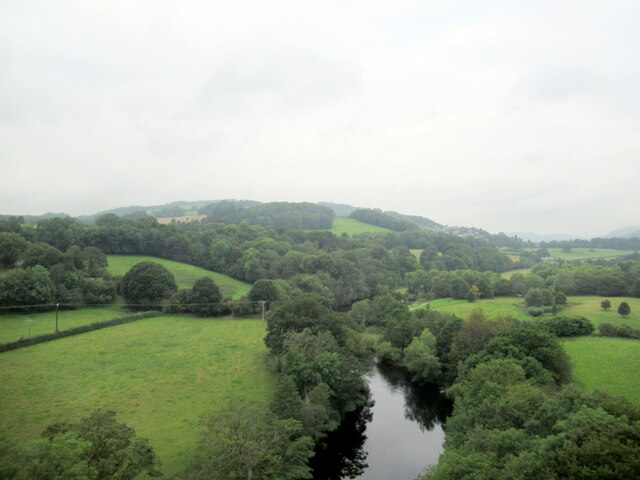
The village is surrounded by rolling hills and lush green countryside, providing stunning views and ample opportunities for outdoor activities such as hiking, cycling, and horse riding. The River Clwyd flows nearby, adding to the natural beauty of the area.

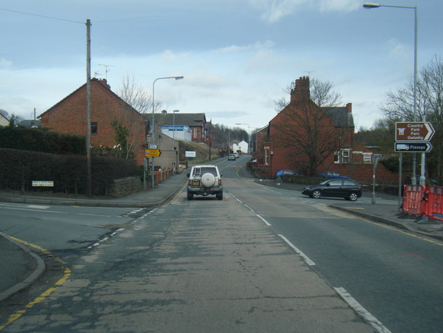
Aber-nant is well-connected with neighboring towns and villages through a network of roads, making it easily accessible for both residents and visitors. The village itself has a community center, a primary school, a local pub, and a few small shops catering to daily needs.

Historically, Aber-nant had a strong agricultural presence, with farming playing a significant role in the local economy. While agriculture is still important, the village has seen an increase in diversification, with some residents now working in nearby towns or commuting to larger cities for employment.

Overall, Aber-nant offers a peaceful retreat from the hustle and bustle of city life. Its natural beauty, close community ties, and convenient location make it an attractive place to live or visit for those seeking a tranquil Welsh countryside experience.

If you have any feedback on the listing, please let us know in the comments section below.

Aber-nant Images

Images are sourced within 2km of 52.978126/-3.079381 or Grid Reference SJ2742. Thanks to Geograph Open Source API. All images are credited.

Moored narrowboats on the Llangollen Canal Several boats are moored here, presumably for the local amenities; pubs, shops etc.
Moored narrowboats on the Llangollen Canal
Several boats are moored here, presumably for the local amenities; pubs, shops etc.
Yard beside the Llangollen Canal A haulage yard? It has a collection of lorries. A tractor yard? It has a collection of tractors. An interesting number of questions are prompted.
Yard beside the Llangollen Canal
A haulage yard? It has a collection of lorries. A tractor yard? It has a collection of tractors. An interesting number of questions are prompted.
View from the Llangollen Canal to a little hilltop Cefn Bychan I presume.
View from the Llangollen Canal to a little hilltop
Cefn Bychan I presume.
Houses backing on to the Llangollen Canal at Froncysyllte A lovely variety of gardens back onto the canal here, many with tiered levels, a testimony to the hard work of residents over the years.
Houses backing on to the Llangollen Canal at Froncysyllte
A lovely variety of gardens back onto the canal here, many with tiered levels, a testimony to the hard work of residents over the years.
Beside the Llangollen Canal at Froncysyllte An immensely pleasurable place to stroll on a hot July afternoon.
Beside the Llangollen Canal at Froncysyllte
An immensely pleasurable place to stroll on a hot July afternoon.
Canoeists on the Llangollen Canal at Froncysyllte The canal is busy with newly launched paddlers. No one fell in.
Canoeists on the Llangollen Canal at Froncysyllte
The canal is busy with newly launched paddlers. No one fell in.
Scene on part of the Llangollen Canal just south of Froncysyllte Aqueduct Traders ply their wares from a few narrowboats moored here; a coffee shop, a woodcarver, a metalworker and ice cream etc - an ideal mix.
Scene on part of the Llangollen Canal just south of Froncysyllte Aqueduct
Traders ply their wares from a few narrowboats moored here; a coffee shop, a woodcarver, a metalworker and ice cream etc - an ideal mix.
Scene on the Froncysyllte Aqueduct in July Always a thrill to stroll across.
Scene on the Froncysyllte Aqueduct in July
Always a thrill to stroll across.
Narrowboat on the Froncysyllte Aqueduct in July This chap is chugging along with elan. His daughter or grand-daughter is clamouring for him to look at something that has caught her attention some 200 feet below and he advises her that he cannot divert his attention, even for a second, away from steering, somewhat to my own amusement as I stroll alongside. I'm 100% with him. It is hard to stroll along on the towing path. I cannot imagine floating across suspended on water in a lead tank at this height, depending on two centuries old engineering. Cap doffed sir!
Narrowboat on the Froncysyllte Aqueduct in July
This chap is chugging along with elan. His daughter or grand-daughter is clamouring for him to look at something that has caught her attention some 200 feet below and he advises her that he cannot divert his attention, even for a second, away from steering, somewhat to my own amusement as I stroll alongside. I'm 100% with him. It is hard to stroll along on the towing path. I cannot imagine floating across suspended on water in a lead tank at this height, depending on two centuries old engineering. Cap doffed sir!
A busy scene on the Llangollen Canal Cyclists, dog walkers and their canine charges, walkers and gongoozlers all mix here in a melee of sights and sounds, colour and movement.
A busy scene on the Llangollen Canal
Cyclists, dog walkers and their canine charges, walkers and gongoozlers all mix here in a melee of sights and sounds, colour and movement.
Canoe on the Llangollen Canal near Trevor I am interested in watching the canoe and tempted to pay the pub up ahead a visit.
Canoe on the Llangollen Canal near Trevor
I am interested in watching the canoe and tempted to pay the pub up ahead a visit.
On Froncysyllte Aqueduct What a piece of work this structure is!

It is all too easy to be unaware, or even to forget, as I had done, that this aqueduct, along with the railway bridge and canal aqueduct at nearby Chirk comprises a World Heritage Site.

Wikipedia explanation <span class="nowrap"><a title="https://en.wikipedia.org/wiki/World_Heritage_Site" rel="nofollow ugc noopener" href="https://en.wikipedia.org/wiki/World_Heritage_Site">Link</a><img style="margin-left:2px;" alt="External link" title="External link - shift click to open in new window" src="https://s1.geograph.org.uk/img/external.png" width="10" height="10"/></span> here.
On Froncysyllte Aqueduct
What a piece of work this structure is! It is all too easy to be unaware, or even to forget, as I had done, that this aqueduct, along with the railway bridge and canal aqueduct at nearby Chirk comprises a World Heritage Site. Wikipedia explanation LinkExternal link here.
On Froncysyllte Aqueduct This chap is coolly navigating his way across this amazing structure, making a quip as he notices me taking his photo. He seems the seasoned professional and looks like he has passed this way more than once. Lucky man. I envy his poise, his mode of transport and the day he is having, while I am footslogging in the heat..
On Froncysyllte Aqueduct
This chap is coolly navigating his way across this amazing structure, making a quip as he notices me taking his photo. He seems the seasoned professional and looks like he has passed this way more than once. Lucky man. I envy his poise, his mode of transport and the day he is having, while I am footslogging in the heat..
On Froncysyllte Aqueduct A narrowboat packed with day-trippers prepares to pass across the amazing structure. It lists because they are all cramming to take photos and look out of the port side. That's the left to landlubbers!
On Froncysyllte Aqueduct
A narrowboat packed with day-trippers prepares to pass across the amazing structure. It lists because they are all cramming to take photos and look out of the port side. That's the left to landlubbers!
Old shop beside the A5 road in Froncysyllte It looks like it was a small shop in the past, then a booking office for a luxury car company.
Old shop beside the A5 road in Froncysyllte
It looks like it was a small shop in the past, then a booking office for a luxury car company.
Paddock below the A5 road The two residents seem to be avoiding the flies here together.
Paddock below the A5 road
The two residents seem to be avoiding the flies here together.
Froncysyllte Aqueduct Exhilarating view along side of aqueduct
Froncysyllte Aqueduct
Exhilarating view along side of aqueduct
The River Dee from the Newbridge viaduct
Show me another place!

Aber-nant is located at Grid Ref: SJ2742 (Lat: 52.978126, Lng: -3.079381)

Unitary Authority: Denbighshire

Police Authority: North Wales

Also known as: Abernant

What 3 Words

///swelling.beep.raft. Near Ruabon, Wrexham

Related Wikis

Acrefair

Acrefair (Welsh: Acre-fair; [ˌakrɛˈvɑɪr] ) is a village in Wrexham County Borough, north-east Wales, in the community of Cefn. It was formerly part of...

Acrefair railway station

Acrefair railway station (Welsh pronunciation: [ˌakrɛˈvɑɪr] ak-REH-vire) was a former station on the Ruabon–Barmouth line in North East Wales. It closed...

Cefn Mawr

Cefn Mawr (Welsh: Cefn-mawr; ) is a village in the community of Cefn within Wrexham County Borough, Wales. Its name translates as "big ridge". The population...

The Rock, Rhosymedre

The Rock is a football stadium based in Rhosymedre, Wales. It is currently the home stadium for Cymru North teams Cefn Druids and Gresford Athletic FC...

Rhosymedre

Rhosymedre () is a village within the community of Cefn, in Wrexham County Borough, Wales. The Anglican church, which was consecrated in 1837, is dedicated...

Ruabon Brook Tramway

The Ruabon Brook Tramway (also known as Jessop's Tramway, and in its later years as the Shropshire Union Tramway) was a Welsh horse-drawn tramway linking...

Trevor, Wrexham

Trevor (Welsh: Trefor) is a village in Wrexham County Borough, Wales. It is situated in the scenic Vale of Llangollen, on the A539 between Llangollen and...

Trevor Basin

Trevor Basin is a canal basin on the Llangollen Canal, situated near Trevor, Wrexham County Borough, Wales, in between Llangollen and Ruabon. The basin...

Nearby Amenities

Located within 500m of 52.978126,-3.079381
Grit Bin
Lat/Long: 52.979943/-3.078978
Grit Bin
Lat/Long: 52.978131/-3.08539
Street Lamp
Ref: none
Source Ref: survey
Lat/Long: 52.9749016/-3.0744001
Addr Housename: the Grosvenor
Addr Housenumber: 88
Source Addr Housenumber: survey
Lat/Long: 52.9751172/-3.0744631
Street Lamp
Ref: 183
Source Ref: survey
Lat/Long: 52.9759063/-3.0744236
Grit Bin
Access: yes
Ref: T03
Source: survey
Lat/Long: 52.9760369/-3.0743246
Street Lamp
Ref: none
Source Ref: survey
Lat/Long: 52.9763587/-3.0740555
Grit Bin
Access: yes
Ref: t10
Source Ref: survey
Lat/Long: 52.9765931/-3.0737343
Street Lamp
Ref: none
Source Ref: survey
Lat/Long: 52.9767503/-3.0737611
Street Lamp
Ref: none
Source Ref: survey
Lat/Long: 52.9755602/-3.0740645
Grit Bin
Access: yes
Ref: T04
Source Ref: survey
Lat/Long: 52.975401/-3.0741539
Street Lamp
Ref: 219
Source Ref: survey
Lat/Long: 52.9753037/-3.073969
Street Lamp
Ref: 220
Source Ref: survey
Lat/Long: 52.9752273/-3.0738108
Street Lamp
Ref: none
Source: survey
Lat/Long: 52.9756125/-3.0734082
Street Lamp
Note: new lamp adjacent to old
Ref: none
Source: survey
Lat/Long: 52.9770844/-3.0730762
Pub
Eagles Inn
Wikidata: Q80855830
Lat/Long: 52.9802536/-3.076096
Acrefair
Abandoned Railway: station
Railway: site
Wikidata: Q4675081
Wikipedia: en:Acrefair railway station
Lat/Long: 52.9794256/-3.0740122
Acrefair
Alt Name: Acre-fair
Alt Name Cy: Acre-fair
Alt Name En: Acre-fair
Name Cy: Acrefair
Name En: Acrefair
Place: village
Wikidata: Q4675083
Wikipedia: en:Acrefair
Lat/Long: 52.9804898/-3.0804834
Direction: SSE
Generator Method: photovoltaic
Generator Output Electricity: yes
Generator Solar Modules: 2
Generator Source: solar
Generator Type: solar_photovoltaic_panel
Location: roof
Power: generator
Lat/Long: 52.9795698/-3.0767325
Direction: SSE
Generator Method: photovoltaic
Generator Output Electricity: yes
Generator Solar Modules: 2
Generator Source: solar
Generator Type: solar_photovoltaic_panel
Location: roof
Power: generator
Lat/Long: 52.9795488/-3.0768344
Direction: WSW
Generator Method: photovoltaic
Generator Output Electricity: yes
Generator Solar Modules: 3
Generator Source: solar
Generator Type: solar_photovoltaic_panel
Location: roof
Power: generator
Lat/Long: 52.9794292/-3.0771281
Direction: WSW
Generator Method: photovoltaic
Generator Output Electricity: yes
Generator Solar Modules: 3
Generator Source: solar
Generator Type: solar_photovoltaic_panel
Location: roof
Power: generator
Lat/Long: 52.9795301/-3.0771965
Direction: WSW
Generator Method: photovoltaic
Generator Output Electricity: yes
Generator Solar Modules: 3
Generator Source: solar
Generator Type: solar_photovoltaic_panel
Location: roof
Power: generator
Lat/Long: 52.9796165/-3.0772649
Direction: SSE
Generator Method: photovoltaic
Generator Output Electricity: yes
Generator Solar Modules: 11
Generator Source: solar
Generator Type: solar_photovoltaic_panel
Location: roof
Power: generator
Source: survey
Lat/Long: 52.9800437/-3.0775183
Direction: WSW
Generator Method: photovoltaic
Generator Output Electricity: yes
Generator Solar Modules: 10
Generator Source: solar
Generator Type: solar_photovoltaic_panel
Location: roof
Power: generator
Lat/Long: 52.9802177/-3.0776799
Direction: SSW
Generator Method: photovoltaic
Generator Output Electricity: yes
Generator Solar Modules: 8
Generator Source: solar
Generator Type: solar_photovoltaic_panel
Location: roof
Power: generator
Lat/Long: 52.9823054/-3.0799397
Direction: 195
Generator Method: photovoltaic
Generator Output Electricity: yes
Generator Solar Modules: 17
Generator Source: solar
Generator Type: solar_photovoltaic_panel
Location: roof
Power: generator
Lat/Long: 52.9821267/-3.0793262
Direction: SSE
Generator Method: photovoltaic
Generator Output Electricity: yes
Generator Solar Modules: 16
Generator Source: solar
Generator Type: solar_photovoltaic_panel
Location: roof
Power: generator
Lat/Long: 52.9819965/-3.0787844
Direction: 175
Generator Method: photovoltaic
Generator Output Electricity: yes
Generator Solar Modules: 16
Generator Source: solar
Generator Type: solar_photovoltaic_panel
Location: roof
Power: generator
Lat/Long: 52.9820494/-3.0777383
Barrier: height_restrictor
Maxheight: 2.2
Maxheight Imperial: 7'2"
Source: survey
Lat/Long: 52.9803339/-3.0769685
Post Box
Operator: Royal Mail
Operator Type: private
Operator Wikidata: Q638098
Post Box Type: lamp
Royal Cypher: EIIR
Royal Cypher Wikidata: Q33102113
Lat/Long: 52.9802353/-3.0767999
Direction: SSE
Generator Method: photovoltaic
Generator Output Electricity: yes
Generator Solar Modules: 12
Generator Source: solar
Generator Type: solar_photovoltaic_panel
Location: roof
Power: generator
Lat/Long: 52.9793082/-3.0759943
Direction: S
Generator Method: photovoltaic
Generator Output Electricity: yes
Generator Solar Modules: 15
Generator Source: solar
Generator Type: solar_photovoltaic_panel
Location: roof
Power: generator
Source: Maxar Premium Imagery
Lat/Long: 52.9789757/-3.0823433
Direction: 145
Generator Method: photovoltaic
Generator Output Electricity: yes
Generator Solar Modules: 10
Generator Source: solar
Generator Type: solar_photovoltaic_panel
Location: roof
Power: generator
Source: Maxar Premium Imagery
Lat/Long: 52.9802624/-3.0855874
Trefynant Junction
Railway: junction
Lat/Long: 52.9764431/-3.0838945
Direction: 175
Generator Method: photovoltaic
Generator Output Electricity: yes
Generator Solar Modules: 4
Generator Source: solar
Generator Type: solar_photovoltaic_panel
Location: roof
Power: generator
Lat/Long: 52.9820393/-3.0778905
Direction: 175
Generator Method: photovoltaic
Generator Output Electricity: yes
Generator Solar Modules: 4
Generator Source: solar
Generator Type: solar_photovoltaic_panel
Location: roof
Power: generator
Lat/Long: 52.9820357/-3.0779663
Direction: ESE
Generator Method: photovoltaic
Generator Output Electricity: yes
Generator Solar Modules: 11
Generator Source: solar
Generator Type: solar_photovoltaic_panel
Location: roof
Power: generator
Lat/Long: 52.9824443/-3.080568
Direction: SSW
Generator Method: photovoltaic
Generator Output Electricity: yes
Generator Solar Modules: 4
Generator Source: solar
Generator Type: solar_photovoltaic_panel
Location: roof
Power: generator
Lat/Long: 52.9824685/-3.0804996
The data included in this document is from www.openstreetmap.org. The data is made available under ODbL.

Have you been to Aber-nant?

Leave your review of Aber-nant below (or comments, questions and feedback).