Abernant

Settlement in Carmarthenshire

Wales

Abernant

Pontdroed Felin Newydd  / Felin Newydd footbridge Pontdroed yn rhychwantu nant ddi-enw gerllaw'r Felin Newydd (jyst mewn golwg yn y pellter). Mae'r nant hefyd yn ffinio dau blwyf, sef Abernant a Llannewydd. Noder y rhyd. Mae'r hen heol yn dringo'r bryn i gyfeiriad Ffarm Shidenyn a phan roedd y felin yn ei hanterth gwelid, yn sicr, lawer o fynd a dod arni. Heddiw, ambell gerddwr sydd yn ei defnyddio. 

A footbridge spanning an unnamed stream near Felin Newydd (trans. New Mill), just visible in the distance. The stream also acts an administrative boundary for two parishes, Abernant and Newchurch. Note the ford. The road leads up the hill in the direction of Shidenyn Farm. Without doubt, when the mill was working the old road would have seen much coming and going. Today, only the occasional walker uses it.
Pontdroed Felin Newydd / Felin Newydd footbridge Credit: Alan Richards

Abernant is a small village located in the county of Carmarthenshire, Wales. Situated in the picturesque Tywi Valley, it is surrounded by rolling hills and lush green fields. The village lies about 7 miles north of the county town of Carmarthen, making it easily accessible for both residents and visitors.

Historically, Abernant was primarily an agricultural community, with farming being the main occupation for its inhabitants. Today, however, the village has evolved into a more residential area, with a mix of traditional cottages and modern houses. The population of Abernant is relatively small, creating a close-knit community atmosphere.

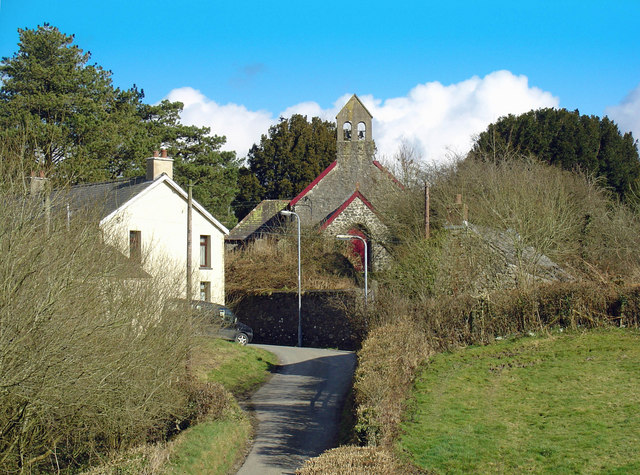
Despite its small size, Abernant offers a range of amenities for its residents. These include a local primary school, a community hall, and a village pub. The village is also known for its beautiful church, St. Mary's, which dates back to the 13th century and is a popular destination for history enthusiasts.

For those seeking outdoor activities, Abernant is surrounded by stunning natural landscapes. The nearby Tywi Forest provides ample opportunities for hiking, cycling, and wildlife spotting. The village is also conveniently located near the Brecon Beacons National Park, renowned for its breathtaking scenery and outdoor pursuits.

In conclusion, Abernant is a charming village nestled in the heart of Carmarthenshire. Its idyllic setting, sense of community, and proximity to both rural and urban amenities make it an attractive place to live or visit for those seeking a peaceful and picturesque Welsh countryside experience.

If you have any feedback on the listing, please let us know in the comments section below.

Abernant Images

Images are sourced within 2km of 51.882649/-4.412658 or Grid Reference SN3423. Thanks to Geograph Open Source API. All images are credited.

Pontdroed Felin Newydd  / Felin Newydd footbridge Pontdroed yn rhychwantu nant ddi-enw gerllaw'r Felin Newydd (jyst mewn golwg yn y pellter). Mae'r nant hefyd yn ffinio dau blwyf, sef Abernant a Llannewydd. Noder y rhyd. Mae'r hen heol yn dringo'r bryn i gyfeiriad Ffarm Shidenyn a phan roedd y felin yn ei hanterth gwelid, yn sicr, lawer o fynd a dod arni. Heddiw, ambell gerddwr sydd yn ei defnyddio. 

A footbridge spanning an unnamed stream near Felin Newydd (trans. New Mill), just visible in the distance. The stream also acts an administrative boundary for two parishes, Abernant and Newchurch. Note the ford. The road leads up the hill in the direction of Shidenyn Farm. Without doubt, when the mill was working the old road would have seen much coming and going. Today, only the occasional walker uses it.
Pontdroed Felin Newydd / Felin Newydd footbridge
Pontdroed yn rhychwantu nant ddi-enw gerllaw'r Felin Newydd (jyst mewn golwg yn y pellter). Mae'r nant hefyd yn ffinio dau blwyf, sef Abernant a Llannewydd. Noder y rhyd. Mae'r hen heol yn dringo'r bryn i gyfeiriad Ffarm Shidenyn a phan roedd y felin yn ei hanterth gwelid, yn sicr, lawer o fynd a dod arni. Heddiw, ambell gerddwr sydd yn ei defnyddio. A footbridge spanning an unnamed stream near Felin Newydd (trans. New Mill), just visible in the distance. The stream also acts an administrative boundary for two parishes, Abernant and Newchurch. Note the ford. The road leads up the hill in the direction of Shidenyn Farm. Without doubt, when the mill was working the old road would have seen much coming and going. Today, only the occasional walker uses it.
Abernant C.P. School Some very crude photoshopping to bring up the school while preserving the sunset
Abernant C.P. School
Some very crude photoshopping to bring up the school while preserving the sunset
Llwybr Posty Uchaf  / Posty Uchaf Path Hen gât fochyn ar lwybr cyhoeddus ger Ffarm Posty Uchaf sy wedi'i hen esgeuluso'n gan y cyngor cymunedol lleol a'r cyngor sir sy'n gyndyn iawn i'w ailagor. 

Old kissing gate on a long neglected path leading to Posty Uchaf Farm. Despite complaining to the local community council and county council nothing seems to get done!
Llwybr Posty Uchaf / Posty Uchaf Path
Hen gât fochyn ar lwybr cyhoeddus ger Ffarm Posty Uchaf sy wedi'i hen esgeuluso'n gan y cyngor cymunedol lleol a'r cyngor sir sy'n gyndyn iawn i'w ailagor. Old kissing gate on a long neglected path leading to Posty Uchaf Farm. Despite complaining to the local community council and county council nothing seems to get done!
Llwybr Pantycendy Hall  / Pantycendy path Gât fochyn ar lwybr cyhoeddus sy'n mynd heibio i Neuadd Pantycendy.

Kissing gate on a path that goes past Pantycendy Hall (poss. from Pantycefndu  i.e. black ridge hollow?)
Llwybr Pantycendy Hall / Pantycendy path
Gât fochyn ar lwybr cyhoeddus sy'n mynd heibio i Neuadd Pantycendy. Kissing gate on a path that goes past Pantycendy Hall (poss. from Pantycefndu i.e. black ridge hollow?)
Llwybr Felin Newydd  / Felin Newydd path Gatiau a gwifren bigog yn rhwystro'r llwybr cyhoeddus uwchlaw'r Felin Newydd. 

Gates and barbed wire obstruct a public footpath above Felin Newydd (trans. new mill).
Llwybr Felin Newydd / Felin Newydd path
Gatiau a gwifren bigog yn rhwystro'r llwybr cyhoeddus uwchlaw'r Felin Newydd. Gates and barbed wire obstruct a public footpath above Felin Newydd (trans. new mill).
Eglwys Abernant  / Abernant Church Eglwys Santes Lucia yn Abernant (Aberneint gynt). 

St Lucia Church at Abernant, formerly Aberneint (trans. confluence of the streams)
Eglwys Abernant / Abernant Church
Eglwys Santes Lucia yn Abernant (Aberneint gynt). St Lucia Church at Abernant, formerly Aberneint (trans. confluence of the streams)
Ordnance Survey Cut Mark This OS cut mark can be found on the east parapet of Aberhenllan Bridge. It marks a point 40.408m above mean sea level.
Ordnance Survey Cut Mark
This OS cut mark can be found on the east parapet of Aberhenllan Bridge. It marks a point 40.408m above mean sea level.
Ordnance Survey Cut Mark This OS cut mark can be found on the church hall. It marks a point 92.631m above mean sea level.
Ordnance Survey Cut Mark
This OS cut mark can be found on the church hall. It marks a point 92.631m above mean sea level.
Ordnance Survey Cut Mark This OS cut mark can be found on the gatepost of the chapel. It marks a point 132.692m above mean sea level.
Ordnance Survey Cut Mark
This OS cut mark can be found on the gatepost of the chapel. It marks a point 132.692m above mean sea level.
Ordnance Survey Cut Mark This OS cut mark can be found on the barn at Blaenant Farm. It marks a point 128.827m above mean sea level.
Ordnance Survey Cut Mark
This OS cut mark can be found on the barn at Blaenant Farm. It marks a point 128.827m above mean sea level.
Ford below Penygaer Farm This ford is found at Felin Newydd at the start of the now blocked byway leading up to Shidenyn Farm.
The next farm upstream is Pen Y Gaer Farm which featured in the BBC film Borrowed Pasture which  featured two Polish soldiers trying to make a living on the farm and was narrated by Richard Burton.
Ford below Penygaer Farm
This ford is found at Felin Newydd at the start of the now blocked byway leading up to Shidenyn Farm. The next farm upstream is Pen Y Gaer Farm which featured in the BBC film Borrowed Pasture which featured two Polish soldiers trying to make a living on the farm and was narrated by Richard Burton.
Church of St Lucia, Abernant Mainly a medieval church, restored in 1899 when the porch was added and the double bellcote rebuilt.  The church is in a huge churchyard, which also serves several surrounding parishes. There is plenty of space left.

(Information from 'The Buildings of Wales')
Church of St Lucia, Abernant
Mainly a medieval church, restored in 1899 when the porch was added and the double bellcote rebuilt. The church is in a huge churchyard, which also serves several surrounding parishes. There is plenty of space left. (Information from 'The Buildings of Wales')
The road through Abernant Abernant is a very small village, but does have a school further up the road on the left.
The road through Abernant
Abernant is a very small village, but does have a school further up the road on the left.
Ordnance Survey Cut Mark This OS cut mark can be found on the culvert south side of the road. It marks a point 151.376m above mean sea level.
Ordnance Survey Cut Mark
This OS cut mark can be found on the culvert south side of the road. It marks a point 151.376m above mean sea level.
Lane curving past Dolwerdd
Power supply to Esgerfa
Rickety shed at Felin Ricket
Imminent danger of collapse I think the photo is vertical: not sure about the shed wall!
Imminent danger of collapse
I think the photo is vertical: not sure about the shed wall!
Show me another place!

Abernant is located at Grid Ref: SN3423 (Lat: 51.882649, Lng: -4.412658)

Unitary Authority: Carmarthenshire

Police Authority: Dyfed Powys

Also known as: Aber-nant

What 3 Words

///eliminate.bowhead.piper. Near Abernant, Carmarthenshire

Nearby Locations

Abernant Aber-nant

Related Wikis

Abernant, Carmarthenshire

Abernant is a hamlet and community in Carmarthenshire, Wales. The population taken at the 2011 census was 297. == Location == Abernant is a small hamlet...

Talog, Carmarthenshire

Talog is a small rural village in Carmarthenshire, Wales, located on the River Cywyn, about seven miles north-west of the town of Carmarthen. It is in...

Trelech (electoral ward)

Trelech is the name of an electoral ward for Carmarthenshire County Council in Carmarthenshire, Wales. It is represented by one county councillor. ��2...

Blaenycoed

Blaenycoed, or Blaen-y-coed is a village situated between Carmarthen and Newcastle Emlyn, Wales, of 17 houses, a Welsh Independents chapel, a postbox and...

Maesyprior

Maesyprior is a Site of Special Scientific Interest in Carmarthen & Dinefwr, Wales. A system of glacial meltwater channels preserved at this site contains...

Newchurch and Merthyr

Newchurch and Merthyr is a community located in Carmarthenshire, Wales including the villages of Newchurch (Welsh: Eglwysnewydd) and Merthyr. The community...

Sarnau railway station

Sarnau railway station served the village of Bancyfelin, Carmarthenshire, Wales; it was close to the hamlet of Sarnau. It was on the West Wales Line....

Cors Goch National Nature Reserve (Llanllwch)

Cors Goch National Nature Reserve, a couple of miles west of Carmarthen and near the hamlet of Llanllwch, is one of the few raised bogs in West Wales....

Nearby Amenities

Located within 500m of 51.882649,-4.412658
Abernant
Created By: Potlatch 0.10
Is In: Carmarthenshire,Wales,UK
Place: hamlet
Wikidata: Q4667135
Lat/Long: 51.8818537/-4.4157435
Give Way
Direction: forward
Lat/Long: 51.8811926/-4.4162336
Give Way
Direction: forward
Lat/Long: 51.881249/-4.4162347
The data included in this document is from www.openstreetmap.org. The data is made available under ODbL.

Have you been to Abernant?

Leave your review of Abernant below (or comments, questions and feedback).