Shirley Pond

Lake, Pool, Pond, Freshwater Marsh in Hampshire

England

Shirley Pond

Southampton : Millbrook Road West A33 Looking along Millbrook Road West.
Southampton : Millbrook Road West A33 Credit: Lewis Clarke

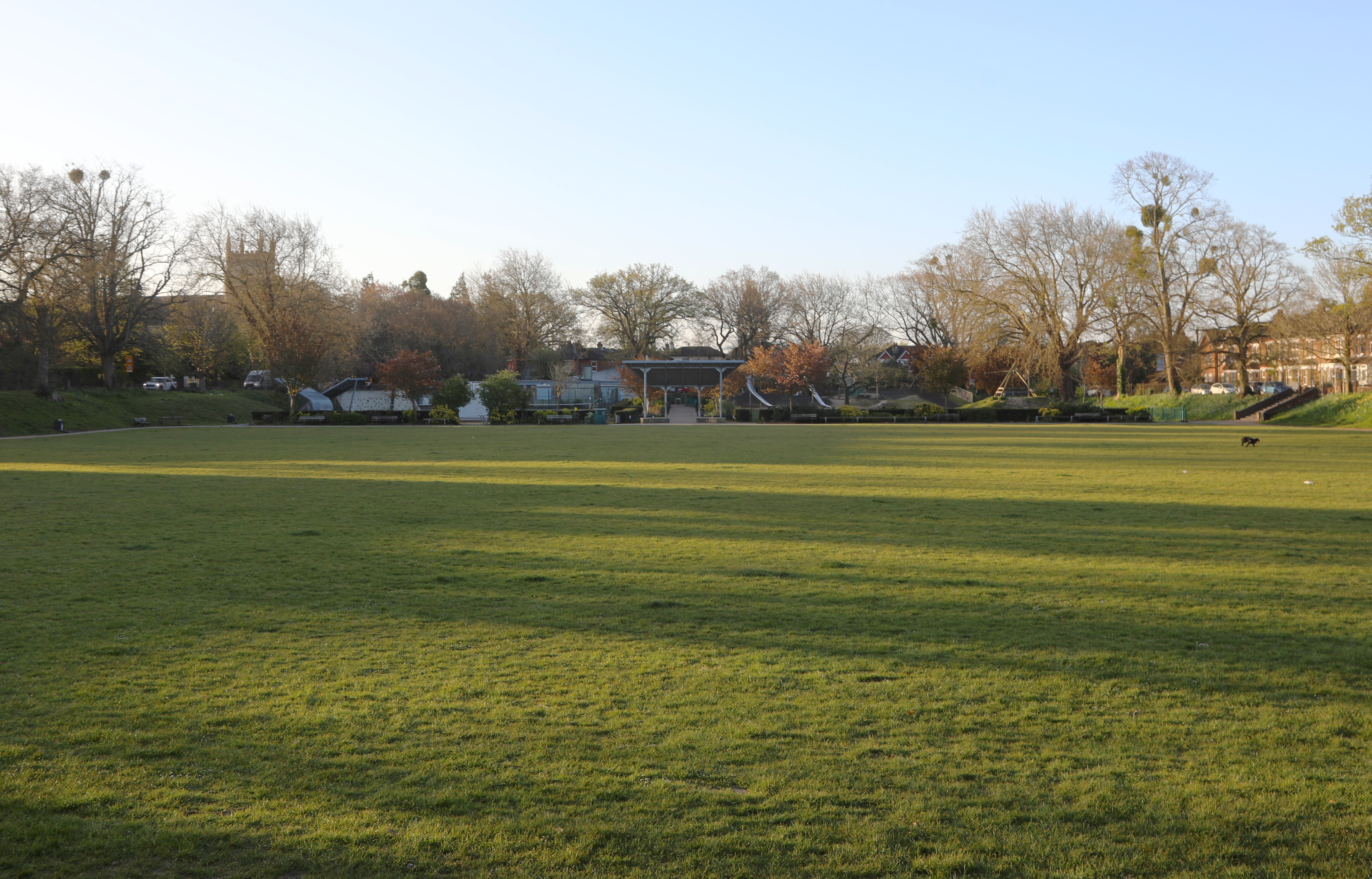
Shirley Pond is a picturesque freshwater body located in Hampshire, England. Covering an area of approximately 2 acres, it is classified as a lake, although its size is more reminiscent of a large pond. Surrounded by lush greenery and nestled within the charming village of Shirley, this serene water feature serves as a popular recreational spot for locals and visitors alike.

The pond is fed by natural springs, ensuring a constant flow of fresh water. Its crystal-clear waters are home to a variety of aquatic plants, including water lilies and reeds, which provide a vibrant and ecologically diverse habitat for numerous species of fish, frogs, and insects. Birdwatchers frequent the area, as the pond attracts a wide range of avian species, including ducks, geese, and herons.

The site offers several amenities to enhance visitors' experiences. A well-maintained footpath encircles the pond, allowing for leisurely strolls and providing opportunities for nature enthusiasts to observe the wildlife up close. Additionally, several benches are strategically placed along the path, providing perfect resting spots and picturesque views of the pond.

Shirley Pond also features a small picnic area, inviting families and friends to gather for outdoor meals amidst the tranquil surroundings. The calmness of the water and the peaceful ambiance make it an ideal location for meditation or simply enjoying a moment of solitude.

Overall, Shirley Pond in Hampshire offers a serene and idyllic natural setting, providing a haven for both wildlife and visitors seeking a peaceful escape from the hustle and bustle of everyday life.

If you have any feedback on the listing, please let us know in the comments section below.

Shirley Pond Images

Images are sourced within 2km of 50.927145/-1.4382627 or Grid Reference SU3914. Thanks to Geograph Open Source API. All images are credited.

Southampton : Millbrook Road West A33 Looking along Millbrook Road West.
Southampton : Millbrook Road West A33
Looking along Millbrook Road West.
Southampton : Third Avenue Looking along Third Avenue off Millbrook Road West.
Southampton : Third Avenue
Looking along Third Avenue off Millbrook Road West.
Southampton : Co-op Food - Petrol Millbrook A petrol station and shop alongside Millbrook Road West.
Southampton : Co-op Food - Petrol Millbrook
A petrol station and shop alongside Millbrook Road West.
Southampton : Millbrook Road West A33 Heading along Millbrook Road West.
Southampton : Millbrook Road West A33
Heading along Millbrook Road West.
Southampton : Lok 'n Store Self Storage A self storage business seen from Millbrook Road West.
Southampton : Lok 'n Store Self Storage
A self storage business seen from Millbrook Road West.
Southampton : Millbrook Flyover A33 Looking along the A33.
Southampton : Millbrook Flyover A33
Looking along the A33.
Southampton : Redbridge Road A33 Looking along Redbridge Road.
Southampton : Redbridge Road A33
Looking along Redbridge Road.
New General Intensive Care Unit, University Hospital Southampton Opened in September 2020, this has been substantially completed during the Covid-19 pandemic: compare <a href="https://www.geograph.org.uk/photo/6472981">SU3915 : Near-empty hospital car park</a>.
New General Intensive Care Unit, University Hospital Southampton
Opened in September 2020, this has been substantially completed during the Covid-19 pandemic: compare SU3915 : Near-empty hospital car park.
New extension, Southampton General Hospital Seen on a Sunday morning, with that rarest of commodities in the foreground: hospital parking spaces!
New extension, Southampton General Hospital
Seen on a Sunday morning, with that rarest of commodities in the foreground: hospital parking spaces!
Businesses on Shirley High Street
Shirley High Street (A3057)
The Shirley Hotel On Shirley High Street.
See <a href="https://www.geograph.org.uk/photo/7302356">SU3913 : Sign for the Shirley Hotel</a> for sign.
The Shirley Hotel
On Shirley High Street. See SU3913 : Sign for the Shirley Hotel for sign.
Sign for the Shirley Hotel See <a href="https://www.geograph.org.uk/photo/7302355">SU3913 : The Shirley Hotel</a> for context.
Sign for the Shirley Hotel
See SU3913 : The Shirley Hotel for context.
The Windsor Castle, Shirley On Shirley High Street.
See <a href="https://www.geograph.org.uk/photo/7302360">SU3913 : Sign for the Windsor Castle, Shirley</a> for sign.
The Windsor Castle, Shirley
On Shirley High Street. See SU3913 : Sign for the Windsor Castle, Shirley for sign.
Sign for the Windsor Castle, Shirley See <a href="https://www.geograph.org.uk/photo/7302357">SU3913 : The Windsor Castle, Shirley</a> for context.
Sign for the Windsor Castle, Shirley
Houses on Romsey Road
Romsey Road (A3057)
Romsey Road (A3057)
Businesses and flats, Mercator Close
Show me another place!

Shirley Pond is located at Grid Ref: SU3914 (Lat: 50.927145, Lng: -1.4382627)

Unitary Authority: Southampton

Police Authority: Hampshire

What 3 Words

///sock.leaps.yards. Near Southampton, Hampshire

Related Wikis

Regents Park Community College

Regents Park Community College is a mixed Comprehensive School in West Southampton, Hampshire, in the south of England. The most recent Ofsted inspection...

St James' Park, Southampton

St James' Park, Southampton is a recreational area situated in the district of Shirley, Southampton opposite St James' Church, Southampton. It is adjacent...

Shirley Baptist Church, Southampton

Shirley Baptist Church is a Baptist church in Southampton. The main church building is situated along Church Street in the district of Shirley. Founded...

Western Community Hospital

The Western Community Hospital is a health facility in William Macleod Way in the Shirley / Millbrook area of Southampton, Hampshire, England. It is managed...
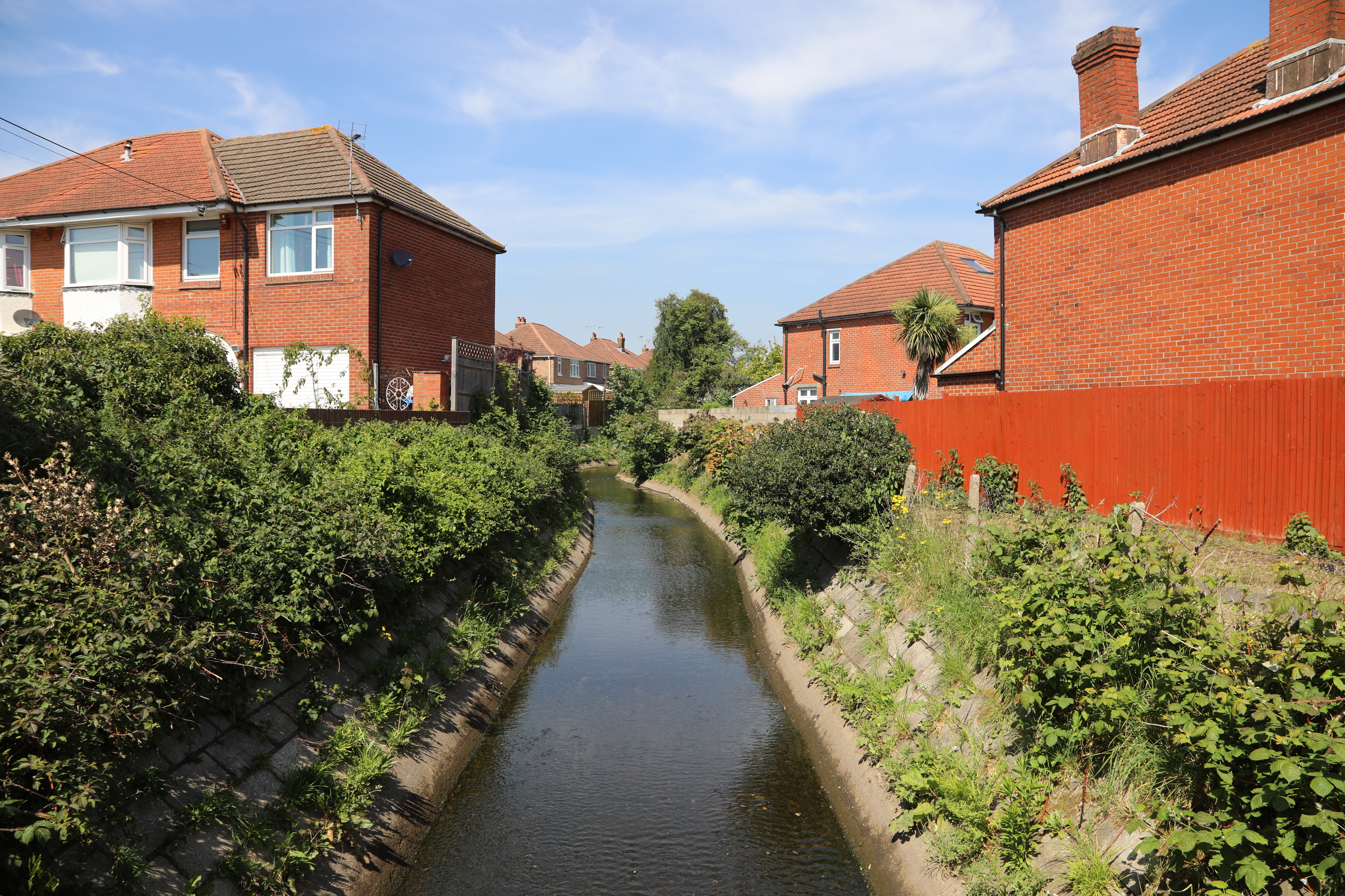
Tanner's Brook

Tanner's Brook is a 7-kilometre (4.3 mi) river that rises in North Baddesley and flows to Southampton Water. The brook's name comes from a 19th-century...

University of Southampton School of Medicine

University of Southampton School of Medicine is a medical school in England. It is part of the University of Southampton with a site at Southampton General...

Shirley Parish Church

St James' by the Park (sometimes known as Shirley Parish Church) is an Anglican parish church which meets in Shirley, Southampton. Following the closure...

Southampton General Hospital

Southampton General Hospital (SGH) is a large teaching hospital in Southampton, Hampshire, England run by University Hospital Southampton NHS Foundation...

Nearby Amenities

Located within 500m of 50.927145,-1.4382627
Shirley
Is In: Southampton, Hampshire, England, UK
Place: suburb
Wikidata: Q7498669
Wikipedia: en:Shirley, Southampton
Lat/Long: 50.9235031/-1.4345775
Mini Roundabout
Lat/Long: 50.9285993/-1.437628
Barrier: bollard
Bollard: fixed
Motor Vehicle: no
Lat/Long: 50.9274489/-1.4314353
Turning Circle
Turning Circle: square
Lat/Long: 50.9274803/-1.4347469
Shirley Warren
Is In: Southampton
Place: suburb
Lat/Long: 50.931405/-1.4388904
Bus Stop
Shirley Precinct
Bench: yes
Bin: yes
Bus: yes
Local Ref: SG
Naptan AtcoCode: 1980SN12368B
Naptan NaptanCode: sohamap
Public Transport: platform
Shelter: yes
Tactile Paving: no
Lat/Long: 50.9234527/-1.4350558
Bus Stop
Shirley Precinct
Bench: yes
Bin: no
Bus: yes
Local Ref: SF
Public Transport: platform
Shelter: yes
Tactile Paving: no
Lat/Long: 50.9233469/-1.434915
Bus Stop
Shirley Precinct
Bench: yes
Bin: yes
Bus: yes
Lit: yes
Local Ref: SH
Naptan AtcoCode: 1980SN12367A
Naptan NaptanCode: sohamat
Public Transport: platform
Shelter: yes
Tactile Paving: no
Lat/Long: 50.9235915/-1.434899
Bus Stop
Shirley Precinct
Bench: yes
Bin: no
Bus: yes
Lit: yes
Local Ref: SI
Naptan AtcoCode: 1980SN120367
Naptan NaptanCode: sohamdg
Public Transport: platform
Shelter: yes
Tactile Paving: no
Lat/Long: 50.9235166/-1.4348126
Bus Stop
Winchester Road
Bench: no
Bin: no
Bus: yes
Lit: yes
Naptan AtcoCode: 1980SN120214
Naptan NaptanCode: sohamaj
Public Transport: platform
Shelter: no
Tactile Paving: no
Lat/Long: 50.9266802/-1.4364543
Bus Stop
Warren Crescent
Bench: yes
Bin: yes
Bus: yes
Lit: no
Naptan AtcoCode: 1980SN120213
Naptan NaptanCode: sohajwp
Public Transport: platform
Shelter: yes
Tactile Paving: no
Lat/Long: 50.9281918/-1.4372724
Bus Stop
Warren Crescent
Bench: no
Bin: no
Bus: yes
Lit: yes
Naptan AtcoCode: 1980SN120211
Naptan NaptanCode: sohajwa
Public Transport: platform
Shelter: no
Tactile Paving: no
Lat/Long: 50.9289762/-1.4379336
Bus Stop
Tremona Court
Bench: no
Bin: no
Bus: yes
Lit: no
Naptan AtcoCode: 1980SNA09197
Naptan NaptanCode: sohjptp
Public Transport: platform
Tactile Paving: no
Lat/Long: 50.9287873/-1.4370303
Bus Stop
Jessamine Road
Bench: no
Bin: no
Bus: yes
Naptan AtcoCode: 1980SN120209
Naptan NaptanCode: sohajta
Public Transport: platform
Shelter: no
Lat/Long: 50.9313632/-1.4393297
Crossing
Crossing: uncontrolled
Crossing Island: yes
Crossing Markings: dots
Lat/Long: 50.9262924/-1.4420607
Post Box
Operator: Royal Mail
Operator Wikidata: Q638098
Ref: SO16 305
Lat/Long: 50.9252335/-1.4397147
Post Box
Brand: Royal Mail
Brand Wikidata: Q638098
Brand Wikipedia: en:Royal Mail
Collection Plate: CP1
Collection Times: Mo-Fr 17:00; Sa 12:15
Operator: Royal Mail
Operator Wikidata: Q638098
Post Box Type: pillar
Ref: SO15 55
Royal Cypher: EIIR
Royal Cypher Wikidata: Q33102113
Lat/Long: 50.9235318/-1.434425
Telephone
Booth: ST6
Check Date: 2022-06-25
Lat/Long: 50.9234437/-1.4344326
Fast Food
Papa John's
Brand: Papa John's
Brand Wikidata: Q2759586
Brand Wikipedia: en:Papa John's Pizza
Check Date: 2024-04-03
Cuisine: pizza
Takeaway: yes
Website: https://www.papajohns.co.uk/stores/southampton-shirley
Lat/Long: 50.9237978/-1.4347735
Atm
Brand: Sainsbury's
Check Date: 2024-04-20
Level: 0
Opening Hours: 24/7
Lat/Long: 50.9235562/-1.434308
Sainsbury's Café
Addr City: Southampton
Addr Housenumber: 1
Addr Postcode: SO15 5LL
Addr Street: Redcar Street
Brand: Sainsbury's
Brand Wikidata: Q152096
Check Date: 2024-04-03
Cuisine: coffee_shop
Disused Amenity: cafe
Phone: +44 23 8077 2273
Takeaway: yes
Lat/Long: 50.9234693/-1.4343252
Bus Stop
Grange Road
Bench: yes
Bin: yes
Bus: yes
Covered: yes
Naptan AtcoCode: 1980SN120217
Naptan NaptanCode: sohajtp
Public Transport: platform
Shelter: yes
Lat/Long: 50.9252182/-1.4388804
Library
Shirley Library
Check Date: 2023-04-29
Operator: Southampton City Council
Wikidata: Q55114721
Lat/Long: 50.923946/-1.4343362
Turning Circle
Lat/Long: 50.9263512/-1.4430086
Bus Stop
Arliss Road
Bench: no
Bin: no
Bus: yes
Covered: no
Naptan AtcoCode: 1980SN120207
Naptan Bearing: NW
Naptan NaptanCode: sohajdj
Public Transport: platform
Shelter: no
Source: Bing
Lat/Long: 50.9269546/-1.4433905
Bus Stop
Arliss Road
Bench: yes
Bus: yes
Covered: yes
Naptan AtcoCode: 1980SN120208
Naptan Bearing: SE
Naptan NaptanCode: sohajdm
Public Transport: platform
Shelter: yes
Source: Bing
Lat/Long: 50.9272592/-1.4436447
Bus Stop
Irving Road
Bench: no
Bus: yes
Covered: no
Naptan AtcoCode: 1980SN121040
Naptan NaptanCode: sohajam
Public Transport: platform
Shelter: no
Source: Bing
Lat/Long: 50.9264695/-1.4446671
Bus Stop
Maybush Court
Bench: yes
Bin: no
Bus: yes
Covered: yes
Naptan Bearing: NW
Public Transport: platform
Shelter: yes
Source: Bing
Lat/Long: 50.9277635/-1.4446511
Crossing
Crossing: unmarked
Crossing Island: no
Crossing Markings: no
Kerb: lowered
Tactile Paving: no
Lat/Long: 50.9273858/-1.4323816
Crossing
Crossing: uncontrolled
Crossing Island: no
Crossing Markings: zebra
Tactile Paving: yes
Lat/Long: 50.9240289/-1.4340019
Post Box
Check Date Collection Times: 2022-06-22
Collection Plate: CP1D
Collection Times: Mo-Fr 09:00; Sa 07:00
Operator: Royal Mail
Operator Wikidata: Q638098
Post Box Type: pillar
Ref: SO15 378D
Royal Cypher: GR
Royal Cypher Wikidata: Q33102273
Lat/Long: 50.9263769/-1.4357965
Post Office
Shirley Precinct Post Office
Addr City: Southampton
Addr Country: GB
Addr Housenumber: 101
Addr Postcode: SO16 4EY
Addr Street: High Street
Addr Village: Shirley
Check Date: 2024-04-20
Opening Hours: Mo-Fr 07:00-17:30; Sa 08:30-15:30
Ref Pol Id: 9814
Source: Bing
Lat/Long: 50.9237267/-1.4345584
Traffic Calming: table
Lat/Long: 50.9252742/-1.4441452
Traffic Calming: table
Lat/Long: 50.9257594/-1.4443415
Traffic Calming: table
Lat/Long: 50.9253089/-1.444526
Traffic Calming: table
Lat/Long: 50.9254754/-1.4437133
Pharmacy
Lloyds Pharmacy
Brand: Lloyds Pharmacy
Brand Wikidata: Q6662870
Brand Wikipedia: en:LloydsPharmacy
Check Date: 2023-04-29
Dispensing: yes
Drive Through: no
Healthcare: pharmacy
Lat/Long: 50.9236982/-1.4344367
Traffic Calming: hump
Lat/Long: 50.9284804/-1.4388059
Traffic Calming: hump
Lat/Long: 50.9288597/-1.4408358
Traffic Signals
Traffic Signals: signal
Traffic Signals Direction: forward
Lat/Long: 50.9262898/-1.4415104
Crossing
Crossing: traffic_signals
Crossing Ref: pelican
Tactile Paving: yes
Lat/Long: 50.9261016/-1.4421798
Traffic Calming: table
Lat/Long: 50.931071/-1.4392018
Turning Circle
Lat/Long: 50.9287221/-1.442016
Crossing
Crossing: unmarked
Crossing Island: no
Crossing Markings: no
Kerb: lowered
Tactile Paving: yes
Lat/Long: 50.9310965/-1.4391115
Bonmarché
Brand: Bonmarché
Brand Wikidata: Q4942146
Brand Wikipedia: en:Bonmarché
Check Date: 2024-04-03
Shop: clothes
Lat/Long: 50.9238984/-1.4349719
Bus Stop
Jessamine Road
Bench: no
Bin: no
Bus: yes
Naptan AtcoCode: 1980SN120210
Naptan NaptanCode: sohajtg
Public Transport: platform
Shelter: no
Lat/Long: 50.9308348/-1.439118
Barnardo's
Addr City: Southampton
Addr Housename: Unit 10
Addr Postcode: SO16 4EY
Addr Street: Shirley Precinct
Brand: Barnardo's
Brand Wikidata: Q2884670
Brand Wikipedia: en:Barnardo's
Check Date: 2024-04-03
Opening Hours: Mo-Sa 09:00-18:00; Su 10:00-16:00
Shop: charity
Lat/Long: 50.9241159/-1.4345788
Dentist
ADP Dental Co
Healthcare: dentist
Lat/Long: 50.9250026/-1.4344594
Bus Stop
Grange Road
Bench: no
Bin: no
Bus: yes
Covered: no
Naptan AtcoCode: 1980SN120216
Naptan NaptanCode: sohajtd
Public Transport: platform
Shelter: no
Tactile Paving: no
Lat/Long: 50.9254186/-1.4394237
Bus Stop
Irving Road
Bench: yes
Bus: yes
Covered: yes
Naptan AtcoCode: 1980SN121037
Naptan NaptanCode: sohajaw
Public Transport: platform
Shelter: yes
Lat/Long: 50.9266187/-1.4453455
Traffic Calming: bump
Lat/Long: 50.9300659/-1.4335309
Post Box
Brand: Royal Mail
Brand Wikidata: Q638098
Brand Wikipedia: en:Royal Mail
Collection Plate: CP1
Collection Times: Mo-Fr 17:00; Sa 12:00
Operator: Royal Mail
Operator Wikidata: Q638098
Post Box Type: pillar
Ref: SO16 25
Royal Cypher: GR
Royal Cypher Wikidata: Q33102273
Lat/Long: 50.930131/-1.4385091
Fast Food
Lucky House
Check Date: 2024-04-03
Cuisine: chinese
Lat/Long: 50.9297366/-1.4381382
Bicycle Parking
Bicycle Parking: stands
Capacity: 12
Check Date Capacity: 2022-07-14
Covered: no
Lat/Long: 50.9239086/-1.4351349
Bicycle Parking
Bicycle Parking: stands
Capacity: 22
Covered: no
Lat/Long: 50.9237529/-1.4342954
Bicycle Parking
Bicycle Parking: stands
Capacity: 4
Check Date Capacity: 2022-12-03
Covered: no
Lat/Long: 50.923703/-1.4347312
Bicycle Parking
Bicycle Parking: stands
Capacity: 4
Check Date Capacity: 2022-12-03
Covered: no
Lat/Long: 50.923763/-1.4349056
Bicycle Parking
Bicycle Parking: stands
Capacity: 4
Check Date Capacity: 2022-12-03
Covered: no
Lat/Long: 50.9238172/-1.4350625
Bicycle Parking
Bicycle Parking: stands
Capacity: 4
Check Date Capacity: 2022-12-03
Covered: no
Lat/Long: 50.9236489/-1.4345783
Bicycle Parking
Bicycle Parking: stands
Capacity: 32
Covered: no
Lat/Long: 50.9240344/-1.4341894
Crossing
Crossing: traffic_signals
Crossing Ref: pelican
Lat/Long: 50.9260636/-1.4420292
Crossing
Crossing: unmarked
Crossing Island: no
Crossing Markings: no
Kerb: lowered
Tactile Paving: yes
Lat/Long: 50.9263947/-1.4359034
Bicycle Parking
Lat/Long: 50.9238733/-1.4336739
Crossing
Crossing: unmarked
Crossing Island: no
Crossing Markings: no
Tactile Paving: no
Lat/Long: 50.9273641/-1.4324914
Traffic Signals
Traffic Signals: signal
Traffic Signals Direction: forward
Lat/Long: 50.9236681/-1.435196
Crossing
Crossing: uncontrolled
Crossing Island: no
Crossing Markings: zebra
Tactile Paving: yes
Lat/Long: 50.9245075/-1.4335667
Crossing
Button Operated: yes
Crossing: traffic_signals
Crossing Island: no
Kerb: lowered
Tactile Paving: yes
Traffic Signals: pedestrian
Traffic Signals Sound: yes
Traffic Signals Vibration: yes
Lat/Long: 50.9237287/-1.4352777
Crossing
Button Operated: yes
Crossing: traffic_signals
Crossing Island: no
Crossing Markings: no
Kerb: lowered
Tactile Paving: yes
Traffic Signals Sound: no
Traffic Signals Vibration: yes
Lat/Long: 50.9274438/-1.4325126
Crossing
Crossing: unmarked
Crossing Island: no
Crossing Markings: no
Kerb: lowered
Tactile Paving: no
Lat/Long: 50.9275764/-1.4323571
Crossing
Crossing: unmarked
Crossing Island: no
Crossing Markings: no
Kerb: lowered
Tactile Paving: no
Lat/Long: 50.9275832/-1.4322107
Crossing
Crossing: unmarked
Crossing Island: no
Crossing Markings: no
Kerb: lowered
Tactile Paving: yes
Lat/Long: 50.927691/-1.431749
Crossing
Crossing: unmarked
Crossing Island: no
Crossing Markings: no
Kerb: lowered
Tactile Paving: yes
Lat/Long: 50.9280705/-1.4313309
Crossing
Crossing: unmarked
Crossing Island: no
Crossing Markings: no
Kerb: lowered
Tactile Paving: yes
Lat/Long: 50.9311473/-1.4392499
Crossing
Crossing: unmarked
Crossing Island: no
Crossing Markings: no
Kerb: lowered
Tactile Paving: yes
Lat/Long: 50.9309611/-1.4391268
Crossing
Crossing: unmarked
Crossing Island: no
Crossing Markings: no
Kerb: lowered
Tactile Paving: yes
Lat/Long: 50.9310411/-1.4393042
Crossing
Crossing: unmarked
Crossing Island: no
Crossing Markings: no
Kerb: lowered
Tactile Paving: yes
Lat/Long: 50.9291793/-1.4381045
Crossing
Crossing: unmarked
Crossing Island: no
Crossing Markings: no
Kerb: lowered
Tactile Paving: yes
Lat/Long: 50.9286333/-1.437455
Crossing
Crossing: unmarked
Crossing Island: no
Crossing Markings: no
Kerb: lowered
Tactile Paving: yes
Lat/Long: 50.9285753/-1.4377647
Crossing
Button Operated: yes
Crossing: traffic_signals
Crossing Island: no
Kerb: lowered
Tactile Paving: yes
Traffic Signals Sound: no
Traffic Signals Vibration: yes
Lat/Long: 50.9264307/-1.4360109
Crossing
Crossing: unmarked
Crossing Island: no
Crossing Markings: no
Kerb: lowered
Tactile Paving: yes
Lat/Long: 50.9263505/-1.436044
Cycleway: asl
Direction: backward
Lat/Long: 50.9263349/-1.4360008
Traffic Signals
Traffic Signals: signal
Traffic Signals Direction: backward
Lat/Long: 50.9263121/-1.4359378
Cycleway: asl
Direction: forward
Lat/Long: 50.9265581/-1.4362862
Traffic Calming: chicane
Lat/Long: 50.9312096/-1.4363797
Check Date: 2022-06-25
Traffic Calming: choker
Lat/Long: 50.9306783/-1.4354467
Crossing
Crossing: unmarked
Crossing Island: no
Crossing Markings: no
Kerb: lowered
Tactile Paving: yes
Traffic Calming: table
Lat/Long: 50.9288931/-1.4378318
Crossing
Bicycle: yes
Button Operated: yes
Crossing: traffic_signals
Crossing Island: no
Crossing Ref: toucan
Kerb: lowered
Segregated: no
Tactile Paving: yes
Lat/Long: 50.9253223/-1.4391762
Traffic Signals
Traffic Signals: signal
Traffic Signals Direction: backward
Lat/Long: 50.9264414/-1.4359529
Traffic Signals
Traffic Signals: signal
Traffic Signals Direction: forward
Lat/Long: 50.9263556/-1.436493
Traffic Signals
Traffic Signals: signal
Traffic Signals Direction: forward
Lat/Long: 50.9266013/-1.4363145
Fast Food
Subway
Brand: Subway
Brand Wikidata: Q244457
Brand Wikipedia: en:Subway (restaurant)
Check Date: 2024-04-03
Contact Website: https://restaurants.subway.com/united-kingdom/en/southampton/109-shirley-high-street
Cuisine: sandwich
Takeaway: yes
Lat/Long: 50.9238172/-1.4348335
Disused Shop: yes
Lat/Long: 50.9238375/-1.4348925
Fountain
Water: water_well
Lat/Long: 50.9235672/-1.4345718
Bench
Lat/Long: 50.9271008/-1.4389622
Crossing
Crossing: uncontrolled
Crossing Island: no
Crossing Markings: zebra
Kerb: flush
Tactile Paving: yes
Traffic Calming: table
Lat/Long: 50.9246517/-1.4334822
Childcare
Little Caterpillars Preschool
Check Date: 2024-04-09
Lat/Long: 50.9269695/-1.4363377
Entrance: yes
Lat/Long: 50.9263507/-1.4342669
Entrance: yes
Lat/Long: 50.9263052/-1.4341274
Crossing
Button Operated: yes
Crossing: traffic_signals
Crossing Island: no
Kerb: lowered
Tactile Paving: yes
Traffic Signals: pedestrian
Traffic Signals Sound: yes
Traffic Signals Vibration: yes
Lat/Long: 50.9239108/-1.4352807
Traffic Calming: table
Lat/Long: 50.9250387/-1.4339932
Give Way
Direction: forward
Lat/Long: 50.925147/-1.4341878
NatWest
Brand: NatWest
Brand Wikidata: Q2740021
Brand Wikipedia: en:NatWest
Cash In: no
Check Date: 2024-04-20
Disused Amenity: atm
Operator: NatWest
Operator Wikidata: Q2740021
Lat/Long: 50.9240312/-1.4354787
Barrier: bollard
Lat/Long: 50.9250374/-1.4379298
Motorcycle Parking
Access: customers
Covered: no
Lat/Long: 50.9238994/-1.433618
Crossing
Crossing Markings: no
Crossing Signals: no
Tactile Paving: yes
Lat/Long: 50.9266066/-1.4429482
Crossing
Crossing Markings: no
Crossing Signals: no
Tactile Paving: yes
Lat/Long: 50.9267119/-1.4430595
Crossing
Crossing: unmarked
Crossing Island: no
Crossing Markings: no
Lat/Long: 50.9283998/-1.4391388
Crossing
Crossing: unmarked
Crossing Markings: no
Lat/Long: 50.9281875/-1.4390646
Crossing
Crossing: unmarked
Crossing Island: no
Crossing Markings: no
Tactile Paving: no
Lat/Long: 50.9286686/-1.4405987
Crossing
Crossing: unmarked
Crossing Island: no
Crossing Markings: no
Tactile Paving: no
Lat/Long: 50.9297783/-1.4419829
Crossing
Crossing: unmarked
Crossing Island: no
Crossing Markings: no
Tactile Paving: yes
Lat/Long: 50.9302004/-1.4421719
Crossing
Crossing: unmarked
Crossing Island: no
Crossing Markings: no
Tactile Paving: yes
Lat/Long: 50.9303391/-1.4420742
Crossing
Crossing: unmarked
Crossing Island: no
Crossing Markings: no
Tactile Paving: yes
Lat/Long: 50.9294971/-1.4355506
Crossing
Button Operated: yes
Crossing: traffic_signals
Crossing Island: no
Kerb: lowered
Tactile Paving: yes
Traffic Signals: pedestrian
Traffic Signals Sound: yes
Traffic Signals Vibration: yes
Lat/Long: 50.923743/-1.4354767
Crossing
Button Operated: yes
Crossing: traffic_signals
Crossing Island: no
Kerb: lowered
Tactile Paving: yes
Traffic Signals: pedestrian
Traffic Signals Sound: yes
Traffic Signals Vibration: yes
Lat/Long: 50.9239118/-1.4355166
Bicycle Parking
Bicycle Parking: stands
Capacity: 4
Covered: no
Lat/Long: 50.9235532/-1.4351859
Claire's Cutting Room
Check Date: 2024-04-03
Female: yes
Shop: hairdresser
Lat/Long: 50.9294065/-1.4379137
Power: transformer
Lat/Long: 50.9245086/-1.4404083
Traffic Calming: table
Lat/Long: 50.9303214/-1.4387297
Give Way
Direction: forward
Lat/Long: 50.9263457/-1.4359024
Shirley Park
Place: suburb
Lat/Long: 50.9255506/-1.4424404
Old Shirley
Place: suburb
Lat/Long: 50.9288648/-1.4425185
Entrance: yes
Lat/Long: 50.9274203/-1.4452348
Entrance: yes
Lat/Long: 50.9276341/-1.4452342
Entrance: yes
Lat/Long: 50.9274821/-1.4449996
Entrance: yes
Lat/Long: 50.9275313/-1.4449934
Traffic Signals
Traffic Signals: signal
Traffic Signals Direction: forward
Lat/Long: 50.9261101/-1.4416507
Traffic Signals
Traffic Signals: signal
Traffic Signals Direction: forward
Lat/Long: 50.9260703/-1.442233
Traffic Signals
Traffic Signals: signal
Traffic Signals Direction: backward
Lat/Long: 50.9263197/-1.4421203
Traffic Signals
Traffic Signals: signal
Traffic Signals Direction: forward
Lat/Long: 50.9274258/-1.4325536
Traffic Signals
Traffic Signals: signal
Traffic Signals Direction: forward
Lat/Long: 50.927611/-1.4323918
Traffic Signals
Traffic Signals: signal
Traffic Signals Direction: forward
Lat/Long: 50.9273406/-1.4324087
Traffic Signals
Traffic Signals: signal
Traffic Signals Direction: backward
Lat/Long: 50.9276077/-1.4321538
Traffic Signals
Traffic Signals: pedestrian_crossing
Traffic Signals Direction: backward
Lat/Long: 50.9253415/-1.4392477
Traffic Signals
Traffic Signals: pedestrian_crossing
Traffic Signals Direction: forward
Lat/Long: 50.925309/-1.4391209
Traffic Signals
Traffic Signals: signal
Traffic Signals Direction: forward
Lat/Long: 50.9237187/-1.4355076
Cycleway: asl
Direction: backward
Lat/Long: 50.9239337/-1.4355452
Traffic Signals
Traffic Signals: signal
Traffic Signals Direction: backward
Lat/Long: 50.9239729/-1.4355962
Traffic Signals
Traffic Signals: signal
Traffic Signals Direction: backward
Lat/Long: 50.9239519/-1.4352457
Cycleway: asl
Direction: forward
Lat/Long: 50.923704/-1.4352438
Traffic Calming: hump
Lat/Long: 50.9299881/-1.4420496
Traffic Calming: hump
Lat/Long: 50.9292894/-1.4414935
Traffic Calming: hump
Lat/Long: 50.9285355/-1.4398466
Access: customers
Entrance: main
Lat/Long: 50.923654/-1.4342627
Access: customers
Entrance: main
Lat/Long: 50.9235862/-1.4343233
Bench
Backrest: yes
Lat/Long: 50.9278359/-1.4312459
Crossing
Crossing: unmarked
Crossing Markings: no
Lat/Long: 50.925997/-1.4335403
Surface: asphalt
Traffic Calming: choker
Lat/Long: 50.9278861/-1.4326892
Traffic Calming: bump
Lat/Long: 50.928372/-1.4324636
Traffic Calming: bump
Lat/Long: 50.9281949/-1.4328634
Turning Circle
Turning Circle: square
Lat/Long: 50.9276927/-1.4329415
Traffic Calming: bump
Lat/Long: 50.9301557/-1.4333036
Traffic Calming: island
Lat/Long: 50.9261876/-1.4383149
Entrance: yes
Lat/Long: 50.9308445/-1.4341994
Barrier: lift_gate
Lat/Long: 50.9304672/-1.4348804
Traffic Calming: table
Lat/Long: 50.9257932/-1.4437562
Traffic Calming: table
Lat/Long: 50.9248054/-1.4443555
Childcare
Co-operative Childcare
Check Date: 2024-04-03
Lat/Long: 50.9298775/-1.441161
Addr City: Southampton
Addr Housenumber: 6
Addr Postcode: SO15 5SQ
Addr Street: Hampton Close
Lat/Long: 50.9265109/-1.4323689
Addr City: Southampton
Addr Housenumber: 6
Addr Postcode: SO15 5SQ
Addr Street: Hampton Close
Fixme: new build home address to be added
Lat/Long: 50.9260998/-1.4320684
The data included in this document is from www.openstreetmap.org. The data is made available under ODbL.

Have you been to Shirley Pond?

Leave your review of Shirley Pond below (or comments, questions and feedback).