Mill Dam

Lake, Pool, Pond, Freshwater Marsh in Northumberland

England

Mill Dam

Static caravan site at Haltwhistle
Static caravan site at Haltwhistle Credit: Chris Morgan

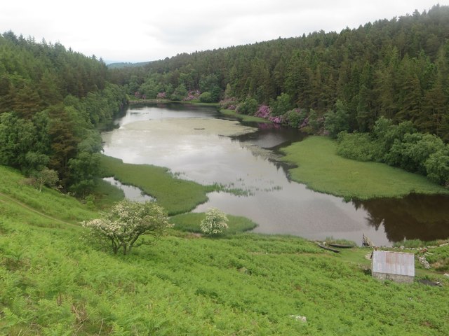
Mill Dam is a freshwater ecosystem located in Northumberland, England. It is a combination of a lake, pool, pond, and freshwater marsh, making it a diverse and important habitat for various species of plants and animals.

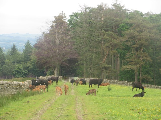
The main feature of Mill Dam is the lake, which is a large body of freshwater covering an area of approximately 10 hectares. The lake is surrounded by dense vegetation, including reeds and grasses, which provide shelter and nesting sites for birds and other small animals. The lake is also home to several species of fish, such as perch, pike, and roach, which thrive in the nutrient-rich waters.

Adjacent to the lake is a smaller pool, which is connected to the main body of water through a narrow channel. The pool is shallower and contains a variety of aquatic plants, such as water lilies and pondweed, which provide food and shelter for insects and amphibians.

Beyond the pool is a smaller pond, which is often frequented by waterfowl, including ducks and swans. The pond is surrounded by a mixture of grassland and shrubs, creating a diverse habitat for a wide range of bird species.

Finally, surrounding the lake, pool, and pond is a freshwater marsh. This marsh is characterized by wet, marshy ground and a variety of emergent vegetation, such as sedges and rushes. The marsh provides an important habitat for wetland birds, such as herons and bitterns, as well as insects and small mammals.

Overall, Mill Dam in Northumberland is a unique and important freshwater ecosystem, supporting a diverse range of plants and animals. It is not only a beautiful natural area, but also a valuable site for scientific research and wildlife conservation.

If you have any feedback on the listing, please let us know in the comments section below.

Mill Dam Images

Images are sourced within 2km of 54.951922/-2.4375096 or Grid Reference NY7262. Thanks to Geograph Open Source API. All images are credited.

Static caravan site at Haltwhistle
Alston Arches Viaduct Formerly carried the Alston branch railway (closed 1976) over the River South Tyne.  The viaduct now carries a footpath and cycleway. Note the secondary arches within the piers.
Alston Arches Viaduct
Formerly carried the Alston branch railway (closed 1976) over the River South Tyne. The viaduct now carries a footpath and cycleway. Note the secondary arches within the piers.
Arches within arches The piers of the old Alston Arches rail Viaduct are pierced with secondary arches.
Arches within arches
The piers of the old Alston Arches rail Viaduct are pierced with secondary arches.
Alston Arches Viaduct crossing the River South Tyne, Haltwhistle A stone arched viaduct which once carried the Haltwhistle to Alston branch railway across the River South Tyne. The viaduct is now disused.
Alston Arches Viaduct crossing the River South Tyne, Haltwhistle
A stone arched viaduct which once carried the Haltwhistle to Alston branch railway across the River South Tyne. The viaduct is now disused.
Trees in Bellister Wood Some of the trees on the bank on which Bellister Wood stands.
Trees in Bellister Wood
Some of the trees on the bank on which Bellister Wood stands.
Field edge footpath Looking along the line of a public footpath which follows the edge of this grass field beside Bellister Wood.
Field edge footpath
Looking along the line of a public footpath which follows the edge of this grass field beside Bellister Wood.
Cattle on Broomhouse Common A small number of cattle observing me passing across Broomhouse Common close to where they were grazing.
Cattle on Broomhouse Common
A small number of cattle observing me passing across Broomhouse Common close to where they were grazing.
Footpath crossing Broomhouse Common A public footpath crossing the lumps and bumps of Broomhouse Common.
Footpath crossing Broomhouse Common
A public footpath crossing the lumps and bumps of Broomhouse Common.
Stile on Broomhouse Common A stile crossing a stone wall on the path from Broomhouse Common to Warren House.
Stile on Broomhouse Common
A stile crossing a stone wall on the path from Broomhouse Common to Warren House.
Warren House, Watch Hill Warren House is a derelict shepherds house sheltered by a couple of small woodlands on Watch Hill.
Warren House, Watch Hill
Warren House is a derelict shepherds house sheltered by a couple of small woodlands on Watch Hill.
Track on Watch Hill A farm track on grassland at Watch Hill.
Track on Watch Hill
A farm track on grassland at Watch Hill.
Grassland and plantation Grassland in front of a large plantation. The gulley in the middle of the photo has a large mass of purple flowering shrubs on its sides.
Grassland and plantation
Grassland in front of a large plantation. The gulley in the middle of the photo has a large mass of purple flowering shrubs on its sides.
Farm track approaching Lake Wood Looking along the farm track and public footpath as it approaches the large Lake Wood plantation.
Farm track approaching Lake Wood
Looking along the farm track and public footpath as it approaches the large Lake Wood plantation.
The Lake Named on Ordnance Survey maps imaginatively as The Lake this body of water sits in a large gulley, partially surrounded by the equally imaginatively named Lake Wood plantation.
The Lake
Named on Ordnance Survey maps imaginatively as The Lake this body of water sits in a large gulley, partially surrounded by the equally imaginatively named Lake Wood plantation.
Grass field between Lake Wood and Sunny Plantation A field between Lake Wood and Sunny Plantation is occupied by a herd of suckler cows and their calves. They are standing on a track which is also a public footpath.
Grass field between Lake Wood and Sunny Plantation
A field between Lake Wood and Sunny Plantation is occupied by a herd of suckler cows and their calves. They are standing on a track which is also a public footpath.
Track through Sunny Plantation Looking along the track through Sunny Plantation which is also a public footpath.
Track through Sunny Plantation
Looking along the track through Sunny Plantation which is also a public footpath.
Road south of Plenmeller Looking towards Haltwhistle on the country road to the south of Plenmeller.
Road south of Plenmeller
Looking towards Haltwhistle on the country road to the south of Plenmeller.
East Plenmeller Farm The entrance into the steading of East Plenmeller Farm. Lots of aged farm machinery was dotted around the yard the vast majority of which had seen substantially better days.
East Plenmeller Farm
The entrance into the steading of East Plenmeller Farm. Lots of aged farm machinery was dotted around the yard the vast majority of which had seen substantially better days.
Show me another place!

Mill Dam is located at Grid Ref: NY7262 (Lat: 54.951922, Lng: -2.4375096)

Unitary Authority: Northumberland

Police Authority: Northumbria

What 3 Words

///dive.intelligible.dried. Near Haltwhistle, Northumberland

Related Wikis

Unthank, Haltwhistle

Unthank is a village near Haltwhistle in Northumberland, England. It is first mentioned in writing as Unthanc around 1200. == Governance == Unthank is...

Unthank Hall

Unthank Hall is a Grade II listed property now serving as commercial offices, situated on the southern bank of the River South Tyne east of Plenmeller...

Plenmeller

Plenmeller is a village and former civil parish, now in the parish of Plenmeller with Whitfield, in Northumberland, England about a mile (1½ km) southeast...

Haltwhistle Burn

The Haltwhistle Burn is a river which lies to the east of the Northumbrian town of Haltwhistle. Rising in the peaty uplands below the ridge of the Whin...

Nearby Amenities

Located within 500m of 54.951922,-2.4375096
Hirst Top
Place: locality
Lat/Long: 54.9535696/-2.4435652
Barrier: cattle_grid
Lat/Long: 54.9530663/-2.4419348
The data included in this document is from www.openstreetmap.org. The data is made available under ODbL.

Have you been to Mill Dam?

Leave your review of Mill Dam below (or comments, questions and feedback).