Baystone Bank Reservoir

Lake, Pool, Pond, Freshwater Marsh in Cumberland Copeland

England

Baystone Bank Reservoir

A5093 at The Green village boundary
A5093 at The Green village boundary Credit: Colin Pyle

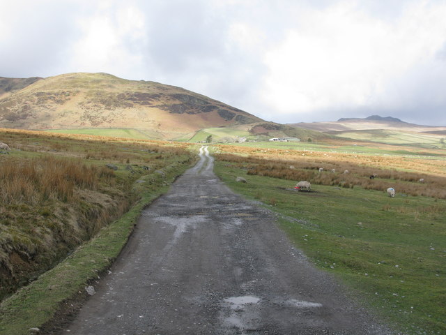
Baystone Bank Reservoir, located in Cumberland, is a picturesque freshwater body encompassing an area of about 50 acres. This serene reservoir is often referred to as a lake due to its size and features. Nestled amidst lush green surroundings, it offers a tranquil and idyllic retreat for nature enthusiasts and those seeking a peaceful escape.

The reservoir's crystal-clear waters are fed by natural springs and streams, ensuring a constant flow of freshwater. Its depth varies across different sections, with the deepest point reaching around 20 feet. The shoreline is predominantly rocky, interspersed with patches of sandy beaches, providing ample space for visitors to relax and enjoy the scenic beauty.

Baystone Bank Reservoir is home to a diverse array of aquatic flora and fauna. The tranquil waters support a thriving ecosystem, with various species of fish, including bass, trout, and catfish, making it a popular destination for fishing enthusiasts. The calm and undisturbed environment also attracts a wide range of bird species, making it an ideal spot for birdwatching.

Surrounding the reservoir, a lush freshwater marsh ecosystem has developed, further enhancing the biodiversity of the area. The marshland is characterized by a variety of wetland plants, such as cattails, reeds, and water lilies, providing a habitat for numerous amphibians, reptiles, and waterfowl.

Baystone Bank Reservoir is a haven for outdoor activities. Boating and kayaking are popular among visitors, allowing them to explore the reservoir's nooks and crannies. Hiking trails around the reservoir offer scenic views and opportunities for wildlife spotting. Additionally, designated picnic areas provide a perfect spot for families and friends to gather and enjoy a day out in nature.

Overall, Baystone Bank Reservoir in Cumberland is a natural gem that offers a blend of tranquility, biodiversity, and recreational opportunities, making it a cherished destination for locals and tourists alike.

If you have any feedback on the listing, please let us know in the comments section below.

Baystone Bank Reservoir Images

Images are sourced within 2km of 54.262102/-3.2732909 or Grid Reference SD1785. Thanks to Geograph Open Source API. All images are credited.

A5093 at The Green village boundary
The Punch Bowl Inn, The Green, Millom
Descending on path below Gray Stones, Black Combe
Descending on path below Grey Stones - view towards Knott Hill
Ordnance Survey Cut Mark This OS cut mark can be found adjacent to the letter box at Broadgate. It marks a point 107.274m above mean sea level.
Ordnance Survey Cut Mark
This OS cut mark can be found adjacent to the letter box at Broadgate. It marks a point 107.274m above mean sea level.
Ordnance Survey Cut Mark This OS cut mark can be found on Old Hall Cottage. It marks a point 39.156m above mean sea level.
Ordnance Survey Cut Mark
This OS cut mark can be found on Old Hall Cottage. It marks a point 39.156m above mean sea level.
Ordnance Survey Cut Mark This OS cut mark can be found on Briar Dene. It marks a point 19.020m above mean sea level.
Ordnance Survey Cut Mark
This OS cut mark can be found on Briar Dene. It marks a point 19.020m above mean sea level.
Ordnance Survey Cut Mark This OS cut mark can be found on a large rock to the west of the track.
Ordnance Survey Cut Mark
This OS cut mark can be found on a large rock to the west of the track.
Start of the track to the Swinside Stone Circle The track branching off to the left leads to the Stone Circle and Swinside Farm.
Start of the track to the Swinside Stone Circle
The track branching off to the left leads to the Stone Circle and Swinside Farm.
Track to the Swinside Stone Circle A rough track which also leads to Swinside Farm. Swinside Fell is in the background.
Track to the Swinside Stone Circle
A rough track which also leads to Swinside Farm. Swinside Fell is in the background.
Boundary Stone Toppled and damaged, over stream, south side of the A595.
Boundary Stone
Toppled and damaged, over stream, south side of the A595.
Ordnance Survey Cut Mark This OS cut mark can be found on the gatepost south side of the road. It marks a point 59.576m above mean sea level.
Ordnance Survey Cut Mark
This OS cut mark can be found on the gatepost south side of the road. It marks a point 59.576m above mean sea level.
Ordnance Survey Cut Mark This OS cut mark can be found on the large boulder in the wall SE side of the road. It marks a point 99.048m above mean sea level.
Ordnance Survey Cut Mark
This OS cut mark can be found on the large boulder in the wall SE side of the road. It marks a point 99.048m above mean sea level.
Ordnance Survey OSBM Bolt This OS Bolt can be found on the large boulder at the side of the barn at Low Broadgate. It marks a point 81.764m above mean sea level.
Ordnance Survey OSBM Bolt
This OS Bolt can be found on the large boulder at the side of the barn at Low Broadgate. It marks a point 81.764m above mean sea level.
Ordnance Survey Cut Mark This OS cut mark can be found on the wall NW side of the road. It marks a point 98.207m above mean sea level.
Ordnance Survey Cut Mark
This OS cut mark can be found on the wall NW side of the road. It marks a point 98.207m above mean sea level.
Ordnance Survey Flush Bracket (G3077) This OS Flush Bracket can be found on The Oaks. It marks a point 35.752m above mean sea level.
Ordnance Survey Flush Bracket (G3077)
This OS Flush Bracket can be found on The Oaks. It marks a point 35.752m above mean sea level.
Ordnance Survey Cut Mark This OS cut mark can be found on the gatepost NE side of the road. It marks a point 59.489m above mean sea level.
Ordnance Survey Cut Mark
This OS cut mark can be found on the gatepost NE side of the road. It marks a point 59.489m above mean sea level.
Elf Hall Country Lane near Elf Hall, Cumbria.
Elf Hall
Country Lane near Elf Hall, Cumbria.
Show me another place!

Baystone Bank Reservoir is located at Grid Ref: SD1785 (Lat: 54.262102, Lng: -3.2732909)

Administrative County: Cumbria

District: Copeland

Police Authority: Cumbria

What 3 Words

///signature.maker.elbow. Near Millom, Cumbria

Related Wikis

St Anne's Church, Thwaites

St Anne's Church is in the village of Thwaites, Cumbria, England. It is an active Anglican parish church in the deanery of Millom, the archdeaconry of...

Thwaites, Cumbria

Thwaites is a small village near Duddon Valley and on the edge of the Duddon Estuary in the Lake District National Park in the Borough of Copeland, Cumbria...

Millom Without

Millom Without is a civil parish in the county of Cumbria, England. It had a population of 1,638 in 2001, decreasing to 859 at the 2011 Census. Millom...

Swinside

Swinside, which is also known as Sunkenkirk and Swineshead, is a stone circle lying beside Swinside Fell, part of Black Combe in southern Cumbria, North...

Arnaby

Arnaby is a village in Cumbria, England.

Green Road railway station

Green Road is a railway station on the Cumbrian Coast Line, which runs between Carlisle and Barrow-in-Furness. The station, situated 13+1⁄2 miles (22 km...

Duddon furnace

The Duddon furnace (Grid Reference SD 197883) is a surviving charcoal-fuelled blast furnace near Broughton-in-Furness in Cumbria. It is on the west side...

Duddon Bridge

Duddon Bridge is a hamlet in Cumbria, England. == References ==

Nearby Amenities

Located within 500m of 54.262102,-3.2732909
Grice Croft
Place: locality
Lat/Long: 54.2648598/-3.2740853
Force Knott
Place: locality
Lat/Long: 54.2637086/-3.2782362
Baystone Bank
Place: locality
Lat/Long: 54.2581558/-3.2705833
Barrier: stile
Lat/Long: 54.2587313/-3.2683487
Barrier: stile
Lat/Long: 54.2586335/-3.2694933
Barrier: stile
Lat/Long: 54.2588708/-3.2721225
Bank House Farm
Addr City: Thwaites
Addr Postcode: LA18 5JU
Phone: +44 7795 032 163
Tourism: guest_house
Website: https://bankhousefarm.wordpress.com/
Lat/Long: 54.2587777/-3.2692151
Baystone Bank Scroggs
Place: locality
Lat/Long: 54.2589351/-3.2732391
Power: pole
Lat/Long: 54.2590291/-3.2695879
Power: pole
Lat/Long: 54.2592253/-3.2712767
Power: pole
Lat/Long: 54.2593301/-3.2721299
Power: pole
Lat/Long: 54.2595089/-3.2737272
Power: pole
Lat/Long: 54.259251/-3.2752278
Power: pole
Lat/Long: 54.2591421/-3.2764768
Power: pole
Lat/Long: 54.2589869/-3.2782535
The data included in this document is from www.openstreetmap.org. The data is made available under ODbL.

Have you been to Baystone Bank Reservoir?

Leave your review of Baystone Bank Reservoir below (or comments, questions and feedback).