Shaw Linn

Lake, Pool, Pond, Freshwater Marsh in Renfrewshire

Scotland

Shaw Linn

The Avenue Shopping Centre Newton Mearns
The Avenue Shopping Centre Newton Mearns Credit: Josie Campbell

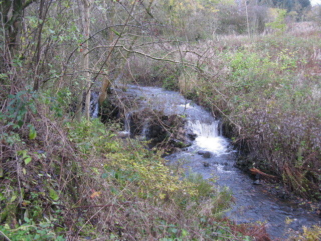
Shaw Linn is a picturesque freshwater oasis situated in the county of Renfrewshire, Scotland. This idyllic natural feature is a combination of a lake, pool, pond, and freshwater marsh, offering a diverse and thriving ecosystem.

The main body of Shaw Linn is a serene lake that stretches across a significant portion of the area. Its calm, crystal-clear waters are a haven for a variety of aquatic life, including fish, frogs, and waterfowl. The lake is surrounded by lush vegetation, such as reeds and water lilies, providing important habitats and nesting sites for numerous bird species.

Adjacent to the lake, there is a smaller pool that serves as a tranquil breeding ground for amphibians. Frogs and newts can be observed here during the spring and summer months, as they lay their eggs in the shallow water and rely on the surrounding vegetation for protection.

Shaw Linn also features a charming pond, which is known for its abundance of aquatic plants. This pond is teeming with life, with insects buzzing around the water's surface and dragonflies gracefully gliding through the air. It is a popular spot for birdwatchers, as many bird species can be spotted darting in and out of the reeds.

Lastly, the freshwater marsh at Shaw Linn offers a unique and important habitat for a variety of plant and animal species. This marshland is characterized by its wet and spongy ground, supporting a diverse range of vegetation, including sedges, rushes, and marsh marigolds. It serves as a breeding ground for insects and provides a source of food for birds and small mammals.

Overall, Shaw Linn is a remarkable natural feature that showcases the beauty and diversity of Scotland's freshwater ecosystems. It provides a sanctuary for a plethora of plant and animal species, making it a must-visit destination for nature enthusiasts and wildlife lovers alike.

If you have any feedback on the listing, please let us know in the comments section below.

Shaw Linn Images

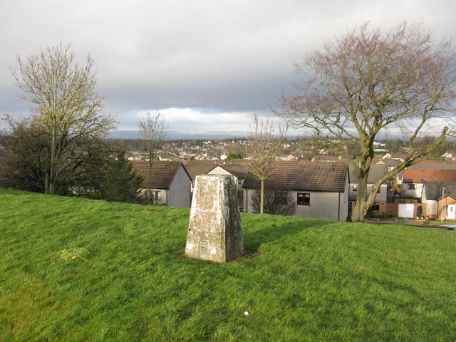
Images are sourced within 2km of 55.769675/-4.3268872 or Grid Reference NS5455. Thanks to Geograph Open Source API. All images are credited.

The Avenue Shopping Centre Newton Mearns
West Titwood Near Newton Mearns.
West Titwood
Near Newton Mearns.
Newton Mearns Baptist Church
Fields along Keltie Bridge
The Avenue Shopping Centre
Small Woods off Rodgers Avenue
Play area, Meadow Rise
Motorway traffic Looking south along the M77 near Newton Mearns.
Motorway traffic
Looking south along the M77 near Newton Mearns.
Mearns Castle High School Mearns Castle High School is a secondary school situated on Waterfoot Road in Newton Mearns.
Mearns Castle High School
Mearns Castle High School is a secondary school situated on Waterfoot Road in Newton Mearns.
Mearns Castle Trig Point The trig point is situated beside Mearns Castle High School and from here there is a good view over Newton Mearns towards the Campsie Fells in the distance.
Mearns Castle Trig Point
The trig point is situated beside Mearns Castle High School and from here there is a good view over Newton Mearns towards the Campsie Fells in the distance.
Broom Parish Church of Scotland In Newton Mearns at the corner of Mearns Road and Broom Road East.
Broom Parish Church of Scotland
In Newton Mearns at the corner of Mearns Road and Broom Road East.
A726 looking east
A726 looking east
A726 at Mearns Road overbridge
A726 passes under Titwood Road
Lloyds TSB Scotland Bank on Ayr Road, Newton Mearns [A77].
Lloyds TSB Scotland
Bank on Ayr Road, Newton Mearns [A77].
Whitecraigs Golf Club The southern end of the golf course viewed from Fruin avenue.
Whitecraigs Golf Club
The southern end of the golf course viewed from Fruin avenue.
Waterfall on Capelrig Burn In a small woodland area just off Crookfur Road, Newton Mearns.
Waterfall on Capelrig Burn
In a small woodland area just off Crookfur Road, Newton Mearns.
M77 Motorway Bridge On Netherplace road just outside Newton Mearns.
M77 Motorway Bridge
On Netherplace road just outside Newton Mearns.
Show me another place!

Shaw Linn is located at Grid Ref: NS5455 (Lat: 55.769675, Lng: -4.3268872)

Unitary Authority: East Renfrewshire

Police Authority: Greater Glasgow

What 3 Words

///spicy.unit.bucked. Near Newton Mearns, East Renfrewshire

Nearby Locations

Shaw Linn Mearns Burnhouse

Related Wikis

Glasgow Reform Synagogue

Glasgow Reform Synagogue is a synagogue in Newton Mearns, East Renfrewshire, Scotland. It is a member of the Movement for Reform Judaism and is the only...

Newton Mearns

Newton Mearns (Scots: The Mearns; Scottish Gaelic: Baile Ùr na Maoirne [ˈpalə ˈuːɾ nə ˈmɯːrˠɲə]) is a suburban town and the largest settlement in East...

Mearns Castle High School

Mearns Castle High School is a secondary school situated on Waterfoot Road in Newton Mearns, East Renfrewshire, Scotland roughly seven miles from Glasgow...
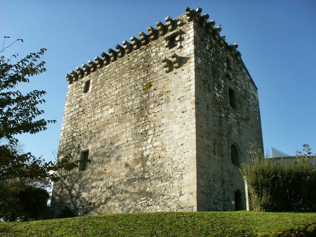
Mearns Castle

Mearns Castle is a 15th-century tower house in Newton Mearns, East Renfrewshire, south of Glasgow, Scotland. It is a Category A listed building. The castle...
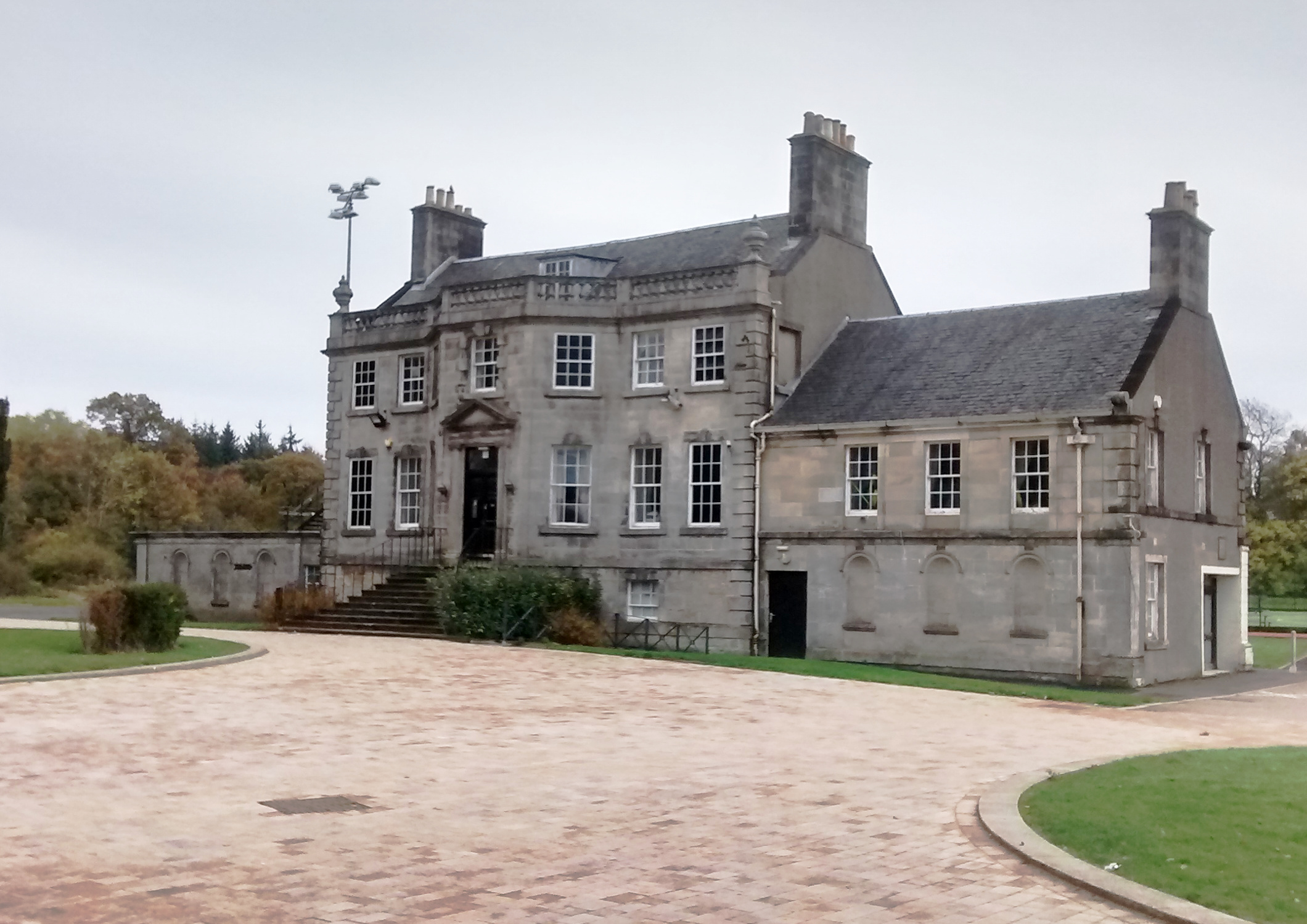
Capelrig House

Capelrig House is an 18th-century house in Newton Mearns, East Renfrewshire, Scotland, upon whose lands is situated Eastwood High School. The house is...

Eastwood High School, Newton Mearns

Eastwood High School is a comprehensive, non-denominational school located centrally in East Renfrewshire to the south of Glasgow, Scotland. It is one...

Netherplace

Netherplace is a hamlet in East Renfrewshire. It is to the west of Newton Mearns, and adjacent to the M77 motorway. The settlement is almost entirely along...

Whitecraigs RFC

Whitecraigs Rugby Football Club is a rugby union club based in Newton Mearns, East Renfrewshire, Scotland. The team competes in Scottish National League...

Related Videos

Walking With Joe

27 October 2018.

New Travel Bucket bag reveal by Morgan Grays

Hello Hello, Welcome to my latest bag, a classic blue and cream travel bag made by Morgan Grays. It is made of this creamy soft ...

Louis Vuitton Spirit of Travel book unboxing, Christmas animation

Hello Hello, Welcome to the unboxing of my last Louis Vuitton purchase of 2019, I am still loving the Christmas animation graphic.

Colin Shaw Travel Counsellors

Design Your Dream Holiday.

Nearby Amenities

Located within 500m of 55.769675,-4.3268872
Traffic Signals
Lat/Long: 55.7684287/-4.3215271
Bus Stop
Naptan AtcoCode: 6120176
Naptan NaptanCode: 37323458
Source: survey
Lat/Long: 55.772433/-4.3323521
Bus Stop
Naptan AtcoCode: 6120177
Naptan NaptanCode: 37324234
Source: survey
Lat/Long: 55.772513/-4.3327828
Barrier: entrance
Lat/Long: 55.7669678/-4.3249813
Crossing
Crossing: traffic_signals
Lat/Long: 55.7721111/-4.3335085
Bank
TSB
Addr Housenumber: 238
Addr Street: Ayr Road
Atm: yes
Brand: TSB
Brand Wikidata: Q7671560
Brand Wikipedia: en:TSB Bank (United Kingdom)
Phone: +44 141 397 9986
Lat/Long: 55.7727746/-4.3325499
Mearns Cross Barber
Addr Housenumber: 236
Addr Street: Ayr Road
Shop: hairdresser
Lat/Long: 55.7727964/-4.3323591
Fast Food
Valentini's Fast Food Pizzeria
Addr Housenumber: 234
Addr Postcode: G77 6AA
Addr Street: Ayr Road
Cuisine: pizza
Fhrs Id: 7649
Source Addr Postcode: FHRS Open Data
Lat/Long: 55.7728126/-4.3323215
Fast Food
The Mearns Wok
Addr Housenumber: 232
Addr Postcode: G77 6AA
Addr Street: Ayr Road
Cuisine: thai
Fhrs Id: 7653
Source Addr Postcode: FHRS Open Data
Lat/Long: 55.7728258/-4.332284
Fast Food
3 in 1 Plus
Addr Housenumber: 232A
Addr Postcode: G77 6AA
Addr Street: Ayr Road
Cuisine: indian
Fhrs Id: 812192
Source Addr: FHRS Open Data
Lat/Long: 55.7728421/-4.332239
Fast Food
Golden Kitchen
Addr Housenumber: 230
Addr Postcode: G77 6AA
Addr Street: Ayr Road
Cuisine: chinese
Fhrs Id: 7635
Source Addr Postcode: FHRS Open Data
Lat/Long: 55.772859/-4.3321934
Crossing
Crossing: traffic_signals
Lat/Long: 55.768322/-4.3216208
Paidmyre
Is In: Newton Mearns
Place: suburb
Lat/Long: 55.7693703/-4.3333075
Mearns
Is In: Newton Mearns
Place: suburb
Lat/Long: 55.767094/-4.322215
Generator Method: photovoltaic
Generator Output Electricity: yes
Generator Source: solar
Generator Type: solar_photovoltaic_panel
Location: roof
Power: generator
Lat/Long: 55.7704784/-4.3322457
Generator Method: photovoltaic
Generator Output Electricity: yes
Generator Source: solar
Generator Type: solar_photovoltaic_panel
Location: roof
Power: generator
Lat/Long: 55.7697463/-4.3282834
Generator Method: photovoltaic
Generator Output Electricity: yes
Generator Source: solar
Generator Type: solar_photovoltaic_panel
Location: roof
Power: generator
Lat/Long: 55.767468/-4.3288574
Generator Method: photovoltaic
Generator Output Electricity: yes
Generator Source: solar
Generator Type: solar_photovoltaic_panel
Location: roof
Power: generator
Lat/Long: 55.7658104/-4.326049
Generator Method: photovoltaic
Generator Output Electricity: yes
Generator Source: solar
Generator Type: solar_photovoltaic_panel
Location: roof
Power: generator
Lat/Long: 55.7701326/-4.3246973
Generator Method: photovoltaic
Generator Output Electricity: yes
Generator Source: solar
Generator Type: solar_photovoltaic_panel
Location: roof
Power: generator
Lat/Long: 55.7701642/-4.3246356
Generator Method: photovoltaic
Generator Output Electricity: yes
Generator Source: solar
Generator Type: solar_photovoltaic_panel
Location: roof
Power: generator
Lat/Long: 55.7701612/-4.321653
Generator Method: photovoltaic
Generator Output Electricity: yes
Generator Source: solar
Generator Type: solar_photovoltaic_panel
Location: roof
Power: generator
Lat/Long: 55.7702095/-4.3216315
Generator Method: photovoltaic
Generator Output Electricity: yes
Generator Source: solar
Generator Type: solar_photovoltaic_panel
Location: roof
Power: generator
Lat/Long: 55.769259/-4.319424
Post Box
Brand: Royal Mail
Brand Wikidata: Q638098
Mapillary: 377989663573553
Operator: Royal Mail
Operator Wikidata: Q638098
Post Box Type: pillar
Survey Date: 2021-04-12
Lat/Long: 55.7737213/-4.327893
Crossing
Crossing: traffic_signals
Lat/Long: 55.7684205/-4.3214161
Crossing
Crossing: traffic_signals
Lat/Long: 55.7685142/-4.3214514
Bus Stop
Bus: yes
Public Transport: platform
Lat/Long: 55.7679666/-4.3217678
The data included in this document is from www.openstreetmap.org. The data is made available under ODbL.

Have you been to Shaw Linn?

Leave your review of Shaw Linn below (or comments, questions and feedback).