Gittisham

Settlement in Devon East Devon

England

Gittisham

The Deer Park Hotel A specialist wedding venue - very good it is too!
The Deer Park Hotel Credit: Jonathan Billinger

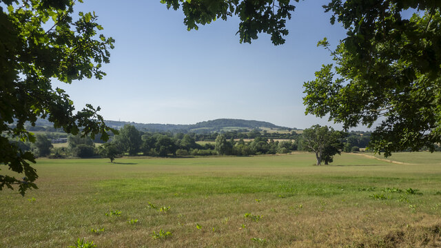
Gittisham is a small village located in the county of Devon, England. It is situated about three miles northeast of the market town of Honiton and lies within the East Devon District. The village is nestled in the picturesque Otter Valley, surrounded by rolling hills and lush green countryside, providing residents and visitors with a tranquil and idyllic setting.

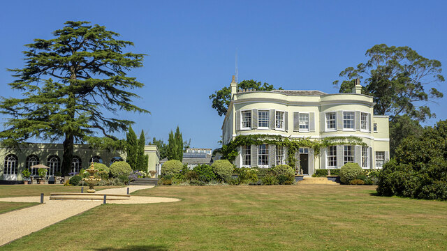
Gittisham has a long and rich history, with evidence of human habitation in the area dating back to the Neolithic period. The village itself has a charming and traditional character, with many of its buildings constructed from the local honey-colored stone, giving it a distinct architectural charm.

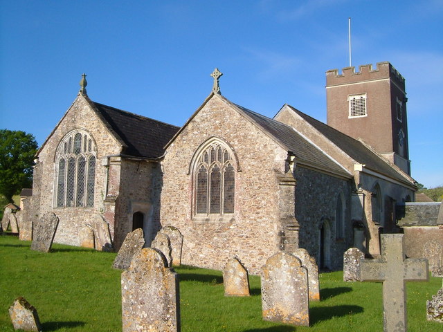
Despite its small size, Gittisham boasts a strong sense of community, with a village hall serving as a hub for various social activities and events. The village also has a picturesque 14th-century parish church, St. Michael and All Angels, which adds to the historical charm of the area.

For outdoor enthusiasts, Gittisham offers a range of opportunities to explore the surrounding countryside. The village is located close to the East Devon Area of Outstanding Natural Beauty, which features stunning landscapes, walking trails, and wildlife-rich habitats.

While Gittisham may be a tranquil and peaceful village, it benefits from its close proximity to larger towns and cities. The nearby town of Honiton provides residents with essential amenities, including shops, schools, and healthcare facilities.

Overall, Gittisham is a charming and historic village that offers a peaceful and picturesque place to live or visit, with its beautiful countryside, strong sense of community, and convenient access to nearby towns and cities.

If you have any feedback on the listing, please let us know in the comments section below.

Gittisham Images

Images are sourced within 2km of 50.778849/-3.229874 or Grid Reference SY1398. Thanks to Geograph Open Source API. All images are credited.

The Deer Park Hotel A specialist wedding venue - very good it is too!
The Deer Park Hotel
A specialist wedding venue - very good it is too!
View across the Otter valley Westgate Hill in the distance, viewed from the grounds of The Deer Park Hotel.
View across the Otter valley
Westgate Hill in the distance, viewed from the grounds of The Deer Park Hotel.
Water Lily pond One of the features of the walled garden at The Deer Park Hotel.
Water Lily pond
One of the features of the walled garden at The Deer Park Hotel.
Sunflower and Bumble Bee Within the sun-trap that is the walled garden at The Deer Park Hotel.
Sunflower and Bumble Bee
Within the sun-trap that is the walled garden at The Deer Park Hotel.
Otter Inn in Weston A view of the front of the Otter Inn in Weston, near Honiton, Devon. The Inn is next to the River Otter and close to the A30.
Otter Inn in Weston
A view of the front of the Otter Inn in Weston, near Honiton, Devon. The Inn is next to the River Otter and close to the A30.
Otter Inn Sign in Weston A view of the Otter Inn Sign in Weston, near Honiton, Devon. The Inn is next to the River Otter and close to the A30.
Otter Inn Sign in Weston
A view of the Otter Inn Sign in Weston, near Honiton, Devon. The Inn is next to the River Otter and close to the A30.
Bridge over the River A bridge over the River Otter carrying the minor road between Honiton and Weston, in Devon, as seen from the Otter Inn car park in Weston.
Bridge over the River
A bridge over the River Otter carrying the minor road between Honiton and Weston, in Devon, as seen from the Otter Inn car park in Weston.
On the A30 heading east, approaching the Honiton turning
Footpath to Buckerell Off the old Exeter road. The metal barrier is designed to keep ' unwanted ' visitors to the field.
Footpath to Buckerell
Off the old Exeter road. The metal barrier is designed to keep ' unwanted ' visitors to the field.
Access to Colhayes farm Off the old Exeter road. Formerly the A30.
Access to Colhayes farm
Off the old Exeter road. Formerly the A30.
Approaching Fenny Bridges from the East The bridge crosses the River Otter at this point.
This at one point was the main route into Exeter from Honiton. The A30.
It is now much quieter due to the nearby by-pass.
Approaching Fenny Bridges from the East
The bridge crosses the River Otter at this point. This at one point was the main route into Exeter from Honiton. The A30. It is now much quieter due to the nearby by-pass.
 River Otter at Fenny Bridges Looking North. The main London to Exeter railway bridge can be seen in the background. Just out of sight is the new A30 Honiton by-pass.
River Otter at Fenny Bridges
Looking North. The main London to Exeter railway bridge can be seen in the background. Just out of sight is the new A30 Honiton by-pass.
You'll need a head for heights A Vodaphone team perform maintenance on their mast at Fenny Bridges.
You'll need a head for heights
A Vodaphone team perform maintenance on their mast at Fenny Bridges.
An OS Bench Mark Situated on the wall of Rock Farm.
An OS Bench Mark
Situated on the wall of Rock Farm.
Warning sign, cars and buildings on the old A30, heading west
Farmland looking north from the old A30
Gittisham, St. Michael's Church: Northern aspect
Gittisham, St. Michael's Church: The nave
Show me another place!

Gittisham is located at Grid Ref: SY1398 (Lat: 50.778849, Lng: -3.229874)

Administrative County: Devon

District: East Devon

Police Authority: Devon and Cornwall

What 3 Words

///limped.topics.herring. Near Honiton, Devon

Related Wikis

Gittisham

Gittisham is a village and civil parish in East Devon, Devon, England, near Honiton. The village is 3 miles (5 km) from Ottery St Mary and it has a church...

Pomeroy Wood

Pomeroy Wood is the site near Honiton in Devon of a Roman military site of unknown type, probably either a fort or marching camp, though archaeological...

Deer Park Country House, Buckerell

Deer Park Country House near Honiton, Devon is a house of historical significance and is Grade II listed on the English Heritage Register. It was built...

St James and St Anne's Church, Alfington

St James' and St Anne's Church is a Church of England church in Alfington, Devon, England. It was built in 1849 at the expense of Sir John Taylor Coleridge...

Nearby Amenities

Located within 500m of 50.778849,-3.229874
Gittisham
Place: village
Lat/Long: 50.7788768/-3.2290973
Post Box
Post Box Type: lamp
Royal Cypher: EIIR
Royal Cypher Wikidata: Q33102113
Lat/Long: 50.7786345/-3.2287815
Power: pole
Lat/Long: 50.7782045/-3.2366592
Power: pole
Lat/Long: 50.7802956/-3.2349882
Power: pole
Lat/Long: 50.7811317/-3.2339019
Power: pole
Lat/Long: 50.7820712/-3.232652
Power: pole
Lat/Long: 50.7823646/-3.2313564
Power: pole
Lat/Long: 50.7831939/-3.2308146
Power: pole
Lat/Long: 50.7830413/-3.2313913
Power: pole
Lat/Long: 50.7826699/-3.2322577
Power: pole
Lat/Long: 50.7812759/-3.2340091
Power: pole
Lat/Long: 50.7805127/-3.2350391
Power: pole
Lat/Long: 50.779702/-3.2360637
Advertising: board
Lat/Long: 50.7787391/-3.2284327
Telephone
Defibrillator
Booth: K6
Covered: booth
Defibrillator Location: inside old red phone box, Gittisham
Emergency: defibrillator
Listed Status: Grade II
Man Made: telephone_box
Lat/Long: 50.7788179/-3.2289712
Gittisham
Bus: yes
Public Transport: stop_position
Lat/Long: 50.7787998/-3.2291617
Gittisham (W-bound)
Public Transport: platform
Lat/Long: 50.7787701/-3.229145
Gittisham (E-bound)
Bench: yes
Public Transport: platform
Shelter: yes
Lat/Long: 50.7788286/-3.2291476
The data included in this document is from www.openstreetmap.org. The data is made available under ODbL.

Have you been to Gittisham?

Leave your review of Gittisham below (or comments, questions and feedback).