Loch Greòtair

Lake, Pool, Pond, Freshwater Marsh in Ross-shire

Scotland

Loch Greòtair

Great Bernera bridges The new bridge under construction and the old white bridge.
Great Bernera bridges Credit: Catherine Morgan

Loch Greòtair is a picturesque freshwater loch located in Ross-shire, Scotland. Covering an area of approximately 50 acres, this tranquil body of water offers breathtaking views and a diverse ecosystem that attracts nature enthusiasts from far and wide.

Surrounded by rolling hills and dense woodland, Loch Greòtair is known for its crystal-clear waters and abundant wildlife. The loch serves as a vital habitat for a variety of bird species, including great crested grebes, mallards, tufted ducks, and swans, making it a popular spot for birdwatchers. The surrounding marshland also provides a home for numerous amphibians, such as frogs and newts.

The loch itself is relatively shallow, with an average depth of around 10 feet. It is fed by several small streams that flow down from the nearby hills, ensuring a constant supply of freshwater. The water in Loch Greòtair is incredibly clean and unpolluted, making it an ideal environment for various fish species, including brown trout, pike, and perch. As a result, the loch is a popular destination for anglers seeking a peaceful day of fishing.

For visitors looking to explore the area, there are several walking trails that wind their way around the loch, offering breathtaking views of the surrounding landscape. Additionally, there are designated picnic areas and benches where visitors can relax and enjoy the serene atmosphere.

Overall, Loch Greòtair is a hidden gem in the heart of Ross-shire, offering a peaceful retreat for nature lovers and outdoor enthusiasts alike. Its stunning scenery, diverse wildlife, and tranquil ambiance make it a must-visit destination for those seeking a true Scottish experience.

If you have any feedback on the listing, please let us know in the comments section below.

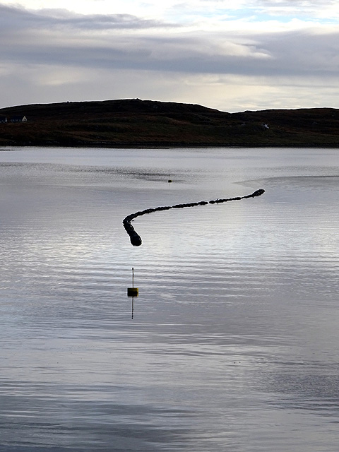
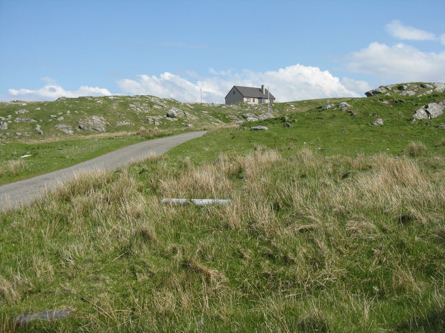
Loch Greòtair Images

Images are sourced within 2km of 58.192802/-6.804469 or Grid Reference NB1732. Thanks to Geograph Open Source API. All images are credited.

Great Bernera bridges The new bridge under construction and the old white bridge.
Great Bernera bridges
The new bridge under construction and the old white bridge.
"The Bridge Across the Atlantic" Bernera Bridge is one of several bridges which claim to span the Atlantic Ocean. This one connects the Lewis mainland with the island of Great Bernera / Bearnaraigh. Note the standing stones on the far side of the bridge.
<span class="nowrap"><a title="http://www.uigandbernera.com/" rel="nofollow ugc noopener" href="http://www.uigandbernera.com/">Link</a><img style="margin-left:2px;" alt="External link" title="External link - shift click to open in new window" src="https://s1.geograph.org.uk/img/external.png" width="10" height="10"/></span>
"The Bridge Across the Atlantic"
Bernera Bridge is one of several bridges which claim to span the Atlantic Ocean. This one connects the Lewis mainland with the island of Great Bernera / Bearnaraigh. Note the standing stones on the far side of the bridge. LinkExternal link
Bernera Bridge Opened in 1953 and connecting Lewis with Great Bernera / Bearnaraigh.
<span class="nowrap"><a title="http://www.uigandbernera.com/" rel="nofollow ugc noopener" href="http://www.uigandbernera.com/">Link</a><img style="margin-left:2px;" alt="External link" title="External link - shift click to open in new window" src="https://s1.geograph.org.uk/img/external.png" width="10" height="10"/></span>
Bernera Bridge
Opened in 1953 and connecting Lewis with Great Bernera / Bearnaraigh. LinkExternal link
Sea Kayakers by Port a Chruidh Kayakers who have come from Miavaig / Miabhaig and are heading eastwards, having just passed below Bernera Bridge. The mainland of Lewis is on the far side of the 1953 bridge.
<span class="nowrap"><a title="http://www.uigandbernera.com/" rel="nofollow ugc noopener" href="http://www.uigandbernera.com/">Link</a><img style="margin-left:2px;" alt="External link" title="External link - shift click to open in new window" src="https://s1.geograph.org.uk/img/external.png" width="10" height="10"/></span>
Sea Kayakers by Port a Chruidh
Kayakers who have come from Miavaig / Miabhaig and are heading eastwards, having just passed below Bernera Bridge. The mainland of Lewis is on the far side of the 1953 bridge. LinkExternal link
Telephone Box at Crulabhig Probably it's only the sheep that get calls here?
Telephone Box at Crulabhig
Probably it's only the sheep that get calls here?
Bernera Bridge
Bernera Bridge
Crulivig: the telephone box Pictured during heavy rain, this phone box has Hebridean doors, to keep the wind at bay.
Crulivig: the telephone box
Pictured during heavy rain, this phone box has Hebridean doors, to keep the wind at bay.
Crulivig: postbox № HS2 91 This postbox stands on the opposite side of the road to <a href="https://www.geograph.org.uk/photo/3286743">NB1733 : Crulivig: the telephone box</a>. It is emptied each morning except Sunday at a quarter to nine.
Crulivig: postbox № HS2 91
This postbox stands on the opposite side of the road to NB1733 : Crulivig: the telephone box. It is emptied each morning except Sunday at a quarter to nine.
Great Bernera Road Bridge Great Bernera lies in Loch Roag on the north-west coast of Lewis and is linked to it by a road bridge. Built in 1953, the bridge was the first pre-stressed concrete bridge in Europe. The main settlement on the island is Breaclete (Gaelic: Breacleit).
I was here bagging the island of Great Bernera with George Morl and its high point a TuMP called Middle Shalaval, at 87 metres and a P87 hill.
Great Bernera Road Bridge
Great Bernera lies in Loch Roag on the north-west coast of Lewis and is linked to it by a road bridge. Built in 1953, the bridge was the first pre-stressed concrete bridge in Europe. The main settlement on the island is Breaclete (Gaelic: Breacleit). I was here bagging the island of Great Bernera with George Morl and its high point a TuMP called Middle Shalaval, at 87 metres and a P87 hill.
Abandoned croft house near Lundal
Great Bernera Road Bridge The road south hugged the shore in 1975. Now it blasts straight ahead.
Great Bernera Road Bridge
The road south hugged the shore in 1975. Now it blasts straight ahead.
Tursachan standing stone and Bernera Road Bridge The stone is one of a group of three standing with a fourth being prostrate.
Tursachan standing stone and Bernera Road Bridge
The stone is one of a group of three standing with a fourth being prostrate.
A view over Loch Barraglom From Iarsiadar.
A view over Loch Barraglom
From Iarsiadar.
The Bernera Bridge The bridge was opened in 1953 and widened in 1998. Prior to that, Bernera was connected to the main island by ferry but during construction of the bridge, divers found the remains of a causeway, of unknown age.
The Bernera Bridge
The bridge was opened in 1953 and widened in 1998. Prior to that, Bernera was connected to the main island by ferry but during construction of the bridge, divers found the remains of a causeway, of unknown age.
The Bernera Bridge With the Barraglom standing stones in view. The bridge crosses Loch Barraglom, a sea loch which can be accessed from the Atlantic at both ends. Consequently, it could be said that this a bridge across the Atlantic Ocean.
The Bernera Bridge
With the Barraglom standing stones in view. The bridge crosses Loch Barraglom, a sea loch which can be accessed from the Atlantic at both ends. Consequently, it could be said that this a bridge across the Atlantic Ocean.
The Loch Barraglom Monster? Sadly not. They are lobster creels. Lobster fishing is an important contributor to the local economy.
The Loch Barraglom Monster?
Sadly not. They are lobster creels. Lobster fishing is an important contributor to the local economy.
Bernera Bridge Connecting Great Bernera/Beàrnaraigh to the Isle of Lewis, one of several 'Bridges over the Atlantic'
Bernera Bridge
Connecting Great Bernera/Beàrnaraigh to the Isle of Lewis, one of several 'Bridges over the Atlantic'
House at Iarsiadar Looking east from Àird Iarsiadar.
House at Iarsiadar
Looking east from Àird Iarsiadar.
Show me another place!

Loch Greòtair is located at Grid Ref: NB1732 (Lat: 58.192802, Lng: -6.804469)

Unitary Authority: Na h-Eileanan an Iar

Police Authority: Highlands and Islands

What 3 Words

///twist.licks.inherits. Near Carloway, Na h-Eileanan Siar

Related Wikis

Callanish VIII

The Callanish VIII stone setting is one of many megalithic structures around the better-known (and larger) Calanais I on the west coast of the Isle of...

Eilean Chearstaidh

Eilean Kearstay (Scottish Gaelic: Eilean Chearstaigh) is an uninhabited island in Loch Roag in the Outer Hebrides of Scotland. It lies south east of Great...

Ceabhaigh

Ceabhaigh is a small island in an arm of Loch Ròg on the west coast of Lewis in the Outer Hebrides of Scotland. It is about 25 hectares (62 acres) in extent...

Callanish Stones

The Callanish Stones (or "Callanish I": Scottish Gaelic: Clachan Chalanais or Tursachan Chalanais) are an arrangement of standing stones placed in a cruciform...

Nearby Amenities

Located within 500m of 58.192802,-6.804469
Power: pole
Lat/Long: 58.1914781/-6.7964845
Power: pole
Lat/Long: 58.191516/-6.7979719
Power: pole
Lat/Long: 58.1915995/-6.7984956
Power: pole
Lat/Long: 58.191942/-6.8001051
Power: pole
Lat/Long: 58.1921863/-6.8012664
Power: pole
Lat/Long: 58.1924915/-6.8020281
Power: pole
Lat/Long: 58.1930069/-6.8031624
Power: pole
Lat/Long: 58.1935295/-6.8044654
Power: pole
Lat/Long: 58.1938229/-6.8051981
Power: pole
Lat/Long: 58.1940185/-6.8057876
Power: pole
Lat/Long: 58.1943639/-6.8070427
Power: pole
Lat/Long: 58.1946256/-6.8079476
Power: pole
Lat/Long: 58.1951113/-6.8093129
Power: pole
Lat/Long: 58.1953754/-6.8104663
Man Made: mast
Lat/Long: 58.1932936/-6.8020057
The data included in this document is from www.openstreetmap.org. The data is made available under ODbL.

Have you been to Loch Greòtair?

Leave your review of Loch Greòtair below (or comments, questions and feedback).