Geldeston

Settlement in Norfolk South Norfolk

England

Geldeston

Wooded pond
Wooded pond Credit: N Chadwick

Geldeston is a picturesque village located in the county of Norfolk, England. Situated on the southern bank of the River Waveney, it falls within the South Norfolk district and lies approximately 4 miles west of the market town of Beccles. The village is surrounded by beautiful countryside and offers stunning views of the Waveney Valley.

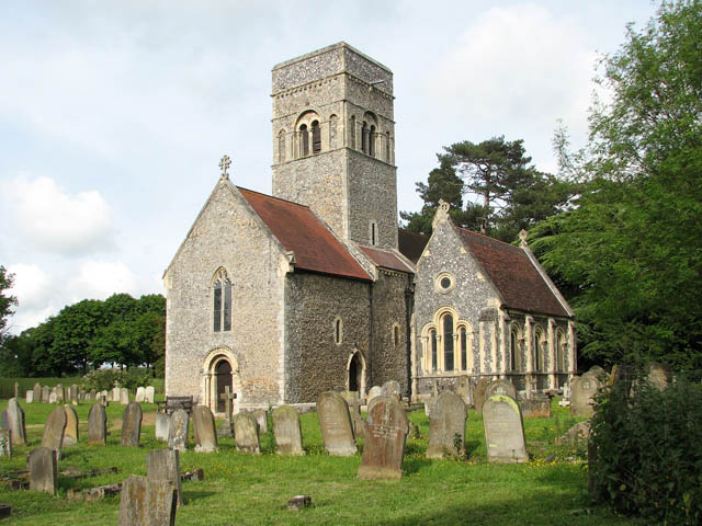
Geldeston has a rich history that dates back to the Domesday Book, where it is mentioned as "Geldestuna," indicating its ancient origins. The village is known for its charming traditional architecture, with many of its buildings constructed from local flint and brick. The Grade I listed St. Michael's Church, a medieval gem, is one of the prominent landmarks in Geldeston.

Despite its small size, the village boasts a thriving community and offers several amenities for residents and visitors alike. The Wherry Inn, a popular riverside pub, serves as a social hub and offers a selection of food and drink. Additionally, Geldeston is home to a village hall, a cricket pitch, and a playground, providing recreational opportunities for locals.

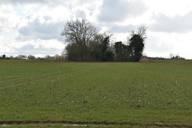
The surrounding countryside offers numerous opportunities for outdoor activities. The River Waveney is ideal for boating, fishing, and wildlife spotting, while the nearby Geldeston Locks provide a picturesque spot for leisurely walks and picnics. The village is also located near the Broads National Park, renowned for its scenic waterways and abundant wildlife.

In summary, Geldeston is a quaint village in Norfolk, boasting a rich history, beautiful architecture, and a close-knit community. Its idyllic location on the River Waveney and proximity to the Broads National Park make it an attractive destination for nature lovers and those seeking a peaceful retreat.

If you have any feedback on the listing, please let us know in the comments section below.

Geldeston Images

Images are sourced within 2km of 52.472566/1.521056 or Grid Reference TM3991. Thanks to Geograph Open Source API. All images are credited.

Wooded pond
Wooded pond
River Waveney
River Waveney
The Wherry Inn
The Wherry Inn
River Waveney
River Waveney
The Locks Inn
The Locks Inn
A143 east approaching junction with A146
The former railway line from the crossing Looking east from the Geldeston crossing.
The former railway line from the crossing
Looking east from the Geldeston crossing.
A single parapet of a former bridge across a tributary The rest of the bridge has been dismantled to benefit the passage of river-craft
A single parapet of a former bridge across a tributary
The rest of the bridge has been dismantled to benefit the passage of river-craft
The former station house at Geldeston The building is a private residence and has an extension on the west end, but retains the Italianate style of the Waveney Valley Railway buildings.
The former Goods Shed can be seen in the background which has been given a pent roof extension on its east end.
The station was 16½ miles from Tivetshall 2½ miles from Beccles. The platform was 110 yards long. A 200 yard long siding fed into the goods shed which contained a 1 ton crane for unloading and loading. The signal box stood to the north of the track by the crossing gates and a crossing keepers hut on the south side of the single track. The station was closed to all traffic in 1915 as a war economy measure but reopened in 1919. Passenger services were withdrawn in July 1954 but freight services continued until July 1964.
The former station house at Geldeston
The building is a private residence and has an extension on the west end, but retains the Italianate style of the Waveney Valley Railway buildings. The former Goods Shed can be seen in the background which has been given a pent roof extension on its east end. The station was 16½ miles from Tivetshall 2½ miles from Beccles. The platform was 110 yards long. A 200 yard long siding fed into the goods shed which contained a 1 ton crane for unloading and loading. The signal box stood to the north of the track by the crossing gates and a crossing keepers hut on the south side of the single track. The station was closed to all traffic in 1915 as a war economy measure but reopened in 1919. Passenger services were withdrawn in July 1954 but freight services continued until July 1964.
The former Goods Shed at Geldeston station A pent roof extension has been added to this end of the building. A railway line once ran through the building which had a large sliding door each end. Inside the goods were stored on a wooden deck at the same height as the floor of the wagons and a 1 ton crane facilitated unloading and loading the heavier items. A wire netting cage protected the sacks of grain and other perishable goods from vermin.
The former Goods Shed at Geldeston station
A pent roof extension has been added to this end of the building. A railway line once ran through the building which had a large sliding door each end. Inside the goods were stored on a wooden deck at the same height as the floor of the wagons and a 1 ton crane facilitated unloading and loading the heavier items. A wire netting cage protected the sacks of grain and other perishable goods from vermin.
Gate keeper's cottage on Braces Lane crossing The crossing, designated the number 84, is now a private dwelling house. The track crossed the road this side of the house. A small extension has been added to the east end but the building is much as it was in a much simplified Italianate style.
Gate keeper's cottage on Braces Lane crossing
The crossing, designated the number 84, is now a private dwelling house. The track crossed the road this side of the house. A small extension has been added to the east end but the building is much as it was in a much simplified Italianate style.
Site of the former level crossing #86 at Geldeston The five bar gate marks the line of the former railway. The signal box stood on this corner where the hedge is in the foreground.
Site of the former level crossing #86 at Geldeston
The five bar gate marks the line of the former railway. The signal box stood on this corner where the hedge is in the foreground.
Field near Shipmeadow A field to the north of Shipmeadow, off the footpath to The Locks Inn by the River Waveney.
Field near Shipmeadow
A field to the north of Shipmeadow, off the footpath to The Locks Inn by the River Waveney.
Kells Way, Geldeston One of several distinctive and thoughtful council housing projects by Herbert Tayler & David Green for Loddon District Council. Built 1947-51.
Kells Way, Geldeston
One of several distinctive and thoughtful council housing projects by Herbert Tayler & David Green for Loddon District Council. Built 1947-51.
Serpentine wall in Geldeston Street The curtain wall shields The Old House from the road.
Unusually the wall is buttressed and continues at right-angles for a few yards close to the viewer
Serpentine wall in Geldeston Street
The curtain wall shields The Old House from the road. Unusually the wall is buttressed and continues at right-angles for a few yards close to the viewer
River Waveney The River Waveney forms the boundary between Suffolk and Norfolk. It rises at Redgrave Fen and flows in an easterly direction though the towns of Diss, Bungay (the head of navigation) and Beccles. There is a weir at Billingford, shortly after the River Dove, flowing northwards from Eye, joins the Waveney on the southern bank. The Waveney passes round Bungay and on to Beccles. Having skirted past Oulton Broad it passes through Somerleyton and Hadiscoe before merging with the Yare in Breydon Water.
River Waveney
The River Waveney forms the boundary between Suffolk and Norfolk. It rises at Redgrave Fen and flows in an easterly direction though the towns of Diss, Bungay (the head of navigation) and Beccles. There is a weir at Billingford, shortly after the River Dove, flowing northwards from Eye, joins the Waveney on the southern bank. The Waveney passes round Bungay and on to Beccles. Having skirted past Oulton Broad it passes through Somerleyton and Hadiscoe before merging with the Yare in Breydon Water.
Pylon by River Waveney
Show me another place!

Geldeston is located at Grid Ref: TM3991 (Lat: 52.472566, Lng: 1.521056)

Administrative County: Norfolk

District: South Norfolk

Police Authority: Norfolk

What 3 Words

///spike.trickles.recapture. Near Beccles, Suffolk

Related Wikis

Geldeston Meadows

Geldeston Meadows is a 14-hectare (35-acre) biological Site of Special Scientific Interest near Geldeston in Norfolk. It is part of the Broadland Ramsar...

Geldeston

Geldeston is a village and civil parish in the English county of Norfolk. The village is located 2.5 miles (4.0 km) north-west of Beccles and 14 miles...

Geldeston railway station

Geldeston (also Geldeston Halt) was a station on the Waveney Valley Line serving the village of Geldeston, Norfolk. It was operational for passenger services...

Leet Hill, Kirby Cane

Leet Hill, Kirby Cane is a 6.5-hectare (16-acre) geological Site of Special Scientific Interest in Kirby Cane in Norfolk. It is a Geological Conservation...

Haughey Air AgustaWestland AW139 crash

On 13 March 2014, an AgustaWestland AW139 helicopter of Haughey Air crashed shortly after taking off at night in fog from Gillingham, Norfolk, United Kingdom...

Gillingham, Norfolk

Gillingham ( GHIL-ing-əm) is a small village and civil parish in the English county of Norfolk. The villages is located 1.5 miles (2.4 km) north-west...

Stockton, Norfolk

Stockton is a small village in Norfolk, England near the A146, just over 2 miles from Beccles. It covers an area of 3.65 km2 (1.41 sq mi) and had a population...
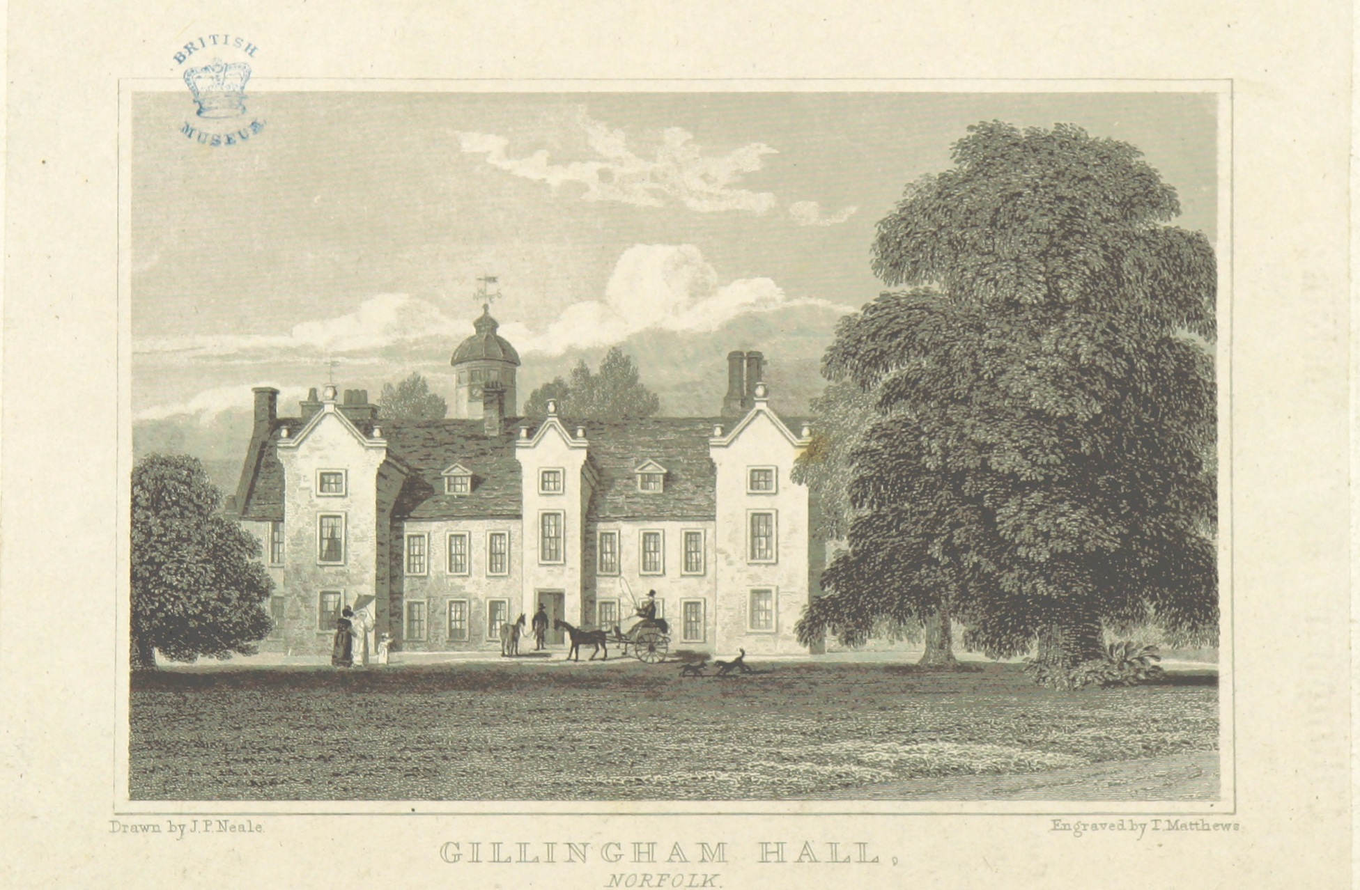
Gillingham Hall

Gillingham Hall is a Jacobean manor house in the village of Gillingham, Norfolk, England. It is a Grade II* Listed Building.The house has 10-bedrooms and...

Nearby Amenities

Located within 500m of 52.472566,1.521056
Defibrillator
Access: yes
Booth: K6
Covered: booth
Defibrillator Location: Inside old red phone box by entrance to Geldeston Village Hall
Disused Amenity: telephone
Emergency: defibrillator
Indoor: no
Man Made: telephone_box
Ref GB The Circuit: 356631F6-7BB9-4176-99AF-AE220147E058
Lat/Long: 52.4724307/1.5165715
Post Box
Collection Times: Mo-Fr 16:30; Sa 10:15
Operator: Royal Mail
Post Box Mounting: wall
Post Box Type: lamp
Ref: NR34 3425
Royal Cypher: EIIR
Royal Cypher Wikidata: Q33102113
Lat/Long: 52.4723975/1.5165811
Barrier: kissing_gate
Bicycle: no
Foot: yes
Lat/Long: 52.4759023/1.525707
Crossing: informal
Lat/Long: 52.4759578/1.5257509
Bus Stop
Wherry, adj
Bench: yes
Naptan AtcoCode: 2900G051
Naptan Bearing: E
Naptan CommonName: Wherry
Naptan Indicator: adj
Naptan Landmark: public house
Naptan Locality: Geldeston
Naptan NaptanCode: nfoatagw
Naptan ShortCommonName: Wherry
Naptan Street: The Street
Naptan Verified: no
Shelter: yes
Source: naptan_import
Lat/Long: 52.4725189/1.5163918
Bus Stop
Wherry, opp
Bench: no
Naptan AtcoCode: 2900G052
Naptan Bearing: W
Naptan CommonName: Wherry
Naptan Indicator: opp
Naptan Landmark: village hall
Naptan Locality: Geldeston
Naptan NaptanCode: nfoataja
Naptan Street: The Street
Naptan Verified: no
Shelter: no
Source: naptan_import
Lat/Long: 52.4724375/1.5166621
Give Way
Lat/Long: 52.4758658/1.521925
Crossing
Crossing: unmarked
Crossing Island: no
Kerb: no
Tactile Paving: no
Lat/Long: 52.4746451/1.5213799
Geldeston
Place: village
Wikidata: Q3290857
Wikipedia: en:Geldeston
Lat/Long: 52.4721469/1.5191655
Give Way
Lat/Long: 52.4759015/1.5220495
Entrance: main
Lat/Long: 52.4758508/1.524799
Power: pole
Lat/Long: 52.4757729/1.5216199
Power: pole
Lat/Long: 52.4745631/1.5223816
Power: pole
Lat/Long: 52.4752003/1.5219498
Power: pole
Lat/Long: 52.4766641/1.5212551
Power: pole
Lat/Long: 52.4761201/1.521408
Waste Basket
Lat/Long: 52.4726426/1.5159899
Bench
Backrest: yes
Colour: red
Material: wood
Seats: 3
Lat/Long: 52.472681/1.5157613
Geldeston
Inscription: Presented by Geldeston & Stockton Womens Institute / 1972
Man Made: village_sign
Material: wood
Start Date: 1972
Lat/Long: 52.4726726/1.5157958
Give Way
Lat/Long: 52.4724356/1.5180013
Give Way
Lat/Long: 52.47244/1.5164655
Power: pole
Lat/Long: 52.4724653/1.5250772
Power: pole
Lat/Long: 52.4715994/1.5251684
Power: pole
Lat/Long: 52.4707497/1.5251845
Power: pole
Lat/Long: 52.4706403/1.5181142
Power: pole
Lat/Long: 52.4704409/1.5198818
Power: pole
Lat/Long: 52.4702563/1.521644
Power: pole
Lat/Long: 52.4700635/1.5234169
Power: pole
Lat/Long: 52.4698854/1.5252194
Barrier: kissing_gate
Bicycle: no
Foot: yes
Lat/Long: 52.4745955/1.5249969
Millennium Milepost Geldeston
Description: 1) Beccles 3 2) Loddon 7.5, Norwich 24
Image: https://www.cyclestreets.net/location/186513/cyclestreets186513-size640.jpg
Information: guidepost
Ncn Milepost: mills
Sustrans Ref: MP 550
Tourism: information
Lat/Long: 52.4725326/1.5162954
Historic: memorial
Inscription: Geldeston 2000
Memorial: stone
Lat/Long: 52.4726569/1.5155373
Covered: no
Leisure: picnic_table
Lat/Long: 52.4726789/1.5158799
Crossing
Crossing: unmarked
Crossing Island: no
Kerb: raised
Tactile Paving: yes
Lat/Long: 52.4728599/1.5144709
Waste Basket
Colour: green
Waste: trash
Lat/Long: 52.4730539/1.5144885
Bench
Backrest: yes
Material: wood
Seats: 3
Lat/Long: 52.4730433/1.5145314
Give Way
Lat/Long: 52.4728983/1.5146154
Give Way
Lat/Long: 52.4729367/1.5145408
Waste Basket
Colour: blue
Waste: trash
Lat/Long: 52.4725237/1.5161515
Recycling
Colour: red
Location: overground
Recycling Glass: no
Recycling Glass Bottles: yes
Recycling Type: container
Lat/Long: 52.4725139/1.5161408
Waste Basket
Colour: red
Inscription: Dog waste only
Waste: dog_excrement
Lat/Long: 52.4724028/1.5164519
Waste Basket
Waste: trash
Lat/Long: 52.4724102/1.5164405
Village Hall
Board Type: notice
Information: board
Tourism: information
Lat/Long: 52.4724277/1.5168157
Parish Council
Board Type: notice
Information: board
Tourism: information
Lat/Long: 52.4724294/1.516877
Traffic Mirror
Lat/Long: 52.4725764/1.5209091
Give Way
Lat/Long: 52.4726393/1.5210114
Post Box
Collection Times: Mo-Fr 09:00; Sa 07:00
Operator: Royal Mail
Post Box Mounting: wall
Post Box Type: wall
Ref: NR34 3414D
Royal Cypher: VR
Royal Cypher Wikidata: Q33102356
Lat/Long: 52.4729386/1.5255507
Waste Basket
Lat/Long: 52.4759514/1.5257679
The data included in this document is from www.openstreetmap.org. The data is made available under ODbL.

Have you been to Geldeston?

Leave your review of Geldeston below (or comments, questions and feedback).