Maatruf

Coastal Feature, Headland, Point in Shetland

Scotland

Maatruf

Southern slopes of the Ward of Bressay Looking just east of south, with Bard Head on the left.
Southern slopes of the Ward of Bressay Credit: David Purchase

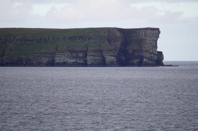
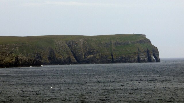
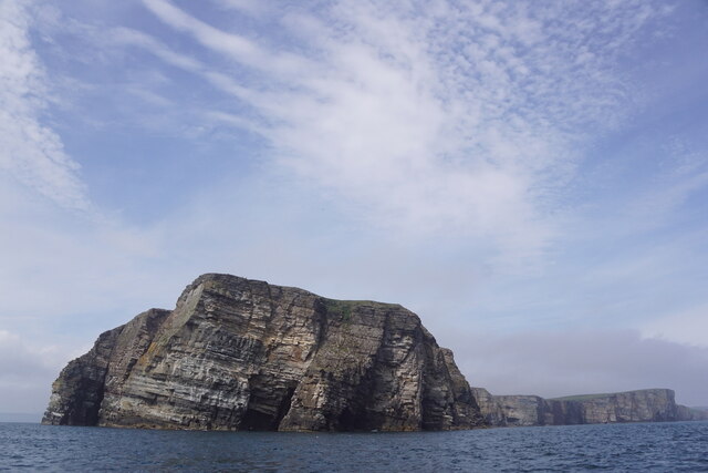
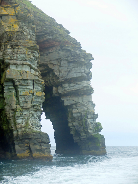
Maatruf is a prominent coastal feature located in the Shetland Islands, an archipelago in northern Scotland. It is a headland that extends into the North Sea, forming a distinct point along the rugged coastline. The name "Maatruf" is derived from the Old Norse language, reflecting the region's Viking heritage.

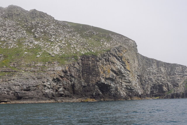
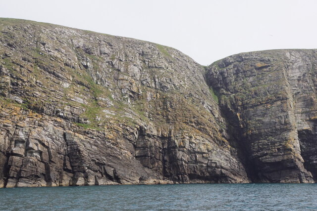
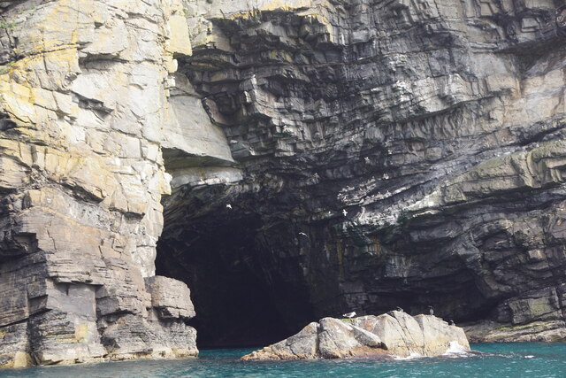
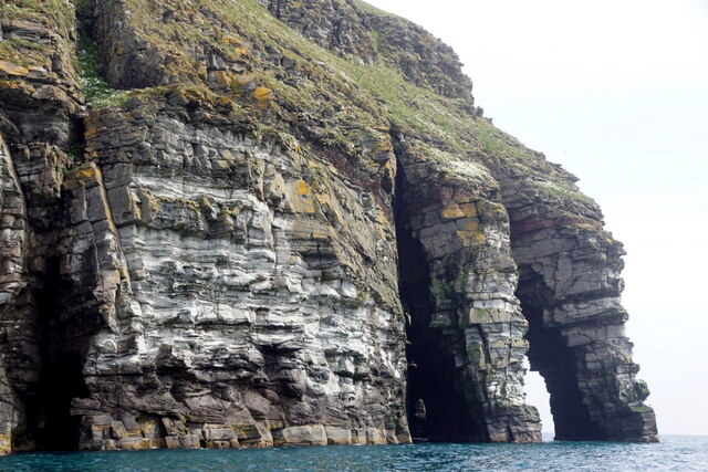
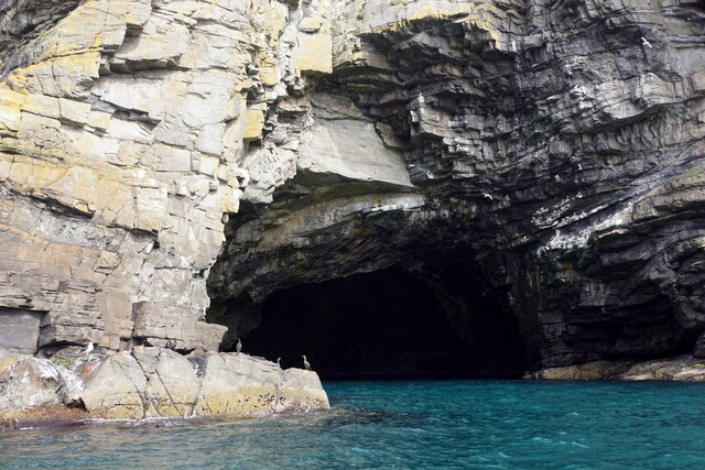
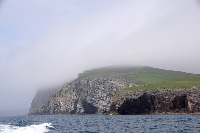
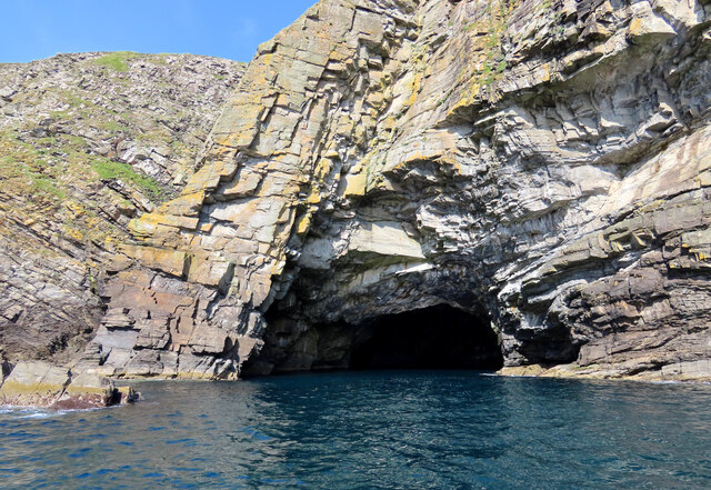
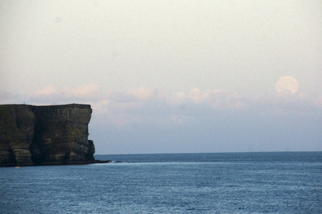
This coastal feature is characterized by its rocky cliffs, which rise dramatically from the sea and provide breathtaking views of the surrounding landscape. The cliffs are composed of sedimentary rocks, including sandstone and shale, which have been shaped over millions of years by the erosive forces of wind and water.

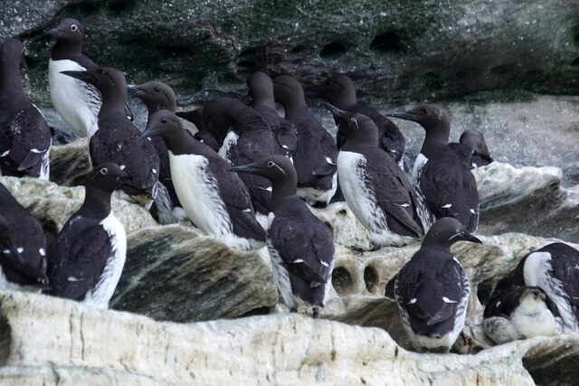
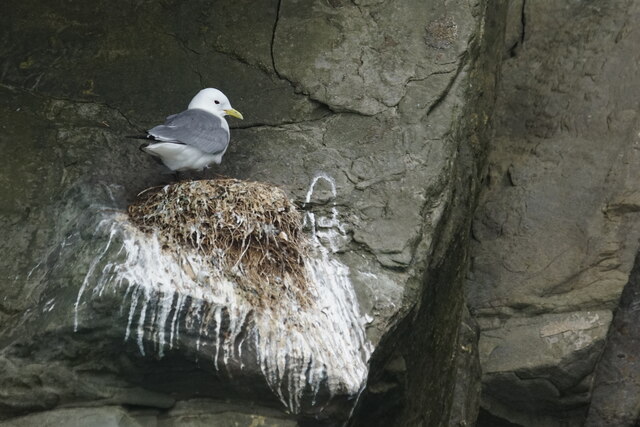
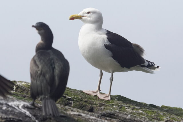
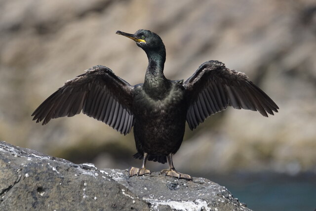
Maatruf is home to a diverse range of flora and fauna, including seabirds such as puffins, guillemots, and razorbills, which nest on the cliff faces. The waters surrounding the headland are also teeming with marine life, including seals, dolphins, and various species of fish.

Due to its prominent location and natural beauty, Maatruf is a popular destination for outdoor enthusiasts and nature lovers. Hiking trails along the headland provide opportunities for visitors to explore the area and appreciate its stunning coastal scenery. The rugged terrain and crashing waves make it an ideal spot for photography and capturing the raw beauty of the Shetland Islands.

In addition to its natural attractions, Maatruf also holds historical significance. The Shetland Islands have a rich cultural heritage, with archaeological sites dating back thousands of years. Maatruf and its surroundings have been inhabited by humans since prehistoric times, and remnants of ancient settlements and structures can still be found in the area.

Overall, Maatruf is a captivating coastal feature that showcases the raw beauty and rich history of the Shetland Islands. Its dramatic cliffs, diverse wildlife, and cultural significance make it a must-visit destination for anyone exploring this remote and enchanting part of Scotland.

If you have any feedback on the listing, please let us know in the comments section below.

Maatruf Images

Images are sourced within 2km of 60.108731/-1.0881237 or Grid Reference HU5036. Thanks to Geograph Open Source API. All images are credited.

Southern slopes of the Ward of Bressay Looking just east of south, with Bard Head on the left.
Southern slopes of the Ward of Bressay
Looking just east of south, with Bard Head on the left.
Bard Head Taken from the Marco Polo cruise ship on the way out of Lerwick.
Bard Head
Taken from the Marco Polo cruise ship on the way out of Lerwick.
Bard Head View from the Lerwick to Aberdeen Ferry.
Bard Head
View from the Lerwick to Aberdeen Ferry.
Mills of the Ord, Bressay, from the sea
Coastline at the Orkneyman's Cave, the Bard, Bressay
Orkneyman's Cave, the Bard, Bressay Although labelled as the Cave of the Bard on OS maps, this is the name by which everyone in Shetland knows it.
Orkneyman's Cave, the Bard, Bressay
Although labelled as the Cave of the Bard on OS maps, this is the name by which everyone in Shetland knows it.
The Giant's Leg, The Bard, Bressay
Bard Head, Bressay, from the sea
In the Orkneyman's Cave, Bard Head, Bressay, looking out
Orkneyman's Cave, Bard Head, Bressay Labelled as Cave of the Bard on the map, but no-one locally uses that name.
Orkneyman's Cave, Bard Head, Bressay
Labelled as Cave of the Bard on the map, but no-one locally uses that name.
Mills of the Ord, Bressay, from the sea
Guillemot (Uria aalge), Bard Head, Bressay
Kittiwake (Rissa tridactyla), Bard Head, Bressay
Great Black-backed Gull (Larus marinus), Bard Head, Bressay
Shag (Gulusus aristotelis), Bard Head, Bressay
The Orkneyman's Cave, Bressay Known locally as the Orkneyman's Cave*, this is the Cave of the Bard on the headland of the same name, Bressay, Shetland.

*A popular myth is that this cave was used as a hiding place for a man from Orkney evading a press-gang; although his boat is said to have washed away in a storm, he managed to climb the cliffs onto Bressay and make his escape.
The Orkneyman's Cave, Bressay
Known locally as the Orkneyman's Cave*, this is the Cave of the Bard on the headland of the same name, Bressay, Shetland. *A popular myth is that this cave was used as a hiding place for a man from Orkney evading a press-gang; although his boat is said to have washed away in a storm, he managed to climb the cliffs onto Bressay and make his escape.
Bard Head, Bressay Taken from about 3.5 km to the west, from the Aberdeen ferry. A full moon is just rising.
Bard Head, Bressay
Taken from about 3.5 km to the west, from the Aberdeen ferry. A full moon is just rising.
The Giant's Leg A sea arch at the end of Bard Head, the most southerly point of Bressay.
The Giant's Leg
A sea arch at the end of Bard Head, the most southerly point of Bressay.
Show me another place!

Maatruf is located at Grid Ref: HU5036 (Lat: 60.108731, Lng: -1.0881237)

Unitary Authority: Shetland Islands

Police Authority: Highlands and Islands

What 3 Words

///sample.rebel.alright. Near Lerwick, Shetland Islands

Related Wikis

Bressay transmitting station

Bressay transmitting station is a broadcasting transmission facility for the Shetland Islands, located on the isle of Bressay, owned and operated by Arqiva...

Bressay

Bressay (Scots: Bressa) is a populated island in the Shetland archipelago of Scotland. == Geography and geology == Bressay lies due south of Whalsay, west...

Holm of Noss

The Holm of Noss or Cradle Holm is an uninhabited islet of the Shetland Islands. It is about 48m at its highest point. == Geography and geology == It is...

Lerwick and Bressay Parish Church

Lerwick and Bressay Parish Church is the largest Church of Scotland congregation in Shetland, serving the islands' capital Lerwick and the surrounding...

Isle of Noss

The Isle of Noss or Noss (Scots: Noss) is a small, previously inhabited island in Shetland, Scotland. Noss is separated from the island of Bressay by the...

Shetland Library

Shetland Library is the public library service of Shetland, with its main branch based in Lerwick. Membership is open to both residents of and visitors...

Lerwick Town Hall

Lerwick Town Hall is a municipal building located on Hillhead in Lerwick, Shetland, Scotland. It is used as an events venue and registrar's office. The...

Gilbert Bain Hospital

The Gilbert Bain Hospital is a rural general hospital in the burgh of Lerwick, Shetland, Scotland. It is managed by NHS Shetland. == History == The hospital...

Related Videos

BRESSAY AND NOSS,SHETLAND-2017

BressayandNoss #Ferry #Lerwick #Shetland Traveling Shetland Bressay, seven minutes by ferry from Lerwick, offers Shetland in ...

Nearby Amenities

Located within 500m of 60.108731,-1.0881237
Source: bing
Lat/Long: 60.1104719/-1.0937693
Source: bing
Lat/Long: 60.1097413/-1.0922045
Source: bing
Lat/Long: 60.1081644/-1.0883718
Source: bing
Lat/Long: 60.1080384/-1.0860302
Source: bing
Lat/Long: 60.1083129/-1.081973
Source: bing
Lat/Long: 60.1063693/-1.0808666
Source: bing
Lat/Long: 60.1064982/-1.0805007
Source: bing
Lat/Long: 60.1065802/-1.0813221
Source: bing
Lat/Long: 60.1065858/-1.0806918
Source: bing
Lat/Long: 60.1066363/-1.0810745
Source: bing
Lat/Long: 60.1068775/-1.0813784
Source: bing
Lat/Long: 60.1070626/-1.0815247
Source: bing
Lat/Long: 60.107085/-1.0817498
Source: bing
Lat/Long: 60.1071523/-1.0815697
Source: bing
Lat/Long: 60.1072028/-1.0817948
Source: bing
Lat/Long: 60.1072645/-1.081626
Source: bing
Lat/Long: 60.1074002/-1.0820223
Source: bing
Lat/Long: 60.1077619/-1.0820485
Source: bing
Lat/Long: 60.1077855/-1.0887373
Source: bing
Lat/Long: 60.1077877/-1.081941
Source: bing
Lat/Long: 60.1078649/-1.08861
Source: bing
Lat/Long: 60.1078836/-1.0891746
Source: bing
Lat/Long: 60.1079246/-1.0818455
Source: bing
Lat/Long: 60.1079838/-1.0891671
Source: bing
Lat/Long: 60.1079958/-1.0874634
Source: bing
Lat/Long: 60.1080005/-1.087753
Source: bing
Lat/Long: 60.1080102/-1.0885454
Source: bing
Lat/Long: 60.1080416/-1.0818495
Source: bing
Lat/Long: 60.1080473/-1.086343
Source: bing
Lat/Long: 60.1080485/-1.0886484
Source: bing
Lat/Long: 60.10806/-1.0880555
Source: bing
Lat/Long: 60.1080657/-1.085913
Source: bing
Lat/Long: 60.1080989/-1.0867949
Source: bing
Lat/Long: 60.1081214/-1.0886202
Source: bing
Lat/Long: 60.1081385/-1.0865721
Source: bing
Lat/Long: 60.1081499/-1.085823
Source: bing
Lat/Long: 60.1081544/-1.087169
Source: bing
Lat/Long: 60.1081544/-1.0895013
Source: bing
Lat/Long: 60.1081578/-1.0886821
Source: bing
Lat/Long: 60.1081665/-1.0820604
Source: bing
Lat/Long: 60.1082059/-1.0898754
Source: bing
Lat/Long: 60.1082258/-1.0860144
Source: bing
Lat/Long: 60.1082417/-1.0869199
Source: bing
Lat/Long: 60.1082536/-1.0855528
Source: bing
Lat/Long: 60.1082784/-1.0885358
Source: bing
Lat/Long: 60.1083041/-1.0857217
Source: bing
Lat/Long: 60.1083238/-1.085581
Source: bing
Lat/Long: 60.1083326/-1.0818822
Source: bing
Lat/Long: 60.1083455/-1.0868379
Source: bing
Lat/Long: 60.1083658/-1.0858286
Source: bing
Lat/Long: 60.1083746/-1.0819892
Source: bing
Lat/Long: 60.1083844/-1.0901141
Source: bing
Lat/Long: 60.1083963/-1.089939
Source: bing
Lat/Long: 60.1084307/-1.0817641
Source: bing
Lat/Long: 60.1084644/-1.0821636
Source: bing
Lat/Long: 60.108484/-1.0818879
Source: bing
Lat/Long: 60.1084976/-1.0858736
Source: bing
Lat/Long: 60.1085232/-1.0902494
Source: bing
Lat/Long: 60.1085272/-1.0900186
Source: bing
Lat/Long: 60.1085733/-1.0856485
Source: bing
Lat/Long: 60.108653/-1.0905116
Source: bing
Lat/Long: 60.108666/-1.0903847
Source: bing
Lat/Long: 60.1086687/-1.0857667
Source: bing
Lat/Long: 60.1087112/-1.0823212
Source: bing
Lat/Long: 60.1087332/-1.0858792
Source: bing
Lat/Long: 60.1087453/-1.0906075
Source: bing
Lat/Long: 60.1088037/-1.0822536
Source: bing
Lat/Long: 60.1088117/-1.0858792
Source: bing
Lat/Long: 60.1088229/-1.0859636
Source: bing
Lat/Long: 60.1088326/-1.0904881
Source: bing
Lat/Long: 60.1089632/-1.0860593
Source: bing
Lat/Long: 60.1089636/-1.0823493
Source: bing
Lat/Long: 60.1089674/-1.0903528
Source: bing
Lat/Long: 60.109023/-1.0905279
Source: bing
Lat/Long: 60.1090337/-1.0832159
Source: bing
Lat/Long: 60.1090505/-1.0825688
Source: bing
Lat/Long: 60.1090561/-1.0833622
Source: bing
Lat/Long: 60.1090898/-1.0828333
Source: bing
Lat/Long: 60.1090954/-1.0831878
Source: bing
Lat/Long: 60.1091034/-1.0860931
Source: bing
Lat/Long: 60.1091178/-1.0825069
Source: bing
Lat/Long: 60.109137/-1.0860143
Source: bing
Lat/Long: 60.1091374/-1.0835536
Source: bing
Lat/Long: 60.1091655/-1.0833228
Source: bing
Lat/Long: 60.1091711/-1.0823774
Source: bing
Lat/Long: 60.1091732/-1.0855261
Source: bing
Lat/Long: 60.1091926/-1.0844544
Source: bing
Lat/Long: 60.1091935/-1.0827826
Source: bing
Lat/Long: 60.109197/-1.0854067
Source: bing
Lat/Long: 60.1091991/-1.0835648
Source: bing
Lat/Long: 60.109201/-1.0860354
Source: bing
Lat/Long: 60.1092168/-1.0856176
Source: bing
Lat/Long: 60.109236/-1.0860908
Source: bing
Lat/Long: 60.1092386/-1.085339
Source: bing
Lat/Long: 60.1092403/-1.0843728
Source: bing
Lat/Long: 60.109244/-1.0824056
Source: bing
Lat/Long: 60.109244/-1.083064
Source: bing
Lat/Long: 60.1092487/-1.0842771
Source: bing
Lat/Long: 60.1092491/-1.0839002
Source: bing
Lat/Long: 60.1092496/-1.083351
Source: bing
Lat/Long: 60.1092529/-1.0844684
Source: bing
Lat/Long: 60.1092613/-1.084761
Source: bing
Lat/Long: 60.1092655/-1.0852675
Source: bing
Lat/Long: 60.1092782/-1.0842208
Source: bing
Lat/Long: 60.1092791/-1.0905973
Source: bing
Lat/Long: 60.1092852/-1.0853407
Source: bing
Lat/Long: 60.1092901/-1.0840859
Source: bing
Lat/Long: 60.1092902/-1.0860632
Source: bing
Lat/Long: 60.1092908/-1.0848792
Source: bing
Lat/Long: 60.109295/-1.0850705
Source: bing
Lat/Long: 60.1093085/-1.0830302
Source: bing
Lat/Long: 60.109314/-1.0858802
Source: bing
Lat/Long: 60.1093205/-1.0837967
Source: bing
Lat/Long: 60.109323/-1.0845219
Source: bing
Lat/Long: 60.1093239/-1.0856812
Source: bing
Lat/Long: 60.1093337/-1.0828501
Source: bing
Lat/Long: 60.1093338/-1.0854505
Source: bing
Lat/Long: 60.1093441/-1.0844009
Source: bing
Lat/Long: 60.1093457/-1.0854345
Source: bing
Lat/Long: 60.1093497/-1.085542
Source: bing
Lat/Long: 60.1093505/-1.0905615
Source: bing
Lat/Long: 60.1093576/-1.0855141
Source: bing
Lat/Long: 60.1093651/-1.0846991
Source: bing
Lat/Long: 60.1093806/-1.0836595
Source: bing
Lat/Long: 60.1093861/-1.0841589
Source: bing
Lat/Long: 60.1093898/-1.0832047
Source: bing
Lat/Long: 60.1093931/-1.084505
Source: bing
Lat/Long: 60.1093959/-1.0846063
Source: bing
Lat/Long: 60.1093982/-1.0828164
Source: bing
Lat/Long: 60.1094061/-1.0907406
Source: bing
Lat/Long: 60.1094231/-1.0856972
Source: bing
Lat/Long: 60.1094459/-1.0825519
Source: bing
Lat/Long: 60.1094487/-1.0822987
Source: bing
Lat/Long: 60.1094824/-1.0822199
Source: bing
Lat/Long: 60.1094831/-1.0836495
Source: bing
Lat/Long: 60.1094989/-1.0838007
Source: bing
Lat/Long: 60.1095011/-1.0833629
Source: bing
Lat/Long: 60.1095049/-1.0834744
Source: bing
Lat/Long: 60.1095497/-1.0822311
Source: bing
Lat/Long: 60.1095525/-1.0832328
Source: bing
Lat/Long: 60.1095845/-1.0906968
Source: bing
Lat/Long: 60.1095954/-1.091799
Source: bing
Lat/Long: 60.1096014/-1.0917195
Source: bing
Lat/Long: 60.1096182/-1.0907764
Source: bing
Lat/Long: 60.1096254/-1.082158
Source: bing
Lat/Long: 60.109631/-1.082293
Source: bing
Lat/Long: 60.1096391/-1.0917871
Source: bing
Lat/Long: 60.1096529/-1.0915086
Source: bing
Lat/Long: 60.1096534/-1.0832441
Source: bing
Lat/Long: 60.1096619/-1.0834185
Source: bing
Lat/Long: 60.1096698/-1.0911345
Source: bing
Lat/Long: 60.1096767/-1.0917712
Source: bing
Lat/Long: 60.1096847/-1.0921731
Source: bing
Lat/Long: 60.1097278/-1.0908299
Source: bing
Lat/Long: 60.1098294/-1.092384
Source: bing
Lat/Long: 60.109934/-1.0963768
Source: bing
Lat/Long: 60.1099499/-1.0952468
Source: bing
Lat/Long: 60.1099657/-1.0965837
Source: bing
Lat/Long: 60.1099816/-1.0961699
Source: bing
Lat/Long: 60.109996/-1.092575
Source: bing
Lat/Long: 60.1100337/-1.0927103
Source: bing
Lat/Long: 60.110049/-1.0965997
Source: bing
Lat/Long: 60.1100609/-1.0963132
Source: bing
Lat/Long: 60.1100694/-1.0926426
Source: bing
Lat/Long: 60.1101521/-1.0949762
Source: bing
Lat/Long: 60.1101923/-1.09275
Source: bing
Lat/Long: 60.1102096/-1.0928832
Source: bing
Lat/Long: 60.1102116/-1.0952627
Source: bing
Lat/Long: 60.1102716/-1.0927222
Source: bing
Lat/Long: 60.1103266/-1.0945146
Source: bing
Lat/Long: 60.1103346/-1.0949364
Source: bing
Lat/Long: 60.1103663/-1.0928115
Source: bing
Lat/Long: 60.110406/-1.0937984
Source: bing
Lat/Long: 60.1104972/-1.0933368
Source: bing
Lat/Long: 60.1097986/-1.0818422
The data included in this document is from www.openstreetmap.org. The data is made available under ODbL.

Have you been to Maatruf?

Leave your review of Maatruf below (or comments, questions and feedback).