The Neap

Coastal Feature, Headland, Point in Shetland

Scotland

The Neap

Papa Stour and Foula Taken on the B9078 between Burnside and Eshaness, Shetland, I am looking out towards the islands of Papa Stour (left of shot) and Foula beyond.
Papa Stour and Foula Credit: Carroll Pierce

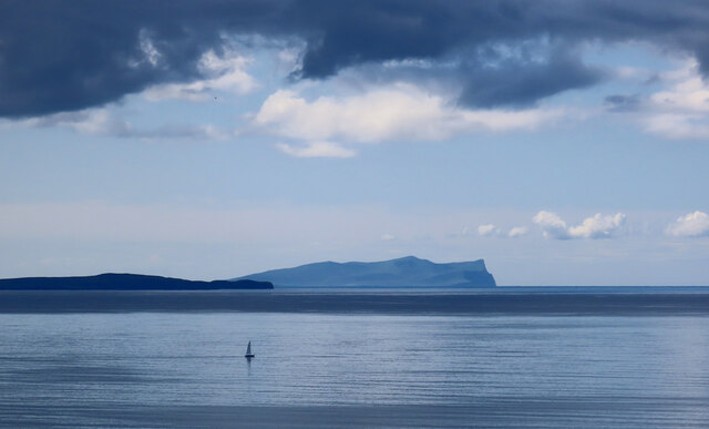
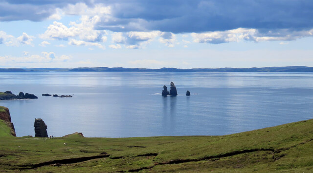
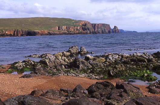
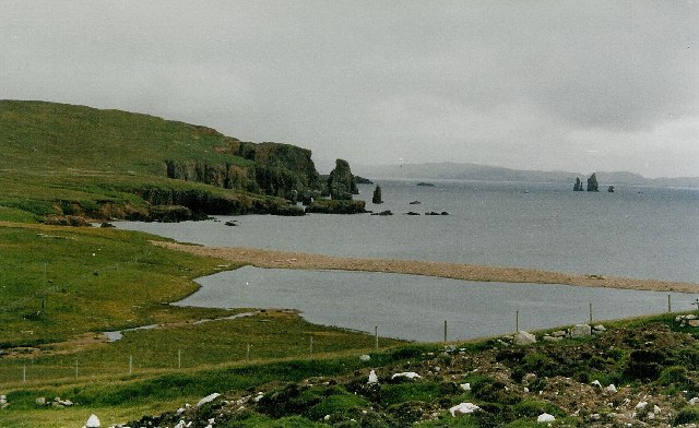
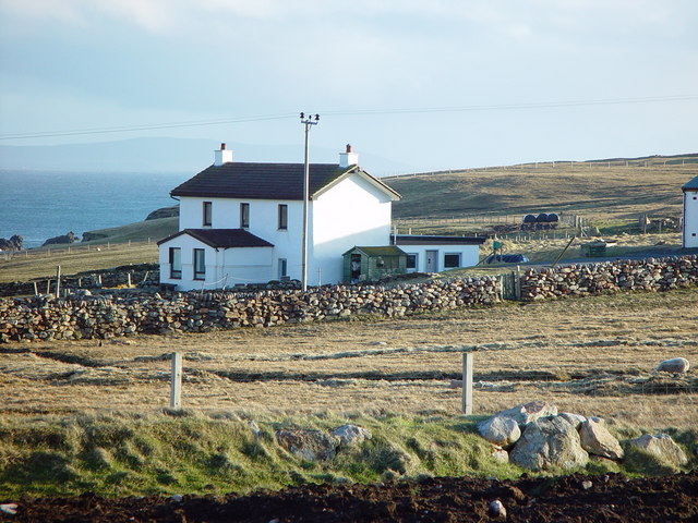
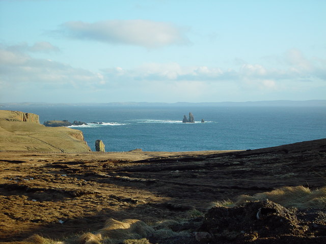
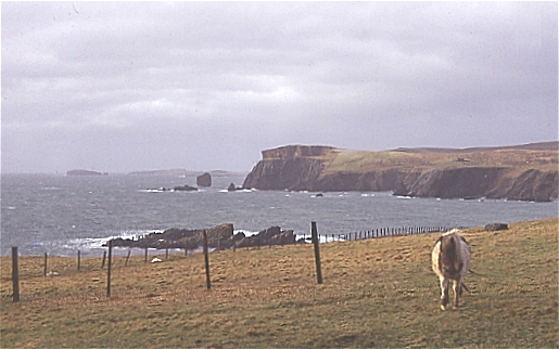
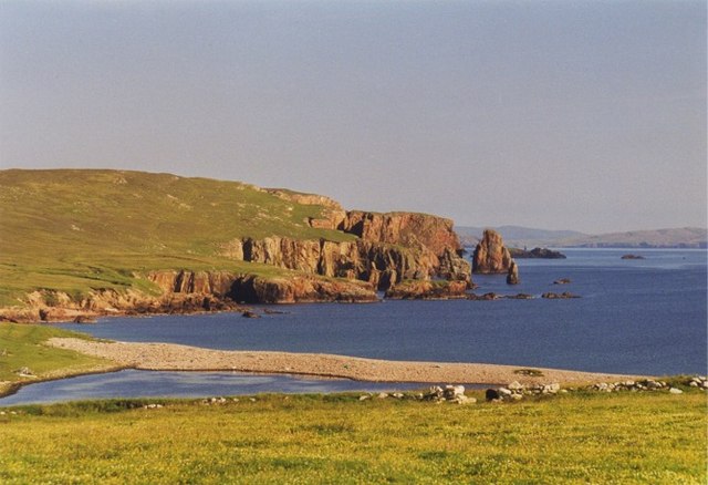
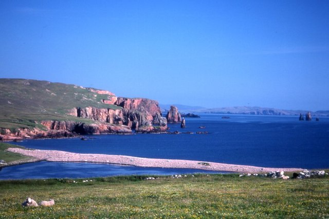
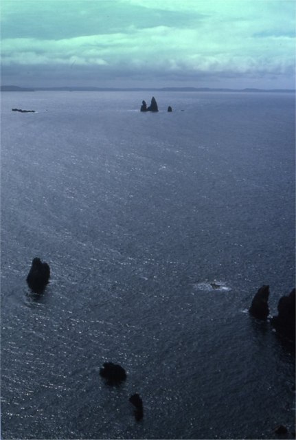
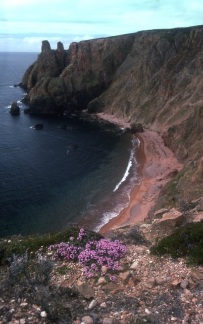
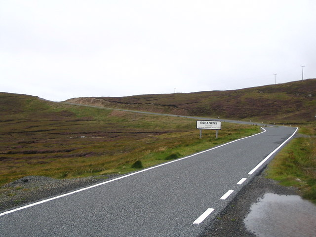
The Neap is a prominent coastal feature located in Shetland, an archipelago in Scotland. It is a headland or point that juts out into the sea, offering stunning views and a distinct geological profile. Situated on the eastern coast of Shetland, The Neap is known for its rugged cliffs, rough terrain, and dramatic landscape.

The headland is characterized by its tall cliffs, which reach impressive heights, providing a nesting ground for various seabird species such as guillemots and puffins. The cliffs are composed of sedimentary rocks, predominantly sandstone and shale, which have been shaped by the relentless force of the waves over centuries. This has resulted in unique geological formations, including sea caves, natural arches, and stacks.

Visitors to The Neap can witness the power of the North Sea as it crashes against the cliffs, creating a mesmerizing spectacle. The coastal area is also home to diverse marine life, with common sightings of seals, dolphins, and whales in the surrounding waters.

The Neap is a popular destination for outdoor enthusiasts, offering opportunities for hiking, birdwatching, and photography. A coastal path runs along the headland, providing access to the stunning views and allowing visitors to explore the area at their own pace.

Due to its exposed location, The Neap can experience harsh weather conditions, including strong winds and rough seas. It is advisable for visitors to come prepared with appropriate clothing and take caution when venturing close to the cliff edges.

Overall, The Neap is a remarkable coastal feature that showcases the raw beauty of Shetland's coastline, attracting nature lovers and adventure seekers from near and far.

If you have any feedback on the listing, please let us know in the comments section below.

The Neap Images

Images are sourced within 2km of 60.483454/-1.5369335 or Grid Reference HU2577. Thanks to Geograph Open Source API. All images are credited.

Papa Stour and Foula Taken on the B9078 between Burnside and Eshaness, Shetland, I am looking out towards the islands of Papa Stour (left of shot) and Foula beyond.
Papa Stour and Foula
Taken on the B9078 between Burnside and Eshaness, Shetland, I am looking out towards the islands of Papa Stour (left of shot) and Foula beyond.
The Drongs Taken from the B9078 between Burnside and Eshaness, Shetland, I am looking across Sand Wick to the sea stacks known at The Drongs. Papa Stour can be seen in the distance.
The Drongs
Taken from the B9078 between Burnside and Eshaness, Shetland, I am looking across Sand Wick to the sea stacks known at The Drongs. Papa Stour can be seen in the distance.
Brae Wick This is looking south-east from Braewick towards the red granite cliffs of The Neap
Brae Wick
This is looking south-east from Braewick towards the red granite cliffs of The Neap
Brae Wick and the Drongs View from the roadside above Braewick village.  In the foreground is Braewick Loch, beyond the beach is Brae Wick (the bay) itself.  Out to sea, the bizarre formation of the Drongs.
Brae Wick and the Drongs
View from the roadside above Braewick village. In the foreground is Braewick Loch, beyond the beach is Brae Wick (the bay) itself. Out to sea, the bizarre formation of the Drongs.
Braewick Cottage, Braewick, Shetland A relatively modern house set on the north side of Brae Wick.
Braewick Cottage, Braewick, Shetland
A relatively modern house set on the north side of Brae Wick.
View over Heads of Grocken, Eshaness, Shetland Looking out over the Heads of Grocken with 'The Drongs' the sea stacks in the distance.
View over Heads of Grocken, Eshaness, Shetland
Looking out over the Heads of Grocken with 'The Drongs' the sea stacks in the distance.
Helga water, near Hillswick, Shetland Shetland is unlikely ever to have a hosepipe ban, there are many many lochs and plentiful rainfall. This is Helga Water near the road to Eshaness.
Helga water, near Hillswick, Shetland
Shetland is unlikely ever to have a hosepipe ban, there are many many lochs and plentiful rainfall. This is Helga Water near the road to Eshaness.
Heads of Grocken Looking across the square from above Hillswick on a stormy winter's day. The pony was very inquisitive, and didn't want to be photographed in profile!
Heads of Grocken
Looking across the square from above Hillswick on a stormy winter's day. The pony was very inquisitive, and didn't want to be photographed in profile!
Lagoon at Braewick
Lagoon at Braewick
Brae Wick The beach-head loch of Brae Wick with the bay beyond. The Drongs can just be seen on the far right.
Brae Wick
The beach-head loch of Brae Wick with the bay beyond. The Drongs can just be seen on the far right.
Heads of Grocken Small sea-stacks off the Heads of Grocken, with the Drongs in the distance.
Heads of Grocken
Small sea-stacks off the Heads of Grocken, with the Drongs in the distance.
Beach between Heads of Grocken and the Neap
Entering Eshaness
Entering Eshaness
Roadside quarry West of Helga Water
Roadside quarry
West of Helga Water
Single track road view to Braewick
Helga Water view from the outflow burn
Braewick inflow burn
The Neap Stacks, Braewick Photo taken on a typical wet and windy Shetland day looking out across the stacks beneath the Neap. The third furthest is called the Runk. The Drongs are in the distance.
The Neap Stacks, Braewick
Photo taken on a typical wet and windy Shetland day looking out across the stacks beneath the Neap. The third furthest is called the Runk. The Drongs are in the distance.
Show me another place!

The Neap is located at Grid Ref: HU2577 (Lat: 60.483454, Lng: -1.5369335)

Unitary Authority: Shetland Islands

Police Authority: Highlands and Islands

What 3 Words

///surreal.gushes.preheated. Near Brae, Shetland Islands

Related Wikis

Braehoulland

Braehoulland is a hamlet on Mainland, in Shetland, Scotland. Braehoulland is situated within the parish of Northmaven. Eshaness Community Centre is located...

Tangwick Haa

Tangwick Haa is an historic house and museum in Esha Ness, Northmavine, Shetland. The building has two stories in a rectangular layout and along with the...

The Drongs

The Drongs are a group of sea stacks off the coast of Hillswick Ness, Northmavine, Shetland, Scotland. They lie to the west of the Isle of Westerhouse...

Hillswick

Hillswick is a small village in Northmavine, on the shore of the Atlantic Ocean and lies to the north-north west of Mainland, Shetland, the most northerly...

Esha Ness

Esha Ness, also spelled Eshaness, is a peninsula on the west coast of Northmavine, on the island of Mainland, Shetland, Scotland. Esha Ness Lighthouse...

Johnnie Notions

John Williamson (c. 1730 – c. 1803), more commonly known by the nickname Johnnie Notions (pronounced [ˌdʒoni ˈnoʃəns], JOH-nee-NOH-shəns) was a self-taught...
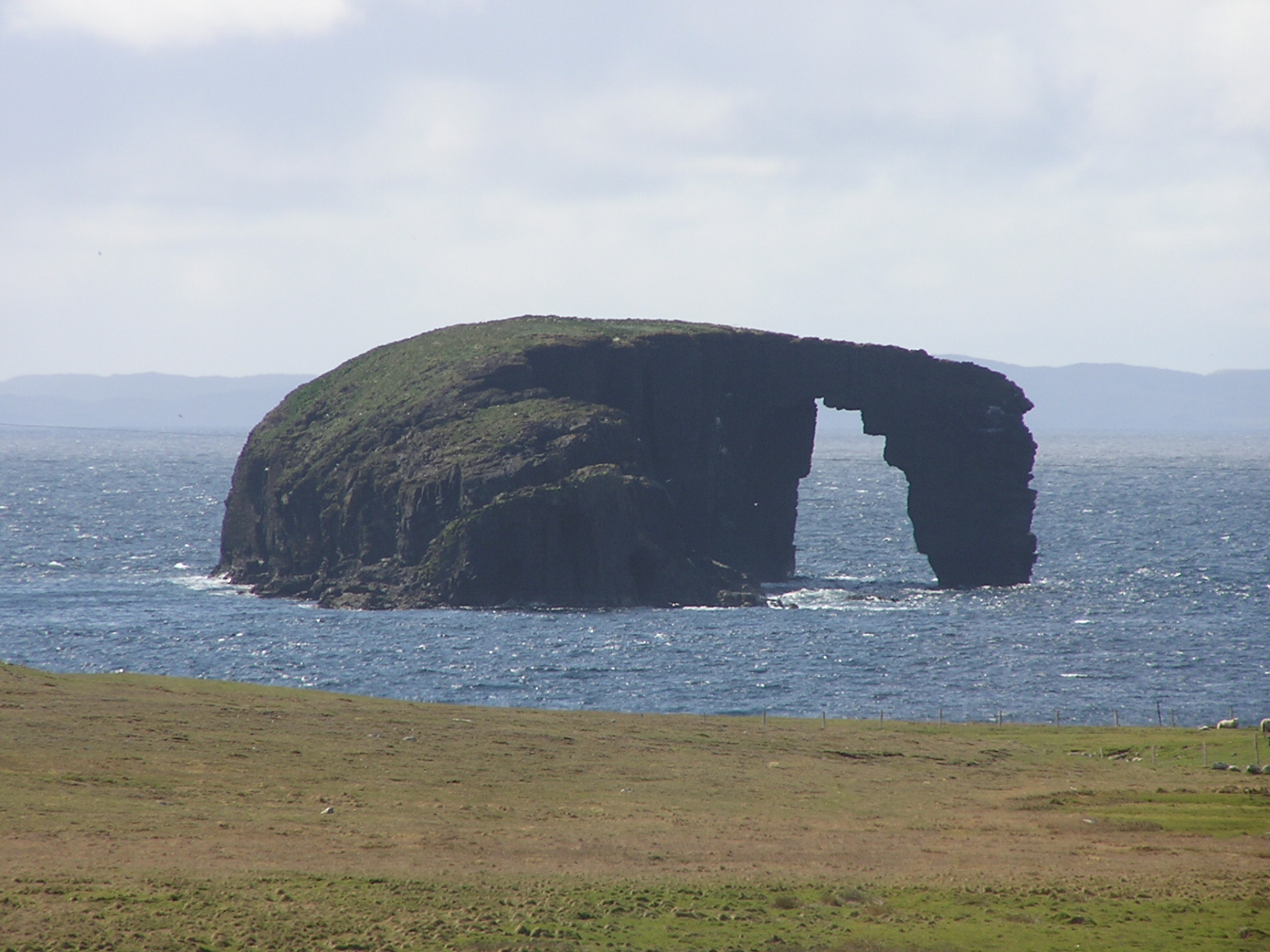
Dore Holm

The Dore Holm is a small uninhabited islet off the south coast of Esha Ness, located in the north-west of Mainland, Shetland, Scotland. Its natural arch...

Assater

Assater (also spelled Assetter) is a hamlet on Mainland, in Shetland, Scotland. Assater is situated in the parish of Northmaven. It is about 1.3 miles...

Nearby Amenities

Located within 500m of 60.483454,-1.5369335
Passing Place
Lat/Long: 60.4875575/-1.5372125
Passing Place
Lat/Long: 60.4871144/-1.5338566
The data included in this document is from www.openstreetmap.org. The data is made available under ODbL.

Have you been to The Neap?

Leave your review of The Neap below (or comments, questions and feedback).