Tor Ness

Coastal Feature, Headland, Point in Orkney

Scotland

Tor Ness

Beacon on Tor Ness and the Berry, Hoy
Beacon on Tor Ness and the Berry, Hoy Credit: Mike Pennington

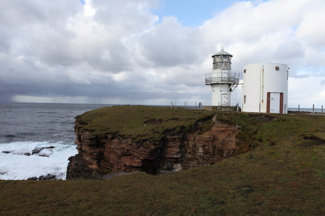
Tor Ness is a coastal headland located on the island of Orkney, off the northeast coast of Scotland. Situated on the northeastern tip of the island, it is known for its stunning natural beauty and rich historical significance.

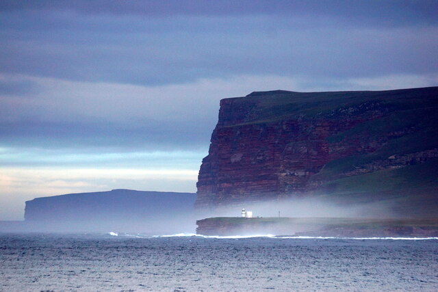
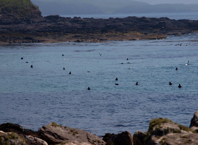
The headland is characterized by its rugged cliffs, which rise dramatically from the North Sea, offering panoramic views of the surrounding waters and the nearby island of Shapinsay. The cliffs are composed of Old Red Sandstone, a geological formation that dates back millions of years. Tor Ness is also home to a diverse array of seabirds, including puffins, guillemots, and razorbills, making it a popular spot for birdwatching enthusiasts.

In addition to its natural beauty, Tor Ness also holds historical importance. It is believed to have been a significant location during the Viking era, with archaeological evidence suggesting the presence of a Norse settlement in the area. Ruins of a Norse longhouse and a burial ground have been discovered, providing valuable insight into the island's past.

Accessible by a coastal path, Tor Ness offers visitors the opportunity to explore its stunning cliffs, observe the abundant wildlife, and immerse themselves in the rich history of Orkney. The headland's rugged and unspoiled beauty, combined with its historical significance, make it a must-visit destination for nature lovers and history enthusiasts alike.

If you have any feedback on the listing, please let us know in the comments section below.

Tor Ness Images

Images are sourced within 2km of 58.778791/-3.2893441 or Grid Reference ND2588. Thanks to Geograph Open Source API. All images are credited.
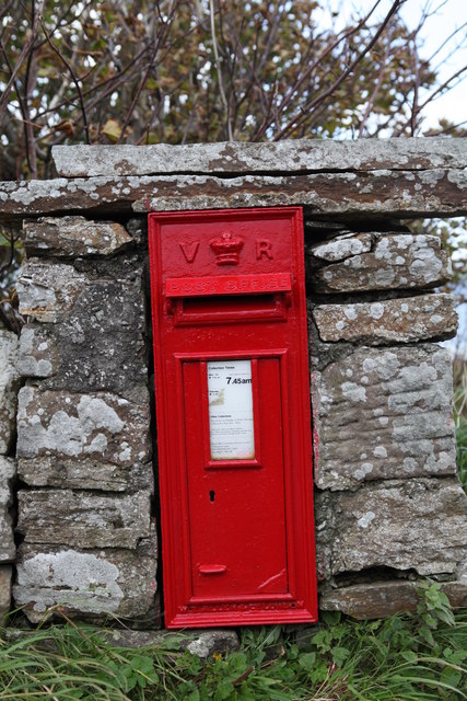
Beacon on Tor Ness and the Berry, Hoy
Melsetter Postbox Victorian Postbos at Melsetter on Hoy [KW16 46]
Melsetter Postbox
Victorian Postbos at Melsetter on Hoy [KW16 46]
Tor Ness light approach Also known as Torness; Kilns Of Hawick and Berry Head
A marvellous setting, with the expanse of Pentland Firth one side and the moors and hills of Hoy the other.
An easy and gentle walk from Melsetter.
This light itself is modern (according to the Northern Lighthouse Board 1980) <span class="nowrap"><a title="http://www.nlb.org.uk/LighthouseLibrary/Lighthouse/Tor-Ness/" rel="nofollow ugc noopener" href="http://www.nlb.org.uk/LighthouseLibrary/Lighthouse/Tor-Ness/">Link</a><img style="margin-left:2px;" alt="External link" title="External link - shift click to open in new window" src="https://s1.geograph.org.uk/img/external.png" width="10" height="10"/></span> 
Powered by an underground cable from Melsetter.
Before the light the area was said to be "a veritable graveyard of wrecks"
Far more lighthouses here <a title="https://www.geograph.org.uk/gallery/lighthouses_8677" href="https://www.geograph.org.uk/gallery/lighthouses_8677">Link</a>
Tor Ness light approach
Also known as Torness; Kilns Of Hawick and Berry Head A marvellous setting, with the expanse of Pentland Firth one side and the moors and hills of Hoy the other. An easy and gentle walk from Melsetter. This light itself is modern (according to the Northern Lighthouse Board 1980) LinkExternal link Powered by an underground cable from Melsetter. Before the light the area was said to be "a veritable graveyard of wrecks" Far more lighthouses here Link
Hoy Paradise - Orth of Hawick The bay below Tor Ness light - Ha Wick. A dream of warm sand, lounging seal, flotsam and peace. BUT only on a day like this!
It is a thunderous and dramatic place on a wild day.
Hoy Paradise - Orth of Hawick
The bay below Tor Ness light - Ha Wick. A dream of warm sand, lounging seal, flotsam and peace. BUT only on a day like this! It is a thunderous and dramatic place on a wild day.
Hoy - the Kilns of Hawick Between the lighthouse and Ha Wick Bay, a short section of geos and pinnacles, overlooking the Atlantic and the entrance to Pentland Firth.
Wonderfully cushioned underfoot.
Hoy - the Kilns of Hawick
Between the lighthouse and Ha Wick Bay, a short section of geos and pinnacles, overlooking the Atlantic and the entrance to Pentland Firth. Wonderfully cushioned underfoot.
Dozing seal in Sands Geo Completely at home, these seal rise and fall in perfect snoozing buoyancy.
On a nice day, such as this, it is possible to watch them for hours.
Only a few minutes' walk from the bus route.
Dozing seal in Sands Geo
Completely at home, these seal rise and fall in perfect snoozing buoyancy. On a nice day, such as this, it is possible to watch them for hours. Only a few minutes' walk from the bus route.
Hoy: postbox № KW17 46, Melsetter A Victorian postbox set into a wall backing on to the western extremity of North Bay. It is emptied at 7:45 each weekday and Saturday morning.

Although Hoy and South Walls are postally within KW16 (Stromness), all the postboxes on the two islands are numbered KW17, presumably in error.
Hoy: postbox № KW17 46, Melsetter
A Victorian postbox set into a wall backing on to the western extremity of North Bay. It is emptied at 7:45 each weekday and Saturday morning. Although Hoy and South Walls are postally within KW16 (Stromness), all the postboxes on the two islands are numbered KW17, presumably in error.
Broughs of the Berry, Hoy These 20m islands have some interesting arches. A hanging crack on the north west side provides some sporting climbing.
Broughs of the Berry, Hoy
These 20m islands have some interesting arches. A hanging crack on the north west side provides some sporting climbing.
Children's den at Ha Wick What looks to be a child's den built from flotsam.  This bay is located on one of the most dangerous stretches of coastline in the country and has been the scene of many tragedies.
Children's den at Ha Wick
What looks to be a child's den built from flotsam. This bay is located on one of the most dangerous stretches of coastline in the country and has been the scene of many tragedies.
Quarry workings on Melsetter Hill This is one of several small disused quarry workings at the summit of Melsetter Hill.
Quarry workings on Melsetter Hill
This is one of several small disused quarry workings at the summit of Melsetter Hill.
Old dyke on Melsetter Hill This dyke which is damaged in many areas has been replaced by a wooden fence.  Melsetter Hill is rough grazing at the summit but the lower slopes are grazed by many cattle.
Old dyke on Melsetter Hill
This dyke which is damaged in many areas has been replaced by a wooden fence. Melsetter Hill is rough grazing at the summit but the lower slopes are grazed by many cattle.
Summit cairn of Melsetter Hill Small cairn at the summit of the hill.
Summit cairn of Melsetter Hill
Small cairn at the summit of the hill.
Post Box, Melsetter House A post box from what I believe was the reign of Queen Victoria.  This one is located in a wall at the entrance to Melsetter House.
Post Box, Melsetter House
A post box from what I believe was the reign of Queen Victoria. This one is located in a wall at the entrance to Melsetter House.
Coastline near Brims A wild and exposed coastline that experiences the full force of weather from the Pentland Firth.  Evidence of much ship wreckage is still to be found along these shores.
Coastline near Brims
A wild and exposed coastline that experiences the full force of weather from the Pentland Firth. Evidence of much ship wreckage is still to be found along these shores.
Grazing land near to Brims The coastline fields of South Walls are used primarily for the grazing of cattle.  There are many fences to cross and stiles are rare.
Grazing land near to Brims
The coastline fields of South Walls are used primarily for the grazing of cattle. There are many fences to cross and stiles are rare.
Rough Grazing near to Tor Ness This photo is typical of the lower ground on Hoy.  Small fenced fields for cattle lower down while the hill ground is used for sheep.
Rough Grazing near to Tor Ness
This photo is typical of the lower ground on Hoy. Small fenced fields for cattle lower down while the hill ground is used for sheep.
Loch of Tor Ness This small loch was a temporary home for four herons today.  The 175 metre high cliffs of The Berry can be seen in the distance.  Very easy walking here on close cropped grazing land.
Loch of Tor Ness
This small loch was a temporary home for four herons today. The 175 metre high cliffs of The Berry can be seen in the distance. Very easy walking here on close cropped grazing land.
Tor Ness Lighthouse (A3600) Built in 1937 this 26 metre tower protects shipping on what is a very hazardous stretch of coastline.  There is much evidence of wreckage along this coast.
Tor Ness Lighthouse (A3600)
Built in 1937 this 26 metre tower protects shipping on what is a very hazardous stretch of coastline. There is much evidence of wreckage along this coast.
Show me another place!

Tor Ness is located at Grid Ref: ND2588 (Lat: 58.778791, Lng: -3.2893441)

Unitary Authority: Orkney Islands

Police Authority: Highlands and Islands

What 3 Words

///padlock.custodian.stutter. Near Lyness, Orkney Islands

Related Wikis

The Needle, Orkney

The Needle is a 70-metre-high (230 ft) sea stack on the island of Hoy, in Orkney, Scotland. It is located on the southwest coast of Hoy at ND243902. There...

Hoglinns Water

Hoglinns Water is a small freshwater loch in the south of the island of Hoy, Orkney. It drains in to Heldale Water via Hoglinns Burn. The loch was surveyed...

Brims, Orkney

Brims is a village at the southern point of the island of Hoy, in Orkney, Scotland. The settlement is within the parish of Walls and Flotta. The RNLI lifeboat...

RNLB Thomas McCunn (ON 759)

RNLB Thomas McCunn (ON 759) is a 45ft 6in Watson-class lifeboat stationed at Longhope in Orkney, Scotland, from January 1933 until April 1962. During...

Nearby Amenities

Located within 500m of 58.778791,-3.2893441
Tor Ness
Man Made: lighthouse
Seamark Light Character: Fl
Seamark Light Colour: white
Seamark Light Height: 21
Seamark Light Period: 3
Seamark Light Range: 10
Seamark Light Reference: A 3600
Seamark Light Sequence: 0.3+(2.7)
Seamark Name: Tor Ness
Seamark Type: light_minor
Wikidata: Q28858425
Lat/Long: 58.7783038/-3.2963372
Tor Ness
Place: locality
Lat/Long: 58.7764345/-3.2894188
Wastlee Moor
Place: locality
Lat/Long: 58.779643/-3.2903746
Power: pole
Lat/Long: 58.7794535/-3.2808298
The data included in this document is from www.openstreetmap.org. The data is made available under ODbL.

Have you been to Tor Ness?

Leave your review of Tor Ness below (or comments, questions and feedback).