Rubha Bhrolluim
Coastal Feature, Headland, Point in Ross-shire
Scotland
Rubha Bhrolluim

Rubha Bhrolluim is a prominent headland located on the northwestern coast of Scotland, specifically in the region of Ross-shire. Jutting out into the North Atlantic Ocean, this coastal feature is known for its rugged beauty and stunning views. The name "Rubha Bhrolluim" is derived from the Gaelic language, with "Rubha" meaning "point" or "headland," and "Bhrolluim" likely referring to a local or historical figure.
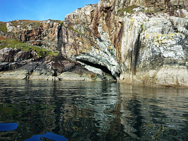
The headland is characterized by steep cliffs that rise dramatically from the sea, providing a natural vantage point for visitors to enjoy sweeping panoramas of the surrounding ocean and coastline. These cliffs are composed primarily of sandstone and slate, which have been shaped over centuries by the relentless crashing of waves.
At the tip of Rubha Bhrolluim, there is a small, sheltered beach nestled between the cliffs. This secluded cove is a popular spot for picnicking and sunbathing during the summer months. The beach is comprised of smooth pebbles and offers a peaceful retreat from the sometimes wild and windswept headland.
Wildlife enthusiasts are drawn to Rubha Bhrolluim due to its rich biodiversity. The headland is home to a variety of bird species, including puffins, razorbills, and guillemots, which nest in the cliffs during the breeding season. Seals can also be spotted lounging on nearby rock formations, while dolphins and porpoises occasionally make appearances offshore.
Overall, Rubha Bhrolluim is a captivating coastal feature that combines stunning natural beauty with abundant wildlife. Its rugged cliffs, tranquil beach, and picturesque views make it a must-visit destination for nature lovers and those seeking a peaceful escape.
If you have any feedback on the listing, please let us know in the comments section below.
Rubha Bhrolluim Images
Images are sourced within 2km of 57.928024/-6.5181747 or Grid Reference NB3202. Thanks to Geograph Open Source API. All images are credited.


Rubha Bhrolluim is located at Grid Ref: NB3202 (Lat: 57.928024, Lng: -6.5181747)
Unitary Authority: Na h-Eileanan an Iar
Police Authority: Highlands and Islands
What 3 Words
///exacted.whites.skinning. Near Tarbert, Na h-Eileanan Siar
Related Wikis

Park, Lewis
Park (Scottish Gaelic: A' Phàirc), also known as South Lochs, is a huge area of land connected to the rest of Lewis only by a narrow neck between Loch...

Garbh Eilean, Shiant Islands
Garbh Eilean (Scottish Gaelic Rough Isle) is one of the Shiant Islands at the south end of the Minch on the west coast of Scotland. == Geology == In geological...

Shiant Islands
The Shiant Islands (; Scottish Gaelic: Na h-Eileanan Mòra [nə ˈhelanən ˈmoːɾə] or Na h-Eileanan Seunta [nə ˈhelanən ˈʃiant̪ə] ) or Shiant Isles are a privately...

Eilean Liubhaird
Eilean Liubhaird or Eilean Iubhard is an island in the Outer Hebrides, to the east of Lewis. == Geography and geology == The rock is "gneiss bedrock with...
Nearby Amenities
Located within 500m of 57.928024,-6.5181747Have you been to Rubha Bhrolluim?
Leave your review of Rubha Bhrolluim below (or comments, questions and feedback).