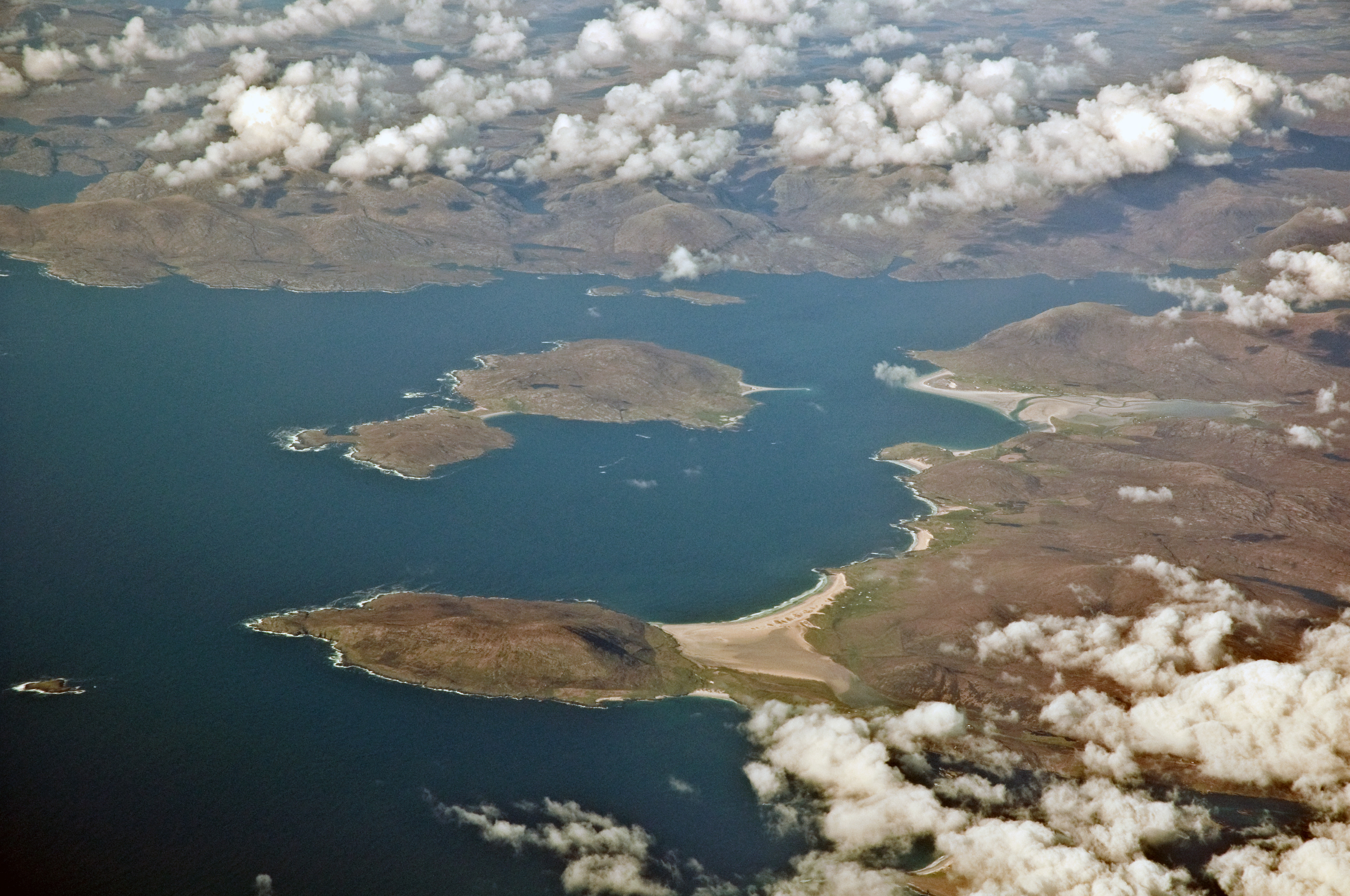
Crago

Coastal Feature, Headland, Point in Inverness-shire

Scotland

Crago

View to Luskentyre From a viewpoint on the A859.
View to Luskentyre Credit: Richard Dorrell

Crago is a prominent coastal feature located in Inverness-shire, Scotland. It is specifically classified as a headland or a point due to its distinct geographical characteristics. Situated along the rugged coastline, Crago juts out into the North Sea, offering breathtaking views of the surrounding landscape.

This headland is characterized by its towering cliffs that rise dramatically from the sea, forming a natural barrier between land and water. The cliffs are composed of various types of rock, including sandstone and granite, which have been shaped over centuries by the relentless forces of erosion. As a result, Crago boasts a rugged and weathered appearance.

The headland is also home to a diverse array of flora and fauna. The cliffs provide a suitable nesting habitat for numerous seabird species, including gulls and puffins, which can be observed during certain times of the year. The surrounding waters are teeming with marine life, making Crago an ideal spot for fishing and wildlife enthusiasts.

Visitors to Crago can enjoy a range of outdoor activities. The headland offers excellent opportunities for hiking and exploration, with various trails that wind along the cliffs and provide panoramic views of the sea. The nearby beaches are perfect for leisurely strolls or picnics, while the surrounding waters are popular for surfing and other water sports.

Crago is a captivating coastal feature that showcases the natural beauty and diversity of Inverness-shire's coastline. Its striking cliffs, abundant wildlife, and recreational opportunities make it a must-visit destination for nature lovers and adventure seekers alike.

If you have any feedback on the listing, please let us know in the comments section below.

Crago Images

Images are sourced within 2km of 57.871119/-6.9375275 or Grid Reference NG0797. Thanks to Geograph Open Source API. All images are credited.

View to Luskentyre From a viewpoint on the A859.
View to Luskentyre
From a viewpoint on the A859.
Traigh Sheileboist in 1981
Tràigh Losgaintir at low tide
Double Rainbow at Seilebost
Footprints in the sand at Corran Sheileboist
Coastline of Harris
Coastline of Harris
Coast of Harris
Coast of Harris
Scenic parking spot
Scenic parking spot
Abhainn Sheileaboist
Traigh Sheileboist On a perfect day of azure seas and silver sands, Hebridean beaches are unsurpassed!  Traigh Losgaintir (Luskentyre) in the distance.

The blues are true - no Photoshopping here!
Traigh Sheileboist
On a perfect day of azure seas and silver sands, Hebridean beaches are unsurpassed! Traigh Losgaintir (Luskentyre) in the distance. The blues are true - no Photoshopping here!
Primroses above Traigh Sheileboist On a perfect day of azure seas and silver sands, Hebridean beaches are unsurpassed!  Traigh Losgaintir (Luskentyre) in the distance.

The blues are true - no Photoshopping here!
Primroses above Traigh Sheileboist
On a perfect day of azure seas and silver sands, Hebridean beaches are unsurpassed! Traigh Losgaintir (Luskentyre) in the distance. The blues are true - no Photoshopping here!
Traigh Sheileboist On a perfect day of azure seas and silver sands, Hebridean beaches are unsurpassed!  This one is busy - I can count six people on it!  Traigh Losgaintir (Luskentyre) in the distance.

The blues are true - no Photoshopping here!
Traigh Sheileboist
On a perfect day of azure seas and silver sands, Hebridean beaches are unsurpassed! This one is busy - I can count six people on it! Traigh Losgaintir (Luskentyre) in the distance. The blues are true - no Photoshopping here!
Tràigh Losgaintir Looking across the beach from the south side of the estuary.
Tràigh Losgaintir
Looking across the beach from the south side of the estuary.
Tràigh Losgaintir and Taransay Looking west to the island of Taransay, beyond the dunes of Luskentyre.
Tràigh Losgaintir and Taransay
Looking west to the island of Taransay, beyond the dunes of Luskentyre.
Abhainn Gil an Tàilleir runs through Tràigh Losgaintir The burn draining An Coileach runs into the estuary. Beyond is the rocky land of Frith Losgaintir.
Abhainn Gil an Tàilleir runs through Tràigh Losgaintir
The burn draining An Coileach runs into the estuary. Beyond is the rocky land of Frith Losgaintir.
Frith Losgaintir Seen from across the head of the Luskentyre estuary. Note the foreground covered with lugworm casts <a href="https://www.geograph.org.uk/photo/4991997">NG0897 : Lugworm casts at Luskentyre</a>.
Frith Losgaintir
Seen from across the head of the Luskentyre estuary. Note the foreground covered with lugworm casts NG0897 : Lugworm casts at Luskentyre.
Lugworm casts at Luskentyre Lugworms [polychaete worms - Arenicola marina] live in U-shaped, mucus lined burrows in sand. The depressions in the sand mark the entrance to a burrow, where sand is taken in; after processing to extract nutrients the sand is excreted as a cast at the other end. They occurred in abundance in the sands near the head of the Luskentyre estuary <a href="https://www.geograph.org.uk/photo/4991983">NG0897 : Frith Losgaintir</a>.
Lugworm casts at Luskentyre
Lugworms [polychaete worms - Arenicola marina] live in U-shaped, mucus lined burrows in sand. The depressions in the sand mark the entrance to a burrow, where sand is taken in; after processing to extract nutrients the sand is excreted as a cast at the other end. They occurred in abundance in the sands near the head of the Luskentyre estuary NG0897 : Frith Losgaintir.
Marks in the sand at Luskentyre Caused by the siphons of a bivalve mollusc, the Peppery Furrow Shell [Scrobicularia plana]. Digging down would reveal the animals at the centre of the radiating depressions left by the inhalant and exhalant tubes.
Marks in the sand at Luskentyre
Caused by the siphons of a bivalve mollusc, the Peppery Furrow Shell [Scrobicularia plana]. Digging down would reveal the animals at the centre of the radiating depressions left by the inhalant and exhalant tubes.
Show me another place!

Crago is located at Grid Ref: NG0797 (Lat: 57.871119, Lng: -6.9375275)

Unitary Authority: Na h-Eileanan an Iar

Police Authority: Highlands and Islands

What 3 Words

///instructs.drummers.tolerable. Near Tarbert, Na h-Eileanan Siar

Nearby Locations

Crago Fadhail Sheileboist

Related Wikis

Luskentyre

Luskentyre (Scottish Gaelic: Losgaintir) is a sparse settlement on the west coast of Harris, in the Outer Hebrides, Scotland. Luskentyre is situated within...

Borve, Harris

Borve (Scottish Gaelic: Na Buirgh) is a village in Harris in the Outer Hebrides, Scotland. Borve is also within the parish of Harris, and is on the A859...

Taransay

Taransay (Scottish Gaelic: Tarasaigh, pronounced [ˈt̪ʰaɾas̪aj]) is an island in the Outer Hebrides of Scotland. It was the host of the British television...

West Loch Tarbert

West Loch Tarbert (Scottish Gaelic: Loch A Siar) is a sea loch that separates the northern and southern parts of Harris in the Outer Hebrides of Scotland...

Nearby Amenities

Located within 500m of 57.871119,-6.9375275
Post Box
Ref: HS3 139
Source: survey
Lat/Long: 57.8689059/-6.9366342
The Beach House
Facebook: https://www.facebook.com/beachhouseseilebost/
Operator: The Beach House
Tourism: apartment
Website: https://www.harris-holidaycottage.co.uk/
Lat/Long: 57.8679213/-6.9399145
Beul na Mara
Addr City: Na Hearadh
Addr City En: Isle of Harris
Addr Country: GB
Addr Postcode: HS3 3HP
Fhrs Id: 806561
Tourism: guest_house
Website: https://www.beulnamara.co.uk/
Lat/Long: 57.8687252/-6.9386923
Material: wood
Power: pole
Lat/Long: 57.8680776/-6.9316635
Material: wood
Power: pole
Lat/Long: 57.8683037/-6.9321503
Barrier: cattle_grid
Lat/Long: 57.8686118/-6.9317315
Barrier: cattle_grid
Lat/Long: 57.8689136/-6.9327547
Barrier: cattle_grid
Lat/Long: 57.8689136/-6.9328541
Material: wood
Power: pole
Lat/Long: 57.8686438/-6.9334179
Barrier: cattle_grid
Lat/Long: 57.8677554/-6.9398591
Material: wood
Power: pole
Lat/Long: 57.8676341/-6.9331549
Material: wood
Power: pole
Lat/Long: 57.8676469/-6.934154
Material: wood
Power: pole
Lat/Long: 57.867637/-6.9351906
Material: wood
Power: pole
Lat/Long: 57.867637/-6.9361589
Material: wood
Power: pole
Lat/Long: 57.8683923/-6.934976
Barrier: cattle_grid
Lat/Long: 57.8689241/-6.9367043
Material: wood
Power: pole
Lat/Long: 57.8684287/-6.9376033
Barrier: cattle_grid
Lat/Long: 57.868697/-6.9385129
Barrier: cattle_grid
Lat/Long: 57.8675139/-6.9403496
Material: wood
Power: pole
Lat/Long: 57.8673102/-6.9404169
Material: wood
Power: pole
Lat/Long: 57.8676439/-6.9387153
Material: wood
Power: pole
Lat/Long: 57.8676453/-6.937169
Material: wood
Power: pole
Lat/Long: 57.8685204/-6.9342775
Material: wood
Power: pole
Lat/Long: 57.8691257/-6.937967
The data included in this document is from www.openstreetmap.org. The data is made available under ODbL.

Have you been to Crago?

Leave your review of Crago below (or comments, questions and feedback).