Auchtercairn

Settlement in Ross-shire

Scotland

Auchtercairn

Meall na Dubh Chlaise
Meall na Dubh Chlaise Credit: David Brown

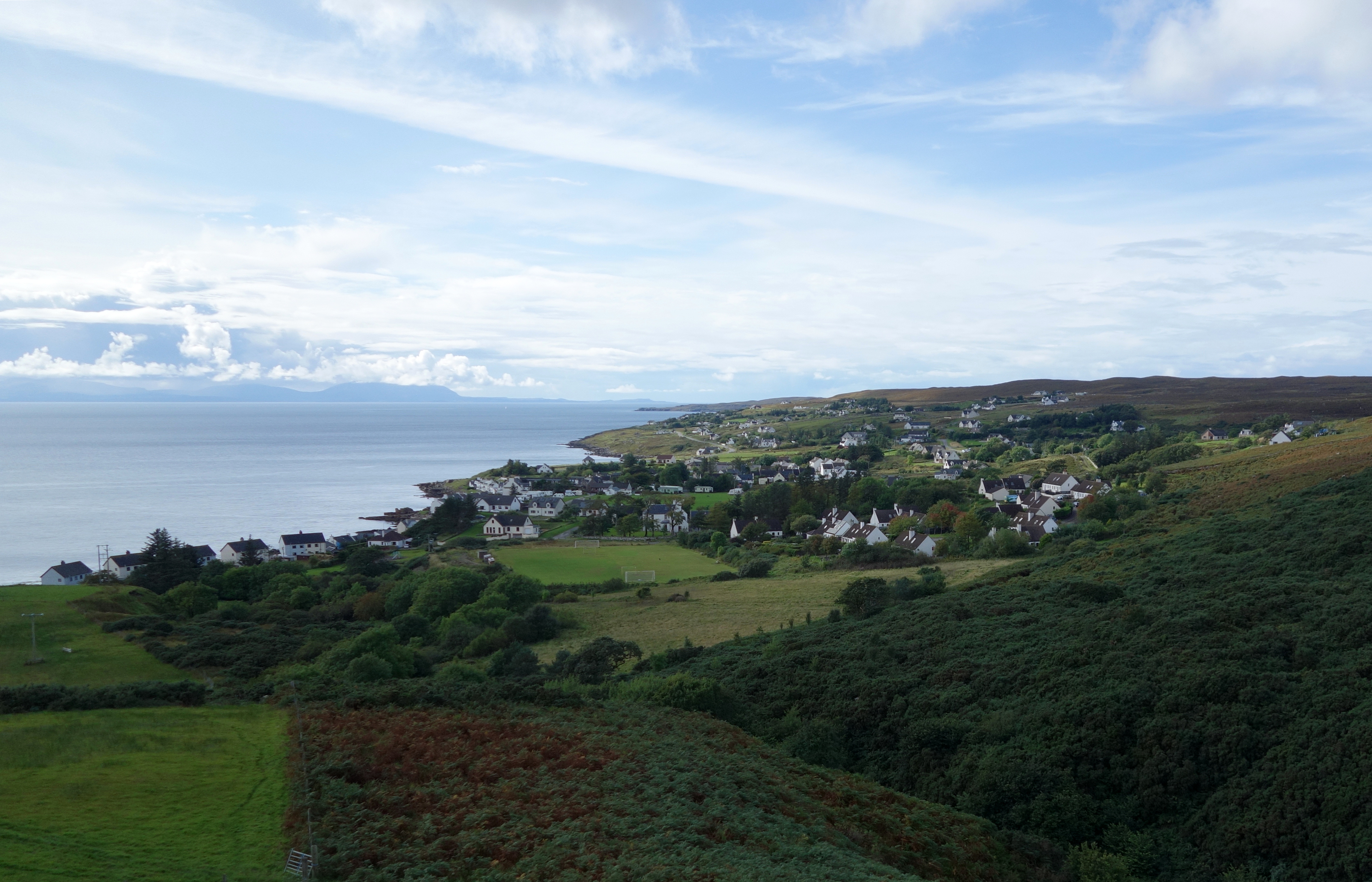
Auchtercairn is a small village located in the county of Ross-shire, Scotland. Situated in the picturesque Highlands region, it is nestled between the larger towns of Dingwall and Beauly. The village is known for its stunning natural beauty, with rolling hills, lush green fields, and breathtaking views of the surrounding countryside.

Auchtercairn is a close-knit community with a population of around 500 residents. Its peaceful and tranquil atmosphere attracts locals and visitors alike, offering a quiet retreat from the busier towns nearby. The village is predominantly residential, with a few small businesses catering to the needs of the local population.

The village is well-connected to the surrounding areas by road, making it easily accessible for those looking to explore the wider region. The nearby A832 road connects Auchtercairn to various towns and villages, providing convenient access to amenities and services.

Despite its small size, Auchtercairn offers a range of recreational activities for residents and visitors to enjoy. The surrounding countryside provides ample opportunities for hiking and walking, allowing visitors to immerse themselves in the natural beauty of the Highlands. Additionally, the village is a short drive away from the stunning Beauly Firth, where outdoor enthusiasts can indulge in fishing, birdwatching, and other water-based activities.

In summary, Auchtercairn is a charming village in Ross-shire, Scotland. With its idyllic location, friendly community, and access to natural wonders, it is a hidden gem for those seeking a peaceful retreat in the Highlands.

If you have any feedback on the listing, please let us know in the comments section below.

Auchtercairn Images

Images are sourced within 2km of 57.728425/-5.69219 or Grid Reference NG8076. Thanks to Geograph Open Source API. All images are credited.

Meall na Dubh Chlaise
Rough grazing at Lonemore
Strath: beach and coastal cottages
Meall na Dubh Chlaise The trig pillar on the summit of Meall na Dubh Chlaise & Strath Bay
Meall na Dubh Chlaise
The trig pillar on the summit of Meall na Dubh Chlaise & Strath Bay
Rocky summit A rocky flat top near to the summit of Meall na Dubh Chlaise.
Rocky summit
A rocky flat top near to the summit of Meall na Dubh Chlaise.
Torr Liath One of 4 very large rocks that look like they could roll down off Torr Liath at any time.  Sunset over Loch Gairloch and the Island of Rona.
Torr Liath
One of 4 very large rocks that look like they could roll down off Torr Liath at any time. Sunset over Loch Gairloch and the Island of Rona.
Gairloch campsite The busy campsite at Strath Gairloch.
Gairloch campsite
The busy campsite at Strath Gairloch.
Coastal scene along Loch Gairloch This scene is within the town of Gairloch, but at the western fringe. The setting is proximate to the Mountaineer Coffee Company.
Coastal scene along Loch Gairloch
This scene is within the town of Gairloch, but at the western fringe. The setting is proximate to the Mountaineer Coffee Company.
Village centre scene, Strath The road is the B8021, which ends a few miles north at Melvaig. The car park serves the few shops and cafes in the village.
Village centre scene, Strath
The road is the B8021, which ends a few miles north at Melvaig. The car park serves the few shops and cafes in the village.
The shore at Strath Viewed from the corner of the village car park, looking over the mouth of the Abhainn a' Mhuilinn.
The shore at Strath
Viewed from the corner of the village car park, looking over the mouth of the Abhainn a' Mhuilinn.
Millcroft Hotel, Strath The hotel stands on the corner of Mihol Road, and faces out over Strath Bay. The front of the building bears the date '1904' though the rear extension is clearly more modern. Some of the rooms in the hotel have been converted into self-catering accommodation.
Millcroft Hotel, Strath
The hotel stands on the corner of Mihol Road, and faces out over Strath Bay. The front of the building bears the date '1904' though the rear extension is clearly more modern. Some of the rooms in the hotel have been converted into self-catering accommodation.
Strath  Bay Looking over the slipway at Leac Mhor.
Strath Bay
Looking over the slipway at Leac Mhor.
Strath Fire St Tion Located in Mihol Road. I'm sure someone will put the 'A' back soon. The cut-open Nissan Micra in the compound suggests that some rescue training has been taking place recently. The keys were still in the ignition of the Micra, but I doubt anyone would be interested in stealing it now.
Strath Fire St Tion
Located in Mihol Road. I'm sure someone will put the 'A' back soon. The cut-open Nissan Micra in the compound suggests that some rescue training has been taking place recently. The keys were still in the ignition of the Micra, but I doubt anyone would be interested in stealing it now.
Shops and businesses in Strath Closest to the camera is Strath Stores - a general stores. The next building is a Bed and Breakfast, beyond (with red oval sign on the wall) is the Post Office, and beyond that a cafe/restaurant. The road is the B8021, which in this direction, ends a few miles to the north at Melvaig.
Shops and businesses in Strath
Closest to the camera is Strath Stores - a general stores. The next building is a Bed and Breakfast, beyond (with red oval sign on the wall) is the Post Office, and beyond that a cafe/restaurant. The road is the B8021, which in this direction, ends a few miles to the north at Melvaig.
Chapel in Strath Facing directly onto the B8021 road, the building on the left, with the black door, is Strath's Free Presbyterian Church of Scotland. Chapel sign detail: <a href="https://www.geograph.org.uk/photo/3266488">NG7977 : Chapel sign, Strath</a>. 
The building on the right was also a chapel when photographed by Mick Garratt in 2007 - <a href="https://www.geograph.org.uk/photo/532126">NG7977 : Chapels, Strath</a>. However, the chapel sign is now absent, and the building appears to now have a different use.
Chapel in Strath
Facing directly onto the B8021 road, the building on the left, with the black door, is Strath's Free Presbyterian Church of Scotland. Chapel sign detail: NG7977 : Chapel sign, Strath. The building on the right was also a chapel when photographed by Mick Garratt in 2007 - NG7977 : Chapels, Strath. However, the chapel sign is now absent, and the building appears to now have a different use.
Newsagent and Estate Agent, Strath Located alongside the B8021, The newsagents also sells toys and puzzles, arts, crafts and stationery, jewellery, greetings cards and fishing tackle. The small pink and brown striped building on the right is an ice cream parlour.
Newsagent and Estate Agent, Strath
Located alongside the B8021, The newsagents also sells toys and puzzles, arts, crafts and stationery, jewellery, greetings cards and fishing tackle. The small pink and brown striped building on the right is an ice cream parlour.
Butchers, Strath This is the premises of Kenneth Morrison Ltd, Butcher, Poulterer and Gamedealer. Fresh fruit and vegetables are also on offer. The road is the B8021, which in this direction end a few miles to the north at Melvaig.
Butchers, Strath
This is the premises of Kenneth Morrison Ltd, Butcher, Poulterer and Gamedealer. Fresh fruit and vegetables are also on offer. The road is the B8021, which in this direction end a few miles to the north at Melvaig.
Abhainn a' Mhuilinn The burn is pictured here flowing behind buildings in Strath village shortly before it enters the sea in Strath Bay.
Abhainn a' Mhuilinn
The burn is pictured here flowing behind buildings in Strath village shortly before it enters the sea in Strath Bay.
Show me another place!

Auchtercairn is located at Grid Ref: NG8076 (Lat: 57.728425, Lng: -5.69219)

Unitary Authority: Highland

Police Authority: Highlands and Islands

What 3 Words

///shepherds.buzzer.chew. Near Gairloch, Highland

Related Wikis

Gairloch High School

Gairloch High School (Gaelic: Àrd-Sgoil Gheàrrloch) is a six-year secondary school in Gairloch, Scotland. Being situated in a remote area of the Highlands...

Gairloch

Gairloch ( GAIR-lokh; Scottish Gaelic: Geàrrloch [ˈkʲaːrˠl̪ˠɔx], meaning "Short Loch") is a village, civil parish and community on the shores of Loch Gairloch...

Gairloch Museum

Gairloch Museum (Scottish Gaelic: Taigh-tasgaidh Gheàrrloch) is an independent museum in the Wester Ross region of Scotland. The museum is located in the...
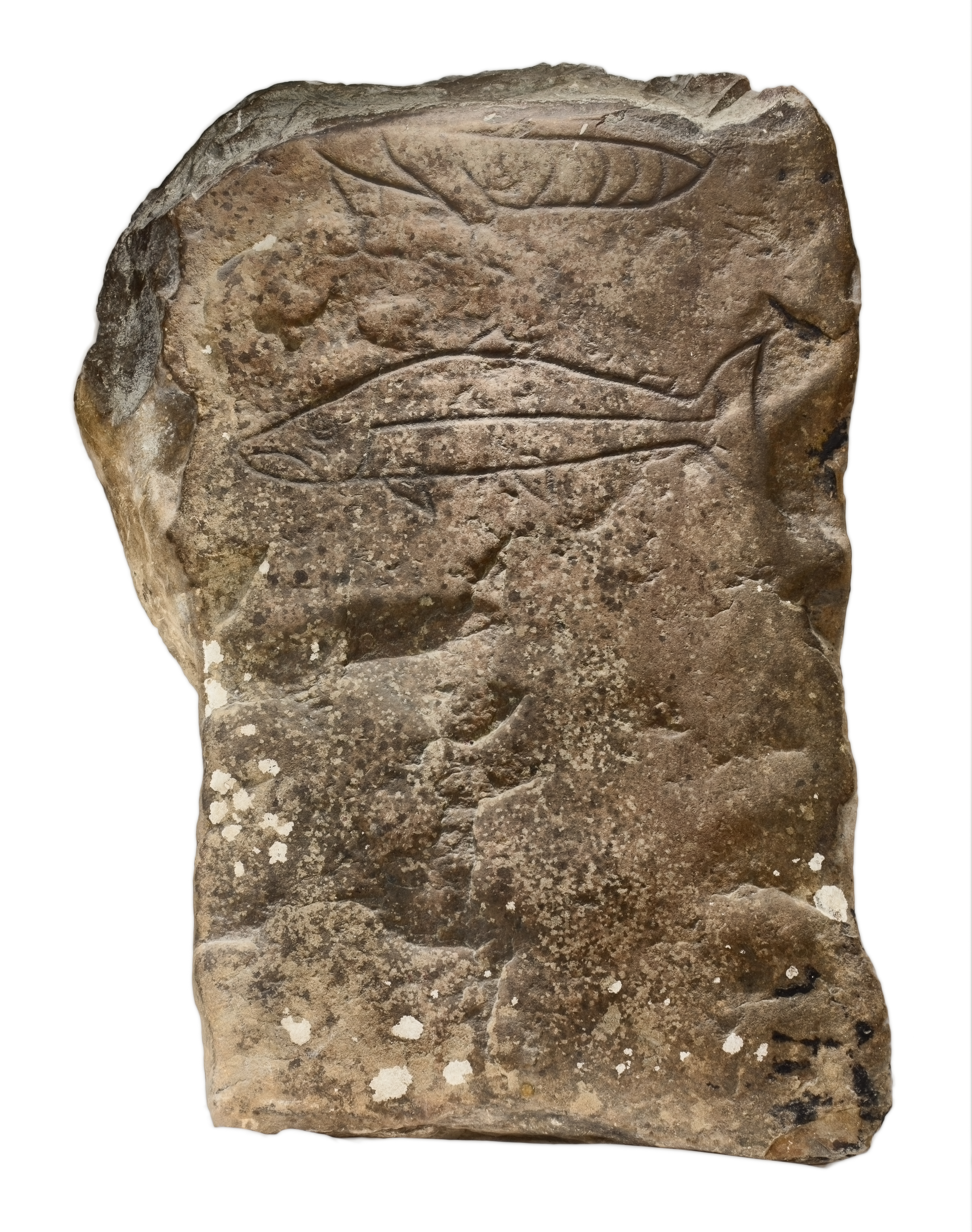
Gairloch Stone

The Gairloch Stone is a Class-I Pictish stone which was discovered at Achtercairn in Wester Ross around 1880. Subsequently, the stone was used as masonry...

Two Lochs Radio

Two Lochs Radio is Britain's smallest commercial radio station. It broadcasts a music-led service to the communities of Gairloch, Loch Ewe and Loch Maree...

Lonemore, Wester Ross

Lonemore (Scottish Gaelic: An Lòn Mòr) is a crofting village on the north shore of Gair Loch near the village of Gairloch, Ross-shire, Scottish Highlands...

An Ard

An Ard (Scottish Gaelic: ) is a collection of small settlements on the A832 road, close to Charlestown, in Gairloch, Ross-shire, on the east shore of Gair...

Charlestown, Wester Ross

Charlestown is a small hamlet, making up one of the settlements which are collectively called Gairloch, and located directly south of the main village...

Related Videos

2023- Windy Scotland 🏴󠁧󠁢󠁳󠁣󠁴󠁿💙🤍💙 #scotland #highlands #inspiration

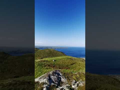
Achtercairn Path - Amazing trail for morning and evening hikes #hiking #trail.

We’ve arrived in Scotland to drive the NC500 in the Highlands #vanlife #scotland

The NC500 is a 516mile loop around the Scottish Highlands visiting all the sites you'd expect from this part of the world. #travel ...

North Coast 500 | Ardmair Beach to Victoria Falls

The drive up the West Coast of Scotland is amazing even with the wind and rain :) Our journey around Scotland's North Coast 500 ...

Unidentified whale seen off Scottish coast named after photographer who spotted it | SWNS #shorts

A wildlife photographer who spotted an unidentified humpback whale off the coast of Scotland has had it officially named after her.

Nearby Amenities

Located within 500m of 57.728425,-5.69219
Gairloch
Name Gd: Geàrrloch
Place: village
Population: 610
Wikidata: Q1442295
Wikipedia: en:Gairloch
Lat/Long: 57.7280125/-5.6903434
Gairloch Heritage Museum
Fee: yes
Name Gd: Taigh-tasgaidh Ghearrloch le Biadhlann
Source: survey
Tourism: museum
Wikidata: Q16838220
Wikipedia: en:Gairloch Museum
Lat/Long: 57.7256255/-5.6890501
Bus Stop
High School
Bench: yes
Naptan AtcoCode: 6700712695
Naptan Bearing: S
Naptan CommonName: High School
Naptan Indicator: o/s
Naptan Landmark: Gairloch High School
Naptan NaptanCode: 45328237
Naptan Street: School Car Park
Naptan Verified: no
Shelter: no
Source: naptan_import
Lat/Long: 57.7290386/-5.6921496
Bus Stop
Strath (Gairloch)
Naptan AtcoCode: 6700731986
Naptan Bearing: SW
Naptan CommonName: Strath (Gairloch)
Naptan Landmark: Post Office
Naptan NaptanCode: 45342349
Naptan Street: B8021
Naptan Verified: no
Source: naptan_import
Lat/Long: 57.7308962/-5.6991922
Achtercairn
Tourism: viewpoint
Lat/Long: 57.7323998/-5.6899505
Parking
Access: customers
Fee: no
Operator: MacRae
Operator Type: private
Parking: surface
Surface: asphalt
Lat/Long: 57.7274093/-5.6904865
Telephone
Booth: KX100
Covered: booth
Mapillary: 4597244753621591
Source: survey
Survey Date: 2019-08-17
Lat/Long: 57.7284295/-5.6919638
Post Box
Operator: Royal Mail
Operator Wikidata: Q638098
Post Box Mounting: pier
Post Box Type: lamp
Ref: IV21 224
Royal Cypher: scottish_crown
Source: survey
Lat/Long: 57.7273682/-5.6905807
Police
Source: survey
Lat/Long: 57.728166/-5.6909546
Atm
Lat/Long: 57.7279086/-5.6902286
Barrier: cattle_grid
Bicycle: yes
Foot: yes
Horse: yes
Motorcycle: yes
Lat/Long: 57.7287371/-5.6920595
Studio
Two Lochs Radio
Addr City: Gairloch
Addr Housename: Mansegate
Addr Postcode: IV21 2LR
Addr Street: Strath
Studio: radio
Type: Radio_station
Lat/Long: 57.7309627/-5.6991054
Post Office
Strath Post Office
Brand: Post Office
Brand Wikidata: Q1783168
Check Date: 2023-09-27
Operator: Morrisons Daily
Ref Pol Id: 127560
Lat/Long: 57.7278325/-5.6902286
Dentist
Gairloch Dental Practice
Healthcare: dentist
Lat/Long: 57.7292854/-5.6947993
PNL Accounting
Office: accountant
Lat/Long: 57.7292077/-5.6949689
Buddha by the Sea
Shop: gift
Lat/Long: 57.7304424/-5.6965839
Highland Council Service Point
Government: register_office
Office: government
Lat/Long: 57.7282346/-5.690921
Automatic Emergency Defibrillator
Defibrillator
Emergency: defibrillator
Indoor: no
Operator: Lucky2BHere
Lat/Long: 57.7285954/-5.6915419
Crossing
Crossing: uncontrolled
Crossing Island: no
Crossing Ref: zebra
Lat/Long: 57.7281813/-5.6914893
Veterinary
Conanvet
Lat/Long: 57.7269094/-5.6905418
Tourism: information
Lat/Long: 57.7324527/-5.6899923
College
UHI North, West and Hebrides - Gairloch Centre
Addr City: Gairloch
Addr Postcode: IV21 2BH
Addr Street: Achtercairn
Internet Access: yes
Internet Access Fee: customers
Name Gd: OGE a Tuath an Iar is Innse Gall - Geàrrloch
Operator: University of the Highlands and Islands
Operator Type: university
Lat/Long: 57.7256858/-5.6888992
Toilets
Public toilets
Lat/Long: 57.7286082/-5.691318
The Old Armory Guesthouse Self Catering
Internet Access: yes
Internet Access Fee: no
Tourism: guest_house
Lat/Long: 57.7273183/-5.6932326
Charging Station
EV charging point
Capacity: 43
Fee: no
Note: Free until 2020
Operator: ChargePlace Scotland
Operator Wikidata: Q105359316
Lat/Long: 57.7285952/-5.6916087
Ford: yes
Lat/Long: 57.7313425/-5.696403
Parking
Access: customers
Parking: surface
Lat/Long: 57.7256982/-5.689603
Bench
Lat/Long: 57.7259622/-5.688641
Colour: green
Height: 1
Man Made: street_cabinet
Operator: Openreach
Operator Wikidata: Q7096543
Ref: P2
Street Cabinet: telecom
Utility: telecom
Lat/Long: 57.7278423/-5.6899904
Recycling
Check Date Recycling: 2022-02-11
Recycling Clothes: yes
Recycling Glass Bottles: yes
Recycling Type: container
Lat/Long: 57.7286791/-5.6919392
Gairloch & District Times
Office: newspaper
Lat/Long: 57.7287433/-5.6918119
Power: pole
Lat/Long: 57.7324102/-5.689007
Power: pole
Lat/Long: 57.7321365/-5.6904677
Power: pole
Lat/Long: 57.7318467/-5.6919752
Power: pole
Lat/Long: 57.7314332/-5.6941469
Power: pole
Lat/Long: 57.7310735/-5.6960389
Power: pole
Lat/Long: 57.7315634/-5.6977393
Power: pole
Lat/Long: 57.7248161/-5.6871769
Material: wood
Power: pole
Lat/Long: 57.7254811/-5.6882625
Power: pole
Lat/Long: 57.7263028/-5.6884728
Power: pole
Lat/Long: 57.7264908/-5.6885249
Power: pole
Lat/Long: 57.7320758/-5.6885119
Power: pole
Lat/Long: 57.7294334/-5.6943263
Power: pole
Lat/Long: 57.7293677/-5.6945566
Power: pole
Lat/Long: 57.7285159/-5.6936733
Power: pole
Lat/Long: 57.7290589/-5.6941836
Power: pole
Lat/Long: 57.7297946/-5.6950447
Power: pole
Lat/Long: 57.7301684/-5.6955355
Power: pole
Lat/Long: 57.7305876/-5.6960576
Power: pole
Lat/Long: 57.7308133/-5.6970405
Power: pole
Lat/Long: 57.731062/-5.6981803
Power: pole
Lat/Long: 57.7312039/-5.6987627
Give Way
Direction: backward
Lat/Long: 57.7308717/-5.6989429
Give Way
Direction: backward
Lat/Long: 57.7283466/-5.6920869
Give Way
Direction: backward
Lat/Long: 57.7286844/-5.6945042
Parking
Access: customers
Fee: no
Parking: surface
Lat/Long: 57.7272725/-5.6902394
Give Way
Direction: backward
Lat/Long: 57.7260811/-5.6902978
The data included in this document is from www.openstreetmap.org. The data is made available under ODbL.

Have you been to Auchtercairn?

Leave your review of Auchtercairn below (or comments, questions and feedback).