South Walsham Plantation

Wood, Forest in Norfolk Broadland

England

South Walsham Plantation

View from St Helen's Church, Ranworth A good vantage point from which to admire the Norfolk Broads.
View from St Helen's Church, Ranworth Credit: David Bremner

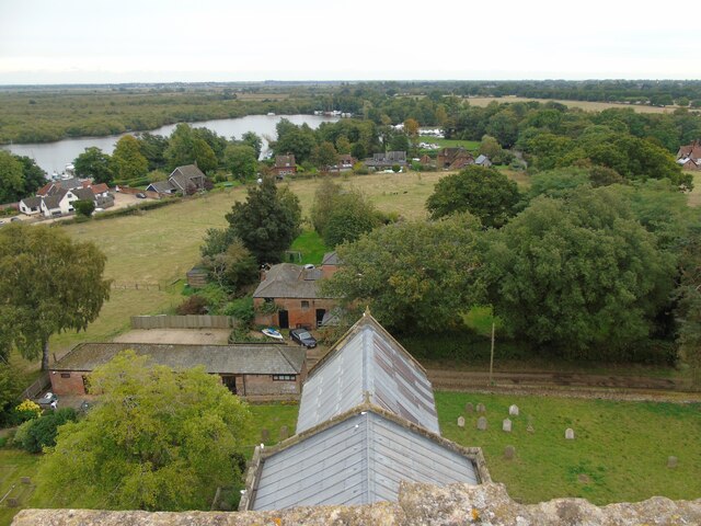
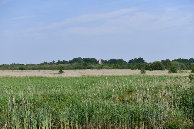
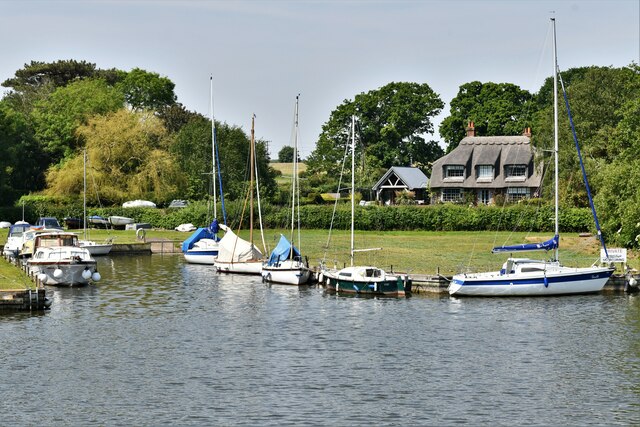
South Walsham Plantation is a picturesque woodland located in Norfolk, England. Spanning over a sprawling area, the plantation is known for its dense forest cover and diverse range of plant species. It is situated near the village of South Walsham and is a popular destination for nature enthusiasts and hikers.

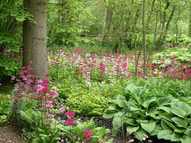
The woodland of South Walsham Plantation offers a serene and tranquil environment, providing a perfect escape from the hustle and bustle of city life. The forest is predominantly composed of deciduous trees, including oak, beech, and birch, which create a stunning canopy overhead. This variety of trees attracts a wide array of bird species, making it a haven for birdwatchers.

The plantation also boasts several well-maintained walking trails, allowing visitors to explore the natural beauty of the forest at their own pace. These trails are suitable for all levels of fitness and offer breathtaking views of the surrounding countryside. Along the way, visitors may come across charming streams, small ponds, and even the occasional wildflower meadow.

South Walsham Plantation is not only a paradise for nature lovers but also serves as an important habitat for various wildlife species. It is home to a diverse range of mammals, including deer, foxes, and badgers, as well as a multitude of insects and small creatures.

In conclusion, South Walsham Plantation in Norfolk is a stunning woodland retreat that offers a unique opportunity to connect with nature. With its tranquil atmosphere, diverse flora and fauna, and well-maintained walking trails, it is a must-visit destination for those seeking a peaceful and immersive natural experience.

If you have any feedback on the listing, please let us know in the comments section below.

South Walsham Plantation Images

Images are sourced within 2km of 52.668579/1.4979705 or Grid Reference TG3613. Thanks to Geograph Open Source API. All images are credited.

View from St Helen's Church, Ranworth A good vantage point from which to admire the Norfolk Broads.
View from St Helen's Church, Ranworth
A good vantage point from which to admire the Norfolk Broads.
Ranworth: St. Helen's Church from Ranworth Dam
Ranworth: Entrance to Ranworth Broad
Ranworth: Malthouse Broad and St. Helen's Church
Ranworth: Malthouse Broad
Ranworth: 'Private Dyke'
Ranworth, Malthouse Broad; Tower of  St. Helen's Church
Ranworth, Malthouse Broad; Tower of St. Helen's Church
Ranworth, Malthouse Broad: Moored boats
Ranworth, Malthouse Broad: Moored boats and slipway
Ranworth, Malthouse Broad: The Granary Restaurant
Ranworth: Boat on Malthouse Broad
Ranworth: Malthouse Broad and St. Helen's Church
Ranworth: Boat on Malthouse Broad
Ranworth, Malthouse Broad: Mooring
Show me another place!

South Walsham Plantation is located at Grid Ref: TG3613 (Lat: 52.668579, Lng: 1.4979705)

Administrative County: Norfolk

District: Broadland

Police Authority: Norfolk

What 3 Words

///gratitude.urgent.shunts. Near Horning, Norfolk

Related Wikis

Fairhaven Woodland and Water Garden

Fairhaven Woodland and Water Garden, Norfolk, England, is a registered charity, comprising 131 acres (0.53 km2) of ancient woodland, woodland garden and...

South Walsham

South Walsham is a village and civil parish in the English county of Norfolk. It covers an area of 11.43 km2 (4.41 sq mi) and had a population of 738 in...

Ranworth

Ranworth is a village in Norfolk, England in The Broads, adjacent to Malthouse Broad and Ranworth Broad. It is located in the civil parish of Woodbastwick...

Malthouse Broad

Malthouse Broad is a broad (i.e., lake) at Ranworth in the Norfolk Broads. The "Helen of Ranworth" is a traditional reedlighter, a boat that carried away...

Church of St Helen, Ranworth

The Church of St Helen, Ranworth, Norfolk is a church of medieval origins notable for its collection of church paintings. Known as "the cathedral of The...

Ranworth Broad

Ranworth Broad is a 136-hectare (340-acre) nature reserve on the Norfolk Broads north-east of Norwich in Norfolk, United Kingdom. It is managed by the...

South Walsham Fen

South Walsham Fen is a 1.4-hectare (3.5-acre) Local Nature Reserve west of South Walsham in Norfolk. It is owned and managed by Norfolk County Council...

Upton Fen

Upton Fen lies within The Broads National Park in Norfolk, England.It is a nature reserve in the care of Norfolk Wildlife Trust. Notable species found...

Nearby Amenities

Located within 500m of 52.668579,1.4979705
Bus Stop
Memorial Shelter, adj
Naptan AtcoCode: 2900W042
Naptan Bearing: SW
Naptan CommonName: Memorial Shelter
Naptan Indicator: adj
Naptan Landmark: Church Close
Naptan Locality: South Walsham
Naptan NaptanCode: nfogdapj
Naptan Street: The Street
Naptan Verified: yes
Shelter: yes
Source: naptan_import
Lat/Long: 52.6645333/1.4950979
Bus Stop
Memorial Shelter, opp
Naptan AtcoCode: 2900W046
Naptan Bearing: NE
Naptan CommonName: Memorial Shelter
Naptan Indicator: opp
Naptan Landmark: Church Close
Naptan Locality: South Walsham
Naptan NaptanCode: nfogdapt
Naptan Street: The Street
Naptan Verified: no
Source: naptan_import
Lat/Long: 52.6648971/1.4959572
Corner Cottage, adj
Naptan AtcoCode: 2900W048
Naptan Bearing: NW
Naptan BusStopType: CUS
Naptan CommonName: Corner Cottage
Naptan Indicator: adj
Naptan Landmark: Corner Cottage
Naptan Locality: South Walsham
Naptan NaptanCode: nfogdata
Naptan Street: Ranworth Road
Naptan Verified: no
Source: naptan_import
Lat/Long: 52.6651305/1.4944521
Corner Cottage, opp
Naptan AtcoCode: 2900W049
Naptan Bearing: SE
Naptan BusStopType: CUS
Naptan CommonName: Corner Cottage
Naptan Indicator: opp
Naptan Landmark: Corner Cottage
Naptan Locality: South Walsham
Naptan NaptanCode: nfogdatd
Naptan Street: Ranworth Road
Naptan Verified: no
Source: naptan_import
Lat/Long: 52.6650906/1.4945821
Fairhaven Gardens, adj
Naptan AtcoCode: 2900W050
Naptan Bearing: E
Naptan BusStopType: CUS
Naptan CommonName: Fairhaven Gardens
Naptan Indicator: adj
Naptan Landmark: Fairhaven Gardens
Naptan Locality: South Walsham
Naptan NaptanCode: nfogmpwa
Naptan Street: The Street
Naptan Verified: no
Source: naptan_import
Lat/Long: 52.6653241/1.4979442
Fairhaven Gardens, opp
Naptan AtcoCode: 2900W054
Naptan Bearing: W
Naptan BusStopType: CUS
Naptan CommonName: Fairhaven Gardens
Naptan Indicator: opp
Naptan Landmark: Fairhaven Gardens
Naptan Locality: South Walsham
Naptan NaptanCode: nfogmpwd
Naptan Street: The Street
Naptan Verified: no
Source: naptan_import
Lat/Long: 52.6651882/1.4979777
Toilets
Access: customers
Lat/Long: 52.6658571/1.5016557
Waste Basket
Check Date: 2021-06-04
Waste: dog_excrement
Lat/Long: 52.6655596/1.5019077
Entrance: yes
Lat/Long: 52.6654435/1.4973312
Entrance: main
Lat/Long: 52.6654447/1.497185
Entrance: main
Lat/Long: 52.66528/1.4964477
Location Transition: yes
Power: pole
Transformer: distribution
Lat/Long: 52.6696813/1.5045691
Give Way
Lat/Long: 52.6646134/1.5004617
Fairhaven Woodland & Water Garden
Garden Type: botanical
Leisure: garden
Lat/Long: 52.6657017/1.5022944
Power: pole
Lat/Long: 52.664231/1.4987795
Power: pole
Transformer: distribution
Lat/Long: 52.6646984/1.4993041
South Walsham
Board Type: notice
Information: board
Tourism: information
Lat/Long: 52.6645515/1.4951706
Waste Basket
Colour: red
Waste: dog_excrement
Lat/Long: 52.6645437/1.4951432
Waste Basket
Colour: green
Waste: trash
Lat/Long: 52.6645419/1.4951294
Post Box
Check Date Collection Times: 09/04/2020
Collection Times: Mo-Fr 16:15; Sa 11:30
Note: Priority postbox
Operator: Royal Mail
Operator Wikidata: Q638098
Post Box Mounting: pier
Post Box Type: lamp
Ref: NR13 1375
Royal Cypher: EIIR
Royal Cypher Wikidata: Q33102113
Lat/Long: 52.664541/1.4950558
Give Way
Lat/Long: 52.664552/1.4948366
The data included in this document is from www.openstreetmap.org. The data is made available under ODbL.

Have you been to South Walsham Plantation?

Leave your review of South Walsham Plantation below (or comments, questions and feedback).