Whitmore Wood

Wood, Forest in Suffolk East Suffolk

England

Whitmore Wood

Road junction to Campsea Ashe on Ash Road
Road junction to Campsea Ashe on Ash Road Credit: Adrian S Pye

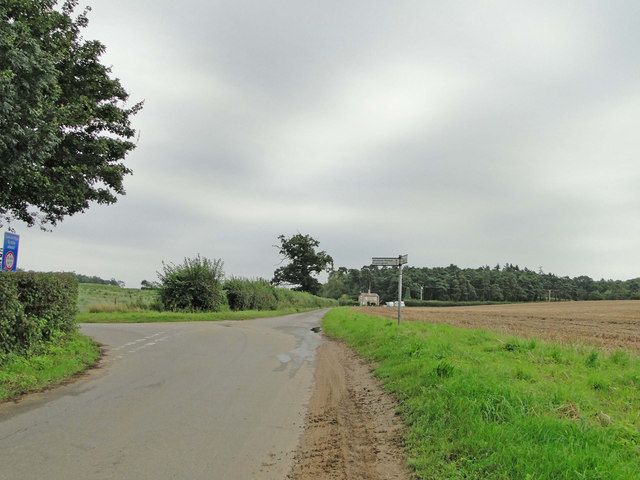
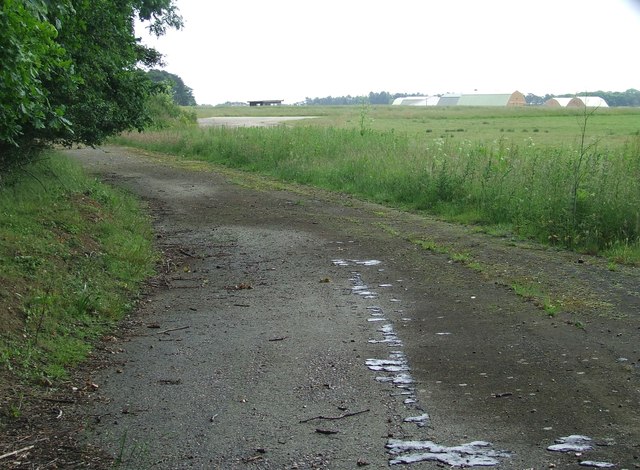
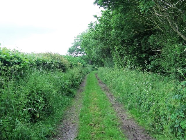
Whitmore Wood, located in Suffolk, England, is a picturesque and enchanting woodland area that covers approximately 100 acres of land. It is part of the larger and well-known Suffolk Wildlife Trust and is situated near the village of Whitmore, hence its name.

The wood is characterized by its diverse range of trees, including oak, beech, birch, and holly, which create a dense and vibrant canopy. These trees provide a habitat for numerous bird species, such as blackbirds, woodpeckers, and tawny owls, making it a haven for birdwatchers and nature enthusiasts alike.

Within Whitmore Wood, there are several well-maintained footpaths and trails that allow visitors to explore its natural beauty. These paths wind through the wood, offering glimpses of wildflowers, ferns, and other native plant species that thrive in the woodland environment. The wood also boasts a tranquil pond, which adds to its appeal and provides a serene spot for reflection.

The Suffolk Wildlife Trust actively manages Whitmore Wood to preserve its unique ecosystem. This includes regular maintenance of the footpaths, as well as the selective thinning of trees to promote the growth of new saplings. Conservation efforts are also in place to protect the various species of flora and fauna that call the wood home.

Whether it's for a leisurely walk, birdwatching, or simply enjoying the beauty of nature, Whitmore Wood offers a peaceful and idyllic escape for visitors seeking a connection with the natural world.

If you have any feedback on the listing, please let us know in the comments section below.

Whitmore Wood Images

Images are sourced within 2km of 52.127652/1.4219279 or Grid Reference TM3453. Thanks to Geograph Open Source API. All images are credited.

Road junction to Campsea Ashe on Ash Road
War Memorial & Roll of Honour in Rendlesham St. Gregory The Roll of Honour can be seen in greater detail here > <a title="https://www.geograph.org.uk/photo/4409370" href="https://www.geograph.org.uk/photo/4409370">Link</a>
War Memorial & Roll of Honour in Rendlesham St. Gregory
The Roll of Honour can be seen in greater detail here > Link
Inside St Gregory's Church The clear glass and the grey gloss paint on the pews give the interior a light airy feel.  The fantastic decorated tracery in the east window is Georgian work of 1783 and made of wood, but the communion rails are from the 17th century.
Inside St Gregory's Church
The clear glass and the grey gloss paint on the pews give the interior a light airy feel. The fantastic decorated tracery in the east window is Georgian work of 1783 and made of wood, but the communion rails are from the 17th century.
Lest we Forget A display for the centenary of the Great War in the priest's doorway at St Gregory's Church.
Lest we Forget
A display for the centenary of the Great War in the priest's doorway at St Gregory's Church.
Grinning lion One of eight (four around the stem and four on the bowl) surrounding the font in St Gregory's Church.
Grinning lion
One of eight (four around the stem and four on the bowl) surrounding the font in St Gregory's Church.
Part of the former USAF Bentwaters Looking through an old gate of USAF Bentwaters near to Rendlesham, Suffolk.
Part of the former USAF Bentwaters
Looking through an old gate of USAF Bentwaters near to Rendlesham, Suffolk.
Footpath Footpath looking east near to Campsea Ashe, Suffolk.
Footpath
Footpath looking east near to Campsea Ashe, Suffolk.
Walnut Tree Avenue Walnut Tree Avenue Rendlesham, Suffolk.
Walnut Tree Avenue
Walnut Tree Avenue Rendlesham, Suffolk.
Garden Square Looking along Garden Square Rendlesham, Suffolk.
Garden Square
Looking along Garden Square Rendlesham, Suffolk.
St.Gregory the Great, Rendlesham: late December 2016
Cut Mark Rendlesham RAF Bentwaters Control Tower Cut Mark Rendlesham RAF Bentwaters Control Tower, W angle (building 61.)
Cut Mark Rendlesham RAF Bentwaters Control Tower
Cut Mark Rendlesham RAF Bentwaters Control Tower, W angle (building 61.)
RAF Bentwaters Building 661 Police Dog Kennels RAF Bentwaters Building 661 Police Dog Kennels
RAF Bentwaters Building 661 Police Dog Kennels
RAF Bentwaters Missile Shop RAF Bentwaters Missile Shop.
.
RAF Bentwaters Missile Shop
RAF Bentwaters Missile Shop. .
RAF Bentwaters Building 560 Hardened Security Shelter RAF Bentwaters Building 560 Hardened Security Shelter
RAF Bentwaters Building 560 Hardened Security Shelter
RAF Bentwaters Building 659 Nissen Type Structure RAF Bentwaters Building 659 Nissen Type Structure
RAF Bentwaters Building 659 Nissen Type Structure
RAF Bentwaters Building 1681 92nd TFS Flight Office RAF Bentwaters Building 1681 92nd TFS Flight Office
RAF Bentwaters Building 1681 92nd TFS Flight Office
RAF Bentwaters Building 1680 92nd TFS Office RAF Bentwaters Building 1680 92nd TFS Office.
RAF Bentwaters Building 1680 92nd TFS Office
RAF Bentwaters Building 1680 92nd TFS Office.
RAF Bentwaters Building 1679 92nd Weapon Shop RAF Bentwaters Building 1679 92nd Weapon Shop.
RAF Bentwaters Building 1679 92nd Weapon Shop
RAF Bentwaters Building 1679 92nd Weapon Shop.
Show me another place!

Whitmore Wood is located at Grid Ref: TM3453 (Lat: 52.127652, Lng: 1.4219279)

Administrative County: Suffolk

District: East Suffolk

Police Authority: Suffolk

What 3 Words

///remedy.shelving.caressed. Near Rendlesham, Suffolk

Related Wikis

Rendlesham

Rendlesham is a village and civil parish near Woodbridge, Suffolk, United Kingdom. It was a royal centre of authority for the king of the East Angles....

Rendlesham Hall

Rendlesham Hall was a large manor house in the village of Rendlesham in Suffolk. == History == The hall was built in the pointed style in 1780 and two...

RAF Bentwaters

Royal Air Force Bentwaters or more simply RAF Bentwaters, now known as Bentwaters Parks, is a former Royal Air Force station about 80 miles (130 km) northeast...

Tunstall, Suffolk

On an Ordnance Survey map of Suffolk, England, there are two settlements named Tunstall next to each other, 7.5 miles (12.1 km) north east of Woodbridge...

Sandlings Forest

Sandlings Forest is a 2,483.8 hectare biological Site of Special Scientific Interest in two large blocks, Rendlesham Forest and Tunstall Forest, and two...

Campsey Priory

Campsey Priory, (Campesse, Kampessie, etc.), was a religious house of Augustinian canonesses at Campsea Ashe, Suffolk, about 1.5 miles (2.5 km) south east...

Campsea Ashe

Campsea Ashe (sometimes spelt Campsey Ash) is a village in Suffolk, England located approximately 5 miles (8 km) north east of Woodbridge and 6 miles...

Wickham Market railway station

Wickham Market railway station is on the East Suffolk Line in the east of England, located in Campsea Ashe, Suffolk, approximately 2 miles (3.2 km) east...

Nearby Amenities

Located within 500m of 52.127652,1.4219279
Bus Stop
Bentwaters Coach Stop
Bus: yes
Naptan AtcoCode: 390060112
Naptan Bearing: SW
Naptan CommonName: Bentwaters Coach Stop
Naptan Indicator: o/s
Naptan Landmark: Bentwaters Coach Stop
Naptan NaptanCode: sufgmtag
Naptan Street: A1152
Naptan Verified: no
Public Transport: platform
Shelter: no
Source: naptan_import
Lat/Long: 52.1279752/1.4184863
Bus Stop
Sparrows Croft
Bus: yes
Naptan AtcoCode: 390060159
Naptan Bearing: SE
Naptan CommonName: Sparrows Croft
Naptan Indicator: adj
Naptan Landmark: Sparrows Croft
Naptan NaptanCode: sufgmtwt
Naptan Street: Redwald Road
Naptan Verified: no
Public Transport: platform
Source: naptan_import
Lat/Long: 52.1314251/1.4184684
Sparrows Croft
Naptan AtcoCode: 390060160
Naptan Bearing: NW
Naptan BusStopType: CUS
Naptan CommonName: Sparrows Croft
Naptan Indicator: opp
Naptan Landmark: Sparrows Croft
Naptan NaptanCode: sufgmwad
Naptan Street: Redwald Road
Naptan Verified: no
Source: naptan_import
Lat/Long: 52.1315042/1.418533
Bus Stop
Magnolia Drive
Bus: yes
Naptan AtcoCode: 390061136
Naptan Bearing: NE
Naptan CommonName: Magnolia Drive
Naptan Indicator: opp
Naptan Landmark: Magnolia Drive
Naptan NaptanCode: sufjtdmg
Naptan Street: Acer Road
Naptan Verified: no
Public Transport: platform
Source: naptan_import
Lat/Long: 52.1292997/1.416391
Bus Stop
Magnolia Drive
Bus: yes
Naptan AtcoCode: 390061137
Naptan Bearing: SW
Naptan BusStopType: CUS
Naptan CommonName: Magnolia Drive
Naptan Indicator: adj
Naptan Landmark: Magnolia Drive
Naptan NaptanCode: sufjtdmj
Naptan Street: Acer Road
Naptan Verified: no
Public Transport: platform
Source: naptan_import
Lat/Long: 52.1294114/1.4168819
Bus Stop
Sycamore Drive
Bus: yes
Naptan AtcoCode: 390061138
Naptan Bearing: NE
Naptan BusStopType: CUS
Naptan CommonName: Sycamore Drive
Naptan Indicator: adj
Naptan Landmark: Sycamore Drive
Naptan NaptanCode: sufjtdmp
Naptan Street: Acer Road
Naptan Verified: no
Public Transport: platform
Source: naptan_import
Lat/Long: 52.1308209/1.4188155
Bus Stop
Sycamore Drive
Bus: yes
Naptan AtcoCode: 390061139
Naptan Bearing: SW
Naptan BusStopType: CUS
Naptan CommonName: Sycamore Drive
Naptan Indicator: opp
Naptan Landmark: Sycamore Drive
Naptan NaptanCode: sufjtdmt
Naptan Street: Acer Road
Naptan Verified: no
Public Transport: platform
Source: naptan_import
Lat/Long: 52.1305482/1.4186205
Crossing
Lat/Long: 52.129401/1.420655
Post Box
Collection Times: Mo-Fr 16:45; Sa 09:00
Post Box Type: pillar
Ref: IP12 8220
Royal Cypher: EIIR
Royal Cypher Wikidata: Q33102113
Lat/Long: 52.1276566/1.4270035
Post Box
Brand: Royal Mail
Brand Wikidata: Q638098
Collection Times: Mo-Fr 16:45; Sa 10:00
Operator: Royal Mail
Operator Wikidata: Q638098
Post Box Type: lamp
Ref: IP12 6296
Royal Cypher: EIIR
Royal Cypher Wikidata: Q33102113
Lat/Long: 52.1310209/1.4197999
Generator Method: photovoltaic
Generator Output Electricity: yes
Generator Source: solar
Generator Type: solar_photovoltaic_panel
Location: roof
Power: generator
Lat/Long: 52.1294254/1.4279236
Generator Method: photovoltaic
Generator Output Electricity: yes
Generator Source: solar
Generator Type: solar_photovoltaic_panel
Location: roof
Power: generator
Lat/Long: 52.1286506/1.4161393
Generator Method: photovoltaic
Generator Output Electricity: yes
Generator Source: solar
Generator Type: solar_photovoltaic_panel
Location: roof
Power: generator
Lat/Long: 52.1285189/1.4159435
Generator Method: photovoltaic
Generator Output Electricity: yes
Generator Source: solar
Generator Type: solar_photovoltaic_panel
Location: roof
Power: generator
Lat/Long: 52.1288235/1.4222386
Generator Method: photovoltaic
Generator Output Electricity: yes
Generator Source: solar
Generator Type: solar_photovoltaic_panel
Location: roof
Power: generator
Lat/Long: 52.1292961/1.4209539
Generator Method: photovoltaic
Generator Output Electricity: yes
Generator Source: solar
Generator Type: solar_photovoltaic_panel
Location: roof
Power: generator
Lat/Long: 52.129581/1.4205569
Generator Method: photovoltaic
Generator Output Electricity: yes
Generator Source: solar
Generator Type: solar_photovoltaic_panel
Location: roof
Power: generator
Lat/Long: 52.1299119/1.4207634
Generator Method: photovoltaic
Generator Output Electricity: yes
Generator Source: solar
Generator Type: solar_photovoltaic_panel
Location: roof
Power: generator
Lat/Long: 52.129716/1.4177808
Generator Method: photovoltaic
Generator Output Electricity: yes
Generator Source: solar
Generator Type: solar_photovoltaic_panel
Location: roof
Power: generator
Lat/Long: 52.130787/1.4172752
Generator Method: photovoltaic
Generator Output Electricity: yes
Generator Source: solar
Generator Type: solar_photovoltaic_panel
Location: roof
Power: generator
Lat/Long: 52.1304289/1.4167106
Generator Method: photovoltaic
Generator Output Electricity: yes
Generator Source: solar
Generator Type: solar_photovoltaic_panel
Location: roof
Power: generator
Lat/Long: 52.1303054/1.4166194
Generator Method: photovoltaic
Generator Output Electricity: yes
Generator Source: solar
Generator Type: solar_photovoltaic_panel
Location: roof
Power: generator
Lat/Long: 52.1317379/1.4212999
Generator Method: photovoltaic
Generator Output Electricity: yes
Generator Source: solar
Generator Type: solar_photovoltaic_panel
Location: roof
Power: generator
Lat/Long: 52.131705/1.4213803
Generator Method: photovoltaic
Generator Output Electricity: yes
Generator Source: solar
Generator Type: solar_photovoltaic_panel
Location: roof
Power: generator
Lat/Long: 52.1310431/1.4216593
Generator Method: photovoltaic
Generator Output Electricity: yes
Generator Source: solar
Generator Type: solar_photovoltaic_panel
Location: roof
Power: generator
Lat/Long: 52.1309953/1.4222494
Generator Method: photovoltaic
Generator Output Electricity: yes
Generator Source: solar
Generator Type: solar_photovoltaic_panel
Location: roof
Power: generator
Lat/Long: 52.1298897/1.4214689
Generator Method: photovoltaic
Generator Output Electricity: yes
Generator Source: solar
Generator Type: solar_photovoltaic_panel
Location: roof
Power: generator
Lat/Long: 52.129632/1.4223406
Generator Method: photovoltaic
Generator Output Electricity: yes
Generator Source: solar
Generator Type: solar_photovoltaic_panel
Location: roof
Power: generator
Lat/Long: 52.1298773/1.4229467
Generator Method: photovoltaic
Generator Output Electricity: yes
Generator Source: solar
Generator Type: solar_photovoltaic_panel
Location: roof
Power: generator
Lat/Long: 52.1296271/1.4223996
Generator Method: photovoltaic
Generator Output Electricity: yes
Generator Source: solar
Generator Type: solar_photovoltaic_panel
Location: roof
Power: generator
Lat/Long: 52.1303054/1.4211953
Generator Method: photovoltaic
Generator Output Electricity: yes
Generator Source: solar
Generator Type: solar_photovoltaic_panel
Location: roof
Power: generator
Lat/Long: 52.130065/1.4219007
Generator Method: photovoltaic
Generator Output Electricity: yes
Generator Source: solar
Generator Type: solar_photovoltaic_panel
Location: roof
Power: generator
Lat/Long: 52.1300025/1.4219597
Generator Method: photovoltaic
Generator Output Electricity: yes
Generator Source: solar
Generator Type: solar_photovoltaic_panel
Location: roof
Power: generator
Lat/Long: 52.1305837/1.4218202
Generator Method: photovoltaic
Generator Output Electricity: yes
Generator Source: solar
Generator Type: solar_photovoltaic_panel
Location: roof
Power: generator
Lat/Long: 52.1306298/1.4219999
Generator Method: photovoltaic
Generator Output Electricity: yes
Generator Source: solar
Generator Type: solar_photovoltaic_panel
Location: roof
Power: generator
Lat/Long: 52.1304536/1.4229789
Generator Method: photovoltaic
Generator Output Electricity: yes
Generator Source: solar
Generator Type: solar_photovoltaic_panel
Location: roof
Power: generator
Lat/Long: 52.1303515/1.4230755
The data included in this document is from www.openstreetmap.org. The data is made available under ODbL.

Have you been to Whitmore Wood?

Leave your review of Whitmore Wood below (or comments, questions and feedback).