Mansbrook Grove

Wood, Forest in Suffolk East Suffolk

England

Mansbrook Grove

Woolverstone Marina
Woolverstone Marina Credit: Chris Holifield

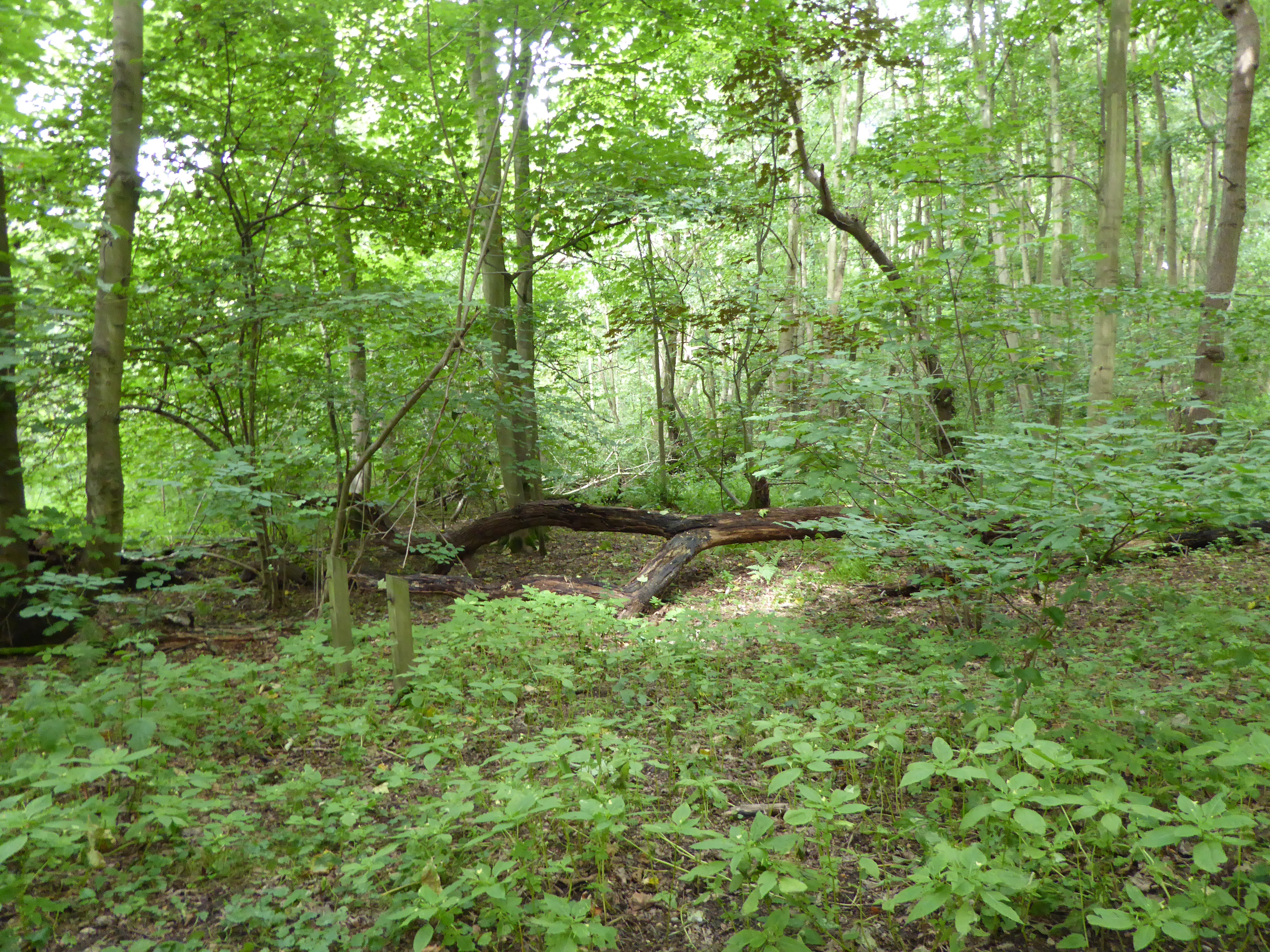
Mansbrook Grove is a serene and picturesque woodland located in Suffolk, England. Nestled amidst the rolling countryside, this enchanting forest spans over a vast area, providing a haven for nature lovers and outdoor enthusiasts alike.

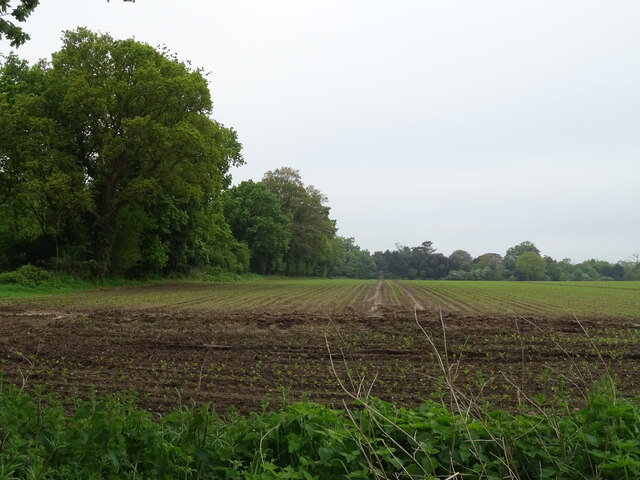
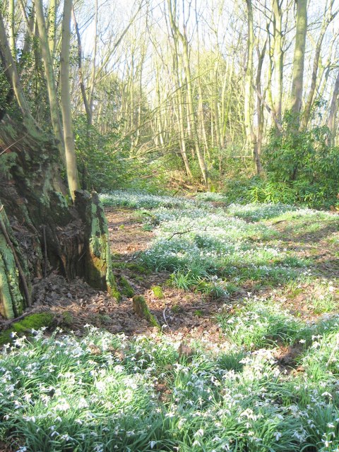
The grove is characterized by its dense canopy of towering trees, predominantly consisting of native species such as oak, beech, and birch. These majestic trees create a tranquil and shaded atmosphere, offering a respite from the hustle and bustle of everyday life. The forest floor is adorned with a rich carpet of vibrant wildflowers, adding a burst of color to the landscape.

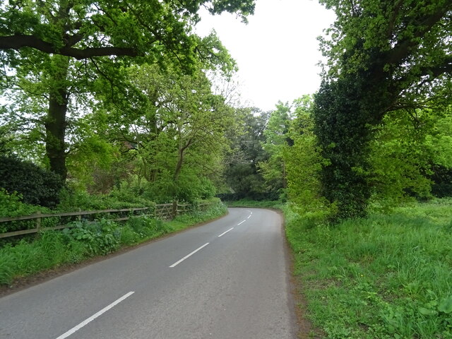
Within Mansbrook Grove, a network of well-maintained pathways meanders through the woodland, providing visitors with the opportunity to explore and immerse themselves in the natural beauty of the surroundings. Along these trails, one may encounter an array of wildlife, including squirrels, rabbits, and a variety of bird species, making it an ideal spot for birdwatching and wildlife enthusiasts.

The grove also boasts a small, meandering stream that adds to the charm of the woodland. The gentle babble of the water creates a soothing soundtrack, enhancing the overall tranquility of the area. Visitors can take advantage of the numerous picnic spots scattered throughout the grove, allowing for a peaceful lunch or snack amidst the natural splendor.

Mansbrook Grove is a true gem in Suffolk, offering a serene and enchanting escape surrounded by the beauty of nature. Whether it be for a leisurely stroll, birdwatching, or simply enjoying a moment of solitude, this woodland is a must-visit destination for those seeking solace in the great outdoors.

If you have any feedback on the listing, please let us know in the comments section below.

Mansbrook Grove Images

Images are sourced within 2km of 52.015825/1.1996507 or Grid Reference TM1940. Thanks to Geograph Open Source API. All images are credited.

Woolverstone Marina
Woolverstone Marina
Crop field beside woodland
Bend in National Cycle Route 51 Ipswich Road towards Nacton.
Bend in National Cycle Route 51
Ipswich Road towards Nacton.
Woolverstone Marina Wolverstone Marina is the Home of many pleasure crafts.  It is also next to the “Cat House” where it was said that years ago was the home to a man who was sympathetic to boats carrying contraband along the river.  He had a pet cat which he loved.  When it died he had it stuffed and when he could see that no customs boats were patrolling the river put the cat in the window for any smugglers to see, signalling that all was well.
Woolverstone Marina
Wolverstone Marina is the Home of many pleasure crafts. It is also next to the “Cat House” where it was said that years ago was the home to a man who was sympathetic to boats carrying contraband along the river. He had a pet cat which he loved. When it died he had it stuffed and when he could see that no customs boats were patrolling the river put the cat in the window for any smugglers to see, signalling that all was well.
A long drive Woolverstone Hall Woolverstone Suffolk.Now a school. More info see <span class="nowrap"><a title="http://en.wikipedia.org/wiki/Woolverstone_Hall" rel="nofollow ugc noopener" href="http://en.wikipedia.org/wiki/Woolverstone_Hall">Link</a><img style="margin-left:2px;" alt="External link" title="External link - shift click to open in new window" src="https://s1.geograph.org.uk/img/external.png" width="10" height="10"/></span>
A long drive
Woolverstone Hall Woolverstone Suffolk.Now a school. More info see LinkExternal link
Snowdrops in Woolverstone wood
St Michael's, Woolverstone Taken from the drive down to the marina.
St Michael's, Woolverstone
Taken from the drive down to the marina.
Foreshore at Woolverstone Looking upstream from the end of the public footpath towards the Orwell Bridge.
Foreshore at Woolverstone
Looking upstream from the end of the public footpath towards the Orwell Bridge.
Cottage in a clearing Sympathetically extended cottage in a clearing in Woolverstone Woods.
Cottage in a clearing
Sympathetically extended cottage in a clearing in Woolverstone Woods.
Woolverstone Marina Mdl owned Marina on the River Orwell
Woolverstone Marina
Mdl owned Marina on the River Orwell
River Orwell saltmarsh An area of saltmarsh at Freston, on the west bank of the River Orwell. The areas of saltmarsh - or 'saltings' - in the river have eroded considerably in recent decades. This may be partly due to the effect of wash from larger vessels using the port of Ipswich.
River Orwell saltmarsh
An area of saltmarsh at Freston, on the west bank of the River Orwell. The areas of saltmarsh - or 'saltings' - in the river have eroded considerably in recent decades. This may be partly due to the effect of wash from larger vessels using the port of Ipswich.
River Orwell foreshore On the Freston foreshore the saltings have eroded, leaving only remnants of slightly harder soil. These apparent 'rocks' are in fact lumps of hardened mud, which will probably disappear in time.
River Orwell foreshore
On the Freston foreshore the saltings have eroded, leaving only remnants of slightly harder soil. These apparent 'rocks' are in fact lumps of hardened mud, which will probably disappear in time.
River Orwell tributary This unnamed stream enters the River Orwell from Freston Park.
River Orwell tributary
This unnamed stream enters the River Orwell from Freston Park.
Freston Park The parkland extends to the river bank, by the line of gorse bushes. The River Orwell and the Orwell Bridge can be seen in the distance.
Freston Park
The parkland extends to the river bank, by the line of gorse bushes. The River Orwell and the Orwell Bridge can be seen in the distance.
Freston Park and Tower The parkland surrounds the tower and neighbouring farmhouse. The folly is owned by the Landmark Trust, and is rented out as one of their more unusual properties.
Freston Park and Tower
The parkland surrounds the tower and neighbouring farmhouse. The folly is owned by the Landmark Trust, and is rented out as one of their more unusual properties.
Riverbank tree This dead tree is on the bank of the River Orwell, below Freston Tower, which can be seen behind the gorse bushes.
Riverbank tree
This dead tree is on the bank of the River Orwell, below Freston Tower, which can be seen behind the gorse bushes.
River Orwell transit beacon The beacon used to be much larger, and higher, and acted as a transit against Freston Tower on the hillside behind. It was used before the Orwell was dredged and straightened and enabled sailing vessels to steer the right course on the then tortuous journey upstream to Ipswich.
River Orwell transit beacon
The beacon used to be much larger, and higher, and acted as a transit against Freston Tower on the hillside behind. It was used before the Orwell was dredged and straightened and enabled sailing vessels to steer the right course on the then tortuous journey upstream to Ipswich.
Freston Park Looking over to the River Orwell from below Freston Tower.
Freston Park
Looking over to the River Orwell from below Freston Tower.
Show me another place!

Mansbrook Grove is located at Grid Ref: TM1940 (Lat: 52.015825, Lng: 1.1996507)

Administrative County: Suffolk

District: East Suffolk

Police Authority: Suffolk

What 3 Words

///hubcaps.verbs.nimbly. Near Holbrook, Suffolk

Related Wikis

Alnesbourne Priory

Alnesbourne Priory, also known as Alnesbourn Priory, was a small Augustinian monastic house in the English county of Suffolk. It was located near Nacton...

Bridge Wood

Bridge Wood is a 31 hectare Local Nature Reserve on the southern outskirts of Ipswich in Suffolk, England. It is owned and managed by Ipswich Borough Council...

Ipswich High School, Suffolk

Ipswich High School is a co-educational private school at Woolverstone Hall near Ipswich, England. Formerly an exclusive school for girls, it was converted...

Woolverstone Hall School

In the early 1950s the London County Council obtained use of Woolverstone Hall near Ipswich, Suffolk, and some 50 acres (200,000 m2) of adjoining land...

Nearby Amenities

Located within 500m of 52.015825,1.1996507
Created By: almien_coastlines
Source: PGS
Lat/Long: 52.0152547/1.1927449
Created By: almien_coastlines
Source: PGS
Lat/Long: 52.0153467/1.193713
Source: PGS
Lat/Long: 52.0152661/1.1944744
Source: PGS
Lat/Long: 52.0150896/1.1971052
Source: PGS
Lat/Long: 52.0153958/1.1965101
Source: PGS
Lat/Long: 52.0154351/1.1976964
Source: PGS
Lat/Long: 52.0150216/1.1995898
Source: PGS
Lat/Long: 52.0149012/1.2002359
Source: PGS
Lat/Long: 52.0149557/1.2004255
Source: PGS
Lat/Long: 52.0146718/1.2006229
Source: PGS
Lat/Long: 52.0140228/1.2018012
Source: PGS
Lat/Long: 52.0135994/1.202887
Source: PGS
Lat/Long: 52.0133992/1.2036249
Source: PGS
Lat/Long: 52.0131507/1.2049767
The data included in this document is from www.openstreetmap.org. The data is made available under ODbL.

Have you been to Mansbrook Grove?

Leave your review of Mansbrook Grove below (or comments, questions and feedback).