Lady Belt

Wood, Forest in Norfolk South Norfolk

England

Lady Belt

The A11 west . 22 miles to Thetford
The A11 west . 22 miles to Thetford Credit: Roy Hughes

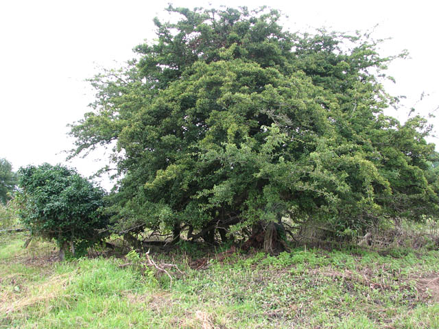
Lady Belt, Norfolk is a picturesque woodland area located in the county of Norfolk, England. Spanning over a vast area, it is renowned for its dense forest and enchanting natural beauty. Lady Belt is situated near the village of Woodton and is a popular destination for nature lovers, hikers, and wildlife enthusiasts.

The woodland of Lady Belt is characterized by its diverse range of trees, including oak, beech, and pine, creating a rich and vibrant ecosystem. It is home to an array of wildlife, including various species of birds, mammals, and insects. Visitors can spot deer, badgers, and foxes, as well as a variety of bird species such as woodpeckers and owls.

The forest offers a tranquil and peaceful environment, providing visitors with an opportunity to connect with nature and escape the hustle and bustle of everyday life. There are several walking trails and paths throughout the woodland, allowing visitors to explore its beauty at their own pace. The trails offer different levels of difficulty, catering to both casual walkers and experienced hikers.

Lady Belt also has a rich historical significance. The woodland has been preserved for centuries and has witnessed various historical events. There are remnants of old structures and ancient trees that add to the charm and mystique of the place.

Overall, Lady Belt, Norfolk is a captivating woodland area that offers a perfect blend of natural beauty, diverse wildlife, and historical significance. It is a must-visit destination for nature enthusiasts and those seeking an escape into the serenity of the forest.

If you have any feedback on the listing, please let us know in the comments section below.

Lady Belt Images

Images are sourced within 2km of 52.575174/1.2043077 or Grid Reference TG1702. Thanks to Geograph Open Source API. All images are credited.

The A11 west . 22 miles to Thetford
Hethel: Church Lane outside All Saints Church
Hethel: Entrance to All Saints Church
East Carleton: Entrance to East Carleton Manor
East Carleton, St. Mary's Church: Snowdrops appearing in a small corner of the churchyard
East Carleton, St. Mary's Church: South eastern aspect
East Carleton, St. Mary's Church: Southern aspect
East Carleton, St. Mary's Church: Southern doorway detail
East Carleton, St. Mary's Church: Major Steward memorial, east wall of the south porch 1
East Carleton, St. Mary's Church: Major Steward memorial, east wall of the south porch 2
East Carleton, St. Mary's Church: The chancel
East Carleton, St. Mary's Church: The nave
East Carleton, St. Mary's Church: c15th font
East Carleton, St. Mary's Church: The organ
East Carleton, St. Mary's Church: Lindley memorial
East Carleton, St. Mary's Church: Small roundel, one of two in an otherwise plain glass window
Show me another place!

Lady Belt is located at Grid Ref: TG1702 (Lat: 52.575174, Lng: 1.2043077)

Administrative County: Norfolk

District: South Norfolk

Police Authority: Norfolk

What 3 Words

///wacky.greyhound.newlywed. Near Hethel, Norfolk

Related Wikis

East Carleton

East Carleton is a village and civil parish in the English county of Norfolk. The village is located 6.3 kilometres (3.9 mi) east of nearby Wymondham and...

Ketteringham

Ketteringham is a village and civil parish in the English county of Norfolk. The parish covers an area of 6.50 km2 (2.51 sq mi) and had a population of...

Forehoe and Henstead Rural District

Forehoe and Henstead Rural Districts were adjacent rural districts in Norfolk, England from 1894 to 1935. They were formed under the Local Government Act...

Hethel Old Thorn

Hethel Old Thorn is a 0.025-hectare (0.062-acre) nature reserve south-west of Norwich in Norfolk. It is managed by the Norfolk Wildlife Trust. This is...

Nearby Amenities

Located within 500m of 52.575174,1.2043077
Power: pole
Lat/Long: 52.5767/1.206127
Power: pole
Lat/Long: 52.577678/1.207348
Power: pole
Lat/Long: 52.5776632/1.2090739
Power: pole
Lat/Long: 52.571527/1.206387
Power: pole
Lat/Long: 52.571986/1.205841
Power: pole
Lat/Long: 52.5726399/1.2049377
Power: pole
Lat/Long: 52.5734453/1.205015
Power: pole
Lat/Long: 52.574639/1.205124
Power: pole
Lat/Long: 52.575501/1.205187
Marker: yes
Pipeline: marker
Substance: gas
Utility: gas
Lat/Long: 52.5717406/1.2002027
Bench
Armrest: both
Backrest: yes
Inscription: yes
Material: wood
Seats: 4
Lat/Long: 52.572635/1.2103187
Give Way
Lat/Long: 52.5717564/1.2002995
Leisure: picnic_table
Lat/Long: 52.5756148/1.203986
Bench
Backrest: yes
Material: wood
Note: Carved from a tree trunk.
Seats: 2
Lat/Long: 52.5775871/1.1989823
Access: private
Barrier: swing_gate
Bicycle: no
Foot: no
Lat/Long: 52.5781584/1.2079892
Bench
Backrest: no
Lat/Long: 52.5760809/1.2034043
Covered: no
Leisure: picnic_table
Lat/Long: 52.5786579/1.2057281
Bench
Backrest: no
Material: wood
Seats: 3
Lat/Long: 52.579314/1.2044862
Artwork Type: sculpture
Material: wood
Note: Several wood carved animals.
Tourism: artwork
Lat/Long: 52.5784444/1.1999103
Access: private
Entrance: main
Lat/Long: 52.5782348/1.2000775
Covered: no
Leisure: picnic_table
Lat/Long: 52.5785504/1.2052104
Bench
Backrest: yes
Material: wood
Seats: 3
Lat/Long: 52.5783548/1.2019408
Ford: yes
Note: Usually just muddy.
Lat/Long: 52.5794947/1.2040269
Colour: red and white
Marker: aerial
Utility: gas
Lat/Long: 52.5753843/1.2093369
Colour: red and white
Marker: aerial
Utility: gas
Lat/Long: 52.5755341/1.2094661
Colour: yellow
Inscription: CP
Marker: post
Utility: gas
Lat/Long: 52.5753848/1.2093424
Colour: yellow
Marker: post
Utility: gas
Lat/Long: 52.5754146/1.2093571
Colour: yellow
Inscription: GAS LTS HP GAS PIPELINE
Marker: post
Utility: gas
Lat/Long: 52.5755334/1.2094604
Give Way
Lat/Long: 52.5727167/1.210347
The data included in this document is from www.openstreetmap.org. The data is made available under ODbL.

Have you been to Lady Belt?

Leave your review of Lady Belt below (or comments, questions and feedback).