Foxup

Settlement in Yorkshire Craven

England

Foxup

Halton Gill from Stainforth Road Later see <a title="https://www.geograph.org.uk/photo/1990974" href="https://www.geograph.org.uk/photo/1990974">Link</a>
Halton Gill from Stainforth Road Credit: Dr. Derrick Sherwin Bailey

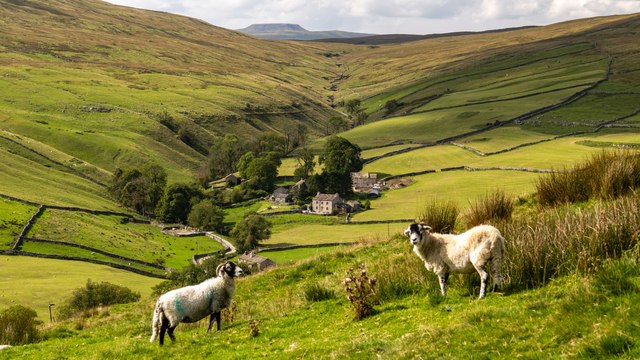
Foxup is a small village located in the Craven district of North Yorkshire, England. Situated in the heart of the Yorkshire Dales National Park, it is surrounded by picturesque landscapes and rolling hills. The village is nestled in the upper reaches of the River Wharfe valley, making it an ideal destination for nature lovers and outdoor enthusiasts.

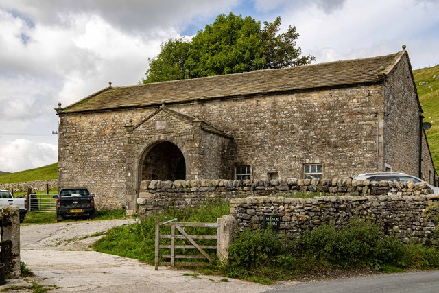
With a population of less than 100 residents, Foxup is known for its tranquility and close-knit community. The village consists of a handful of stone-built houses, some of which date back to the 17th century, giving the area a charming and historic feel. There are no shops or amenities in Foxup itself, but the nearby town of Grassington offers a range of services just a short drive away.

The village's location provides ample opportunities for outdoor activities, including hiking, cycling, and fishing. The surrounding area is crisscrossed with footpaths and bridleways, allowing visitors to explore the stunning natural beauty of the Yorkshire Dales. Nearby attractions include the historic Bolton Abbey, renowned for its stunning ruins and scenic walks along the river.

Foxup offers a peaceful retreat away from the hustle and bustle of city life, allowing visitors to immerse themselves in the idyllic countryside of Yorkshire. Its quiet charm and breathtaking landscapes make it a popular destination for those seeking a rural getaway and a chance to experience the true beauty of the Dales.

If you have any feedback on the listing, please let us know in the comments section below.

Foxup Images

Images are sourced within 2km of 54.185734/-2.199329 or Grid Reference SD8776. Thanks to Geograph Open Source API. All images are credited.

Halton Gill from Stainforth Road Later see <a title="https://www.geograph.org.uk/photo/1990974" href="https://www.geograph.org.uk/photo/1990974">Link</a>
Halton Gill from Stainforth Road
Later see Link
Halton Gill Panorama in 2000 View north to the hamlet with Horse Head Moor above
Halton Gill Panorama in 2000
View north to the hamlet with Horse Head Moor above
Halton Gill Sheep alongside the River Skirfare seen from Halton Gill Bridge.
Halton Gill
Sheep alongside the River Skirfare seen from Halton Gill Bridge.
Halton Gill Farmer at work above Halton Gill
Halton Gill
Farmer at work above Halton Gill
Foxup The farm and houses at Foxup with the valley of Foxup Beck cutting through Foxup Moor in the background.  In the far distance, over the horizon, is the distinctive outline of Ingleborough.
Foxup
The farm and houses at Foxup with the valley of Foxup Beck cutting through Foxup Moor in the background. In the far distance, over the horizon, is the distinctive outline of Ingleborough.
River Skirfare Looking down the valley of the River Skirfare.
River Skirfare
Looking down the valley of the River Skirfare.
Halton Gill Beck Byway crossing one of the tributaries to Halton Gill Beck.
Halton Gill Beck
Byway crossing one of the tributaries to Halton Gill Beck.
Halton Gill
Halton Gill
Manor Farm Impressive barn in Halton Gill.
Manor Farm
Impressive barn in Halton Gill.
Hesleden Burge Sheep sitting in amongst the limestone.
Hesleden Burge
Sheep sitting in amongst the limestone.
Halton Gill Gateway on the byway up from Halton Gill to Horse Head.
Halton Gill
Gateway on the byway up from Halton Gill to Horse Head.
Halton Gill
Halton Gill
Steep hill above Halton Gill
Littondale from road south of Hesleden Bergh
Halton Gill Bridge
Halton Gill Bridge
Halton Gill from the bridge
Fields in valley of River Skirfare east of Halton Gill
Three ash trees by Newshot Gill
Show me another place!

Foxup is located at Grid Ref: SD8776 (Lat: 54.185734, Lng: -2.199329)

Division: West Riding

Administrative County: North Yorkshire

District: Craven

Police Authority: North Yorkshire

What 3 Words

///duos.stable.lobbed. Near Settle, North Yorkshire

Nearby Locations

Foxup

Related Wikis

Foxup

Foxup is a hamlet in the Yorkshire Dales in the Craven district of North Yorkshire, England. The hamlet is near Halton Gill and Litton and is 13 miles...

Halton Gill

Halton Gill is a hamlet and civil parish in Littondale in the Yorkshire Dales in North Yorkshire, England. It is situated 2 miles (3.2 km) up Littondale...

Ewecross

The historical area of Ewecross or Ewcross is a district in the West Riding of Yorkshire, England. It included the parishes of Bentham, Clapham, Horton...

Plover Hill

Plover Hill is an area of moorland lying to the north of Pen-y-ghent in the Yorkshire Dales and connected to it by an unbroken area of high ground. Whilst...

Nearby Amenities

Located within 500m of 54.185734,-2.199329
Foxup
Is In: UK, England, Yorkshire, North Yorkshire, Yorkshire Dales, Littondale
Is In County: North Yorkshire
Is In Historic County: Yorkshire
Is In Municipality: Craven
Place: hamlet
Postal Code: BD23
Wikidata: Q5477275
Wikipedia: en:Foxup
Lat/Long: 54.1858286/-2.2015819
Low Bergh
Is In: UK, England, Yorkshire, North Yorkshire, Yorkshire Dales, Littondale
Is In Historic County: Yorkshire
Place: locality
Lat/Long: 54.1820838/-2.2003435
Gill Side Lathes
Is In: UK, England, Yorkshire, North Yorkshire, Yorkshire Dales, Littondale
Is In Historic County: Yorkshire
Place: locality
Lat/Long: 54.183862/-2.2055661
Historic: mine_shaft
Note: very tentative, needs confirming
Source: Bing
Lat/Long: 54.1826498/-2.1942511
Helk House
Archaeological Site: barn
Historic: archaeological_site
Source: OS sheet 97,1851
Lat/Long: 54.1884129/-2.2043198
Power: pole
Lat/Long: 54.1858537/-2.1922171
Power: pole
Lat/Long: 54.1860841/-2.1933364
Power: pole
Lat/Long: 54.1862051/-2.1938674
Power: pole
Lat/Long: 54.1865149/-2.1954055
Power: pole
Lat/Long: 54.1867234/-2.199724
Power: pole
Lat/Long: 54.1868571/-2.1970013
Power: pole
Lat/Long: 54.1871574/-2.1984653
Archaeological Site: lime_kiln
Historic: archaeological_site
Mineral: limestone
Output: lime
Source: OS 1851 Yorkshire sheet 97
Lat/Long: 54.1869574/-2.2052808
Abandoned Man Made: kiln
Building: ruins
Historic: lime_kiln
Mineral: limestone
Product: quicklime
Source: OS 1851 sheet 97;DigitalGlobe-Standard
Lat/Long: 54.1826466/-2.1961976
Natural: sinkhole
Source: DigitalGlobe-Standard
Lat/Long: 54.1819691/-2.1979333
Natural: sinkhole
Source: DigitalGlobe-Standard
Lat/Long: 54.1819565/-2.1971179
Natural: sinkhole
Source: DigitalGlobe-Standard
Lat/Long: 54.1813287/-2.1990598
Natural: sinkhole
Source: DigitalGlobe-Standard
Lat/Long: 54.1816178/-2.1988238
Natural: sinkhole
Source: DigitalGlobe-Standard
Lat/Long: 54.1818938/-2.1993173
Natural: sinkhole
Source: DigitalGlobe-Standard
Lat/Long: 54.1854349/-2.1963291
Natural: sinkhole
Source: DigitalGlobe-Standard
Lat/Long: 54.1854098/-2.1952723
The data included in this document is from www.openstreetmap.org. The data is made available under ODbL.

Have you been to Foxup?

Leave your review of Foxup below (or comments, questions and feedback).