Lower Fir Covert

Wood, Forest in Norfolk North Norfolk

England

Lower Fir Covert

Platform 2 at Holt Station This train is standing at Platform 2 at Holt Station, waiting to return to Sheringham on the North Norfolk Railway. The platforms at Holt are staggered and this image is taken from the inner end of Platform 1.
Platform 2 at Holt Station Credit: Glen Denny

Lower Fir Covert is a wood located in Norfolk, England. It is a part of the larger Norfolk forests that cover vast areas of the county. The covert is situated in the eastern region of Norfolk, near the villages of Fir Covert and Fir Covert Cross.

Covering an area of approximately 150 acres, Lower Fir Covert is a dense forest with a diverse range of native trees and vegetation. It is primarily composed of deciduous trees such as oak, beech, and birch, along with some coniferous species like pine and spruce. The forest floor is rich in flora, with a variety of wildflowers, ferns, and mosses.

The woodland provides a habitat for a wide range of wildlife. It is home to several bird species, including woodpeckers, owls, and various songbirds. Mammals such as deer, foxes, and badgers can also be found within the covert. Additionally, the forest is inhabited by numerous insects, reptiles, and amphibians, contributing to its ecological significance.

Lower Fir Covert offers a tranquil and picturesque environment for outdoor enthusiasts. It has a network of well-maintained trails, providing opportunities for walking, hiking, and wildlife observation. The forest is a popular destination for nature lovers and photographers, especially during the spring when the trees bloom and the forest is filled with vibrant colors.

Overall, Lower Fir Covert is a valuable natural resource in Norfolk. It serves as an important habitat for wildlife, while also providing recreational opportunities for visitors to enjoy the beauty and tranquility of this woodland area.

If you have any feedback on the listing, please let us know in the comments section below.

Lower Fir Covert Images

Images are sourced within 2km of 52.905056/1.1292129 or Grid Reference TG1038. Thanks to Geograph Open Source API. All images are credited.

Platform 2 at Holt Station This train is standing at Platform 2 at Holt Station, waiting to return to Sheringham on the North Norfolk Railway. The platforms at Holt are staggered and this image is taken from the inner end of Platform 1.
Platform 2 at Holt Station
This train is standing at Platform 2 at Holt Station, waiting to return to Sheringham on the North Norfolk Railway. The platforms at Holt are staggered and this image is taken from the inner end of Platform 1.
Holt Minor Station Adjacent to the North Norfolk Railway station at Holt is a passenger carrying miniature railway. This building serves as station for the miniature railway.
Holt Minor Station
Adjacent to the North Norfolk Railway station at Holt is a passenger carrying miniature railway. This building serves as station for the miniature railway.
North Norfolk Railway at Holt This is the view from Platform 1 at Holt Station, towards Weybourne and Sheringham. Although there are two lines in the station area, the line becomes single track at the far signal, with the second line beyond this point being used as a siding. On the left can be seen the signal box, along with the newly constructed water crane, at the end of what will become an extended Platform 1. Behind the signal box is another siding.
North Norfolk Railway at Holt
This is the view from Platform 1 at Holt Station, towards Weybourne and Sheringham. Although there are two lines in the station area, the line becomes single track at the far signal, with the second line beyond this point being used as a siding. On the left can be seen the signal box, along with the newly constructed water crane, at the end of what will become an extended Platform 1. Behind the signal box is another siding.
Platform 2 at Holt Station The two platforms at Holt Station are staggered and this is the view from part way along Platform 1 of Platform 2. The two tracks shown are connected at the far end of Platform 2, which allows locomotives to run round. To the right can be seen part of the station car park, with additional car parking facilities being found in the field behind Platform 2.
Platform 2 at Holt Station
The two platforms at Holt Station are staggered and this is the view from part way along Platform 1 of Platform 2. The two tracks shown are connected at the far end of Platform 2, which allows locomotives to run round. To the right can be seen part of the station car park, with additional car parking facilities being found in the field behind Platform 2.
View across the north-eastern part of Holt Lowes Holt Lowes comprises 25 acres of mixed wood and heathland adjoining Holt Country Park in the east. It is currently in the process of being converted into heathland. The first stage of the clearance work, involving removal of birch trees, gorse and leaf litter, was completed in March. Work will start again in autumn.
View across the north-eastern part of Holt Lowes
Holt Lowes comprises 25 acres of mixed wood and heathland adjoining Holt Country Park in the east. It is currently in the process of being converted into heathland. The first stage of the clearance work, involving removal of birch trees, gorse and leaf litter, was completed in March. Work will start again in autumn.
Silver Birch bordering the flood plain near the River Glaven
Seat beside a track through Holt Lowes Holt Lowes comprises 25 acres of mixed wood and heathland adjoining Holt Country Park in the east. It is currently in the process of being converted into heathland. The first stage of the clearance work, involving removal of birch trees, gorse and leaf litter, was completed in March. Work will start again in autumn.
Seat beside a track through Holt Lowes
Holt Lowes comprises 25 acres of mixed wood and heathland adjoining Holt Country Park in the east. It is currently in the process of being converted into heathland. The first stage of the clearance work, involving removal of birch trees, gorse and leaf litter, was completed in March. Work will start again in autumn.
Holt Lowes Holt Lowes comprises 25 acres of mixed wood and heathland adjoining Holt Country Park in the east. It is currently in the process of being converted into heathland. The first stage of the clearance work, involving removal of birch trees, gorse and leaf litter, was completed in March. Work will start again in autumn.
Holt Lowes
Holt Lowes comprises 25 acres of mixed wood and heathland adjoining Holt Country Park in the east. It is currently in the process of being converted into heathland. The first stage of the clearance work, involving removal of birch trees, gorse and leaf litter, was completed in March. Work will start again in autumn.
Bracken on Holt Lowes Holt Lowes comprises 25 acres of mixed wood and heathland adjoining Holt Country Park in the east. It is currently in the process of being converted into heathland. The first stage of the clearance work, involving removal of birch trees, gorse and leaf litter, was completed in March. Work will start again in autumn.
Bracken on Holt Lowes
Holt Lowes comprises 25 acres of mixed wood and heathland adjoining Holt Country Park in the east. It is currently in the process of being converted into heathland. The first stage of the clearance work, involving removal of birch trees, gorse and leaf litter, was completed in March. Work will start again in autumn.
View across Holt Lowes Holt Lowes comprises 25 acres of mixed wood and heathland adjoining Holt Country Park in the east. It is currently in the process of being converted into heathland. The first stage of the clearance work, involving removal of birch trees, gorse and leaf litter, was completed in March. Work will start again in autumn.
View across Holt Lowes
Holt Lowes comprises 25 acres of mixed wood and heathland adjoining Holt Country Park in the east. It is currently in the process of being converted into heathland. The first stage of the clearance work, involving removal of birch trees, gorse and leaf litter, was completed in March. Work will start again in autumn.
At the bottom of Holt Lowes Holt Lowes comprises 25 acres of mixed wood and heathland adjoining Holt Country Park in the east. It is currently in the process of being converted into heathland. The first stage of the clearance work, involving removal of birch trees, gorse and leaf litter, was completed in March. Work will start again in autumn.
At the bottom of Holt Lowes
Holt Lowes comprises 25 acres of mixed wood and heathland adjoining Holt Country Park in the east. It is currently in the process of being converted into heathland. The first stage of the clearance work, involving removal of birch trees, gorse and leaf litter, was completed in March. Work will start again in autumn.
Orchids beside the path on Holt Lowes Holt Lowes comprises 25 acres of mixed wood and heathland adjoining Holt Country Park in the east. It is currently in the process of being converted into heathland. The first stage of the clearance work, involving removal of birch trees, gorse and leaf litter, was completed in March. Work will start again in autumn.
Orchids beside the path on Holt Lowes
Holt Lowes comprises 25 acres of mixed wood and heathland adjoining Holt Country Park in the east. It is currently in the process of being converted into heathland. The first stage of the clearance work, involving removal of birch trees, gorse and leaf litter, was completed in March. Work will start again in autumn.
On the edge of Holt Lowes Holt Lowes comprises 25 acres of mixed wood and heathland adjoining Holt Country Park in the east. It is currently in the process of being converted into heathland. The first stage of the clearance work, involving removal of birch trees, gorse and leaf litter, was completed in March. Work will start again in autumn.
On the edge of Holt Lowes
Holt Lowes comprises 25 acres of mixed wood and heathland adjoining Holt Country Park in the east. It is currently in the process of being converted into heathland. The first stage of the clearance work, involving removal of birch trees, gorse and leaf litter, was completed in March. Work will start again in autumn.
Orchid meadow on Holt Lowes Holt Lowes comprises 25 acres of mixed wood and heathland adjoining Holt Country Park in the east. It is currently in the process of being converted into heathland. The first stage of the clearance work, involving removal of birch trees, gorse and leaf litter, was completed in March. Work will start again in autumn.
Orchid meadow on Holt Lowes
Holt Lowes comprises 25 acres of mixed wood and heathland adjoining Holt Country Park in the east. It is currently in the process of being converted into heathland. The first stage of the clearance work, involving removal of birch trees, gorse and leaf litter, was completed in March. Work will start again in autumn.
Orchids and reeds on Holt Lowes Holt Lowes comprises 25 acres of mixed wood and heathland adjoining Holt Country Park in the east. It is currently in the process of being converted into heathland. The first stage of the clearance work, involving removal of birch trees, gorse and leaf litter, was completed in March. Work will start again in autumn.
Orchids and reeds on Holt Lowes
Holt Lowes comprises 25 acres of mixed wood and heathland adjoining Holt Country Park in the east. It is currently in the process of being converted into heathland. The first stage of the clearance work, involving removal of birch trees, gorse and leaf litter, was completed in March. Work will start again in autumn.
Hempstead Watermill This mill was once a proud building, the machinery is still intact but the externals are overgrown. See <span class="nowrap"><a title="http://www.norfolkmills.co.uk/Watermills/hempstead.html" rel="nofollow ugc noopener" href="http://www.norfolkmills.co.uk/Watermills/hempstead.html">Link</a><img style="margin-left:2px;" alt="External link" title="External link - shift click to open in new window" src="https://s1.geograph.org.uk/img/external.png" width="10" height="10"/></span>
Hempstead Watermill
This mill was once a proud building, the machinery is still intact but the externals are overgrown. See LinkExternal link
M&GN Brake Van Midland and Great Northern Joint Railway brake van number No. 12. Built for the Lynn and Fakenham in 1881 at Birmingham carriage works. It passed onto the Eastern and Midlands railway (who built this line). The E&MR was absorbed by the new M&GN in 1893. 
The vehicle was once part of the Melton constable break down train.
Before <a href="https://www.geograph.org.uk/photo/1185762">TG1141 : M&GN vehicles in the carriage sheds</a> and mid term <a href="https://www.geograph.org.uk/photo/1481156">TG1141 : M&GN Brake van number 12</a>
M&GN Brake Van
Midland and Great Northern Joint Railway brake van number No. 12. Built for the Lynn and Fakenham in 1881 at Birmingham carriage works. It passed onto the Eastern and Midlands railway (who built this line). The E&MR was absorbed by the new M&GN in 1893. The vehicle was once part of the Melton constable break down train. Before TG1141 : M&GN vehicles in the carriage sheds and mid term TG1141 : M&GN Brake van number 12
L99 at Holt GWR pannier 7715 was the last steam engine used on the underground. It has been restored as L99 in London Transport maroon. The engine is taking water from a recently installed Eastern and Midlands railway water column.
L99 at Holt
GWR pannier 7715 was the last steam engine used on the underground. It has been restored as L99 in London Transport maroon. The engine is taking water from a recently installed Eastern and Midlands railway water column.
Show me another place!

Lower Fir Covert is located at Grid Ref: TG1038 (Lat: 52.905056, Lng: 1.1292129)

Administrative County: Norfolk

District: North Norfolk

Police Authority: Norfolk

What 3 Words

///spokes.register.comically. Near Sheringham, Norfolk

Related Wikis

High Kelling

High Kelling is a village and civil parish in the north of the English county of Norfolk. The village is located on the A148 road which links Cromer to...
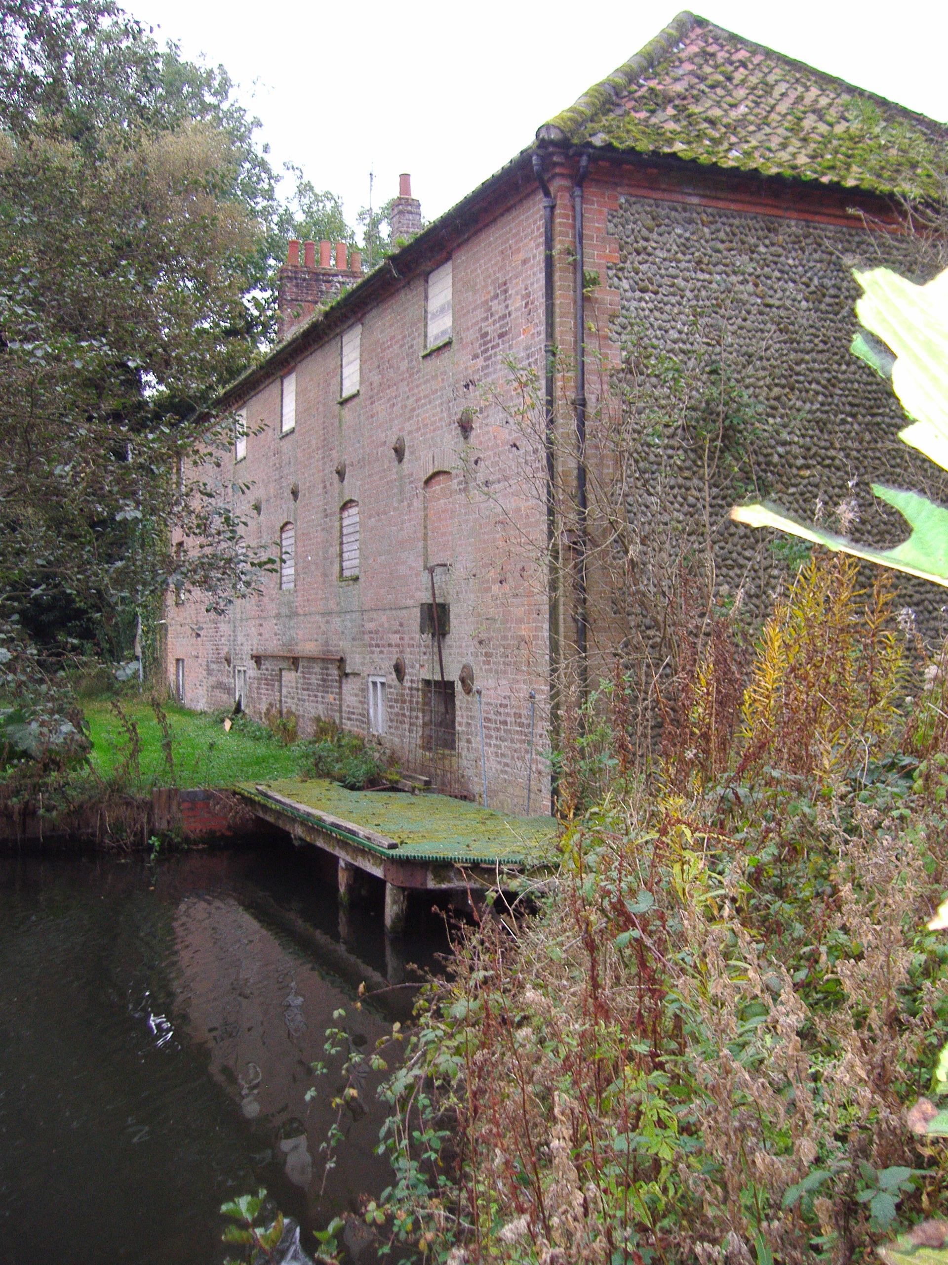
Hempstead Watermill

Hempstead Watermill is a disused watermill 1.7 miles south east of the town of Holt in the English county of Norfolk. The mill stands on the River Glaven...

Home Place, Kelling

Home Place, also called Voewood, is an Arts and Crafts style house in High Kelling, near Holt, Norfolk, England, designed (1903–5) by Edward Schroeder...

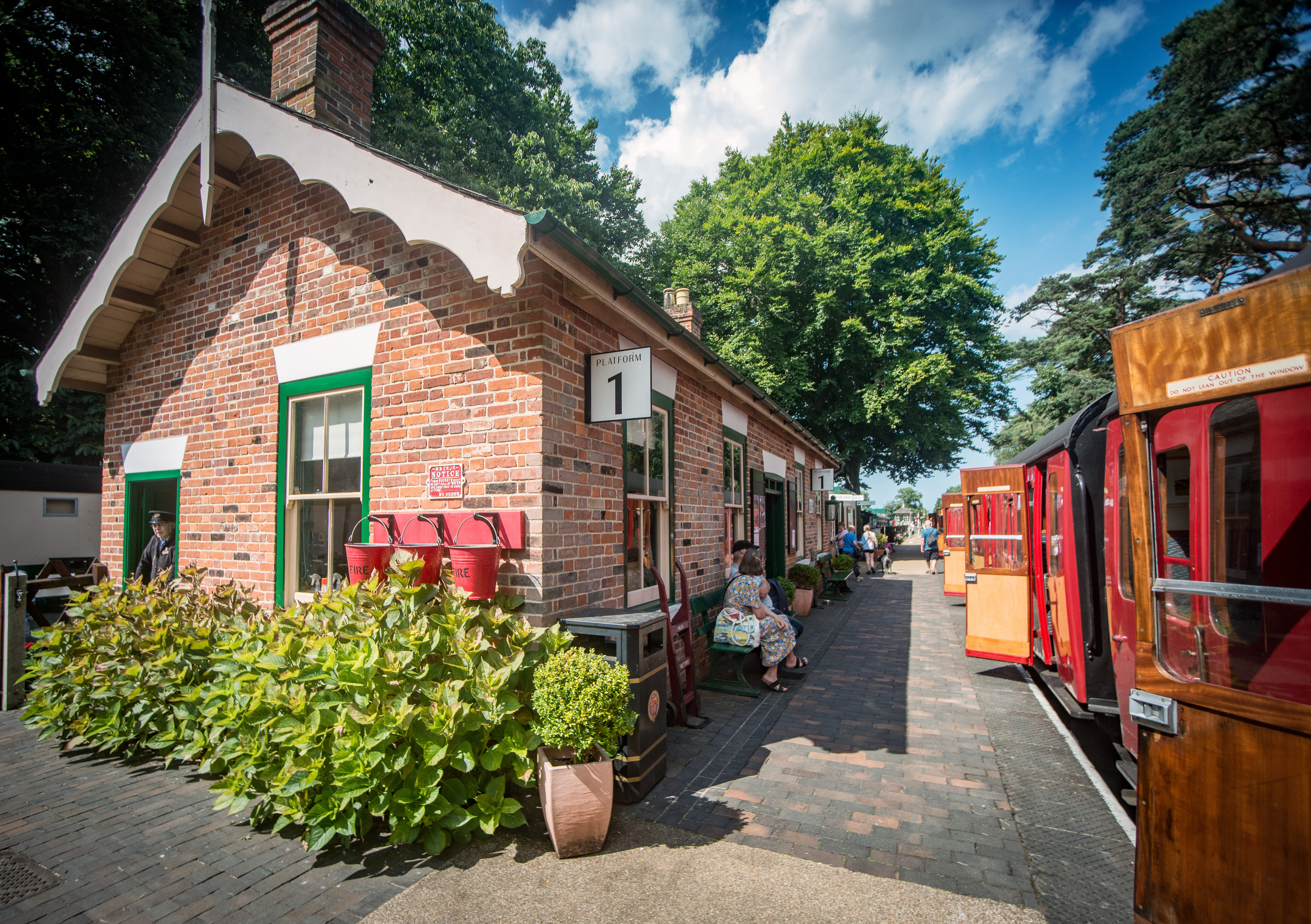
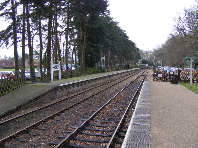
Holt railway station (North Norfolk Railway)

Holt railway station, opened in 1987, is the current terminus of the North Norfolk Railway and is a new-build station half a mile south of the proposed...

Hempstead, near Holt, Norfolk

There is also a village called Hempstead near Stalham, also in North Norfolk.Hempstead is a village and civil parish in the north of the English county...

Farfield

Farfield is one of the seven boarding houses at Gresham's, an English public school at Holt, Norfolk. Farfield is currently home to approximately fifty...
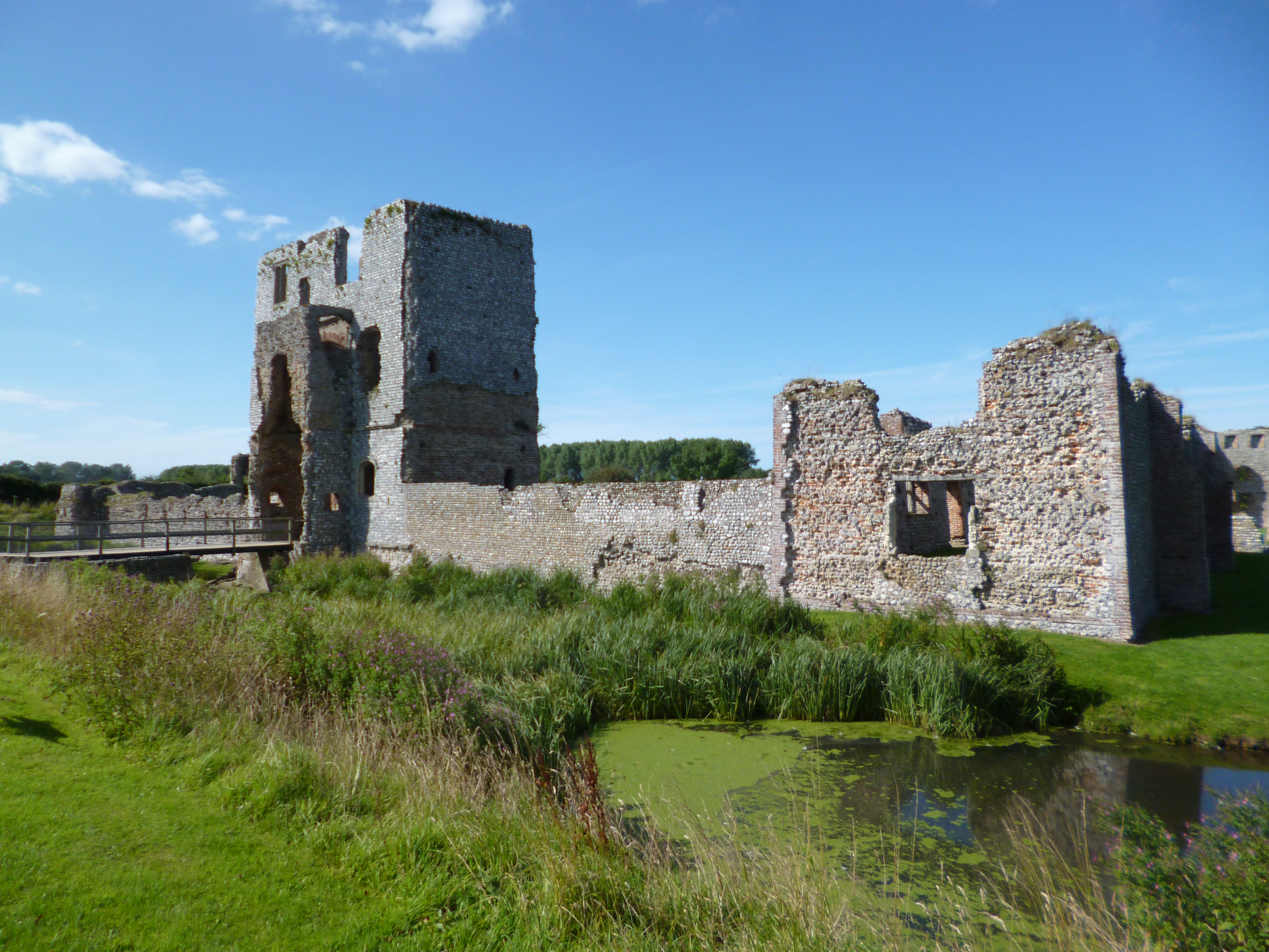
Baconsthorpe Castle

Baconsthorpe Castle, historically known as Baconsthorpe Hall, is a ruined, fortified manor house near the village of Baconsthorpe, Norfolk, England. It...

Gresham's School

Gresham's School is a public school (English fee-charging boarding and day school) in Holt, Norfolk, England, one of the top thirty International Baccalaureate...

Nearby Amenities

Located within 500m of 52.905056,1.1292129
Dole Close Plantation
Place: locality
Lat/Long: 52.9062748/1.1283725
Lower Fir Covert
Place: locality
Lat/Long: 52.9054459/1.1297752
Upper Fir Covert
Place: locality
Lat/Long: 52.9043994/1.1310733
Selbrigg Lodge
Place: isolated_dwelling
Lat/Long: 52.906109/1.1346955
The data included in this document is from www.openstreetmap.org. The data is made available under ODbL.

Have you been to Lower Fir Covert?

Leave your review of Lower Fir Covert below (or comments, questions and feedback).