Jims Wood

Wood, Forest in Suffolk Mid Suffolk

England

Jims Wood

Church of St Andrew, Wickham Skeith <span class="nowrap"><a title="https://historicengland.org.uk/listing/the-list/list-entry/1352521?section=official-list-entry" rel="nofollow ugc noopener" href="https://historicengland.org.uk/listing/the-list/list-entry/1352521?section=official-list-entry">Link</a><img style="margin-left:2px;" alt="External link" title="External link - shift click to open in new window" src="https://s1.geograph.org.uk/img/external.png" width="10" height="10"/></span>
Church of St Andrew, Wickham Skeith Credit: Sandy Gerrard

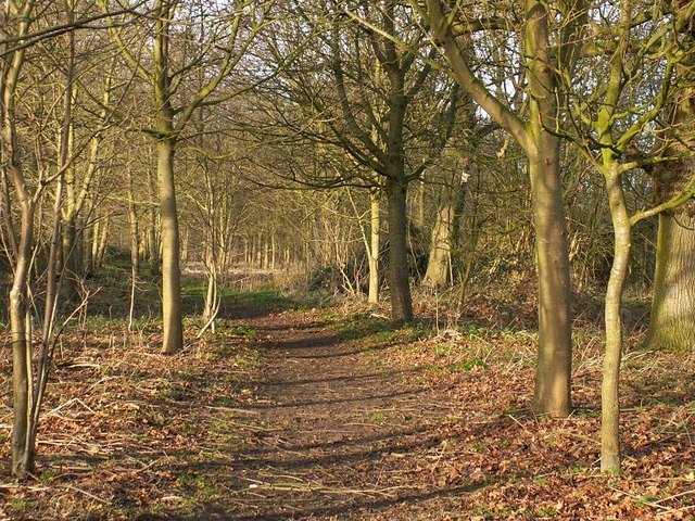
Jim's Wood is a picturesque forest located in Suffolk, England. Spanning over a vast area, the wood is known for its serene beauty and abundant wildlife. The forest is situated near the village of Suffolk, and its accessibility makes it a popular destination for nature enthusiasts and locals alike.

The woodland is primarily made up of deciduous trees, including oak, beech, and birch. These trees provide a stunning display of colors during the autumn season, attracting visitors who come to witness the vibrant foliage. The forest floor is also adorned with a variety of wildflowers, adding to the wood's charm.

Jim's Wood is home to a diverse range of wildlife, making it a haven for animal lovers and birdwatchers. Visitors have the opportunity to spot various species, including deer, foxes, badgers, and squirrels. The forest is also frequented by bird species such as woodpeckers, owls, and songbirds, offering an ideal location for birdwatching enthusiasts.

The wood provides ample opportunities for outdoor activities, with several well-maintained walking trails and picnic areas. These trails lead visitors through the heart of the forest, allowing them to soak in the natural beauty and tranquility of the surroundings. There are also designated areas for camping and fishing, providing an immersive experience for those looking to spend more time in the wood.

Overall, Jim's Wood in Suffolk is a captivating forest that offers a peaceful retreat from the hustle and bustle of everyday life. With its stunning scenery, abundant wildlife, and recreational facilities, it is a perfect destination for nature lovers and those seeking a respite in the great outdoors.

If you have any feedback on the listing, please let us know in the comments section below.

Jims Wood Images

Images are sourced within 2km of 52.292529/1.0576414 or Grid Reference TM0870. Thanks to Geograph Open Source API. All images are credited.

Church of St Andrew, Wickham Skeith <span class="nowrap"><a title="https://historicengland.org.uk/listing/the-list/list-entry/1352521?section=official-list-entry" rel="nofollow ugc noopener" href="https://historicengland.org.uk/listing/the-list/list-entry/1352521?section=official-list-entry">Link</a><img style="margin-left:2px;" alt="External link" title="External link - shift click to open in new window" src="https://s1.geograph.org.uk/img/external.png" width="10" height="10"/></span>
Church of St Andrew, Wickham Skeith
Rood Loft Stair at Church of St Andrew, Wickham Skeith <span class="nowrap"><a title="https://historicengland.org.uk/listing/the-list/list-entry/1352521?section=official-list-entry" rel="nofollow ugc noopener" href="https://historicengland.org.uk/listing/the-list/list-entry/1352521?section=official-list-entry">Link</a><img style="margin-left:2px;" alt="External link" title="External link - shift click to open in new window" src="https://s1.geograph.org.uk/img/external.png" width="10" height="10"/></span>
Rood Loft Stair at Church of St Andrew, Wickham Skeith
Font at Church of St Andrew, Wickham Skeith <span class="nowrap"><a title="https://historicengland.org.uk/listing/the-list/list-entry/1352521?section=official-list-entry" rel="nofollow ugc noopener" href="https://historicengland.org.uk/listing/the-list/list-entry/1352521?section=official-list-entry">Link</a><img style="margin-left:2px;" alt="External link" title="External link - shift click to open in new window" src="https://s1.geograph.org.uk/img/external.png" width="10" height="10"/></span>
Font at Church of St Andrew, Wickham Skeith
Doorway at Church of St Andrew, Wickham Skeith <span class="nowrap"><a title="https://historicengland.org.uk/listing/the-list/list-entry/1352521?section=official-list-entry" rel="nofollow ugc noopener" href="https://historicengland.org.uk/listing/the-list/list-entry/1352521?section=official-list-entry">Link</a><img style="margin-left:2px;" alt="External link" title="External link - shift click to open in new window" src="https://s1.geograph.org.uk/img/external.png" width="10" height="10"/></span>
Doorway at Church of St Andrew, Wickham Skeith
Footpath from Thornham Magna to Wickham Skeith
Blue Skies And Green Grass Country view photo taken east of Wickham Skeith Suffolk.
Blue Skies And Green Grass
Country view photo taken east of Wickham Skeith Suffolk.
Farm track through pastures at Wickham Skeith The track serves as a public footpath.
Farm track through pastures at Wickham Skeith
The track serves as a public footpath.
Footpath to Wickham Skeith This public footpath follows a track and links Colsey Wood with Wickham Skeith. The trees seen in the background surround St Andrew's church, a dry ford can be seen in the foreground.
Footpath to Wickham Skeith
This public footpath follows a track and links Colsey Wood with Wickham Skeith. The trees seen in the background surround St Andrew's church, a dry ford can be seen in the foreground.
Wickham Skeith church
Railway Bridge This brick railway bridge carries the Norwich to London main line and it blends well into the surrounding wooded countryside between Gislinham and Thornham Magna.
Railway Bridge
This brick railway bridge carries the Norwich to London main line and it blends well into the surrounding wooded countryside between Gislinham and Thornham Magna.
St Mary's Church, Gislingham St Mary's Church Gislingham showing the distinctive red brick tower added in 1639. This replaced the original tower which collapsed in 1598.
St Mary's Church, Gislingham
St Mary's Church Gislingham showing the distinctive red brick tower added in 1639. This replaced the original tower which collapsed in 1598.
Path on the Thornham Estate Thornham Estate is a beautiful place to walk and is open to the public each day. There are 12 miles of footpaths through ancient parkland, woodland, farmland and water meadows.
Path on the Thornham Estate
Thornham Estate is a beautiful place to walk and is open to the public each day. There are 12 miles of footpaths through ancient parkland, woodland, farmland and water meadows.
Bridleway at Finningham This bridleway links the Finningham to Gislingham road with Jenny's Farm.
Bridleway at Finningham
This bridleway links the Finningham to Gislingham road with Jenny's Farm.
Winding road to Gislingham The Finningham to Gislingham road, north of Finningham.
Winding road to Gislingham
The Finningham to Gislingham road, north of Finningham.
Redhouse Farm, Gislingham Bales of hay stacked high outside the farm buildings, viewed from the minor road between Finningham and Gislingham.
Redhouse Farm, Gislingham
Bales of hay stacked high outside the farm buildings, viewed from the minor road between Finningham and Gislingham.
St Mary's Church, Gislingham The distinctive red tower, viewed in evening light.
St Mary's Church, Gislingham
The distinctive red tower, viewed in evening light.
Footpath through copse This unnamed copse lies south of Eastlands Farm, Finningham.  The path runs through the centre.
Footpath through copse
This unnamed copse lies south of Eastlands Farm, Finningham. The path runs through the centre.
Footpath near Eastlands Farm This path commences from the track to Eastlands Farm, heading east through this unnamed copse.
Footpath near Eastlands Farm
This path commences from the track to Eastlands Farm, heading east through this unnamed copse.
Show me another place!

Jims Wood is located at Grid Ref: TM0870 (Lat: 52.292529, Lng: 1.0576414)

Administrative County: Suffolk

District: Mid Suffolk

Police Authority: Suffolk

What 3 Words

///burden.effort.leave. Near Bacton, Suffolk

Nearby Locations

Dormer's Wood Jims Wood

Related Wikis

Gislingham

Gislingham is a village and civil parish in the Mid Suffolk district of Suffolk in eastern England. == History == Gislingham is situated around the area...

Hartismere Hundred

Hartismere was a hundred of Suffolk, that later gave its name to a poor law union, a rural sanitary district, and the Hartismere Rural District. Listed...

Wickham Skeith

Wickham Skeith is a village and civil parish in Suffolk, England, about 5 miles to the west of Eye and about 3 miles east of Finningham. == History... ==

Thornham Magna

Thornham Magna is the larger sister village of Thornham Parva on the former estate of Thornham Hall, the Henniker family seat, in Suffolk. It is about...

Have you been to Jims Wood?

Leave your review of Jims Wood below (or comments, questions and feedback).