Magdalen Wood

Wood, Forest in Essex Colchester

England

Magdalen Wood

Telephone Box, Highwoods
Telephone Box, Highwoods Credit: PAUL FARMER

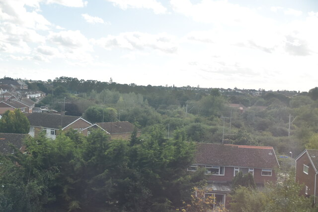
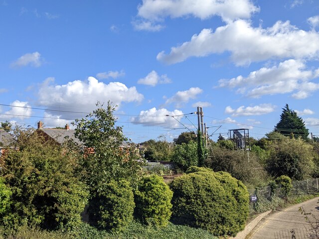
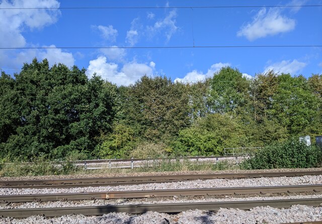
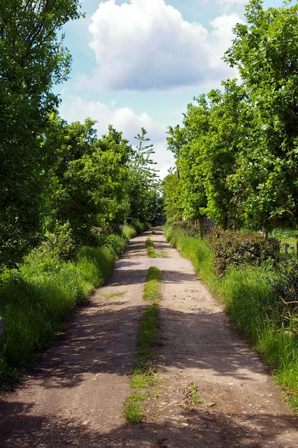
Magdalen Wood, located in Essex, England, is a picturesque and enchanting forest that covers an area of approximately 200 acres. The wood is named after the nearby village of Magdalen Laver and is often referred to simply as Magdalen Wood. This ancient woodland is a designated Site of Special Scientific Interest (SSSI) due to its ecological importance and its rich biodiversity.

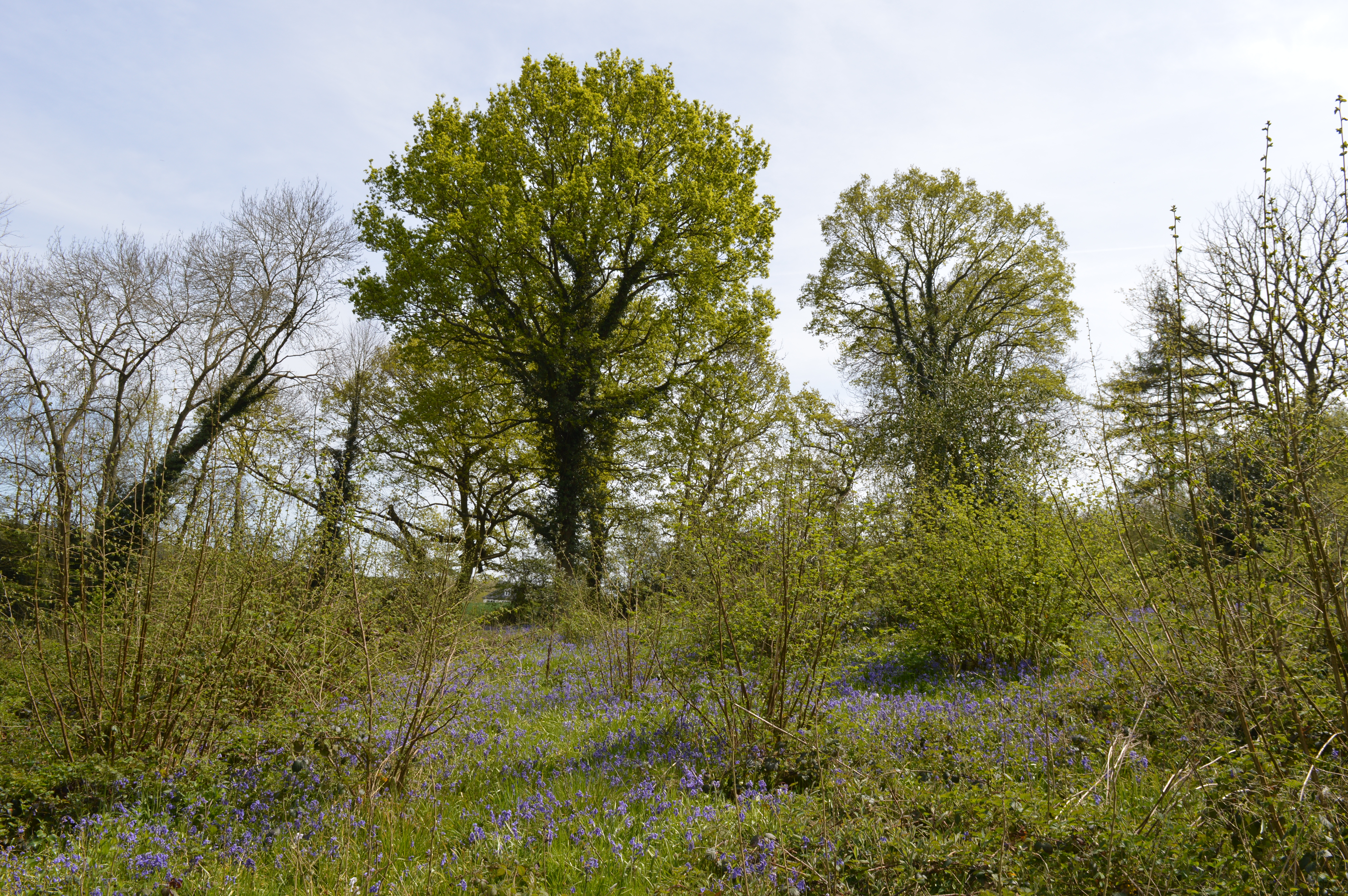
The wood is primarily composed of broadleaf trees, with a diverse range of species including oak, ash, beech, and birch. These majestic trees create a dense canopy that shelters a vibrant undergrowth of ferns, bluebells, and wildflowers. The forest floor is also home to a variety of fungi, adding to the woodland's ecological significance.

Magdalen Wood is renowned for its wildlife and is a haven for nature enthusiasts. The forest provides a suitable habitat for a range of animal species, such as deer, badgers, foxes, and numerous bird species including woodpeckers, tits, and owls. Visitors can often spot these creatures while walking along the well-maintained trails that wind through the wood.

The wood is managed by the Essex Wildlife Trust, which ensures the preservation and conservation of this unique natural environment. They offer guided walks and educational programs for visitors of all ages, allowing them to explore and learn about the woodland's ecosystem.

Magdalen Wood is not only a place of natural beauty but also a place of tranquility and peace, providing a much-needed escape from the hustle and bustle of everyday life. Whether it be for a leisurely stroll, a wildlife-spotting adventure, or an educational outing, Magdalen Wood offers a truly enchanting experience for all who visit.

If you have any feedback on the listing, please let us know in the comments section below.

Magdalen Wood Images

Images are sourced within 2km of 51.905985/0.92845864 or Grid Reference TM0127. Thanks to Geograph Open Source API. All images are credited.

Telephone Box, Highwoods
Farmland near Colchester
Outskirts of Colchester
Joining the main line from the Colchester Town chord
Train line entering Colchester
Joining train tracks entering Colchester
The Olde Siege House The Olde Siege House (East Bay Colchester). This 15th Century timber framed terrace of three houses (now one property) played a significant role in the siege of Colchester, which took place during the second phase of the English Civil War in the summer of 1648. The Parliamentarian town was taken by the Royalists and was promptly besieged for eleven weeks by Cromwell’s New Model Army. The civil war was finally brought to an end by the signing of a surrender document in the prophetically named “King’s Head Inn”. The red rings on the beams of the building are purported to surround bullet holes from the siege. However my father maintained to the end that he saw red rings being added to the building during his childhood in the early 1930’s..... around holes created with a brace and bit!
The Olde Siege House
The Olde Siege House (East Bay Colchester). This 15th Century timber framed terrace of three houses (now one property) played a significant role in the siege of Colchester, which took place during the second phase of the English Civil War in the summer of 1648. The Parliamentarian town was taken by the Royalists and was promptly besieged for eleven weeks by Cromwell’s New Model Army. The civil war was finally brought to an end by the signing of a surrender document in the prophetically named “King’s Head Inn”. The red rings on the beams of the building are purported to surround bullet holes from the siege. However my father maintained to the end that he saw red rings being added to the building during his childhood in the early 1930’s..... around holes created with a brace and bit!
Sir Charles Lucas Arts College Comprehensive School named after the leader of the Royalist Army during the siege of Colchester in the English Civil War.
Sir Charles Lucas Arts College
Comprehensive School named after the leader of the Royalist Army during the siege of Colchester in the English Civil War.
Wycliffe Baptist Church In Parsons Heath
Wycliffe Baptist Church
In Parsons Heath
The Rovers Tye Public House and Restaurant on Ipswich Road.  The original building is 200 years old and has previously been a farmhouse and a butchers.
The Rovers Tye
Public House and Restaurant on Ipswich Road. The original building is 200 years old and has previously been a farmhouse and a butchers.
The Gilberd School Comprehensive School named after William Gilberd, the pioneer of the study of magnetism in England. He lived in Trinity Street, Colchester.
The Gilberd School
Comprehensive School named after William Gilberd, the pioneer of the study of magnetism in England. He lived in Trinity Street, Colchester.
Unofficial Path This path leads out of High Woods Country Park north of Colchester. However it is of little use to the average walker as you are confronted with the back garden gates of Friars Close (behind the photographer)  and no way to reach a public road or right of way.
Unofficial Path
This path leads out of High Woods Country Park north of Colchester. However it is of little use to the average walker as you are confronted with the back garden gates of Friars Close (behind the photographer) and no way to reach a public road or right of way.
Further Meadow This meadow in High Woods Country Park has never been cultivated due to the soggy nature of the soil. It is now periodically grazed to maintain the habitat for wildlife.
Further Meadow
This meadow in High Woods Country Park has never been cultivated due to the soggy nature of the soil. It is now periodically grazed to maintain the habitat for wildlife.
Highwoods Lake This lake is used to control the water level in the meadows down stream holding excess water thus preventing flooding. This type of flood control is known as a balancing Lake
Highwoods Lake
This lake is used to control the water level in the meadows down stream holding excess water thus preventing flooding. This type of flood control is known as a balancing Lake
Brunel Way This is Brunel Way part of a large business park to the north of Colchester. The mainly service industries based here have to some degree helped alleviate the unemployment caused by the closure of Colchester’s traditional engineering employers such as the lathe company.
Brunel Way
This is Brunel Way part of a large business park to the north of Colchester. The mainly service industries based here have to some degree helped alleviate the unemployment caused by the closure of Colchester’s traditional engineering employers such as the lathe company.
Fen Farm footpath This footpath/private Road  near Fen Farm,  Fox Street runs from the A137 to A12/A120 Junction at TM019289
Fen Farm footpath
This footpath/private Road near Fen Farm, Fox Street runs from the A137 to A12/A120 Junction at TM019289
Henless Huts These abandoned chicken sheds are on Fen Farm, Fox Street north of Colchester.
Henless Huts
These abandoned chicken sheds are on Fen Farm, Fox Street north of Colchester.
Durham Square, Colchester An estate of modern houses between East Hill and the River Colne.
Durham Square, Colchester
An estate of modern houses between East Hill and the River Colne.
Show me another place!

Magdalen Wood is located at Grid Ref: TM0127 (Lat: 51.905985, Lng: 0.92845864)

Administrative County: Essex

District: Colchester

Police Authority: Essex

What 3 Words

///echo.final.alien. Near Colchester, Essex

Related Wikis

Bullock Wood

Bullock Wood is a 23.3-hectare (58-acre) biological Site of Special Scientific Interest on the northern outskirts of Colchester in Essex.The site is mature...
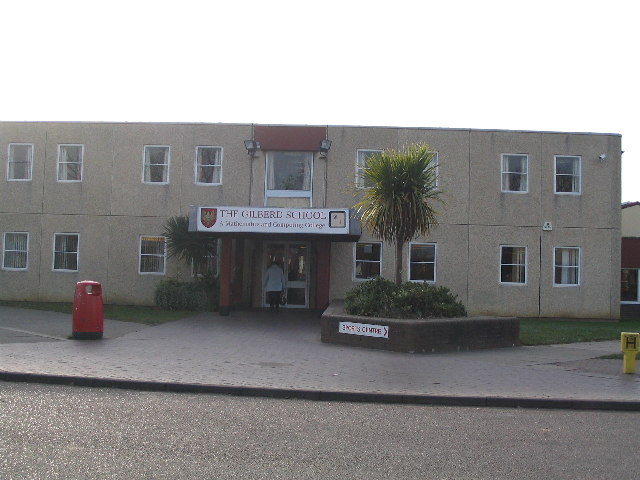
The Gilberd School

The Gilberd School is a coeducational secondary school with academy status, in Colchester, Essex, England. == History == The school originally opened on...

Welsh Wood

Welsh Wood is a 3.2 hectare Local Nature Reserve in Colchester in Essex. It is owned and managed by Colchester Borough Council.Trees in this site are managed...

Ipswich Road, Colchester

Ipswich Road, formally the A1232, is a road in Colchester, Essex, England. It was the historic coaching route and main road to Ipswich from the Middle...

St Aubyn Centre

The St Aubyn Centre is a mental health facility at 216 Turner Road, Colchester, Essex. It has two wards: (i) Longview Ward which is a General Adolescent...

Bull Meadow

Bull Neadow is a 1.4 hectare Local Nature Reserve in Colchester in Essex, owned and managed by Colchester Borough Council.The meadow is unimproved damp...

Colchester Hospital

Colchester Hospital is a district general hospital located in Colchester, Essex. It is managed by East Suffolk and North Essex NHS Foundation Trust....

Colchester Academy

Colchester Academy, formerly Sir Charles Lucas Arts College, is a secondary school in Colchester, Essex specialising in English and Health Sciences. It...

Nearby Amenities

Located within 500m of 51.905985,0.92845864
Crossing
Crossing: zebra
Lat/Long: 51.9090601/0.9274536
Post Box
Post Box Type: lamp
Ref: CO4 236
Royal Cypher: EIIR
Royal Cypher Wikidata: Q33102113
Lat/Long: 51.909106/0.9269481
Bus Stop
Rovers Tye
Bus: yes
Layby: yes
Naptan AtcoCode: 150033011001
Naptan Bearing: SE
Naptan CommonName: Rovers Tye
Naptan Indicator: Opp
Naptan Landmark: Rovers Tye
Naptan NaptanCode: esxajwjg
Naptan PlusbusZoneRef: CLCHSTR
Naptan Street: Highwoods Approach
Public Transport: platform
Shelter: yes
Source: naptan_import
Waste Basket: yes
Lat/Long: 51.9099902/0.9254186
Bus Stop
Eastwood Service Station
Bus: yes
Naptan AtcoCode: 150033016001
Naptan Bearing: NE
Naptan CommonName: Eastwood Service Station
Naptan Indicator: o/s
Naptan Landmark: Eastwood Service Station
Naptan NaptanCode: esxajwpg
Naptan PlusbusZoneRef: CLCHSTR
Naptan Street: Ipswich Road
Naptan Verified: no
Public Transport: platform
Source: naptan_import
Lat/Long: 51.9078467/0.9249663
Bus Stop
Eastwood Service Station
Bus: yes
Naptan AtcoCode: 150033016002
Naptan Bearing: S
Naptan CommonName: Eastwood Service Station
Naptan Indicator: Opp
Naptan Landmark: Eastwood Service Station
Naptan NaptanCode: esxajwpj
Naptan PlusbusZoneRef: CLCHSTR
Naptan Street: Ipswich Road
Naptan Verified: no
Public Transport: platform
Source: naptan_import
Lat/Long: 51.9075255/0.9250178
Bus Stop
Myland Hall Chase
Bus: yes
Naptan AtcoCode: 150033016003
Naptan Bearing: N
Naptan CommonName: Myland Hall Chase
Naptan Crossing: Myland Hall Chase
Naptan Indicator: Opp
Naptan Landmark: Myland Hall Chase
Naptan NaptanCode: esxajwpm
Naptan PlusbusZoneRef: CLCHSTR
Naptan Street: Ipswich Road
Naptan Verified: no
Public Transport: platform
Source: naptan_import
Lat/Long: 51.9059059/0.9241894
Bus Stop
Myland Hall Chase
Bus: yes
Naptan AtcoCode: 150033016004
Naptan Bearing: S
Naptan CommonName: Myland Hall Chase
Naptan Crossing: Myland Hall Chase
Naptan Indicator: Adj
Naptan Landmark: Myland Hall Chase
Naptan NaptanCode: esxajwpt
Naptan PlusbusZoneRef: CLCHSTR
Naptan Street: Ipswich Road
Naptan Verified: no
Public Transport: platform
Source: naptan_import
Lat/Long: 51.9053075/0.9243414
Bus Stop
St. Johns Post Office
Bus: yes
Layby: yes
Naptan AtcoCode: 150033016005
Naptan Bearing: S
Naptan CommonName: Post Office
Naptan Crossing: Friars Close
Naptan Indicator: o/s
Naptan Landmark: Post Office
Naptan NaptanCode: esxajwpw
Naptan PlusbusZoneRef: CLCHSTR
Naptan Street: Ipswich Road
Public Transport: platform
Shelter: yes
Source: naptan_import
Lat/Long: 51.9031579/0.9239811
Bus Stop
St. Johns Post Office
Bus: yes
Layby: yes
Naptan AtcoCode: 150033016006
Naptan Bearing: N
Naptan CommonName: Post Office
Naptan Crossing: Friars Close
Naptan Indicator: Opp
Naptan Landmark: Post Office
Naptan NaptanCode: esxapgjt
Naptan PlusbusZoneRef: CLCHSTR
Naptan Street: Ipswich Road
Public Transport: platform
Source: naptan_import
Waste Basket: yes
Lat/Long: 51.9031954/0.9237465
Bus Stop
Arden Close
Bus: yes
Naptan AtcoCode: 150033101002
Naptan Bearing: W
Naptan CommonName: Arden Close
Naptan Crossing: Arden Close
Naptan Indicator: Adj
Naptan Landmark: Arden Close
Naptan NaptanCode: esxamjag
Naptan PlusbusZoneRef: CLCHSTR
Naptan Street: St. John's Road
Public Transport: platform
Source: naptan_import
Lat/Long: 51.9090166/0.9285346
Bus Stop
St. John's Close
Bus: yes
Naptan AtcoCode: 150033101004
Naptan Bearing: NW
Naptan CommonName: St. John's Close
Naptan Crossing: St. John's Close
Naptan Indicator: Opp
Naptan Landmark: St. John's Close
Naptan NaptanCode: esxamjam
Naptan PlusbusZoneRef: CLCHSTR
Naptan Street: St. John's Road
Naptan Verified: no
Public Transport: platform
Source: naptan_import
Lat/Long: 51.9085477/0.932006
Bus Stop
Broad Oaks Park
Bus: yes
Naptan AtcoCode: 150033101005
Naptan Bearing: NW
Naptan CommonName: Broad Oaks Park
Naptan Indicator: Opp
Naptan Landmark: Broad Oaks Park
Naptan NaptanCode: esxamjat
Naptan PlusbusZoneRef: CLCHSTR
Naptan Street: St. John's Road
Public Transport: platform
Shelter: yes
Source: naptan_import
Timetable Case: yes
Lat/Long: 51.9063149/0.9336688
Bus Stop
Broad Oaks Park
Bus: yes
Naptan AtcoCode: 150033101006
Naptan Bearing: S
Naptan CommonName: Broad Oaks Park
Naptan Indicator: Adj
Naptan Landmark: Broad Oaks Park
Naptan NaptanCode: esxamjap
Naptan PlusbusZoneRef: CLCHSTR
Naptan Street: St. John's Road
Naptan Verified: no
Public Transport: platform
Source: naptan_import
Lat/Long: 51.9064731/0.9337206
Bus Stop
St. Christopher Road
Bus: yes
Naptan AtcoCode: 150033101007
Naptan Bearing: NW
Naptan CommonName: St. Christopher Road
Naptan Indicator: Adj
Naptan Landmark: St. Christopher Road
Naptan NaptanCode: esxamjaw
Naptan PlusbusZoneRef: CLCHSTR
Naptan Street: St. John's Road
Public Transport: platform
Source: naptan_import
Lat/Long: 51.9041349/0.9348622
Bus Stop
St. Columb Court
Bus: yes
Naptan AtcoCode: 150045001011
Naptan Bearing: N
Naptan BusStopType: CUS
Naptan CommonName: St. Columb Court
Naptan Indicator: Adj
Naptan Landmark: St. Columb Court
Naptan NaptanCode: esxjawmp
Naptan PlusbusZoneRef: CLCHSTR
Naptan Street: St. Cyrus Road
Public Transport: platform
Source: naptan_import
Lat/Long: 51.9037929/0.9278356
Belmont Crescent
Naptan AtcoCode: 150045001021
Naptan Bearing: NE
Naptan BusStopType: CUS
Naptan CommonName: Belmont Crescent
Naptan Crossing: Delamere Road
Naptan Indicator: NE-bound
Naptan Landmark: Belmont Crescent
Naptan NaptanCode: esxjawmt
Naptan PlusbusZoneRef: CLCHSTR
Naptan Street: St. Cyrus Road
Naptan Verified: no
Public Transport: platform
Source: naptan_import
Lat/Long: 51.9073597/0.9287877
Bus Stop
Delamere Road
Bus: yes
Naptan AtcoCode: 150045001022
Naptan Bearing: SE
Naptan BusStopType: CUS
Naptan CommonName: Delamere Road
Naptan Indicator: Adj
Naptan Landmark: Delamere Road
Naptan NaptanCode: esxjawmw
Naptan PlusbusZoneRef: CLCHSTR
Naptan Street: St. Cyrus Road
Public Transport: platform
Source: naptan_import
Lat/Long: 51.9084526/0.9297217
Bus Stop
Anthony Close
Bus: yes
Naptan AtcoCode: 1500DGK079
Naptan Bearing: E
Naptan CommonName: Anthony Close
Naptan Crossing: Anthony Close
Naptan Indicator: Opp
Naptan Landmark: Anthony Close
Naptan NaptanCode: esxgmgwg
Naptan PlusbusZoneRef: CLCHSTR
Naptan Street: St. Christopher Road
Naptan Verified: no
Public Transport: platform
Source: naptan_import
Lat/Long: 51.9033796/0.9333122
Bus Stop
St. Cyrus Road
Bus: yes
Naptan AtcoCode: 1500DGK082
Naptan Bearing: E
Naptan CommonName: St. Cyrus Road
Naptan Crossing: St. Cyrus Road
Naptan Indicator: Adj
Naptan Landmark: St. Cyrus Road
Naptan NaptanCode: esxgmgwp
Naptan PlusbusZoneRef: CLCHSTR
Naptan Street: St. Christopher Road
Naptan Verified: no
Public Transport: platform
Source: naptan_import
Lat/Long: 51.9029994/0.9283585
Bus Stop
Cloverlands
Bus: yes
Naptan AtcoCode: 1500DGK084
Naptan Bearing: S
Naptan CommonName: Cloverlands
Naptan Crossing: Cloverlands
Naptan Indicator: Adj
Naptan Landmark: Cloverlands
Naptan NaptanCode: esxgmjad
Naptan PlusbusZoneRef: CLCHSTR
Naptan Street: Upland Drive
Naptan Verified: no
Public Transport: platform
Source: naptan_import
Lat/Long: 51.9019627/0.9272507
Bus Stop
Arden Close
Bus: yes
Naptan AtcoCode: 1500IM141
Naptan Bearing: E
Naptan CommonName: Arden Close
Naptan Crossing: Arden Close
Naptan Indicator: Opp
Naptan Landmark: Arden Close
Naptan NaptanCode: esxamjad
Naptan PlusbusZoneRef: CLCHSTR
Naptan Street: St. John's Road
Public Transport: platform
Source: naptan_import
Timetable Case: yes
Lat/Long: 51.9090795/0.9282439
Bus Stop
St. John's Close
Bus: yes
Layby: yes
Naptan AtcoCode: 1500IM142
Naptan Bearing: SE
Naptan CommonName: St. John's Close
Naptan Crossing: St. John's Close
Naptan Indicator: Adj
Naptan Landmark: St. John's Close
Naptan NaptanCode: esxamjaj
Naptan PlusbusZoneRef: CLCHSTR
Naptan Street: St. John's Road
Public Transport: platform
Shelter: yes
Source: naptan_import
Timetable Case: yes
Waste Basket: yes
Lat/Long: 51.9091595/0.9312751
Bus Stop
Wilmington Road
Bus: yes
Naptan AtcoCode: 1500IM570
Naptan Bearing: N
Naptan CommonName: Wilmington Road
Naptan Crossing: Wilmington Road
Naptan Indicator: Adj
Naptan Landmark: Wilmington Road
Naptan NaptanCode: esxadawp
Naptan PlusbusZoneRef: CLCHSTR
Naptan Street: St. Cyrus Road
Public Transport: platform
Source: naptan_import
Lat/Long: 51.9053574/0.9279303
Bus Stop
Wilmington Road
Bus: yes
Naptan AtcoCode: 1500IM570B
Naptan Bearing: S
Naptan CommonName: Wilmington Road
Naptan Crossing: Wilmington Road
Naptan Indicator: Opp
Naptan Landmark: Wilmington Road
Naptan NaptanCode: esxadtwp
Naptan PlusbusZoneRef: CLCHSTR
Naptan Street: St. Cyrus Road
Public Transport: platform
Source: naptan_import
Lat/Long: 51.9053909/0.9280772
Bus Stop
St. John's Estate Shops
Bus: yes
Naptan AtcoCode: 1500IM571
Naptan Bearing: E
Naptan CommonName: St. John's Estate Shops
Naptan Crossing: St Monance Way
Naptan Indicator: o/s
Naptan Landmark: St. John's Estate Shops
Naptan NaptanCode: esxgmgwj
Naptan PlusbusZoneRef: CLCHSTR
Naptan Street: St. Christopher Road
Public Transport: platform
Source: naptan_import
Lat/Long: 51.902646/0.9306012
Post Box
Source: OS_opendata_streetview
Lat/Long: 51.9028737/0.9238853
Bus Stop
St. John's Estate Shops
Bus: yes
Naptan AtcoCode: 1500DGK081
Naptan Bearing: W
Naptan BusStopType: CUS
Naptan CommonName: St. John's Estate Shops
Naptan Crossing: St Dominic Road
Naptan Indicator: Opp
Naptan Landmark: St. John's Estate Shops
Naptan NaptanCode: esxgmgwm
Naptan PlusbusZoneRef: CLCHSTR
Naptan Street: St. Christopher Road
Naptan Verified: no
Public Transport: platform
Source: naptan_import
Lat/Long: 51.9026478/0.9294542
Crossing
Crossing: traffic_signals
Lat/Long: 51.9055551/0.9242594
Crossing
Crossing: zebra
Lat/Long: 51.9096147/0.9265637
Crossing
Lat/Long: 51.9089343/0.9259982
Crossing
Lat/Long: 51.9090013/0.9261938
Crossing
Crossing: zebra
Lat/Long: 51.9095902/0.9266723
DaRT St Johns
Naptan AtcoCode: 1500FLX602
Naptan NaptanCode: esxjmapa
Public Transport: platform
Lat/Long: 51.9043604/0.930214
Cafe
Wild Bean Cafe
Lat/Long: 51.9069829/0.9242959
M&S Simply Food
Brand: M&S Simply Food
Brand Wikidata: Q714491
Contact Website: https://www.marksandspencer.com/stores/colchester-eastwood-bp-2051
Shop: convenience
Lat/Long: 51.9069928/0.9242222
Car Wash
Lat/Long: 51.9067164/0.9239191
Post Office
St Johns Post Office
Addr Postcode: CO4 0HW
Branch: St Johns
Brand: Post Office
Brand Wikidata: Q1783168
Check Date: 2020-02-20
Contact Website: https://www.postoffice.co.uk/branch-finder/1071165/st-johns
Ref Pol Id: 1490
Lat/Long: 51.902816/0.9241323
Entrance: main
Lat/Long: 51.9028036/0.9301163
Atm
Lat/Long: 51.9028094/0.9300734
Entrance: main
Lat/Long: 51.902883/0.9296805
Atm
Lat/Long: 51.902878/0.9297127
Waste Basket
Waste: dog_excrement
Lat/Long: 51.9072782/0.9284969
Waste Basket
Lat/Long: 51.9090777/0.9291252
Waste Basket
Waste: dog_excrement
Lat/Long: 51.9065692/0.9260541
Post Box
Post Box Type: pillar
Royal Cypher: EIIR
Royal Cypher Wikidata: Q33102113
Lat/Long: 51.9080129/0.9326389
Barrier: cycle_barrier
Lat/Long: 51.9056632/0.9306917
Barrier: cycle_barrier
Lat/Long: 51.9059643/0.9327114
Barrier: cycle_barrier
Lat/Long: 51.9062142/0.933677
Waste Basket
Lat/Long: 51.9085764/0.9274368
Post Box
Post Box Type: pillar
Ref: CO4 442D
Royal Cypher: EIIR
Royal Cypher Wikidata: Q33102113
Lat/Long: 51.906383/0.92787
Waste Basket
Waste: dog_excrement
Lat/Long: 51.9053909/0.9268521
Barrier: cycle_barrier
Lat/Long: 51.9053818/0.9278553
Waste Basket
Lat/Long: 51.9053996/0.9280725
Waste Basket
Lat/Long: 51.9027233/0.9301606
Bicycle Parking
Capacity: 12
Lat/Long: 51.9027084/0.9301887
Waste Basket
Lat/Long: 51.9026761/0.9303993
Post Box
Post Box Type: pillar
Royal Cypher: EIIR
Royal Cypher Wikidata: Q33102113
Lat/Long: 51.9027109/0.9303845
Bench
Lat/Long: 51.9026927/0.9303913
Barrier: cycle_barrier
Lat/Long: 51.9026845/0.9306518
Waste Basket
Lat/Long: 51.9029575/0.9305964
Waste Basket
Waste: dog_excrement
Lat/Long: 51.9032587/0.9306608
Waste Basket
Lat/Long: 51.904993/0.9320998
Barrier: cycle_barrier
Lat/Long: 51.9047596/0.9321964
Generator Location: roof
Generator Method: photovoltaic
Generator Orientation: SSE
Generator Output Electricity: yes
Generator Source: solar
Generator Type: solar_photovoltaic_panel
Power: generator
Source: ESRI World Imagery
Lat/Long: 51.9041214/0.9236545
Home
Name Ru: дом
Tourism: guest_house
Lat/Long: 51.9070225/0.925087
Tuition
Jacqui Robinson Education Centre
Operator: Jacqui Robinson
Website: https://www.jacquirobinsoneducation.co.uk/
Lat/Long: 51.906356/0.9238679
Speed Camera
Direction: 200
Maxspeed: 30 mph
Lat/Long: 51.9043641/0.9241553
Defibrillator
Access: customers
Defibrillator Location: on wall beyond tills facing you as you enter the store
Emergency: defibrillator
Indoor: yes
Ref GB The Circuit: 4E506F37-8054-4E3D-B656-AE370070D213
Lat/Long: 51.9029719/0.929716
Defibrillator
Access: yes
Defibrillator Location: on post to left of driveway gates when viewed from Uplands Drive
Emergency: defibrillator
Indoor: no
Ref GB The Circuit: 8AAF7EB8-A5FF-4E5A-942E-AE1900D8829E
Lat/Long: 51.9025135/0.9270841
Defibrillator
Access: yes
Defibrillator Location: on wall of pub facing shops opposite
Emergency: defibrillator
Indoor: no
Ref GB The Circuit: 27F228D5-E76F-4E2F-A25A-AE190123EE08
Lat/Long: 51.9024498/0.9294847
The data included in this document is from www.openstreetmap.org. The data is made available under ODbL.

Have you been to Magdalen Wood?

Leave your review of Magdalen Wood below (or comments, questions and feedback).