Ash Carr

Wood, Forest in Norfolk Breckland

England

Ash Carr

Green Forest Track Forest track through forest that is marked on the map as Hills And Holes near to Great Hockham, Norfolk.
Green Forest Track Credit: Keith Evans

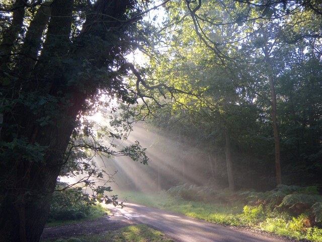
Ash Carr is a small woodland area located in Norfolk, a county in the East of England. Situated within the larger expanse of Norfolk Forest, Ash Carr is known for its dense growth of ash trees, which dominate the landscape and give the area its name.

Covering an approximate area of 50 acres, Ash Carr is a picturesque woodland that attracts nature enthusiasts and outdoor adventurers alike. The ash trees create a canopy that provides shade and shelter, making it a pleasant place to explore even on hot summer days. The forest floor is rich in vegetation, with wildflowers, ferns, and mosses adding to the visual appeal of the area.

The woodland is home to a variety of wildlife, making it a popular spot for birdwatching and nature photography. Visitors may spot species such as woodpeckers, owls, and various songbirds among the trees. Small mammals like squirrels, rabbits, and foxes can also be observed in their natural habitat.

Ash Carr is a peaceful retreat for those seeking solitude or a place for quiet reflection. It offers several walking trails that wind through the trees, allowing visitors to immerse themselves in the natural beauty and tranquility of the area. The woodland is well-maintained, with clear paths and occasional benches where visitors can rest and enjoy the surroundings.

Overall, Ash Carr is a charming woodland in Norfolk, offering a serene escape from the hustle and bustle of everyday life. Its lush vegetation, diverse wildlife, and well-maintained trails make it a delightful destination for nature lovers and anyone seeking a peaceful connection with the outdoors.

If you have any feedback on the listing, please let us know in the comments section below.

Ash Carr Images

Images are sourced within 2km of 52.487544/0.84719234 or Grid Reference TL9391. Thanks to Geograph Open Source API. All images are credited.

Green Forest Track Forest track through forest that is marked on the map as Hills And Holes near to Great Hockham, Norfolk.
Green Forest Track
Forest track through forest that is marked on the map as Hills And Holes near to Great Hockham, Norfolk.
Footpath Junction Footpath junction and five bar gate at Illington, Norfolk.
Footpath Junction
Footpath junction and five bar gate at Illington, Norfolk.
Footpath Looking West Footpath looking west near to Illington, Norfolk.
Footpath Looking West
Footpath looking west near to Illington, Norfolk.
Gas Line Marker Gas pipeline marker near to Illington, Norfolk.
Gas Line Marker
Gas pipeline marker near to Illington, Norfolk.
Track Junction Track and footpath junction near to Illington, Norfolk.
Track Junction
Track and footpath junction near to Illington, Norfolk.
Bambridge Lane Marked on the map as Bambridge Lane seen here north of Illington, Norfolk.
Bambridge Lane
Marked on the map as Bambridge Lane seen here north of Illington, Norfolk.
Bend In Track Track leading to Little Hockham near to Illington, Norfolk.
Bend In Track
Track leading to Little Hockham near to Illington, Norfolk.
Little Hockham Footpath sign and Little London near to Illington, Norfolk.
Little Hockham
Footpath sign and Little London near to Illington, Norfolk.
Country Lane Country leading to Little Hockham, Norfolk.
Country Lane
Country leading to Little Hockham, Norfolk.
Holy Trinity; the parish church of Great Hockham This church stands quite alone to the southwest of the village.  It lost its tower in the 19th century and was replaced by the present bell-tower in 1854.
Holy Trinity; the parish church of Great Hockham
This church stands quite alone to the southwest of the village. It lost its tower in the 19th century and was replaced by the present bell-tower in 1854.
Forest Track Forest track near to Stonebridge, Norfolk.
Forest Track
Forest track near to Stonebridge, Norfolk.
Green Road Country Road near to Stonebridge, Norfolk.
Green Road
Country Road near to Stonebridge, Norfolk.
Country Lane Country lane and forest track entrance near to Stonebridge, Norfolk.
Country Lane
Country lane and forest track entrance near to Stonebridge, Norfolk.
Poor's Allotment This open land is marked on the map as Poor's Allotment near to Breckles, Norfolk.
Poor's Allotment
This open land is marked on the map as Poor's Allotment near to Breckles, Norfolk.
Green Track Green forest track near to Breckles, Norfolk.
Green Track
Green forest track near to Breckles, Norfolk.
Forest Track Forest track looking north towards Frost's Common near to Breckles, Norfolk.
Forest Track
Forest track looking north towards Frost's Common near to Breckles, Norfolk.
Country lane in the woods near to Great Hockham Early morning sun beams through the trees in the woods near Great Hockham, close to part of the Peddars Way.
Country lane in the woods near to Great Hockham
Early morning sun beams through the trees in the woods near Great Hockham, close to part of the Peddars Way.
Morning sunlight through the trees at Stonebridge Taken in Hockham woods near to Stonebridge and part of the Peddars Way
Morning sunlight through the trees at Stonebridge
Taken in Hockham woods near to Stonebridge and part of the Peddars Way
Show me another place!

Ash Carr is located at Grid Ref: TL9391 (Lat: 52.487544, Lng: 0.84719234)

Administrative County: Norfolk

District: Breckland

Police Authority: Norfolk

What 3 Words

///group.dreaming.occupy. Near East Harling, Norfolk

Related Wikis

Wretham and Hockham railway station

Wretham and Hockham railway station was a station in Norfolk serving the villages of Wretham and Hockham. It was on the Great Eastern Railway branch line...

Stonebridge, Norfolk

Stonebridge is a village in the English county of Norfolk. It is situated on the A1075 road, some 6 miles (9.7 km) north east of the town of Thetford and...

East Wretham Windmill

East Wretham Mill is a tower mill at East Wretham, Norfolk, England which has been converted to residential accommodation. == History == East Wretham...

Great Eastern Pingo Trail

Great Eastern Pingo Trail is a 9.2 kilometres (5.7 miles) long footpath along a disused railway line north of Thetford in Norfolk. It is a 4.2-hectare...

Thompson Water, Carr and Common

Thompson Water, Carr and Common is a 154.7-hectare (382-acre) biological Site of Special Scientific Interest north of Thetford in Norfolk. Most of it is...

Cranberry Rough, Hockham

Cranberry Rough is an 81.1-hectare (200-acre) biological and geological Site of Special Scientific Interest in the parish of Hockham, east of Attleborough...

Battle of Ringmere

The Battle of Ringmere was fought on 5 May 1010. Norse sagas recorded a battle at Hringmaraheiðr; Old English Hringmere-hǣð, modern name Ringmere Heath...

Illington

Illington is a village and former civil parish, now in the parish of Wretham in the Breckland district, in the county of Norfolk, England. The village...

Nearby Amenities

Located within 500m of 52.487544,0.84719234
Crossing
Crossing: unmarked
Lat/Long: 52.489373/0.848816
Crossing
Crossing: unmarked
Lat/Long: 52.4877725/0.8523474
Bragmere Pits
Place: locality
Lat/Long: 52.4895861/0.8475233
Barrier: bar
Foot: yes
Vehicle: no
Lat/Long: 52.4892841/0.8490036
Description: Black NNW arrow on yellow circle
Hiking: yes
Information: route_marker
Inscription: Wildlife Trail / Breaking New Ground / Supported by The Heritage Lottery Fund
Material: wood
Operator: Norfolk Trails
Tourism: information
Lat/Long: 52.4914514/0.8460961
Wildlife Trail
Hiking: yes
Information: route_marker
Inscription: Breaking New Ground / Supported by The Heritage Lottery Fund / Public Footpath
Material: wood
Operator: Norfolk Trails;Norfolk County Council
Tourism: information
Lat/Long: 52.4878821/0.8520868
Actuator: manual
Colour: black
Handle: no
Location: overground
Marker: post
Material: metal
Pipeline: valve
Ref: TL9900
Utility: gas
Valve: butterfly
Lat/Long: 52.4893148/0.849127
East Wretham Circular Walk
Hiking: yes
Information: guidepost
Inscription: Wildlife Trail / Breaking New Ground / Supported by The Heritage Lottery Fund / Public Footpath / HLF Landscape Partnership / Restricted Byway
Material: wood
Operator: Norfolk Trails
Tourism: information
Lat/Long: 52.4893036/0.8489168
Description: Black arrow on cycle circle
Hiking: yes
Information: route_marker
Material: wood
Tourism: information
Lat/Long: 52.4913289/0.8477578
Description: Black arrow on cycle circle
Hiking: yes
Information: route_marker
Material: wood
Tourism: information
Lat/Long: 52.4911954/0.8509228
The data included in this document is from www.openstreetmap.org. The data is made available under ODbL.

Have you been to Ash Carr?

Leave your review of Ash Carr below (or comments, questions and feedback).