Flemptonbridge Carr

Wood, Forest in Suffolk West Suffolk

England

Flemptonbridge Carr

West Stow: Field used for grazing
West Stow: Field used for grazing Credit: Michael Garlick

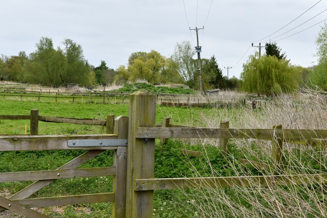
Flemptonbridge Carr is a picturesque wood located in Suffolk, England. Spread across a vast area, this forest is known for its stunning natural beauty and diverse flora and fauna. The word "Carr" refers to a wet woodland or boggy area, and Flemptonbridge Carr lives up to this definition with its marshy terrain and waterlogged ground.

This woodland is home to an array of tree species, including oak, beech, birch, and willow. The dense canopy formed by these trees creates a cool and shady environment, perfect for leisurely walks or nature exploration. The forest floor is adorned with a vibrant carpet of wildflowers, ferns, and mosses, adding to the enchanting atmosphere.

Flemptonbridge Carr is not only a haven for plant life but also a sanctuary for various animal species. Bird enthusiasts will be delighted to spot a variety of feathered creatures, such as woodpeckers, owls, and warblers, among others. The wetland areas provide an ideal habitat for amphibians and reptiles, including frogs, toads, and grass snakes.

Visitors to Flemptonbridge Carr can enjoy a tranquil and serene experience, immersing themselves in the sounds of nature and the breathtaking scenery. The forest offers several walking trails, allowing visitors to explore its different areas and discover hidden gems along the way. It is also a popular spot for nature photography and wildlife observation.

Overall, Flemptonbridge Carr is a remarkable woodland that showcases the beauty and diversity of Suffolk's natural landscape. It offers a peaceful retreat for nature lovers and a chance to connect with the wonders of the great outdoors.

If you have any feedback on the listing, please let us know in the comments section below.

Flemptonbridge Carr Images

Images are sourced within 2km of 52.300994/0.66505928 or Grid Reference TL8170. Thanks to Geograph Open Source API. All images are credited.

West Stow: Field used for grazing
Wordwell, All Saints Church: The nave
Wordwell, All Saints Church: Norman font on unusual three-legged support
Wordwell, All Saints Church: Bench end 1
Wordwell, All Saints Church: Bench end 2
Wordwell, All Saints Church: Bench end 3
Wordwell, All Saints Church: Bench end 4
Wordwell, All Saints Church: Bench end 5
Wordwell, All Saints Church: Bench end 6
Wordwell, All Saints Church: Bench end 7
Wordwell, All Saints Church: Bench end 8
Wordwell, All Saints Church: Bench end 9
Wordwell, All Saints Church: Bench end 10
Wordwell, All Saints Church: Norman font
Wordwell, All Saints Church: The nave and Norman font
Wordwell, All Saints Church: Poppy head 1
Wordwell, All Saints Church: The altar
Show me another place!

Flemptonbridge Carr is located at Grid Ref: TL8170 (Lat: 52.300994, Lng: 0.66505928)

Administrative County: Suffolk

District: West Suffolk

Police Authority: Suffolk

What 3 Words

///dormant.split.airbase. Near Bury St Edmunds, Suffolk

Related Wikis

West Stow

West Stow is a small village and civil parish in West Suffolk, England. The village lies north of Bury St. Edmunds, south of Mildenhall and Thetford and...

West Stow Hall

West Stow Hall is a Tudor manor house in West Stow, Suffolk, England, near Bury St Edmunds. It was begun in around 1520 for Sir John Croftes, Master of...

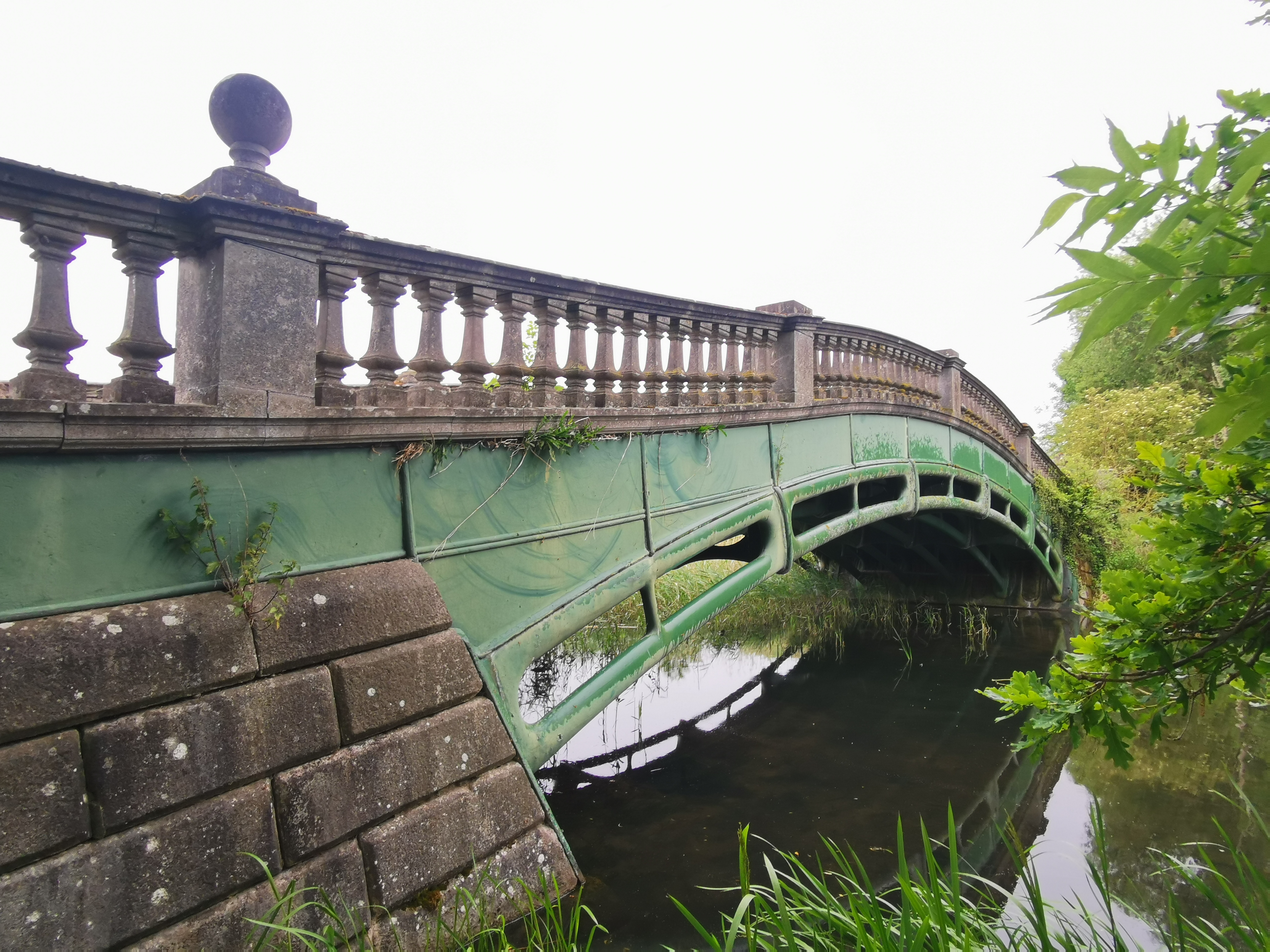
The Iron Bridge, Culford Park

The Iron Bridge is a grade I listed early cast iron bridge crossing a tributary of the River Lark in grounds of Culford Park in the village of Culford...

Flempton

Flempton is a village and civil parish in the West Suffolk district of Suffolk, England. It is on the A1101 road 5 miles NW from Bury St Edmunds. Flempton...

Nearby Amenities

Located within 500m of 52.300994,0.66505928
Bus Stop
Icklingham Road
Naptan AtcoCode: 390050605
Naptan Bearing: S
Naptan CommonName: Icklingham Road
Naptan Indicator: opp
Naptan Landmark: Icklingham Road
Naptan NaptanCode: sufgjdmg
Naptan Street: Ingham Road
Naptan Verified: no
Source: naptan_import
Lat/Long: 52.3043841/0.6686645
Icklingham Road
Naptan AtcoCode: 390050606
Naptan Bearing: N
Naptan BusStopType: CUS
Naptan CommonName: Icklingham Road
Naptan Indicator: adj
Naptan Landmark: Icklingham Road
Naptan NaptanCode: sufgjdmj
Naptan Street: Ingham Road
Naptan Verified: no
Source: naptan_import
Lat/Long: 52.3044671/0.6685701
Power: pole
Lat/Long: 52.3017018/0.658241
Power: pole
Lat/Long: 52.2995974/0.6640453
Power: pole
Lat/Long: 52.2982705/0.6659148
Power: pole
Lat/Long: 52.3016969/0.6593943
Power: pole
Lat/Long: 52.2976635/0.6669367
Power: pole
Lat/Long: 52.2989331/0.6649814
Power: pole
Lat/Long: 52.2969697/0.6677949
Power: pole
Lat/Long: 52.3010261/0.6621892
Power: pole
Lat/Long: 52.3009687/0.6621033
Power: pole
Lat/Long: 52.2976061/0.6668482
Power: pole
Lat/Long: 52.3016149/0.6582517
Power: pole
Lat/Long: 52.2996548/0.6641418
Power: pole
Lat/Long: 52.2990086/0.6650484
Power: pole
Lat/Long: 52.2970025/0.6678673
Power: pole
Lat/Long: 52.2983393/0.6659872
Power: pole
Lat/Long: 52.300347/0.6631279
Power: pole
Lat/Long: 52.3013574/0.6609339
Power: pole
Lat/Long: 52.3013115/0.6607837
Power: pole
Lat/Long: 52.3003011/0.6630555
Power: pole
Lat/Long: 52.3018035/0.6593621
Power: pole
Lat/Long: 52.2993828/0.6598607
Power: pole
Lat/Long: 52.298661/0.6592975
Power: pole
Lat/Long: 52.2990252/0.6595335
Barrier: stile
Lat/Long: 52.3047427/0.6650349
Post Box
Collection Times: Mo-Fr 16:00; Sa 09:00
Post Box Mounting: wall
Post Box Type: wall
Ref: IP28 2037
Royal Cypher: EIIR
Royal Cypher Wikidata: Q33102113
Lat/Long: 52.3049632/0.6633993
Barrier: stile
Lat/Long: 52.3017986/0.6635731
West Stowe
Man Made: village_sign
Lat/Long: 52.3044648/0.6685301
Bus Stop
Lat/Long: 52.3027809/0.6682917
Barrier: kissing_gate
Lat/Long: 52.3030149/0.6683139
Bench
Lat/Long: 52.3024539/0.6719792
The data included in this document is from www.openstreetmap.org. The data is made available under ODbL.

Have you been to Flemptonbridge Carr?

Leave your review of Flemptonbridge Carr below (or comments, questions and feedback).