Atherstone

Settlement in Somerset South Somerset

England

Atherstone

Whitelackington Village Hall
Whitelackington Credit: Liz Martin

Atherstone is a small village located in Somerset, England. Situated near the border of Devon, it lies within the district of West Somerset. The village has a population of around 500 residents and is known for its picturesque setting and tranquil atmosphere.

Atherstone is surrounded by rolling hills and stunning countryside, making it a popular destination for nature lovers and hikers. The village is also blessed with a rich history, with evidence of human habitation dating back to the Iron Age. Several archaeological sites have been discovered in the area, including ancient burial mounds and Roman remains.

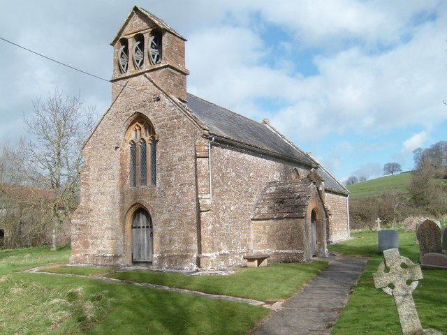
The heart of the village is dominated by St. Mary’s Church, a beautiful medieval building that serves as a focal point for the community. The church is known for its impressive architecture and stunning stained glass windows, attracting visitors from far and wide.

Despite its small size, Atherstone boasts a thriving community spirit. The village has a primary school, a village hall, and a local pub, which serves as a meeting place for residents. Regular community events and activities take place throughout the year, fostering a strong sense of belonging and camaraderie among the villagers.

Atherstone is conveniently located near major transport links, with easy access to the nearby town of Minehead and the stunning Exmoor National Park. The village offers a peaceful retreat for those seeking a slower pace of life, surrounded by natural beauty and a close-knit community.

If you have any feedback on the listing, please let us know in the comments section below.

Atherstone Images

Images are sourced within 2km of 50.943775/-2.87664 or Grid Reference ST3816. Thanks to Geograph Open Source API. All images are credited.

Whitelackington Village Hall
Whitelackington
Village Hall
Stocklinch Ottersey church Remote from its village
Stocklinch Ottersey church
Remote from its village
Puckington: Gummer’s Lane A track and public footpath to Stocklinch. Possibly an old way as it defines the parish boundary with Stocklinch. Looking south east
Puckington: Gummer’s Lane
A track and public footpath to Stocklinch. Possibly an old way as it defines the parish boundary with Stocklinch. Looking south east
Ilton: drainage channel On the river Isle flood plain near Ilford Bridge. In north Somerset this channel would be called a rhine. Looking south east
Ilton: drainage channel
On the river Isle flood plain near Ilford Bridge. In north Somerset this channel would be called a rhine. Looking south east
St Andrews Church Puckington A lovely church set well back from the road, easily missed.
St Andrews Church Puckington
A lovely church set well back from the road, easily missed.
Church Notice Board Puckington
Park Lane On the right is Putcombe Copse, which was the site of a C16 deerpark, part of Whitelackington Park. The lane leads to Kingstone.
Park Lane
On the right is Putcombe Copse, which was the site of a C16 deerpark, part of Whitelackington Park. The lane leads to Kingstone.
Hurcott Copse Between the camera and the wooded slopes the A303 lies hidden. In the foreground, Park Lane meets the former main road from Ilminster to Yeovil, now downgraded to unclassified.
Hurcott Copse
Between the camera and the wooded slopes the A303 lies hidden. In the foreground, Park Lane meets the former main road from Ilminster to Yeovil, now downgraded to unclassified.
St Mary's Church, Whitelackington The church is very close to the manor house, and consequently difficult to photograph from the south. <span class="nowrap"><a title="http://webapp1.somerset.gov.uk/her/details.asp?prn=53358" rel="nofollow ugc noopener" href="http://webapp1.somerset.gov.uk/her/details.asp?prn=53358">Link</a><img style="margin-left:2px;" alt="External link" title="External link - shift click to open in new window" src="https://s1.geograph.org.uk/img/external.png" width="10" height="10"/></span>
St Mary's Church, Whitelackington
The church is very close to the manor house, and consequently difficult to photograph from the south. LinkExternal link
Dillington Park A view from the long drive that approaches Dillington House from Whitelackington.
Dillington Park
A view from the long drive that approaches Dillington House from Whitelackington.
Dillington Park Farm The farm lies in the landscape park of Dillington House. A workshop among the buildings houses a firm of cabinet makers. See also <a href="https://www.geograph.org.uk/photo/1307455">ST3715 : Fishing lake, Dillington</a>.
Dillington Park Farm
The farm lies in the landscape park of Dillington House. A workshop among the buildings houses a firm of cabinet makers. See also ST3715 : Fishing lake, Dillington.
Dillington House Another view of the west facade of <a href="https://www.geograph.org.uk/photo/11185">ST3615 : Dillington House</a>. Architectural details at <span class="nowrap"><a title="http://webapp1.somerset.gov.uk/her/details.asp?prn=56603" rel="nofollow ugc noopener" href="http://webapp1.somerset.gov.uk/her/details.asp?prn=56603">Link</a><img style="margin-left:2px;" alt="External link" title="External link - shift click to open in new window" src="https://s1.geograph.org.uk/img/external.png" width="10" height="10"/></span> , and notes on its use during World War Two at <span class="nowrap"><a title="http://webapp1.somerset.gov.uk/her/details.asp?prn=15029" rel="nofollow ugc noopener" href="http://webapp1.somerset.gov.uk/her/details.asp?prn=15029">Link</a><img style="margin-left:2px;" alt="External link" title="External link - shift click to open in new window" src="https://s1.geograph.org.uk/img/external.png" width="10" height="10"/></span> .
Dillington House
Another view of the west facade of ST3615 : Dillington House. Architectural details at LinkExternal link , and notes on its use during World War Two at LinkExternal link .
Sculpture at Dillington House The wooden figure (unable to trace any details so far) is beside footpath CH14/14 as it passes Dillington House in the background, and is one of several pieces of artwork in the grounds, doubtless related to the many art-related courses run at the centre.
Sculpture at Dillington House
The wooden figure (unable to trace any details so far) is beside footpath CH14/14 as it passes Dillington House in the background, and is one of several pieces of artwork in the grounds, doubtless related to the many art-related courses run at the centre.
The Pheasantry One of the outbuildings at Dillington House. (Those holes look more suitable for doves than pheasants, although this building may date from between the C17 extinction of the bird and its reintroduction in the C19.)
The Pheasantry
One of the outbuildings at Dillington House. (Those holes look more suitable for doves than pheasants, although this building may date from between the C17 extinction of the bird and its reintroduction in the C19.)
The Mews, Dillington House The former stable block at <a href="https://www.geograph.org.uk/photo/492365">ST3615 : Dillington House</a> dates from a later era. See
<span class="nowrap"><a title="http://webapp1.somerset.gov.uk/her/details.asp?prn=56602" rel="nofollow ugc noopener" href="http://webapp1.somerset.gov.uk/her/details.asp?prn=56602">Link</a><img style="margin-left:2px;" alt="External link" title="External link - shift click to open in new window" src="https://s1.geograph.org.uk/img/external.png" width="10" height="10"/></span>
The Mews, Dillington House
The former stable block at ST3615 : Dillington House dates from a later era. See LinkExternal link
Dillington Park Lodge The thatched C17/C18 house is beside the former main road through Whitelackington. Details at <span class="nowrap"><a title="http://webapp1.somerset.gov.uk/her/details.asp?prn=56612" rel="nofollow ugc noopener" href="http://webapp1.somerset.gov.uk/her/details.asp?prn=56612">Link</a><img style="margin-left:2px;" alt="External link" title="External link - shift click to open in new window" src="https://s1.geograph.org.uk/img/external.png" width="10" height="10"/></span> .
Dillington Park Lodge
The thatched C17/C18 house is beside the former main road through Whitelackington. Details at LinkExternal link .
Emergency access slip road to A303 The busy Ilminster bypass runs for 7 miles between junctions, so emergency access routes such as this could be vital. This one is off Boxstone Hill, the lane on the lane, which leads to Shepton Beauchamp.
Emergency access slip road to A303
The busy Ilminster bypass runs for 7 miles between junctions, so emergency access routes such as this could be vital. This one is off Boxstone Hill, the lane on the lane, which leads to Shepton Beauchamp.
Junction east of Whitelackington Park Lane approaches the junction shown in <a href="https://www.geograph.org.uk/photo/491867">ST3915 : Hurcott Copse</a>. Left for Ilminster, right for Seavington St Michael.
Junction east of Whitelackington
Park Lane approaches the junction shown in ST3915 : Hurcott Copse. Left for Ilminster, right for Seavington St Michael.
Show me another place!

Atherstone is located at Grid Ref: ST3816 (Lat: 50.943775, Lng: -2.87664)

Administrative County: Somerset

District: South Somerset

Police Authority: Avon and Somerset

What 3 Words

///pipe.physical.coasting. Near Ilminster, Somerset

Nearby Locations

Atherstone Hill Atherstone

Related Wikis

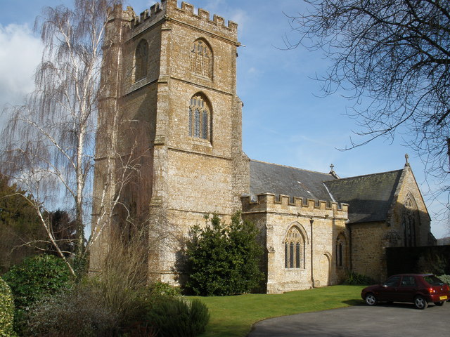
Church of St Mary Magdalene, Stocklinch

The Church of St Mary Magdalen in Stocklinch, Somerset, England, dates from the 13th century. It is recorded in the National Heritage List for England...

Whitelackington

Whitelackington is a village and civil parish on the A303 one mile north east of Ilminster, in Somerset, England. The parish includes Dillington Park and...

Stocklinch

Stocklinch is a village and civil parish 3.5 miles (6 km) north-east of Ilminster in the South Somerset district of Somerset, England. == History == The...

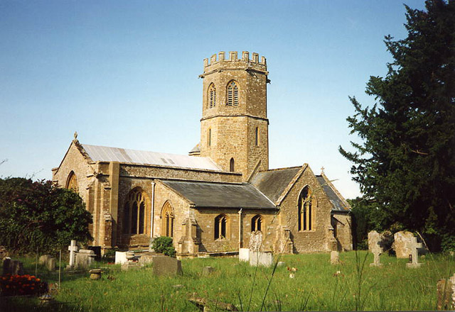
Church of St Mary the Virgin, Whitelackington

The Anglican Church of St Mary the Virgin in Whitelackington, Somerset, England was built in the 14th and 15th centuries. It is a Grade II* listed building...

Hurcott Lane Cutting

Hurcott Lane Cutting (grid reference ST398163) is a 0.48 hectare geological Site of Special Scientific Interest in Somerset, notified in 1996. == Sources... ==

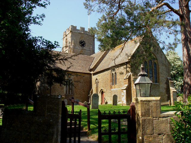
Church of St Mary the Virgin, Barrington

The Church of St Mary the Virgin in Barrington, Somerset, England dates from the 13th century and has been designated as a Grade I listed building.St Mary...

Dillington House

Dillington House is a residential adult education college near Ilminster in the parish of Whitelackington, Somerset, England. The present house, which...

Church of St Andrew, Puckington

The Anglican Church of St Andrew in Puckington, Somerset, England, was built in the 13th century. It is a Grade II* listed building. == History == The...

Nearby Amenities

Located within 500m of 50.943775,-2.87664
Atherstone
Place: hamlet
Lat/Long: 50.9448317/-2.879384
Power: pole
Lat/Long: 50.9399435/-2.8790939
Power: pole
Lat/Long: 50.9406669/-2.8793299
Power: pole
Lat/Long: 50.9414612/-2.8796196
Power: pole
Lat/Long: 50.942019/-2.8822213
Power: pole
Lat/Long: 50.9421102/-2.8809232
Power: pole
Lat/Long: 50.942188/-2.8798932
Power: pole
Lat/Long: 50.9422556/-2.8787828
Power: pole
Lat/Long: 50.9423468/-2.8775704
Power: pole
Lat/Long: 50.9424381/-2.8763795
Power: pole
Lat/Long: 50.942526/-2.8752154
Power: pole
Lat/Long: 50.9426274/-2.8740084
Power: pole
Lat/Long: 50.942695/-2.8729677
Power: pole
Lat/Long: 50.9427913/-2.8717017
Power: pole
Lat/Long: 50.9428454/-2.8708729
Power: pole
Lat/Long: 50.9429316/-2.8698483
The data included in this document is from www.openstreetmap.org. The data is made available under ODbL.

Have you been to Atherstone?

Leave your review of Atherstone below (or comments, questions and feedback).