Gover's Grove

Wood, Forest in Cambridgeshire South Cambridgeshire

England

Gover's Grove

Tuffill's Plantation A footpath from High Noon Farm runs along the eastern side of this field, passing to the right of the plantation ahead.
Tuffill's Plantation Credit: Bob Jones

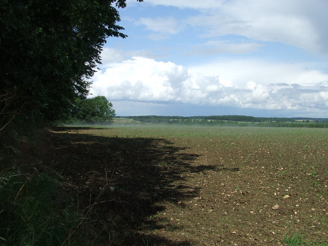
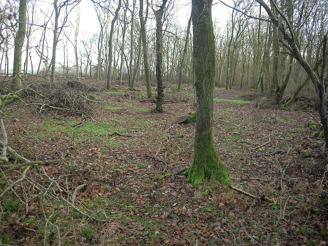
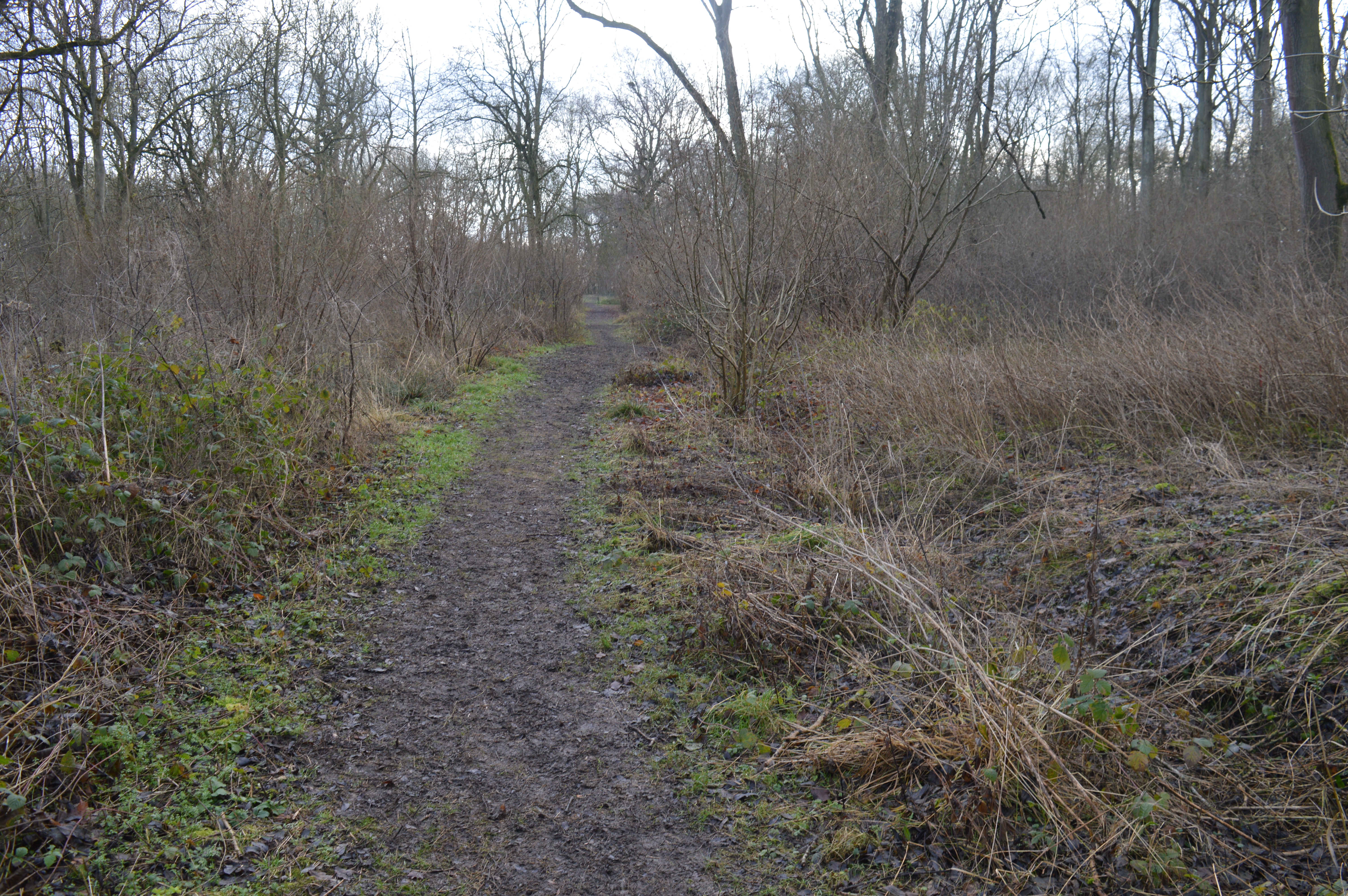
Gover's Grove is a serene woodland located in Cambridgeshire, England. This picturesque forest spans an area of approximately 100 acres and is renowned for its natural beauty and diverse ecosystem. The grove is situated on the outskirts of the village of Goverton, providing locals and visitors with a peaceful escape from the bustling city life.

The woodland is primarily composed of majestic oak and beech trees, which tower above the forest floor and create a dense canopy that filters the sunlight. This creates a tranquil and shaded atmosphere, perfect for leisurely walks or picnics. The forest floor is adorned with a vibrant carpet of ferns, wildflowers, and moss, adding to the enchanting ambiance of the grove.

Gover's Grove is home to a rich array of wildlife. Squirrels gracefully dart between the trees, while various species of birds, including woodpeckers and owls, can be spotted perched on branches or soaring above the treetops. The grove also provides a habitat for small mammals such as hedgehogs and foxes.

The forest boasts a network of well-maintained trails, allowing visitors to explore its natural wonders. These paths wind through the woodland, offering captivating views of the flora and fauna. Additionally, there are designated picnic areas and benches strategically placed throughout the grove, providing ample opportunities for visitors to relax and soak in the tranquil surroundings.

Gover's Grove is a cherished natural gem in Cambridgeshire, providing a haven of biodiversity and tranquility for nature enthusiasts and those seeking solace in the great outdoors.

If you have any feedback on the listing, please let us know in the comments section below.

Gover's Grove Images

Images are sourced within 2km of 52.133809/0.40805853 or Grid Reference TL6451. Thanks to Geograph Open Source API. All images are credited.

Tuffill's Plantation A footpath from High Noon Farm runs along the eastern side of this field, passing to the right of the plantation ahead.
Tuffill's Plantation
A footpath from High Noon Farm runs along the eastern side of this field, passing to the right of the plantation ahead.
Footpath at Cadge's Wood Many of the tracks in this area are of concrete, reflecting the nearby WW2 airfield at Wratting Common, which was operational between 1943 and 1945. The footpath leads to Withersfield Church.
Footpath at Cadge's Wood
Many of the tracks in this area are of concrete, reflecting the nearby WW2 airfield at Wratting Common, which was operational between 1943 and 1945. The footpath leads to Withersfield Church.
A Cambridgeshire crossroads Straight on for West Wratting, left for West Wickham, Horseheath and Balsham, right for Carlton (and the RAF Wratting Green memorial).
A Cambridgeshire crossroads
Straight on for West Wratting, left for West Wickham, Horseheath and Balsham, right for Carlton (and the RAF Wratting Green memorial).
Furniture store in a former RAF hangar Home Brands is based in one of the hangars of RAF Wratting Common, a Bomber Command Station during the Second World War. For more about RAF Wratting, see <span class="nowrap"><a title="http://www.wcnhistory.org.uk/overview.html" rel="nofollow ugc noopener" href="http://www.wcnhistory.org.uk/overview.html">Link</a><img style="margin-left:2px;" alt="External link" title="External link - shift click to open in new window" src="https://s1.geograph.org.uk/img/external.png" width="10" height="10"/></span> .
Furniture store in a former RAF hangar
Home Brands is based in one of the hangars of RAF Wratting Common, a Bomber Command Station during the Second World War. For more about RAF Wratting, see LinkExternal link .
Jelly Warehouse Jelly Warehouse is based in one of the hangars of RAF Wratting Common, a Bomber Command Station during the Second World War. For more about RAF Wratting, see the very thorough <span class="nowrap"><a title="http://www.wcnhistory.org.uk/overview.html" rel="nofollow ugc noopener" href="http://www.wcnhistory.org.uk/overview.html">Link</a><img style="margin-left:2px;" alt="External link" title="External link - shift click to open in new window" src="https://s1.geograph.org.uk/img/external.png" width="10" height="10"/></span> .
Jelly Warehouse
Jelly Warehouse is based in one of the hangars of RAF Wratting Common, a Bomber Command Station during the Second World War. For more about RAF Wratting, see the very thorough LinkExternal link .
Carlton: churchyard light and shade Taken from shaded Carlton Green Road on a sunny October morning. St Peter's is a small and rewarding church: see, for instance, <a href="https://www.geograph.org.uk/photo/3143308">TL6452 : Carlton: St Peter - font</a>, <a href="https://www.geograph.org.uk/photo/3143323">TL6452 : Carlton: St Peter - south window</a> and <a href="https://www.geograph.org.uk/photo/3143339">TL6452 : Carlton: St Peter - interior</a>, taken ten years before.
Carlton: churchyard light and shade
Taken from shaded Carlton Green Road on a sunny October morning. St Peter's is a small and rewarding church: see, for instance, TL6452 : Carlton: St Peter - font, TL6452 : Carlton: St Peter - south window and TL6452 : Carlton: St Peter - interior, taken ten years before.
Autumn rolling A tractor pulling a huge disc roller, photographed from the road from Carlton Green to Carlton on a sunny October morning.
Autumn rolling
A tractor pulling a huge disc roller, photographed from the road from Carlton Green to Carlton on a sunny October morning.
On the road to Carlton Between Carlton Green and Carlton on a sunny October morning.
On the road to Carlton
Between Carlton Green and Carlton on a sunny October morning.
Carlton Green: once a pub The red-roofed cottage was once a public house.
Carlton Green: once a pub
The red-roofed cottage was once a public house.
Towards Carlton Green A straight stretch of the winding road from Little Thurlow.
Towards Carlton Green
A straight stretch of the winding road from Little Thurlow.
Nearing Temple End Plantation A short stretch of the Little Thurlow to Carlton Green road forms the county boundary: Suffolk and Temple End Plantation are to the left, Cambridgeshire to the right.
Nearing Temple End Plantation
A short stretch of the Little Thurlow to Carlton Green road forms the county boundary: Suffolk and Temple End Plantation are to the left, Cambridgeshire to the right.
A farm track on the county boundary Cambridgeshire to the left of the hedge, Suffolk to the right.
A farm track on the county boundary
Cambridgeshire to the left of the hedge, Suffolk to the right.
A single-track road on the edge of Suffolk The narrow lane from Little Thurlow in Suffolk to Carlton Green in Cambridgeshire, photographed on a lovely October morning.
A single-track road on the edge of Suffolk
The narrow lane from Little Thurlow in Suffolk to Carlton Green in Cambridgeshire, photographed on a lovely October morning.
Uphill from Temple End The road from Little Thurlow to Carlton Green and Weston Colville, over the county boundary in Cambridgeshire. The Suffolk County Council notice explains that these are wildlife verges, cut only in winter to encourage wild flowers and biodiversity.
Uphill from Temple End
The road from Little Thurlow to Carlton Green and Weston Colville, over the county boundary in Cambridgeshire. The Suffolk County Council notice explains that these are wildlife verges, cut only in winter to encourage wild flowers and biodiversity.
Barn and bend at Temple End The Dutch barn is sheltering straw bales. Keith Edkins came this way in 2018: <a href="https://www.geograph.org.uk/photo/5922417">TL6650 : Barn on Temple End Farm</a>.
Barn and bend at Temple End
The Dutch barn is sheltering straw bales. Keith Edkins came this way in 2018: TL6650 : Barn on Temple End Farm.
Temple End: Low Farm Temple End Stream, a tributary of the Stour, passes under the road here.
Temple End: Low Farm
Temple End Stream, a tributary of the Stour, passes under the road here.
Temple End: the road to Little Thurlow The shallow valley of Temple End Stream, a tributary of the Stour, photographed on a fine October morning.
Temple End: the road to Little Thurlow
The shallow valley of Temple End Stream, a tributary of the Stour, photographed on a fine October morning.
Mist Mist on a summer's day, the aftermath of a quick heavy rain shower near to Withersfield, Suffolk.
Mist
Mist on a summer's day, the aftermath of a quick heavy rain shower near to Withersfield, Suffolk.
Show me another place!

Gover's Grove is located at Grid Ref: TL6451 (Lat: 52.133809, Lng: 0.40805853)

Administrative County: Cambridgeshire

District: South Cambridgeshire

Police Authority: Cambridgeshire

What 3 Words

///extremely.unrealistic.affirming. Near Haverhill, Suffolk

Related Wikis

RAF Wratting Common

Royal Air Force Wratting Common, or more simply RAF Wratting Common, is a former Royal Air Force substation located near Newmarket, Suffolk, UK. ��2�...

Carlton Wood

Carlton Wood is a 10.4-hectare (26-acre) biological Site of Special Scientific Interest on the eastern boundary of Cambridgeshire, and west of Great Bradley...

Carlton, Cambridgeshire

Carlton is a village and civil parish near the eastern boundary of the county of Cambridgeshire in the east of England. It is in the district of South...

Great Bradley

Great Bradley is a village and civil parish in the West Suffolk district of Suffolk in eastern England. According to Eilert Ekwall the meaning of the village...

Collis Mill, Great Thurlow

Collis Mill is a Grade II* listed smock mill at Great Thurlow, Suffolk, England, which has been restored. == History == Collis Mill was originally built...

Over and Lawn Woods

Over and Lawn Woods is a 43.3-hectare (107-acre) biological Site of Special Scientific Interest north-west of Haverhill in Suffolk. It is listed by Natural...

Lower Wood

Lower Wood is a 9 hectare nature reserve east of Weston Colville in Cambridgeshire. It is managed by the Wildlife Trust for Bedfordshire, Cambridgeshire...

Little Bradley

Little Bradley is a small village and civil parish in the West Suffolk district, in the county of Suffolk, England. According to Eilert Ekwall, the meaning...

Nearby Amenities

Located within 500m of 52.133809,0.40805853
The data included in this document is from www.openstreetmap.org. The data is made available under ODbL.

Have you been to Gover's Grove?

Leave your review of Gover's Grove below (or comments, questions and feedback).