Felpham

Settlement in Sussex Arun

England

Felpham

Hotham Park House Hotham Park is an area of 9 hectares (22 acres) located in the High Street, Bognor Regis. It is the only large park in the town. 

It first became a public park on 1st January 1947, having been purchased by the former Bognor Regis urban District Council from the executors of the late William Fletcher.   <span class="nowrap"><a title="http://www.hothampark.co.uk/index.html" rel="nofollow ugc noopener" href="http://www.hothampark.co.uk/index.html">Link</a><img style="margin-left:2px;" alt="External link" title="External link - shift click to open in new window" src="https://s1.geograph.org.uk/img/external.png" width="10" height="10"/></span>
Hotham Park House Credit: PAUL FARMER

Felpham is a picturesque village located on the southern coast of England, in the county of Sussex. Situated approximately six miles east of the historic town of Chichester, Felpham is nestled between the English Channel to the south and the South Downs National Park to the north.

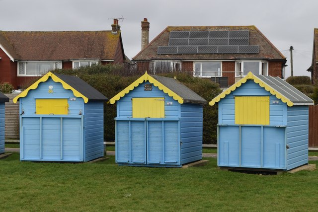
Known for its stunning natural beauty, Felpham boasts a pebble beach that stretches for miles, offering breathtaking views of the sea and the nearby Isle of Wight. The village itself is characterized by charming thatched cottages, quaint streets, and a peaceful atmosphere that has attracted both tourists and residents seeking a tranquil seaside retreat.

Felpham is also notable for its historical significance. It was here where the renowned English poet William Blake lived and wrote his famous poem, "Jerusalem." Today, a plaque commemorates his time in the village, and visitors can explore the Blake Cottage, which has been beautifully restored and converted into a museum.

The village offers a range of amenities, including a variety of shops, cafes, and traditional pubs, where visitors can sample local cuisine and enjoy a pint of traditional Sussex ale. Additionally, Felpham is home to several recreational facilities, such as tennis courts, a leisure center, and a golf course, providing opportunities for both residents and visitors to stay active and enjoy outdoor activities.

With its natural beauty, rich history, and tranquil atmosphere, Felpham is a hidden gem on the Sussex coast, offering a peaceful haven for those seeking a break from the hustle and bustle of city life.

If you have any feedback on the listing, please let us know in the comments section below.

Felpham Images

Images are sourced within 2km of 50.793195/-0.642938 or Grid Reference SU9500. Thanks to Geograph Open Source API. All images are credited.

Hotham Park House Hotham Park is an area of 9 hectares (22 acres) located in the High Street, Bognor Regis. It is the only large park in the town. 

It first became a public park on 1st January 1947, having been purchased by the former Bognor Regis urban District Council from the executors of the late William Fletcher.   <span class="nowrap"><a title="http://www.hothampark.co.uk/index.html" rel="nofollow ugc noopener" href="http://www.hothampark.co.uk/index.html">Link</a><img style="margin-left:2px;" alt="External link" title="External link - shift click to open in new window" src="https://s1.geograph.org.uk/img/external.png" width="10" height="10"/></span>
Hotham Park House
Hotham Park is an area of 9 hectares (22 acres) located in the High Street, Bognor Regis. It is the only large park in the town. It first became a public park on 1st January 1947, having been purchased by the former Bognor Regis urban District Council from the executors of the late William Fletcher. LinkExternal link
Promenade and Pebbly Beach Promenade and pebbly beach by the Felpham Beach Huts
Promenade and Pebbly Beach
Promenade and pebbly beach by the Felpham Beach Huts
Promenade and Pebbly Beach Promenade and pebbly beach by the bridleway onto the Summerley Estate
Promenade and Pebbly Beach
Promenade and pebbly beach by the bridleway onto the Summerley Estate
Coastal Path Coastal path passing the Middleton on Sea Association beach huts on the Greensward  <span class="nowrap"><a title="https://www.mosassociation.org/beach-huts" rel="nofollow ugc noopener" href="https://www.mosassociation.org/beach-huts">Link</a><img style="margin-left:2px;" alt="External link" title="External link - shift click to open in new window" src="https://s1.geograph.org.uk/img/external.png" width="10" height="10"/></span>
Coastal Path
Coastal path passing the Middleton on Sea Association beach huts on the Greensward LinkExternal link
Felpham, St Mary the Virgin
Felpham Beach Seen from the promenade east of Longbrook Park.
Felpham Beach
Seen from the promenade east of Longbrook Park.
Environment Agency pumps installed at Longbrook Two pumps were installed in November 2023 to increase flood resilience by allowing water to be pumped from the brook through the two large pipes, over the sea defences and promenade and discharged into the sea. See also <a href="https://www.geograph.org.uk/photo/7702619">SZ9499 : Flood defence discharge pipes</a>.
Environment Agency pumps installed at Longbrook
Two pumps were installed in November 2023 to increase flood resilience by allowing water to be pumped from the brook through the two large pipes, over the sea defences and promenade and discharged into the sea. See also SZ9499 : Flood defence discharge pipes.
Flood defence discharge pipes This is the seaward end of the pipes from <a href="https://www.geograph.org.uk/photo/7702616">SZ9499 : Environment Agency pumps installed at Longbrook</a>.
Flood defence discharge pipes
This is the seaward end of the pipes from SZ9499 : Environment Agency pumps installed at Longbrook.
Long queue at The Lobster Pot Lots of people waiting for Sunday lunch at this seafood restaurant on the promenade at Felpham.
Long queue at The Lobster Pot
Lots of people waiting for Sunday lunch at this seafood restaurant on the promenade at Felpham.
Yellow and blue beach huts at Felpham
Felpham Beach A pebble beach with many groynes.
Felpham Beach
A pebble beach with many groynes.
Beach huts and houses on the seafront at Felpham As seen from the promenade.
Beach huts and houses on the seafront at Felpham
As seen from the promenade.
Miniature train and carriage shed, Hotham Park That locomotive is not any kind of scale model, but was definitely influenced by the design of  a British Railways Class 33 in 1960s livery! Compare <a href="https://www.geograph.org.uk/photo/6064674">SZ0278 : 1960s railway scene recreated at Swanage</a>.
Miniature train and carriage shed, Hotham Park
That locomotive is not any kind of scale model, but was definitely influenced by the design of a British Railways Class 33 in 1960s livery! Compare SZ0278 : 1960s railway scene recreated at Swanage.
Slipway covered by pebbles Wave action has caused the beach to pile up higher than the promenade, completely burying this slipway.
Slipway covered by pebbles
Wave action has caused the beach to pile up higher than the promenade, completely burying this slipway.
On the promenade at Felpham
Beach view at Hannah's Groyne
Benches on the greensward at Middleton-on-Sea
Seafront houses at Middleton-on-Sea
Show me another place!

Felpham is located at Grid Ref: SU9500 (Lat: 50.793195, Lng: -0.642938)

Administrative County: West Sussex

District: Arun

Police Authority: Sussex

What 3 Words

///from.costs.fallen. Near Bognor Regis, West Sussex

Nearby Locations

Felpham Felpham

Related Wikis

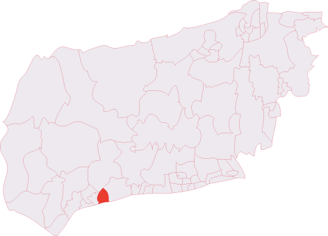
Felpham (electoral division)

Felpham is an electoral division of West Sussex in the United Kingdom and returns one member to sit on West Sussex County Council. == Extent == The division...

Felpham

Felpham (/ˈfelpəm/, sometimes pronounced locally as Felf-fm or Fel-thm) is a village and civil parish in the Arun District of West Sussex, England. Although...
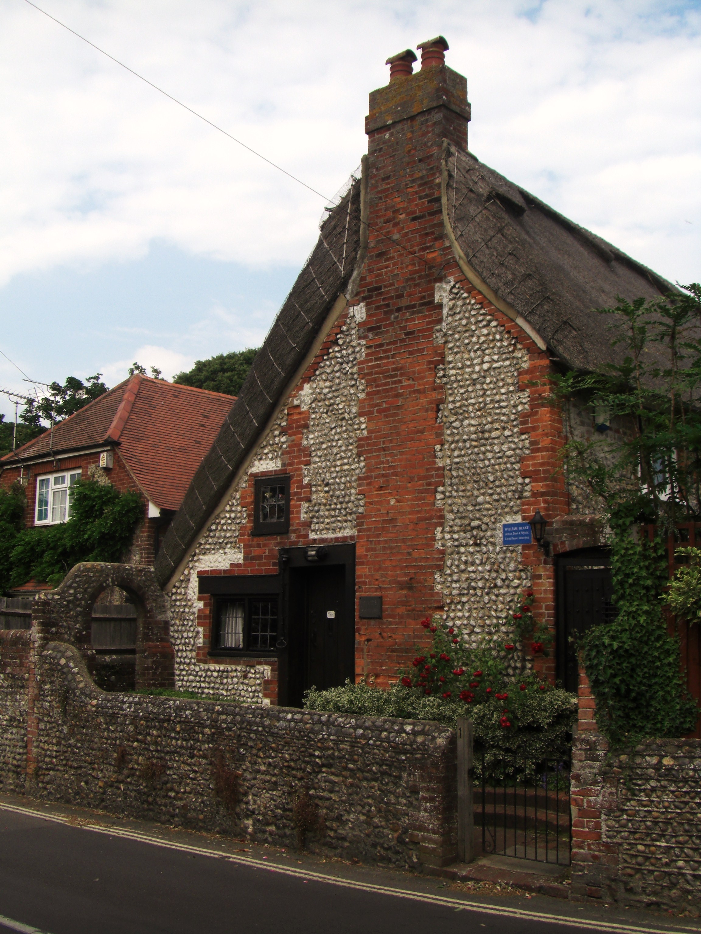
Blake's Cottage

Blake's Cottage stands in the village of Felpham, West Sussex. The house dates from the 17th century. Its name commemorates the occupancy of the poet William...

Felpham Community College

== History == Until the 1970s, students from primary schools in the village of Felpham attended secondary schools in the nearby town of Bognor Regis. A...

Related Videos

Littlehampton to Bognor Regis | South Coast Walks | Cool Dudes Walking Club

swcwalks #swcwalk212 An 8-mile walk along the South Coast from Littlehampton to Bognor Regis. This walk is from the excellent ...

BOGNOR REGIS Beach and Seafront Tour

BOGNOR REGIS Beach and Seafront Tour to take a look at this holiday seaside town on the South Coast between Worthing and ...

BOGNOR REGIS | Exploring the holiday seaside town of Bognor Regis

Bognor Regis is a charming seaside town located between Brighton and Bournemouth in West Sussex, England. Try Readly, with ...

Butlins Holiday - Day trip to Brighton in windy conditions - Globalls & Brighton Pier

We stay at Butlins in the silver apartments for only £69, This is day 3 of our Butlins holiday, Today we took a trip to Brighton for a ...

Nearby Amenities

Located within 500m of 50.793195,-0.642938
Mini Roundabout
Direction: clockwise
Lat/Long: 50.793392/-0.6429989
Felpham Bikes
Service Bicycle Repair: yes
Shop: bicycle
Lat/Long: 50.793947/-0.6400539
Traffic Signals
Crossing: traffic_signals
Crossing Ref: pelican
Traffic Signals: signal
Lat/Long: 50.7934246/-0.6427349
Bus Stop
Firs Ave
Bench: no
Bin: yes
Bus: yes
Naptan AtcoCode: 4400LH0594
Naptan Bearing: E
Naptan CommonName: Firs Ave
Naptan Indicator: Adj Firs Ave
Naptan Landmark: Firs Avenue
Naptan NaptanCode: wsxdgmat
Naptan Street: Felpham Way
Naptan Verified: no
Public Transport: platform
Shelter: no
Source: naptan_import
Lat/Long: 50.7933603/-0.6442473
Bus Stop
Firs Ave
Bench: yes
Bus: yes
Naptan AtcoCode: 4400LH0595
Naptan Bearing: W
Naptan CommonName: Firs Ave
Naptan Indicator: Opp Firs Ave
Naptan Landmark: Firs Avenue
Naptan NaptanCode: wsxdgmaw
Naptan Street: Felpham Way
Naptan Verified: no
Public Transport: platform
Shelter: yes
Source: naptan_import
Lat/Long: 50.7932653/-0.6435676
Bus Stop
Southdowns
Alt Name: National Express Stop
Bench: yes
Bin: yes
Bus: yes
Naptan AltCommonName: National Express Stop
Naptan AltStreet: Not Specified
Naptan AtcoCode: 4400LH0596
Naptan Bearing: W
Naptan CommonName: Southdowns
Naptan Indicator: adj
Naptan Landmark: Clovelly Avenue
Naptan NaptanCode: wsxdgmda
Naptan Street: Felpham Way
Naptan Verified: no
Public Transport: platform
Shelter: yes
Source: naptan_import
Lat/Long: 50.7938118/-0.639471
Bus Stop
Southdowns
Alt Name: National Express Stop
Bench: no
Bin: no
Bus: yes
Naptan AltCommonName: National Express Stop
Naptan AltStreet: Not Specified
Naptan AtcoCode: 4400LH0597
Naptan Bearing: E
Naptan CommonName: Southdowns
Naptan Indicator: o/s Southdowns PH
Naptan Landmark: Clovelly Avenue
Naptan NaptanCode: wsxdgmdg
Naptan Street: Felpham Way
Naptan Verified: no
Public Transport: platform
Shelter: yes
Source: naptan_import
Lat/Long: 50.794038/-0.638877
Bus Stop
Firs Avenue West
Bus: yes
Naptan AtcoCode: 4400LH0724
Naptan Bearing: N
Naptan BusStopType: CUS
Naptan CommonName: Firs Avenue West
Naptan Indicator: adj
Naptan Landmark: Hail & Ride
Naptan NaptanCode: wsxdtjda
Naptan Street: Firs Avenue
Naptan Verified: no
Public Transport: platform
Source: naptan_import
Lat/Long: 50.7946287/-0.6432585
Bus Stop
Westmorland Drive
Bus: yes
Naptan AtcoCode: 4400LH0725
Naptan Bearing: W
Naptan BusStopType: CUS
Naptan CommonName: Westmorland Drive
Naptan Indicator: opp
Naptan Landmark: Hail & Ride
Naptan NaptanCode: wsxdtjdg
Naptan Street: Outerwyke Road
Naptan Verified: no
Public Transport: platform
Source: naptan_import
Lat/Long: 50.7962574/-0.6464325
Bus Stop
Westmorland Drive
Bus: yes
Naptan AtcoCode: 4400LH0977
Naptan Bearing: E
Naptan BusStopType: CUS
Naptan CommonName: Westmorland Drive
Naptan Indicator: adj
Naptan Landmark: Hail and Ride
Naptan Street: Outerwyke Road
Naptan Verified: no
Public Transport: platform
Source: naptan_import
Lat/Long: 50.7963005/-0.6462751
Bus Stop
Firs Avenue West
Bus: yes
Naptan AtcoCode: 4400LH0978
Naptan Bearing: S
Naptan BusStopType: CUS
Naptan CommonName: Firs Avenue West
Naptan Indicator: opp
Naptan Landmark: Hail and Ride
Naptan Street: Firs Avenue
Naptan Verified: no
Public Transport: platform
Source: naptan_import
Lat/Long: 50.7946089/-0.643103
Post Box
Ref: PO22 50D
Lat/Long: 50.7937975/-0.639594
Turning Circle
Lat/Long: 50.7905911/-0.644959
Turning Circle
Surface: asphalt
Lat/Long: 50.7944291/-0.6406387
Post Office
Summerley Post Office
Addr City: Bognor Regis
Addr Country: GB
Addr Postcode: PO22 7HX
Addr Street: Summerley Lane
Addr Village: Felpham
Brand: Post Office
Brand Wikidata: Q1783168
Contact Website: https://www.postoffice.co.uk/branch-finder/2269376/summerley
Opening Hours: Mo-Su 09:00-18:00
Operator: Central
Ref Pol Id: 8631
Lat/Long: 50.7905412/-0.6427646
Barrier: bollard
Lat/Long: 50.7934745/-0.6375706
Post Box
Collection Times: Mo-Fr 17:30; Sa 11:30
Post Box Type: pillar
Ref: PO22 49
Royal Cypher: GR
Royal Cypher Wikidata: Q33102273
Lat/Long: 50.7904045/-0.6425244
Post Box
Brand: Royal Mail
Brand Wikidata: Q638098
Brand Wikipedia: en:Royal Mail
Collection Plate: CP7D
Collection Times: Mo-Fr 09:00; Sa 07:00
Operator: Royal Mail
Operator Wikidata: Q638098
Post Box Type: lamp
Ref: PO22 85D
Royal Cypher: EIIR
Royal Cypher Wikidata: Q33102113
Lat/Long: 50.7971411/-0.6445983
Addr Housenumber: 24
Lat/Long: 50.7942036/-0.6453404
Addr Housenumber: 34
Lat/Long: 50.7941104/-0.6455404
Addr Housenumber: 4
Lat/Long: 50.7945184/-0.6461742
Addr Housenumber: 27
Lat/Long: 50.7939323/-0.6455114
Londis
Addr City: Felpham
Addr Housenumber: 97
Addr Postcode: PO22 8QB
Addr Street: Felpham Way
Brand: Londis
Brand Wikidata: Q21008564
Fhrs Authority: Arun
Fhrs Id: 1384576
Fhrs Local Authority Id: 9103547
Phone: +44 1243 587455
Shop: convenience
Lat/Long: 50.7937413/-0.6422249
Crossing
Crossing: zebra
Lat/Long: 50.7940428/-0.6377967
Mini Roundabout
Lat/Long: 50.794257/-0.6376384
Barrier: bollard
Lat/Long: 50.7927798/-0.6409918
Barrier: bollard
Lat/Long: 50.7911091/-0.6421255
Post Box
Post Box Type: pillar
Ref: PO22 5
Royal Cypher: EIIR
Royal Cypher Wikidata: Q33102113
Lat/Long: 50.7932606/-0.6436102
Restaurant
India Raj
Addr City: Bognor Regis
Addr County: West Sussex
Addr Housename: So India
Addr Housenumber: 43
Addr Postcode: PO22 8PT
Addr Street: Felpham Way
Addr Suburb: Felpham
Cuisine: indian
Fhrs Authority: Arun
Fhrs Id: 1552219
Fhrs Local Authority Id: 9104087
Opening Hours: Mo-Su 12:00-14:30,17:00-23:00
Source Addr: FHRS Open Data
Website: https://www.soindiafelpham.co.uk
Lat/Long: 50.792542/-0.6479464
Traffic Calming: island
Lat/Long: 50.7933134/-0.642982
Traffic Signals
Crossing: traffic_signals
Crossing Ref: pelican
Traffic Signals: signal
Lat/Long: 50.7940171/-0.6384087
Barrier: bollard
Lat/Long: 50.7915445/-0.6494612
Bench
Backrest: yes
Lat/Long: 50.7923751/-0.6410678
Leisure: picnic_table
Lat/Long: 50.7935973/-0.6383814
Leisure: picnic_table
Lat/Long: 50.7936534/-0.6383195
Leisure: picnic_table
Lat/Long: 50.7936903/-0.6382868
Bench
Backrest: no
Lat/Long: 50.7935479/-0.638532
Traffic Calming: bump
Lat/Long: 50.7954395/-0.6392006
Crossing: informal
Lat/Long: 50.7930938/-0.6397413
Waste Basket
Lat/Long: 50.7937969/-0.6395458
Bench
Backrest: yes
Lat/Long: 50.7908423/-0.6382904
Bench
Backrest: yes
Lat/Long: 50.7925091/-0.63888
Bench
Lat/Long: 50.7938617/-0.638222
Barrier: bollard
Lat/Long: 50.7904646/-0.6433491
Crossing
Crossing: unmarked
Crossing Island: no
Lat/Long: 50.7940587/-0.6365774
Bench
Lat/Long: 50.7924288/-0.6407046
Waste Basket
Waste: dog_excrement
Lat/Long: 50.7916469/-0.6494628
Man Made: manhole
Manhole: drain
Lat/Long: 50.7935427/-0.6397796
Man Made: manhole
Manhole: drain
Lat/Long: 50.7936491/-0.6397196
Man Made: manhole
Manhole: drain
Lat/Long: 50.7938173/-0.6398657
Man Made: manhole
Manhole: drain
Lat/Long: 50.7938771/-0.6398345
Man Made: manhole
Manhole: telecom
Lat/Long: 50.7938049/-0.6398076
Man Made: manhole
Manhole: drain
Lat/Long: 50.7938681/-0.6399951
Man Made: manhole
Manhole: drain
Lat/Long: 50.7937206/-0.6403722
Man Made: manhole
Manhole: drain
Lat/Long: 50.7937882/-0.6404811
Man Made: manhole
Manhole: drain
Lat/Long: 50.7936407/-0.6409412
Man Made: manhole
Manhole: drain
Lat/Long: 50.793707/-0.6409424
Man Made: manhole
Manhole: telecom
Lat/Long: 50.7936278/-0.6409503
Man Made: manhole
Manhole: drain
Lat/Long: 50.7936003/-0.6411159
Man Made: manhole
Manhole: drain
Lat/Long: 50.7935816/-0.6410742
Man Made: manhole
Manhole: telecom
Lat/Long: 50.7935327/-0.641433
Man Made: manhole
Manhole: drain
Lat/Long: 50.7936278/-0.6414775
Man Made: manhole
Manhole: telecom
Lat/Long: 50.7934695/-0.641798
Man Made: manhole
Manhole: drain
Lat/Long: 50.7934863/-0.6417621
Man Made: manhole
Manhole: telecom
Lat/Long: 50.7935997/-0.6416535
Man Made: manhole
Manhole: telecom
Lat/Long: 50.7935457/-0.6422287
Traffic Calming: island
Lat/Long: 50.7933764/-0.6432284
Barrier: bollard
Lat/Long: 50.7904337/-0.6426862
Barrier: bollard
Lat/Long: 50.7904555/-0.6426768
Barrier: bollard
Lat/Long: 50.7904755/-0.6426659
Barrier: bollard
Lat/Long: 50.7904932/-0.6426598
Barrier: bollard
Lat/Long: 50.7905115/-0.6426542
Waste Basket
Operator: Arun District Council
Lat/Long: 50.7905887/-0.6425393
Board Type: notice
Information: board
Tourism: information
Lat/Long: 50.7905971/-0.6425825
Bicycle Parking
Bicycle Parking: stands
Capacity: 3
Lat/Long: 50.793993/-0.6380585
Waste Basket
Lat/Long: 50.7939945/-0.6380185
Atm
RBS
Brand: RBS
Brand Wikidata: Q160126
Brand Wikipedia: en:Royal Bank of Scotland
Currency GBP: yes
Drive Through: no
Fee: no
Indoor: no
Official Name: Royal Bank of Scotland
Opening Hours: 24/7
Operator: RBS
Operator Wikidata: Q160126
Lat/Long: 50.7939825/-0.6377949
Barrier: bollard
Lat/Long: 50.7934637/-0.6374811
Waste Basket
Waste: dog_excrement
Lat/Long: 50.7935261/-0.6376621
Waste Basket
Lat/Long: 50.7936383/-0.6383593
Bench
Lat/Long: 50.7921958/-0.6423879
Waste Basket
Lat/Long: 50.7922003/-0.6424808
Waste Basket
Waste: dog_excrement
Lat/Long: 50.7921903/-0.6424808
Summerley Private Estate
Information: guidepost
Tourism: information
Lat/Long: 50.79004/-0.6424987
Board Type: notice
Information: board
Tourism: information
Lat/Long: 50.7899943/-0.6424116
Bench
Backrest: yes
Lat/Long: 50.7913491/-0.6420645
Waste Basket
Waste: dog_excrement
Lat/Long: 50.7911377/-0.6420589
Waste Basket
Lat/Long: 50.7911444/-0.6420368
Grit Bin
Lat/Long: 50.790393/-0.642531
Waste Basket
Check Date: 2024-04-20
Lat/Long: 50.792696/-0.6408843
Waste Basket
Lat/Long: 50.7935172/-0.6384632
Man Made: manhole
Manhole: drain
Lat/Long: 50.7934112/-0.6397811
Man Made: manhole
Manhole: drain
Lat/Long: 50.7934379/-0.6397007
Bench
Backrest: yes
Lat/Long: 50.7913816/-0.6379563
Bench
Backrest: yes
Lat/Long: 50.79102/-0.639992
Waste Basket
Lat/Long: 50.7923178/-0.6410088
Board Type: notice
Information: board
Tourism: information
Lat/Long: 50.7938224/-0.6393297
Stop
Direction: backward
Lat/Long: 50.7899879/-0.6425574
Stop
Direction: forward
Lat/Long: 50.7899665/-0.6428751
Waste Basket
Waste: dog_excrement
Lat/Long: 50.7908161/-0.6381469
Waste Basket
Lat/Long: 50.7908334/-0.6381409
Bench
Backrest: yes
Lat/Long: 50.7922322/-0.6379488
Waste Basket
Lat/Long: 50.792387/-0.63782
Playground: swing
Lat/Long: 50.7936737/-0.6385352
Playground: swing
Lat/Long: 50.7936318/-0.6385237
Playground: slide
Lat/Long: 50.7937112/-0.6384035
Playground: roundabout
Lat/Long: 50.7938159/-0.6385791
Playground: climbingframe
Lat/Long: 50.7938821/-0.6386015
Playground: climbingframe
Lat/Long: 50.7938494/-0.6384636
Playground: springy
Lat/Long: 50.793794/-0.6382784
Playground: springy
Lat/Long: 50.7938141/-0.6383288
Playground: seesaw
Lat/Long: 50.7937414/-0.6383549
Information: board
Tourism: information
Lat/Long: 50.7971874/-0.6420363
Waste Basket
Description: Dog waste bin only
Lat/Long: 50.7972658/-0.6415288
Waste Basket
Lat/Long: 50.7926139/-0.6425978
Traffic Mirror
Lat/Long: 50.7898457/-0.6421501
Drinking Water
Lat/Long: 50.7938441/-0.6380948
Post Box
Brand: Royal Mail
Brand Wikidata: Q638098
Brand Wikipedia: en:Royal Mail
Collection Plate: CP7D
Collection Times: Mo-Fr 09:00; Sa 07:00
Operator: Royal Mail
Operator Wikidata: Q638098
Post Box Type: lamp
Ref: PO22 87D
Royal Cypher: EIIR
Royal Cypher Wikidata: Q33102113
Lat/Long: 50.7969791/-0.639414
Waste Basket
Lat/Long: 50.7938454/-0.6381973
Access: private
Barrier: bollard
Bicycle: yes
Bollard: rising
Colour: Grey with Lights
Description: Road close, private estate access for RRA residents only.
Foot: yes
Height: 0.8
Horse: yes
Material: metal
Motor Vehicle: permit
Width: 2.3
Lat/Long: 50.7955011/-0.6391494
Access: private
Barrier: bollard
Bicycle: yes
Bollard: rising
Colour: Grey with Lights
Foot: yes
Height: 0.8
Horse: yes
Material: metal
Motor Vehicle: permit
Width: 2.3
Lat/Long: 50.7957583/-0.6403844
Access: private
Barrier: bollard
Bicycle: yes
Bollard: rising
Colour: Grey with lights
Foot: yes
Height: 0.8
Horse: yes
Material: metal
Motor Vehicle: permit
Width: 2.3
Lat/Long: 50.7971277/-0.6405734
Traffic Calming: bump
Lat/Long: 50.7958069/-0.6403443
Traffic Calming: bump
Lat/Long: 50.7969592/-0.6400193
The data included in this document is from www.openstreetmap.org. The data is made available under ODbL.

Have you been to Felpham?

Leave your review of Felpham below (or comments, questions and feedback).