Birch Shaw

Wood, Forest in Sussex Wealden

England

Birch Shaw

Chiddingly Church With a spire of 128'.
Chiddingly Church Credit: Pauline Kennard

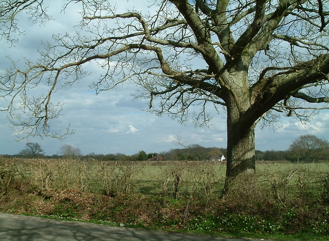
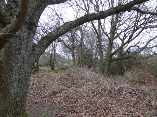
Birch Shaw is a picturesque woodland located in Sussex, England. Spread over a vast area, it is renowned for its abundance of birch trees, which lend the forest its name. The woodland is nestled amidst rolling hills and offers breathtaking views of the surrounding countryside.

Birch Shaw is home to a diverse range of flora and fauna, making it a popular destination for nature enthusiasts and wildlife photographers. The forest floor is carpeted with vibrant wildflowers during the spring and summer months, creating a stunning display of colors. The dense foliage of the birch trees provides ample shade and creates a tranquil atmosphere, perfect for those seeking a peaceful retreat from the hustle and bustle of daily life.

The forest boasts numerous walking trails, allowing visitors to explore its beauty at their own pace. These well-maintained paths wind through the woodland, offering glimpses of hidden clearings, babbling brooks, and ancient oak trees. The presence of a variety of bird species makes it an excellent spot for birdwatching, with sightings of woodpeckers, owls, and jays being common.

Birch Shaw is also steeped in history, with remnants of old settlements and stone structures scattered throughout the area. Archaeological excavations have unearthed artifacts dating back to ancient times, adding to the fascination and allure of the woodland.

Overall, Birch Shaw, Sussex (Wood, Forest) is a captivating destination for nature lovers, offering a serene and enchanting experience amidst its scenic beauty and rich history.

If you have any feedback on the listing, please let us know in the comments section below.

Birch Shaw Images

Images are sourced within 2km of 50.89615/0.19664875 or Grid Reference TQ5413. Thanks to Geograph Open Source API. All images are credited.

Chiddingly Church With a spire of 128'.
Chiddingly Church
With a spire of 128'.
Camberlot Farm Looking west from Camberlot Road.
Camberlot Farm
Looking west from Camberlot Road.
Old lane near Chalvington Many lanes and roads in this area of Sussex lead south to the pastures on the South Downs. With the arrival of the car many lanes were made up but some did not, lost their importance and now are bridleways or footpaths. This route begins deep in the Weald then heads south but stops at the A22, becoming a track until it reaches Chalvington Stud Farm before becoming a made up road again. What initially looks like a lane from the period of enclosures actually dates back to the Roman times. This view looks south and is taken the crossroads of tracks just south of the A22. See <a href="https://www.geograph.org.uk/gridref/TQ5311">TQ5311</a> for where the west track ends.
Old lane near Chalvington
Many lanes and roads in this area of Sussex lead south to the pastures on the South Downs. With the arrival of the car many lanes were made up but some did not, lost their importance and now are bridleways or footpaths. This route begins deep in the Weald then heads south but stops at the A22, becoming a track until it reaches Chalvington Stud Farm before becoming a made up road again. What initially looks like a lane from the period of enclosures actually dates back to the Roman times. This view looks south and is taken the crossroads of tracks just south of the A22. See TQ5311 for where the west track ends.
Crossroads near Golden Cross Looking north where the road from Chalvington turns left and heads for Golden Cross. Sheepcote Lane which turns right is a dead end but follows the route of the track from <a href="https://www.geograph.org.uk/gridref/TQ5411">TQ5411</a> before ending at Semeston Croft <a href="https://www.geograph.org.uk/gridref/TQ5309">TQ5309</a> and becoming a track again until reaching Chalvington. The northern route has not become a road and meets up with the track seen in TQ5411 a mile or so east.
Crossroads near Golden Cross
Looking north where the road from Chalvington turns left and heads for Golden Cross. Sheepcote Lane which turns right is a dead end but follows the route of the track from TQ5411 before ending at Semeston Croft TQ5309 and becoming a track again until reaching Chalvington. The northern route has not become a road and meets up with the track seen in TQ5411 a mile or so east.
Hedgerow Oak at Whitesmith Low Weald landscape looking towards Randall's Farm, with Chiddingly Church in the distance.
Hedgerow Oak at Whitesmith
Low Weald landscape looking towards Randall's Farm, with Chiddingly Church in the distance.
Golden Cross Inn, Golden Cross The road in front is the A22. The village itself has grown up around a crossroad junction of routes.
Golden Cross Inn, Golden Cross
The road in front is the A22. The village itself has grown up around a crossroad junction of routes.
The Old Mill, Golden Cross Built sometime in the early 19th century and known as either Wickens Mill or Dicker Mill. It remained operational until the eve of the First World War though only the roundhouse survives of the former post mill which has now been converted into a holiday home known as Jasmine Mill. See also <a href="https://www.geograph.org.uk/photo/2802150">TQ5312 : The Old Mill, Golden Cross</a> for a similar view.
The Old Mill, Golden Cross
Built sometime in the early 19th century and known as either Wickens Mill or Dicker Mill. It remained operational until the eve of the First World War though only the roundhouse survives of the former post mill which has now been converted into a holiday home known as Jasmine Mill. See also TQ5312 : The Old Mill, Golden Cross for a similar view.
Brickfields Farm Can you spot the cunningly disguised mobile phone mast?
Brickfields Farm
Can you spot the cunningly disguised mobile phone mast?
Scrappers Hill Farm Viewed from fields north of Hamly Bridge
Scrappers Hill Farm
Viewed from fields north of Hamly Bridge
Eight Acre Wood Taken from Nash Street.
Eight Acre Wood
Taken from Nash Street.
Nash Street Wood Following the footpath that leads to Thunder Hill
Nash Street Wood
Following the footpath that leads to Thunder Hill
Barn, Nash Street Farm Taken from Nash Street.
Barn, Nash Street Farm
Taken from Nash Street.
Peacocks, Nash Street Farm My first peacock point too.
Peacocks, Nash Street Farm
My first peacock point too.
The Old Toll House, Muddles Green The lane in muddles Green is not a major artery so I am assuming this was for tolls to use the turnpike that is now the A22 a little to the south of this hamlet. At one point this was also a shoe shop.
The Old Toll House, Muddles Green
The lane in muddles Green is not a major artery so I am assuming this was for tolls to use the turnpike that is now the A22 a little to the south of this hamlet. At one point this was also a shoe shop.
Chiddingly County Primary School Located in the hamlet of Muddles Green which is within the parish of Chiddingly.
Chiddingly County Primary School
Located in the hamlet of Muddles Green which is within the parish of Chiddingly.
Hale Farm House, Hale Green 14th century farm house converted into a bed and breakfast.
Hale Farm House, Hale Green
14th century farm house converted into a bed and breakfast.
Coneyburrow Wood The orchard to the left behind the hedge is called Carey Wood but unfortunately not accessible.
Coneyburrow Wood
The orchard to the left behind the hedge is called Carey Wood but unfortunately not accessible.
Hawthbush Farm The trees at the bottom of the field follow the course of a stream whilst Riverfield Shaw is to the right. The field is also suffering the after effects of the previous night's downpour.
Hawthbush Farm
The trees at the bottom of the field follow the course of a stream whilst Riverfield Shaw is to the right. The field is also suffering the after effects of the previous night's downpour.
Show me another place!

Birch Shaw is located at Grid Ref: TQ5413 (Lat: 50.89615, Lng: 0.19664875)

Administrative County: East Sussex

District: Wealden

Police Authority: Sussex

What 3 Words

///outnumber.mural.massaging. Near Horam, East Sussex

Related Wikis

Farleys House

Farleys House near Chiddingly, East Sussex, has been converted into a museum and archive featuring the lives and work of its former residents, the photographer...

Burgh Hill Farm Meadow

Burgh Hill Farm Meadow is a 0.9-hectare (2.2-acre) biological Site of Special Scientific Interest west of Hailsham in East Sussex.This meadow is managed...

Golden Cross, East Sussex

Golden Cross is a small village in the Wealden district of East Sussex, England. Its nearest town is Hailsham, which lies approximately 3+1⁄2 miles (6...

Chiddingly

Chiddingly ( CHID-ing-lye) is an English village and civil parish in the Wealden District of the administrative county of East Sussex, within historic...

Whitesmith maze

A plantation of willows near Whitesmith, East Sussex, in England forms a maze in the shape of a quotation from the Bible. The maze was planted by local...

Lower Dicker

Lower Dicker is a 0.1-hectare (0.25-acre) geological Site of Special Scientific Interest west of Hailsham in East Sussex. It is a Geological Conservation...

Gun Hill, East Sussex

Gun Hill is a hamlet in the civil parish of Chiddingly in the Wealden district of East Sussex, England. It is one of the seven hills of the parish in which...

Zoar Strict Baptist Chapel

Zoar Strict Baptist Chapel is a Strict Baptist place of worship in the hamlet of Lower Dicker in the English county of East Sussex. Founded in 1837 and...

Nearby Amenities

Located within 500m of 50.89615,0.19664875
Chiddingly Village Shop
Addr Housename: Farley's Farm Yard
Addr Postcode: BN8 6HW
Addr Street: Muddles Green
Alt Name: Chiddingly Community Village Shop
Designation: Community Shop
Fhrs Id: 444623
Shop: convenience
Source: http://www.chiddinglyshop.org
Website: http://www.chiddinglyshop.org
Lat/Long: 50.8991629/0.1971993
Farleys Barn Gallery
Addr City: Golden Cross
Addr Postcode: BN8 6HN
Addr Street: Muddles Green
Fhrs Id: 974206
Opening Hours: Su 10:00-15:30
Phone: +44 1825872856
Source: http://www.farleyfarmhouse.co.uk
Tourism: museum
Website: https://farleyshouseandgallery.co.uk/
Wheelchair: yes
Wikidata: Q5435428
Wikipedia: en:Farleys House
Lat/Long: 50.8990982/0.1978525
Defibrillator
Access: yes
Booth: K6
Covered: booth
Defibrillator Location: Inside old red phone box in Muddles Green, Chiddingly
Disused Amenity: telephone
Emergency: defibrillator
Man Made: telephone_box
Lat/Long: 50.8995192/0.1947447
Post Box
Collection Times: Mo-Fr 15:30; Sa 09:45
Operator: Royal Mail
Post Box Type: lamp
Ref: BN8 528
Royal Cypher: EIIR
Royal Cypher Wikidata: Q33102113
Website: https://www.royalmail.com/
Lat/Long: 50.8995068/0.1955742
Cafe
Chiddingly Village Shop & Café
Addr Street: Muddles Green
Cuisine: regional
Opening Hours: Mo-Fr 08:00-17:00; Sa 09:00-12:30
Lat/Long: 50.899706/0.1985042
Parking
Chidingly Car Parking
Access: yes
Capacity: 6
Park Ride: no
Parking: surface
Supervised: no
Wheelchair: yes
Lat/Long: 50.8995849/0.1987057
Farley Farm
Place: farm
Source Name: OS_OpenData_StreetView
Lat/Long: 50.8990204/0.1992559
Green Farm
Place: farm
Source Name: OS_OpenData_StreetView
Lat/Long: 50.8998866/0.1981294
Burgh Hill
Place: locality
Source: OS_OpenData_StreetView
Lat/Long: 50.8947573/0.190351
The data included in this document is from www.openstreetmap.org. The data is made available under ODbL.

Have you been to Birch Shaw?

Leave your review of Birch Shaw below (or comments, questions and feedback).