Burgh Hill

Hill, Mountain in Sussex Wealden

England

Burgh Hill

Chiddingly Church With a spire of 128'.
Chiddingly Church Credit: Pauline Kennard

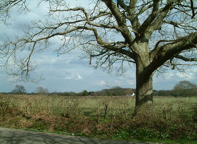
Burgh Hill is a prominent landmark located in Sussex, England. Situated in the South Downs, this hill is characterized by its gently sloping terrain and impressive elevation. Rising to a height of approximately 233 meters (764 feet), it offers breathtaking panoramic views of the surrounding countryside.

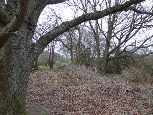
Covered in lush greenery and dotted with vibrant wildflowers during the warmer months, Burgh Hill is a haven for nature enthusiasts and hikers alike. The diverse flora and fauna found here make it an ideal spot for wildlife observation and photography.

The hill's geology is predominantly composed of chalk, which is common in the South Downs area. This chalky soil not only supports a wide variety of plant species but also contributes to the rich, fertile land surrounding the hill.

Burgh Hill is a popular destination for outdoor activities such as walking, hiking, and picnicking. Several well-marked trails crisscross the area, allowing visitors to explore its natural beauty at their own pace. Additionally, the hill is home to a number of historical landmarks, including ancient burial mounds and remnants of iron age settlements, providing a glimpse into the region's past.

Accessible by foot or car, Burgh Hill is a place of tranquility and natural beauty, offering visitors a chance to connect with nature and enjoy uninterrupted views of the Sussex landscape. Whether it's for a leisurely stroll, a challenging hike, or simply to admire the stunning scenery, Burgh Hill is a captivating destination for all.

If you have any feedback on the listing, please let us know in the comments section below.

Burgh Hill Images

Images are sourced within 2km of 50.895956/0.1902259 or Grid Reference TQ5413. Thanks to Geograph Open Source API. All images are credited.

Chiddingly Church With a spire of 128'.
Chiddingly Church
With a spire of 128'.
Old lane near Chalvington Many lanes and roads in this area of Sussex lead south to the pastures on the South Downs. With the arrival of the car many lanes were made up but some did not, lost their importance and now are bridleways or footpaths. This route begins deep in the Weald then heads south but stops at the A22, becoming a track until it reaches Chalvington Stud Farm before becoming a made up road again. What initially looks like a lane from the period of enclosures actually dates back to the Roman times. This view looks south and is taken the crossroads of tracks just south of the A22. See <a href="https://www.geograph.org.uk/gridref/TQ5311">TQ5311</a> for where the west track ends.
Old lane near Chalvington
Many lanes and roads in this area of Sussex lead south to the pastures on the South Downs. With the arrival of the car many lanes were made up but some did not, lost their importance and now are bridleways or footpaths. This route begins deep in the Weald then heads south but stops at the A22, becoming a track until it reaches Chalvington Stud Farm before becoming a made up road again. What initially looks like a lane from the period of enclosures actually dates back to the Roman times. This view looks south and is taken the crossroads of tracks just south of the A22. See TQ5311 for where the west track ends.
Crossroads near Golden Cross Looking north where the road from Chalvington turns left and heads for Golden Cross. Sheepcote Lane which turns right is a dead end but follows the route of the track from <a href="https://www.geograph.org.uk/gridref/TQ5411">TQ5411</a> before ending at Semeston Croft <a href="https://www.geograph.org.uk/gridref/TQ5309">TQ5309</a> and becoming a track again until reaching Chalvington. The northern route has not become a road and meets up with the track seen in TQ5411 a mile or so east.
Crossroads near Golden Cross
Looking north where the road from Chalvington turns left and heads for Golden Cross. Sheepcote Lane which turns right is a dead end but follows the route of the track from TQ5411 before ending at Semeston Croft TQ5309 and becoming a track again until reaching Chalvington. The northern route has not become a road and meets up with the track seen in TQ5411 a mile or so east.
Hedgerow Oak at Whitesmith Low Weald landscape looking towards Randall's Farm, with Chiddingly Church in the distance.
Hedgerow Oak at Whitesmith
Low Weald landscape looking towards Randall's Farm, with Chiddingly Church in the distance.
Golden Cross Inn, Golden Cross The road in front is the A22. The village itself has grown up around a crossroad junction of routes.
Golden Cross Inn, Golden Cross
The road in front is the A22. The village itself has grown up around a crossroad junction of routes.
The Old Mill, Golden Cross Built sometime in the early 19th century and known as either Wickens Mill or Dicker Mill. It remained operational until the eve of the First World War though only the roundhouse survives of the former post mill which has now been converted into a holiday home known as Jasmine Mill. See also <a href="https://www.geograph.org.uk/photo/2802150">TQ5312 : The Old Mill, Golden Cross</a> for a similar view.
The Old Mill, Golden Cross
Built sometime in the early 19th century and known as either Wickens Mill or Dicker Mill. It remained operational until the eve of the First World War though only the roundhouse survives of the former post mill which has now been converted into a holiday home known as Jasmine Mill. See also TQ5312 : The Old Mill, Golden Cross for a similar view.
Brickfields Farm Can you spot the cunningly disguised mobile phone mast?
Brickfields Farm
Can you spot the cunningly disguised mobile phone mast?
Bridleway, Eleven Acre Wood This narrow and muddy path links Ripe Lane with Broomham.
Bridleway, Eleven Acre Wood
This narrow and muddy path links Ripe Lane with Broomham.
Scrappers Hill Farm Viewed from fields north of Hamly Bridge
Scrappers Hill Farm
Viewed from fields north of Hamly Bridge
Eight Acre Wood Taken from Nash Street.
Eight Acre Wood
Taken from Nash Street.
Nash Street Wood Following the footpath that leads to Thunder Hill
Nash Street Wood
Following the footpath that leads to Thunder Hill
Barn, Nash Street Farm Taken from Nash Street.
Barn, Nash Street Farm
Taken from Nash Street.
Peacocks, Nash Street Farm My first peacock point too.
Peacocks, Nash Street Farm
My first peacock point too.
The Old Toll House, Muddles Green The lane in muddles Green is not a major artery so I am assuming this was for tolls to use the turnpike that is now the A22 a little to the south of this hamlet. At one point this was also a shoe shop.
The Old Toll House, Muddles Green
The lane in muddles Green is not a major artery so I am assuming this was for tolls to use the turnpike that is now the A22 a little to the south of this hamlet. At one point this was also a shoe shop.
Chiddingly County Primary School Located in the hamlet of Muddles Green which is within the parish of Chiddingly.
Chiddingly County Primary School
Located in the hamlet of Muddles Green which is within the parish of Chiddingly.
Hale Farm House, Hale Green 14th century farm house converted into a bed and breakfast.
Hale Farm House, Hale Green
14th century farm house converted into a bed and breakfast.
Coneyburrow Wood The orchard to the left behind the hedge is called Carey Wood but unfortunately not accessible.
Coneyburrow Wood
The orchard to the left behind the hedge is called Carey Wood but unfortunately not accessible.
Willow Cafe Part of the hamlet of Lower Dicker which grew up on the old common after enclosure. The cafe has seems to have been closed for some time.
Willow Cafe
Part of the hamlet of Lower Dicker which grew up on the old common after enclosure. The cafe has seems to have been closed for some time.
Show me another place!

Burgh Hill is located at Grid Ref: TQ5413 (Lat: 50.895956, Lng: 0.1902259)

Administrative County: East Sussex

District: Wealden

Police Authority: Sussex

What 3 Words

///tester.frown.fits. Near Horam, East Sussex

Related Wikis

Burgh Hill Farm Meadow

Burgh Hill Farm Meadow is a 0.9-hectare (2.2-acre) biological Site of Special Scientific Interest west of Hailsham in East Sussex.This meadow is managed...

Golden Cross, East Sussex

Golden Cross is a small village in the Wealden district of East Sussex, England. Its nearest town is Hailsham, which lies approximately 3+1⁄2 miles (6...

Farleys House

Farleys House near Chiddingly, East Sussex, has been converted into a museum and archive featuring the lives and work of its former residents, the photographer...

Whitesmith maze

A plantation of willows near Whitesmith, East Sussex, in England forms a maze in the shape of a quotation from the Bible. The maze was planted by local...

Chiddingly

Chiddingly ( CHID-ing-lye) is an English village and civil parish in the Wealden District of the administrative county of East Sussex, within historic...

Lower Dicker

Lower Dicker is a 0.1-hectare (0.25-acre) geological Site of Special Scientific Interest west of Hailsham in East Sussex. It is a Geological Conservation...

Gun Hill, East Sussex

Gun Hill is a hamlet in the civil parish of Chiddingly in the Wealden district of East Sussex, England. It is one of the seven hills of the parish in which...

RAF Deanland

RAF Deanland is a former Royal Air Force advanced landing ground located 4 miles (6.4 km) west of Hailsham, East Sussex and 13.4 miles (21.6 km) north...

Nearby Amenities

Located within 500m of 50.895956,0.1902259
Burgh Hill
Place: locality
Source: OS_OpenData_StreetView
Lat/Long: 50.8947573/0.190351
Burghill Farm
Place: farm
Source Name: OS_OpenData_StreetView
Lat/Long: 50.896378/0.1892835
Power: pole
Lat/Long: 50.8920588/0.1870143
The data included in this document is from www.openstreetmap.org. The data is made available under ODbL.

Have you been to Burgh Hill?

Leave your review of Burgh Hill below (or comments, questions and feedback).