Eleven Acre Wood

Wood, Forest in Sussex Wealden

England

Eleven Acre Wood

Crossroads near Golden Cross Looking north where the road from Chalvington turns left and heads for Golden Cross. Sheepcote Lane which turns right is a dead end but follows the route of the track from <a href="https://www.geograph.org.uk/gridref/TQ5411">TQ5411</a> before ending at Semeston Croft <a href="https://www.geograph.org.uk/gridref/TQ5309">TQ5309</a> and becoming a track again until reaching Chalvington. The northern route has not become a road and meets up with the track seen in TQ5411 a mile or so east.
Crossroads near Golden Cross Credit: Simon Carey

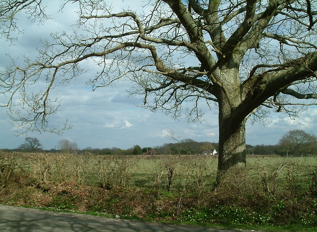
Eleven Acre Wood is a charming woodland located in Sussex, England. Spread across an area of approximately eleven acres, this forest is a haven of natural beauty and tranquility. The wood is characterized by its dense canopy of towering oak, beech, and chestnut trees, which provide ample shade and create a serene atmosphere.

The forest floor is blanketed with a lush carpet of ferns, moss, and wildflowers, adding to the enchanting ambiance of the wood. Walking through the woodland, visitors can enjoy the peaceful sound of birdsong and the occasional rustle of small animals scurrying about.

Eleven Acre Wood is home to a diverse range of wildlife, including deer, badgers, foxes, and a variety of bird species. Nature enthusiasts and birdwatchers flock to this woodland to catch a glimpse of these fascinating creatures in their natural habitat.

The wood is crisscrossed by a network of well-maintained walking trails, allowing visitors to explore the area at their own pace. These paths lead to hidden clearings and secluded spots, perfect for picnicking or simply enjoying the serenity of the surroundings.

Eleven Acre Wood is also a popular destination for nature photography, as its picturesque landscape offers ample opportunities to capture the beauty of the forest. Whether it is the vibrant colors of autumn or the delicate blooms of spring, the wood provides a stunning backdrop for capturing the changing seasons.

In conclusion, Eleven Acre Wood is a captivating woodland in Sussex that offers a peaceful retreat from the hustle and bustle of daily life. With its breathtaking scenery and abundant wildlife, it is a place where visitors can immerse themselves in the wonders of nature.

If you have any feedback on the listing, please let us know in the comments section below.

Eleven Acre Wood Images

Images are sourced within 2km of 50.890688/0.16306132 or Grid Reference TQ5212. Thanks to Geograph Open Source API. All images are credited.

Crossroads near Golden Cross Looking north where the road from Chalvington turns left and heads for Golden Cross. Sheepcote Lane which turns right is a dead end but follows the route of the track from <a href="https://www.geograph.org.uk/gridref/TQ5411">TQ5411</a> before ending at Semeston Croft <a href="https://www.geograph.org.uk/gridref/TQ5309">TQ5309</a> and becoming a track again until reaching Chalvington. The northern route has not become a road and meets up with the track seen in TQ5411 a mile or so east.
Crossroads near Golden Cross
Looking north where the road from Chalvington turns left and heads for Golden Cross. Sheepcote Lane which turns right is a dead end but follows the route of the track from TQ5411 before ending at Semeston Croft TQ5309 and becoming a track again until reaching Chalvington. The northern route has not become a road and meets up with the track seen in TQ5411 a mile or so east.
Stone Mason's Yard at Lower Vert Wood Site of the old sawmill for the Vert Wood complex, one of the largest ancient woodlands in the county, and an important site for butterflies and moths.
Stone Mason's Yard at Lower Vert Wood
Site of the old sawmill for the Vert Wood complex, one of the largest ancient woodlands in the county, and an important site for butterflies and moths.
Hedgerow Oak at Whitesmith Low Weald landscape looking towards Randall's Farm, with Chiddingly Church in the distance.
Hedgerow Oak at Whitesmith
Low Weald landscape looking towards Randall's Farm, with Chiddingly Church in the distance.
Stone Cross Farm Sussex Farmhouse at cross roads near Laughton.  Typical timber finger post marks the directions.
Stone Cross Farm
Sussex Farmhouse at cross roads near Laughton. Typical timber finger post marks the directions.
Golden Cross Inn, Golden Cross The road in front is the A22. The village itself has grown up around a crossroad junction of routes.
Golden Cross Inn, Golden Cross
The road in front is the A22. The village itself has grown up around a crossroad junction of routes.
The Old Mill, Golden Cross Built sometime in the early 19th century and known as either Wickens Mill or Dicker Mill. It remained operational until the eve of the First World War though only the roundhouse survives of the former post mill which has now been converted into a holiday home known as Jasmine Mill. See also <a href="https://www.geograph.org.uk/photo/2802150">TQ5312 : The Old Mill, Golden Cross</a> for a similar view.
The Old Mill, Golden Cross
Built sometime in the early 19th century and known as either Wickens Mill or Dicker Mill. It remained operational until the eve of the First World War though only the roundhouse survives of the former post mill which has now been converted into a holiday home known as Jasmine Mill. See also TQ5312 : The Old Mill, Golden Cross for a similar view.
Deanland Airfield Constructed in the spring of 1943 as an advanced airfield landing ground to help the D Day landings. It closed down after the war and was reactivated in 1963 by a local farmer as a landing strip for his own planes. From that point it grew as more people wished to have a base for their planes.
Deanland Airfield
Constructed in the spring of 1943 as an advanced airfield landing ground to help the D Day landings. It closed down after the war and was reactivated in 1963 by a local farmer as a landing strip for his own planes. From that point it grew as more people wished to have a base for their planes.
Pond, near Veals Farm A private angling pond next to the bridleway that links Ripe Lane with Broomhams. The building belongs to Deanland Airfield.
Pond, near Veals Farm
A private angling pond next to the bridleway that links Ripe Lane with Broomhams. The building belongs to Deanland Airfield.
Entrance to Green Lane Cottage The drive is in fact a bridleway that links Ripe with Deanland Road.
Entrance to Green Lane Cottage
The drive is in fact a bridleway that links Ripe with Deanland Road.
Brickfields Farm Can you spot the cunningly disguised mobile phone mast?
Brickfields Farm
Can you spot the cunningly disguised mobile phone mast?
Bridleway, Eleven Acre Wood This narrow and muddy path links Ripe Lane with Broomham.
Bridleway, Eleven Acre Wood
This narrow and muddy path links Ripe Lane with Broomham.
Chalvington Road Looking towards Golden Cross. The round building to the left is this, <a href="https://www.geograph.org.uk/photo/177461">TQ5312 : The Old Mill, Golden Cross</a> whilst the big white building to the right is a caravan showroom. The straightness of the road indicates that it was made after the enclosure of the former common.
Chalvington Road
Looking towards Golden Cross. The round building to the left is this, TQ5312 : The Old Mill, Golden Cross whilst the big white building to the right is a caravan showroom. The straightness of the road indicates that it was made after the enclosure of the former common.
Lone Oak Tree near Burgh Hill Taken from Vanguard Way looking towards Burghill Farm. Hoads Wood is to the left.
Lone Oak Tree near Burgh Hill
Taken from Vanguard Way looking towards Burghill Farm. Hoads Wood is to the left.
Hoads Wood With four Scots Pines in the foreground. Taken from the footpath that links Burgh Hill with Whitesmith.
Hoads Wood
With four Scots Pines in the foreground. Taken from the footpath that links Burgh Hill with Whitesmith.
Vanguard Way, Kiln Wood This part of the footpath begins at the A22 and heads towards Chiddingly.
Vanguard Way, Kiln Wood
This part of the footpath begins at the A22 and heads towards Chiddingly.
Whitesmith Lane The white building on the right is part of Whitesmith Farm which this small hamlet was originally built around. Interestingly a number of footpaths that should have run from the lane seem to not exist anymore.
Whitesmith Lane
The white building on the right is part of Whitesmith Farm which this small hamlet was originally built around. Interestingly a number of footpaths that should have run from the lane seem to not exist anymore.
Milepost, A22, Whitesmith 50 miles to the Bow Bells. See also <a href="https://www.geograph.org.uk/photo/263455">TQ5216 : Mile marker East Hoathly</a>
Milepost, A22, Whitesmith
50 miles to the Bow Bells. See also TQ5216 : Mile marker East Hoathly
Lilac Cottage, Whitesmith Small hamlet on the A22 which runs to the south out of the picture.
Lilac Cottage, Whitesmith
Small hamlet on the A22 which runs to the south out of the picture.
Show me another place!

Eleven Acre Wood is located at Grid Ref: TQ5212 (Lat: 50.890688, Lng: 0.16306132)

Administrative County: East Sussex

District: Wealden

Police Authority: Sussex

What 3 Words

///footballers.baffle.shunning. Near Hailsham, East Sussex

Related Wikis

RAF Deanland

RAF Deanland is a former Royal Air Force advanced landing ground located 4 miles (6.4 km) west of Hailsham, East Sussex and 13.4 miles (21.6 km) north...

Burgh Hill Farm Meadow

Burgh Hill Farm Meadow is a 0.9-hectare (2.2-acre) biological Site of Special Scientific Interest west of Hailsham in East Sussex.This meadow is managed...

Golden Cross, East Sussex

Golden Cross is a small village in the Wealden district of East Sussex, England. Its nearest town is Hailsham, which lies approximately 3+1⁄2 miles (6...

Whitesmith maze

A plantation of willows near Whitesmith, East Sussex, in England forms a maze in the shape of a quotation from the Bible. The maze was planted by local...

Laughton, East Sussex

Laughton is a village and civil parish in the Wealden district of East Sussex, England. The village is located five miles (8 km) east of Lewes, at a junction...

Farleys House

Farleys House near Chiddingly, East Sussex, has been converted into a museum and archive featuring the lives and work of its former residents, the photographer...

Park Corner Heath

Park Corner Heath is a 2.9-hectare (7.2-acre) biological Site of Special Scientific Interest about 1.2 miles (2 km) south of East Hoathly, adjacent to...

Chiddingly

Chiddingly ( CHID-ing-lye) is an English village and civil parish in the Wealden District of the administrative county of East Sussex, within historic...

Nearby Amenities

Located within 500m of 50.890688,0.16306132
Barrier: yes
Lat/Long: 50.8941123/0.1631544
The data included in this document is from www.openstreetmap.org. The data is made available under ODbL.

Have you been to Eleven Acre Wood?

Leave your review of Eleven Acre Wood below (or comments, questions and feedback).