Broadoak Wood

Wood, Forest in Sussex Wealden

England

Broadoak Wood

Old lane near Chalvington Many lanes and roads in this area of Sussex lead south to the pastures on the South Downs. With the arrival of the car many lanes were made up but some did not, lost their importance and now are bridleways or footpaths. This route begins deep in the Weald then heads south but stops at the A22, becoming a track until it reaches Chalvington Stud Farm before becoming a made up road again. What initially looks like a lane from the period of enclosures actually dates back to the Roman times. This view looks south and is taken the crossroads of tracks just south of the A22. See <a href="https://www.geograph.org.uk/gridref/TQ5311">TQ5311</a> for where the west track ends.
Old lane near Chalvington Credit: Simon Carey

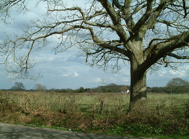
Broadoak Wood is a picturesque forest located in Sussex, England. Covering an area of approximately 100 acres, this wood is known for its rich biodiversity and stunning natural beauty. The forest is situated near the town of Broadoak, and its proximity to urban areas makes it easily accessible for visitors and nature enthusiasts.

The wood is primarily composed of broadleaf trees such as oak, beech, and birch, which give it its name. These majestic trees create a dense canopy, providing shade and shelter for a wide variety of flora and fauna. The forest floor is carpeted with a diverse array of wildflowers, ferns, and mosses, adding to its enchanting atmosphere.

Broadoak Wood is a haven for wildlife, with many species calling it home. Visitors may spot various bird species, including woodpeckers, owls, and thrushes, as well as small mammals like squirrels, hedgehogs, and foxes. The wood is also home to several species of butterflies and insects, making it a paradise for insect enthusiasts.

Walking trails wind through the forest, allowing visitors to explore its wonders at their own pace. These trails offer breathtaking views and opportunities to observe the woodland's inhabitants up close. Broadoak Wood provides a peaceful and serene environment, making it a popular destination for nature lovers, hikers, and photographers.

The forest is managed by local authorities, who strive to maintain its natural beauty and protect its diverse ecosystem. They promote responsible visitation, encouraging visitors to respect the wildlife and flora by staying on designated trails and disposing of litter properly.

In conclusion, Broadoak Wood is a captivating woodland in Sussex, England, boasting a diverse range of flora and fauna. Its tranquil ambiance and accessibility make it a perfect destination for those seeking a peaceful retreat in nature.

If you have any feedback on the listing, please let us know in the comments section below.

Broadoak Wood Images

Images are sourced within 2km of 50.894465/0.17135626 or Grid Reference TQ5212. Thanks to Geograph Open Source API. All images are credited.

Old lane near Chalvington Many lanes and roads in this area of Sussex lead south to the pastures on the South Downs. With the arrival of the car many lanes were made up but some did not, lost their importance and now are bridleways or footpaths. This route begins deep in the Weald then heads south but stops at the A22, becoming a track until it reaches Chalvington Stud Farm before becoming a made up road again. What initially looks like a lane from the period of enclosures actually dates back to the Roman times. This view looks south and is taken the crossroads of tracks just south of the A22. See <a href="https://www.geograph.org.uk/gridref/TQ5311">TQ5311</a> for where the west track ends.
Old lane near Chalvington
Many lanes and roads in this area of Sussex lead south to the pastures on the South Downs. With the arrival of the car many lanes were made up but some did not, lost their importance and now are bridleways or footpaths. This route begins deep in the Weald then heads south but stops at the A22, becoming a track until it reaches Chalvington Stud Farm before becoming a made up road again. What initially looks like a lane from the period of enclosures actually dates back to the Roman times. This view looks south and is taken the crossroads of tracks just south of the A22. See TQ5311 for where the west track ends.
Crossroads near Golden Cross Looking north where the road from Chalvington turns left and heads for Golden Cross. Sheepcote Lane which turns right is a dead end but follows the route of the track from <a href="https://www.geograph.org.uk/gridref/TQ5411">TQ5411</a> before ending at Semeston Croft <a href="https://www.geograph.org.uk/gridref/TQ5309">TQ5309</a> and becoming a track again until reaching Chalvington. The northern route has not become a road and meets up with the track seen in TQ5411 a mile or so east.
Crossroads near Golden Cross
Looking north where the road from Chalvington turns left and heads for Golden Cross. Sheepcote Lane which turns right is a dead end but follows the route of the track from TQ5411 before ending at Semeston Croft TQ5309 and becoming a track again until reaching Chalvington. The northern route has not become a road and meets up with the track seen in TQ5411 a mile or so east.
Stone Mason's Yard at Lower Vert Wood Site of the old sawmill for the Vert Wood complex, one of the largest ancient woodlands in the county, and an important site for butterflies and moths.
Stone Mason's Yard at Lower Vert Wood
Site of the old sawmill for the Vert Wood complex, one of the largest ancient woodlands in the county, and an important site for butterflies and moths.
Hedgerow Oak at Whitesmith Low Weald landscape looking towards Randall's Farm, with Chiddingly Church in the distance.
Hedgerow Oak at Whitesmith
Low Weald landscape looking towards Randall's Farm, with Chiddingly Church in the distance.
Stone Cross Farm Sussex Farmhouse at cross roads near Laughton.  Typical timber finger post marks the directions.
Stone Cross Farm
Sussex Farmhouse at cross roads near Laughton. Typical timber finger post marks the directions.
Golden Cross Inn, Golden Cross The road in front is the A22. The village itself has grown up around a crossroad junction of routes.
Golden Cross Inn, Golden Cross
The road in front is the A22. The village itself has grown up around a crossroad junction of routes.
The Old Mill, Golden Cross Built sometime in the early 19th century and known as either Wickens Mill or Dicker Mill. It remained operational until the eve of the First World War though only the roundhouse survives of the former post mill which has now been converted into a holiday home known as Jasmine Mill. See also <a href="https://www.geograph.org.uk/photo/2802150">TQ5312 : The Old Mill, Golden Cross</a> for a similar view.
The Old Mill, Golden Cross
Built sometime in the early 19th century and known as either Wickens Mill or Dicker Mill. It remained operational until the eve of the First World War though only the roundhouse survives of the former post mill which has now been converted into a holiday home known as Jasmine Mill. See also TQ5312 : The Old Mill, Golden Cross for a similar view.
Pond, near Veals Farm A private angling pond next to the bridleway that links Ripe Lane with Broomhams. The building belongs to Deanland Airfield.
Pond, near Veals Farm
A private angling pond next to the bridleway that links Ripe Lane with Broomhams. The building belongs to Deanland Airfield.
Entrance to Green Lane Cottage The drive is in fact a bridleway that links Ripe with Deanland Road.
Entrance to Green Lane Cottage
The drive is in fact a bridleway that links Ripe with Deanland Road.
Brickfields Farm Can you spot the cunningly disguised mobile phone mast?
Brickfields Farm
Can you spot the cunningly disguised mobile phone mast?
Bridleway, Eleven Acre Wood This narrow and muddy path links Ripe Lane with Broomham.
Bridleway, Eleven Acre Wood
This narrow and muddy path links Ripe Lane with Broomham.
Eight Acre Wood Taken from Nash Street.
Eight Acre Wood
Taken from Nash Street.
The Old Toll House, Muddles Green The lane in muddles Green is not a major artery so I am assuming this was for tolls to use the turnpike that is now the A22 a little to the south of this hamlet. At one point this was also a shoe shop.
The Old Toll House, Muddles Green
The lane in muddles Green is not a major artery so I am assuming this was for tolls to use the turnpike that is now the A22 a little to the south of this hamlet. At one point this was also a shoe shop.
Chiddingly County Primary School Located in the hamlet of Muddles Green which is within the parish of Chiddingly.
Chiddingly County Primary School
Located in the hamlet of Muddles Green which is within the parish of Chiddingly.
Chalvington Road Looking towards Golden Cross. The round building to the left is this, <a href="https://www.geograph.org.uk/photo/177461">TQ5312 : The Old Mill, Golden Cross</a> whilst the big white building to the right is a caravan showroom. The straightness of the road indicates that it was made after the enclosure of the former common.
Chalvington Road
Looking towards Golden Cross. The round building to the left is this, TQ5312 : The Old Mill, Golden Cross whilst the big white building to the right is a caravan showroom. The straightness of the road indicates that it was made after the enclosure of the former common.
Threatening Skies over Muddles Green Sunshine in this grid square but heavy showers a few grid squares to the north. The buildings in the foreground are in Muddles Green, that with the scaffolding is this, <a href="https://www.geograph.org.uk/photo/267457">TQ5413 : Chiddingly County Primary School</a>. The spire of Chiddingly church stands out amongst the grey clouds.
Threatening Skies over Muddles Green
Sunshine in this grid square but heavy showers a few grid squares to the north. The buildings in the foreground are in Muddles Green, that with the scaffolding is this, TQ5413 : Chiddingly County Primary School. The spire of Chiddingly church stands out amongst the grey clouds.
Lone Oak Tree near Burgh Hill Taken from Vanguard Way looking towards Burghill Farm. Hoads Wood is to the left.
Lone Oak Tree near Burgh Hill
Taken from Vanguard Way looking towards Burghill Farm. Hoads Wood is to the left.
Hoads Wood With four Scots Pines in the foreground. Taken from the footpath that links Burgh Hill with Whitesmith.
Hoads Wood
With four Scots Pines in the foreground. Taken from the footpath that links Burgh Hill with Whitesmith.
Show me another place!

Broadoak Wood is located at Grid Ref: TQ5212 (Lat: 50.894465, Lng: 0.17135626)

Administrative County: East Sussex

District: Wealden

Police Authority: Sussex

What 3 Words

///thing.flanks.bookmark. Near Horam, East Sussex

Related Wikis

Burgh Hill Farm Meadow

Burgh Hill Farm Meadow is a 0.9-hectare (2.2-acre) biological Site of Special Scientific Interest west of Hailsham in East Sussex.This meadow is managed...

Golden Cross, East Sussex

Golden Cross is a small village in the Wealden district of East Sussex, England. Its nearest town is Hailsham, which lies approximately 3+1⁄2 miles (6...

Whitesmith maze

A plantation of willows near Whitesmith, East Sussex, in England forms a maze in the shape of a quotation from the Bible. The maze was planted by local...

Farleys House

Farleys House near Chiddingly, East Sussex, has been converted into a museum and archive featuring the lives and work of its former residents, the photographer...

RAF Deanland

RAF Deanland is a former Royal Air Force advanced landing ground located 4 miles (6.4 km) west of Hailsham, East Sussex and 13.4 miles (21.6 km) north...

Chiddingly

Chiddingly ( CHID-ing-lye) is an English village and civil parish in the Wealden District of the administrative county of East Sussex, within historic...

Park Corner Heath

Park Corner Heath is a 2.9-hectare (7.2-acre) biological Site of Special Scientific Interest about 1.2 miles (2 km) south of East Hoathly, adjacent to...

East Hoathly with Halland

East Hoathly with Halland is a civil parish in the Wealden District of East Sussex, England. The parish contains the two villages of East Hoathly and...

Nearby Amenities

Located within 500m of 50.894465,0.17135626
Bench
Lat/Long: 50.8955939/0.1754151
Bench
Lat/Long: 50.8955727/0.175336
Holmes's Hill
Place: hamlet
Source: OS_OpenData_Streetview
Lat/Long: 50.8943682/0.1776937
Parking
Capacity: 3
Parking: lane
Lat/Long: 50.897945/0.1755418
The data included in this document is from www.openstreetmap.org. The data is made available under ODbL.

Have you been to Broadoak Wood?

Leave your review of Broadoak Wood below (or comments, questions and feedback).